Please wait a minute...
 
自然资源遥感  2021, Vol. 33 Issue (4): 173-180    DOI: 10.6046/zrzyyg.2021007
  技术应用 本期目录 | 过刊浏览 | 高级检索 |
基于CZMIL测深技术的海陆一体地形测量初探
吴芳1(), 金鼎坚1, 张宗贵1, 冀欣阳1, 李天祺1, 高宇2
1.中国自然资源航空物探遥感中心,北京 100083
2.Teledyne Optech, Inc., Ontario L4K5Z8, Canada
A preliminary study on land-sea integrated topographic surveying based on CZMIL bathymetric technique
WU Fang1(), JIN Dingjian1, ZHANG Zonggui1, JI Xinyang1, LI Tianqi1, GAO Yu2
1. China Aero Geophysical Survey and Remote Sensing Center for Natural and Resources, Beijing 100083, China
2. Teledyne Optech, Inc., Ontario L4K5Z8, Canada
全文: PDF(3992 KB)   HTML  
输出: BibTeX | EndNote (RIS)      
摘要 

常规区域性水深测量方法主要是利用船载的声学探测技术,但是由于船体无法进入沿岸浅水区域和岛礁密集区域,故近海岸区域常存在数据空白。机载激光雷达测深技术的出现和发展能有效解决这一问题,成为一种快速高效的水深及海底地形测探方法。以机载激光雷达测深仪CZMIL Nova系统为例,介绍其海陆地形一体化的测量技术特点和影响因素,及其在岛屿海陆一体地形测量的初步应用情况。

服务
把本文推荐给朋友
加入引用管理器
E-mail Alert
RSS
作者相关文章
吴芳
金鼎坚
张宗贵
冀欣阳
李天祺
高宇
关键词 机载激光雷达测深CZMIL遥感海岸带地形    
Abstract

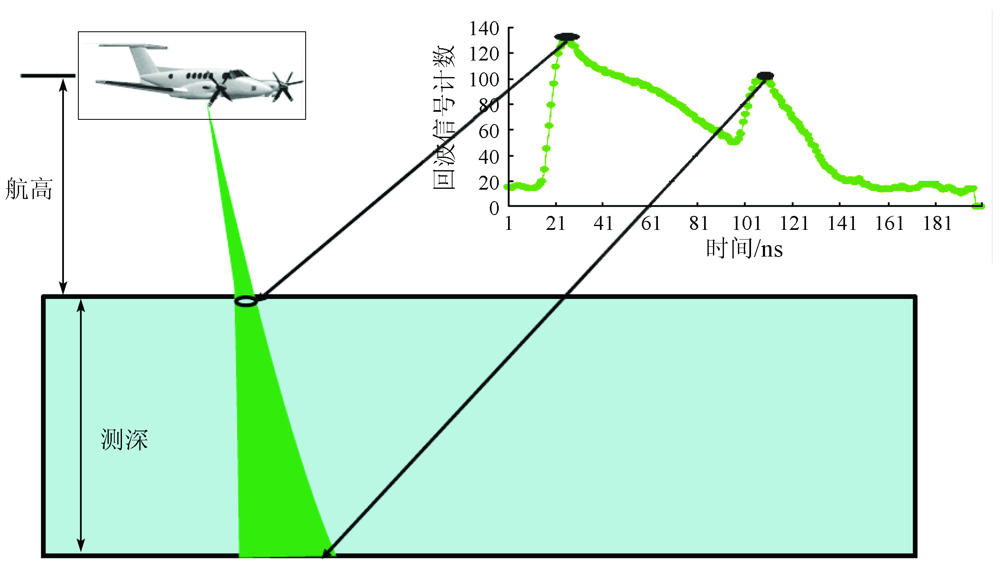
Conventional methods for regional bathymetry mainly use shipborne acoustic detection technologies. However, since the hull cannot access the coastal shallow waters and the areas with dense islands and coral reefs, there is no available data of near-coastal areas. These problems can be effectively solved with the emergence and development of airborne lidar bathymetric technology, which has become a fast and efficient method for water-depth and submarine topographic exploration. Based on the airborne laser sounder CZMIL Nova, this paper introduces the characteristics and influencing factors of the land-sea integrated technologic surveying and its preliminary application in the land-sea integrated topographic surveying of islands.

Key wordsairborne laser bathymetry    CZMIL    remote sensing    coastal zone    topography
收稿日期: 2021-01-08      出版日期: 2021-12-23
ZTFLH:  TP79  
基金资助:高分专项(民用)项目“高分航空载荷自然资源调查应用示范”(04-H30G01-9001-20122);中国地质调查局项目“渤海海岸带航空物探遥感调查及应用”(DD20160150)
作者简介: 吴 芳(1980-),女,硕士,高级工程师,主要研究方向为航空遥感技术在地质调查中的应用。Email: 4402744@qq.com
引用本文:   
吴芳, 金鼎坚, 张宗贵, 冀欣阳, 李天祺, 高宇. 基于CZMIL测深技术的海陆一体地形测量初探[J]. 自然资源遥感, 2021, 33(4): 173-180.
WU Fang, JIN Dingjian, ZHANG Zonggui, JI Xinyang, LI Tianqi, GAO Yu. A preliminary study on land-sea integrated topographic surveying based on CZMIL bathymetric technique. Remote Sensing for Natural Resources, 2021, 33(4): 173-180.
链接本文:  
https://www.gtzyyg.com/CN/10.6046/zrzyyg.2021007      或      https://www.gtzyyg.com/CN/Y2021/V33/I4/173
类别 技术指标 CZMIL Nova Hawk Eye III VQ-880G LADS MK III
一般指标 工作航高/m 400 ~1 000 400 ~600 600 ~1 600 400 ~1 000
飞行速度/kts 140 ~175 140 ~175 140 ~175 125 ~175
测量指标 激光扫描频率/kHz 水深70/10地形 80 水深35/10地形 500 550 512/1.5
最大测深 1.5 secchi 标称3.0 secchi
最深可达80 m
浅水2.0/ K d 浅水2.2/ K d
深水4.2/ K d 深水4.0/ K d
0 . 3 2 + 0.013 d 2  m, 2σ 0 . 3 2 + 0.013 d 2   m, 2σ
测深精度 0.025 m 0.5 m
水深 0.8 m×0.8 m
陆地 0.3 m×0.3 m
水深 0.8 m×0.8 m
陆地 0.1 m×0.1 m
测点密度 标称69 pts/m2 2 m×2 m
Tab.1  典型机载激光测深雷达系统主要技术指标
Fig.1  机载激光测深原理图[10]
Fig.2-1  机载水深测量系统激光地形测量剖面分析
Fig.2-2  机载水深测量系统激光地形测量剖面分析
Fig.3  CZMIL Nova 海陆一体地形测量
Fig.4  底质反射率曲线(摘自中心仪器测试报告)
水质情况 Kd Dmax(白天)/m Dmax(夜间)/m
非常洁净 0.07 50 71
洁净 0.10 35 50
水质情况 Kd Dmax(白天)/m Dmax(夜间)/m
一般洁净1 0.15 23 33
一般洁净2 0.20 18 25
浑浊 0.30 12 17
非常浑浊 0.50 7 10
Tab.2  CZMIL系统最大探测深度(Optech,2013)
Fig.5  机载激光雷达测深技术流程
Fig.6  激光经检校后效果
统计参数 深度 平均误差 标准差 RMSE 系统标
称精度
数值 30 -0.304 0.211 0.369 0.492
Tab.3  测试区激光测量精度统计
Fig.7  海陆一体地形产品应用
[1] 徐广袖, 翟国君, 吴太旗, 等. 机载激光测深作业的关键技术问题[J]. 海洋测绘, 2019,39(2):45-49.
Xu G X, Zhai G J, Wu T Q, et al. The key technical issues on airborne LiDAR bathymetry operation[J]. Hydrographic Surveying and Charting, 2019,39(2):45-49.
[2] 刘焱雄, 郭锴, 何秀风, 等. 机载激光测深技术及其研究进展[J]. 武汉大学学报(信息科学版), 2017,42(9):1185-1194.
Liu Y X, Guo K, He X F, et al. Research progress of airborne laser bathymetry technology[J]. Geomatics and Information Science of Wuhan University, 2017,42(9):1185-1194.
[3] 翟国君, 王克平, 刘玉红. 机载激光测深技术[J]. 海洋测绘, 2014,34(2):72-75.
Zhai G J, Wang K P, Liu Y H. Technology of airborne laser bathymetry[J]. Hydrographic Surveying and Charting, 2014,34(2):72-75.
[4] 翟国君, 吴太旗, 欧阳永忠, 等. 机载激光测深技术研究进展[J]. 海洋测绘, 2012,32(2):67-71.
Zhai G J, Wu T Q, Ouyang Y Z, et al. The development of airborne laser bathymetry[J]. Hydrographic Surveying and Charting, 2012,32(2):67-71.
[5] 刘智敏, 杨安秀, 阳凡林, 等. 机载LiDAR测深在海洋测绘中应用的可行性分析[J]. 海洋测绘, 2018,38(4):43-47.
Liu Z M, Yang A X, Yang F L, et al. The feasibility analysis for the airborne LiDAR bathymetry application in marine surveying and charting[J]. Hydrographic Surveying and Charting, 2018,38(4):43-47.
[6] CZMIL HydroFusion Manual & CZMIL Operation Manual[Z]. Canada:Teledyne Optech Inc. 2017.
[7] 贺岩, 胡善江, 陈卫标, 等. 国产机载双频激光雷达探测技术研究进展[J]. 激光与光电子学进展, 2018,55(8):082801.
He Y, Hu S J, Chen W B, et al. Research progress of domestic airborne dual-frequency LiDAR detection technology[J]. Laser & Optoelectronics Progress, 2018,55(8):082801.
[8] Tuell G, Barbor K, Wozencraft J. Overview of the coastal zone mapping and imaging LiDAR(CZMIL):A new multi-sensor airborne mapping system for the U.S. army corps of engineers[C]//Proceedings of SPIE-The International Society for Optical Engineering, 2010.
[9] 毕世普, 别君, 张勇. 机载LiDAR在海岸带地形测量中的应用[J]. 海洋地质前沿, 2012,28(11):59-63.
Bi S P, Bie J, Zhang Y. Application of airborne LiDAR to coastial topographic survey[J]. Marine Geology Letters, 2012,28(11):59-63.
[10] 叶修松. 机载激光水深探测技术基础及数据处理方法研究[D]. 郑州:解放军信息工程大学, 2010.
Ye X S. Research on principle and data processing methods of airborne laser bathymetric technique[D]. Zhengzhou:Information Engineering University, 2010.
[11] Fuchs E, Tuell G. Conceptual design of the CZMIL data acquisition system (DAS):Integrating a new bathymetric lidar with a commercial spectrometer and metric camera for coastal mapping applications[C]//Proceedings of SPIE-The International Society for Optical Engineering, 2010.
[12] 金鼎坚, 吴芳, 于坤, 等. 机载激光雷达测深系统大规模应用测试与评估——以中国海岸带为例[J]. 红外与激光工程, 2020,49(s2):9-23.
Jin D J, Wu F, Yu K, et al. Large-scale application test and evaluation of an airborne lidar bathymetry system——A case study in China’s coastal zone[J]. Infrared and Laser Engineering, 2020,49(s2):9-23.
[13] Tuell G, Barbor K, Wozencraft J. Overview of the coastal zone mapping and imaging LiDAR (CZMIL):A new multi-sensor airborne mapping system for the U.S. Army Corps of Engineers[C]//SPIE, 2010,7695:76950R.
[14] 王宗伟, 朱士才, 卢刚, 等. CZMIL机载激光测深系统及其在骆马湖测深试验评估[J]. 海洋学研究, 2017,35(3):20-26.
Wang Z W, Zhu S C, Lu G, et al. CZMIL airborne laser sounding system and its testing evaluation in Luoma Lake[J]. Journal of Marine Sciences, 2017,35(3):20-26.
[15] CZMIL Calibration Survey Requirements[Z]. Canada:Teledyne Optech Inc. 2017.
[16] 亓发庆, 黎广钊, 孙永福, 等. 北部湾涠洲岛地貌的基本特征[J]. 海洋科学进展, 2003,21(1):41-50.
Qi F Q, Ni G Z, Sun Y F, et al. Basic geomorphologic features of the Weizhou Island of the Beibu Bay[J]. Advances in Marine Science, 2003,21(1):41-50.
[1] 王建强, 邹朝晖, 刘荣波, 刘志松. 基于U2-Net深度学习模型的沿海水产养殖塘遥感信息提取[J]. 自然资源遥感, 2023, 35(3): 17-24.
[2] 唐晖, 邹娟, 尹向红, 余姝辰, 贺秋华, 赵动, 邹聪, 罗建强. 基于高分遥感的洞庭湖区河湖采砂监管及典型案例分析[J]. 自然资源遥感, 2023, 35(3): 302-309.
[3] 于航, 安娜, 汪洁, 邢宇, 许文佳, 步凡, 王晓红, 杨金中. 黔西南采煤塌陷区高分遥感动态监测——以六盘水市煤矿采空塌陷区为例[J]. 自然资源遥感, 2023, 35(3): 310-318.
[4] 王静, 王佳, 徐江琪, 黄邵东, 刘东云. 改进遥感生态指数的典型海岸带城市生态环境质量评价——以湛江市为例[J]. 自然资源遥感, 2023, 35(3): 43-52.
[5] 闫柏琨, 甘甫平, 印萍, 葛晓立, 郭艺, 白娟. 1989—2021年中国大陆海岸带潮滩、海岸线、养殖水体遥感观测[J]. 自然资源遥感, 2023, 35(3): 53-63.
[6] 徐欣钰, 李小军, 赵鹤婷, 盖钧飞. NSCT和PCNN相结合的遥感图像全色锐化算法[J]. 自然资源遥感, 2023, 35(3): 64-70.
[7] 刘立, 董先敏, 刘娟. 顾及地学特征的遥感影像语义分割模型性能评价方法[J]. 自然资源遥感, 2023, 35(3): 80-87.
[8] 陈凯, 王春, 代文, 盛业华, 刘爱利, 汤国安. 基于控制点蒙特卡罗检验的无人机地形建模精度影响因素研究[J]. 自然资源遥感, 2023, 35(3): 107-115.
[9] 牛祥华, 黄微, 黄睿, 蒋斯立. 基于注意力特征融合的高保真遥感图像薄云去除[J]. 自然资源遥感, 2023, 35(3): 116-123.
[10] 董婷, 符潍奇, 邵攀, 高利鹏, 武昌东. 基于改进全连接条件随机场的SAR影像变化检测[J]. 自然资源遥感, 2023, 35(3): 134-144.
[11] 郭晓萌, 方秀琴, 杨露露, 曹煜. 基于人工神经网络的西辽河流域根区土壤湿度估算[J]. 自然资源遥感, 2023, 35(2): 193-201.
[12] 方贺, 张育慧, 何月, 李正泉, 樊高峰, 徐栋, 张春阳, 贺忠华. 浙江省植被生态质量时空变化及其驱动因素分析[J]. 自然资源遥感, 2023, 35(2): 245-254.
[13] 张仙, 李伟, 陈理, 杨昭颖, 窦宝成, 李瑜, 陈昊旻. 露天开采矿区要素遥感提取研究进展及展望[J]. 自然资源遥感, 2023, 35(2): 25-33.
[14] 马世斌, 皮英楠, 王佳, 张焜, 李生辉, 彭玺. 基于遥感的绿色勘查高效监管方法体系研究[J]. 自然资源遥感, 2023, 35(2): 255-263.
[15] 王平. 热红外遥感技术在钢铁去产能监测中的应用[J]. 自然资源遥感, 2023, 35(2): 271-276.
Viewed
Full text


Abstract

Cited

  Shared   
  Discussed   
京ICP备05055290号-2
版权所有 © 2015 《自然资源遥感》编辑部
地址:北京学院路31号中国国土资源航空物探遥感中心 邮编:100083
电话:010-62060291/62060292 E-mail:zrzyyg@163.com
本系统由北京玛格泰克科技发展有限公司设计开发