The remote sensing-based estimation and spatial-temporal dynamic analysis of SOM in coal mining
GAO Wenlong1(), ZHANG Shengwei1,2,3(), LIN Xi1, LUO Meng1, REN Zhaoyi1
1. College of Water Conservancy and Civil Engineering, Inner Mongolia Agricultural University, Hohhot 010018, China 2. Key Laboratory of Protection and Utilization of Water Resources of Inner Mongolia Atuonomous Region, Hohhot 010018, China 3. Inner Mongolia Autonomous Region Key Laboratory of Big Data Research and Application of Agriculture and Animal Husbandry, Hohhot 010018, China
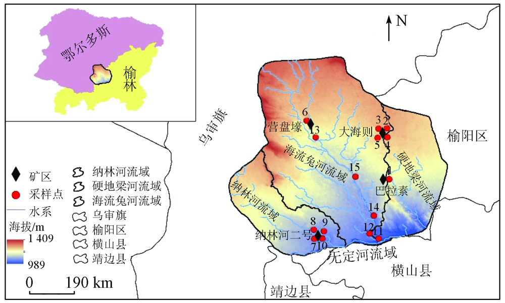
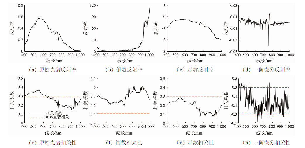
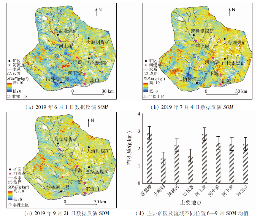
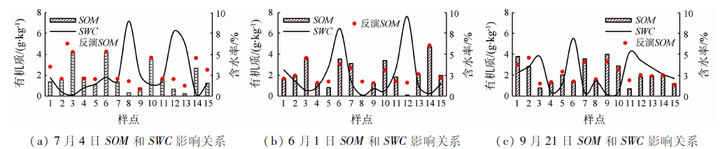
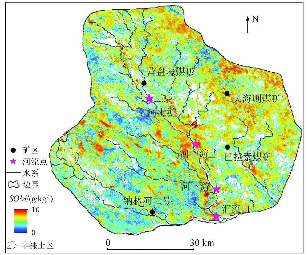
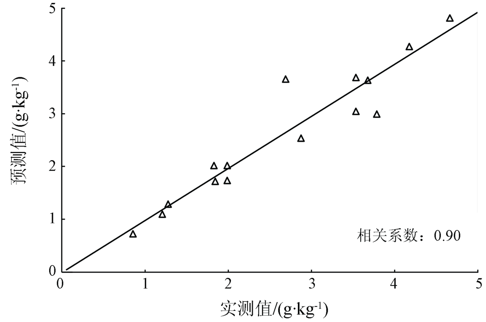
Soil is the largest potential reservoir of carbon, and the content of soil organic matter (SOM) is the key influencing factor of soil carbon storage. Therefore, SOM is an important index in the analysis of the changes in soil carbon storage. This paper aims to understand the optimal response bands in spectra to the SOM content in the process of coal mining and the changes in the temporal-spatial dynamic patterns of the SOM in a whole coal mining area. Based on the linear regression analysis of measured SOM, near-earth hyperspectral reflectance, and satellite multispectral reflectance, the SOM changes in the study area on June 1, July 4, and September 21, 2019 were quantitatively analyzed, and the SOM changes in underground coal mines (named Dahaize, Balasu, Nalinhe 2, and Yingpanhao) and their surrounding river basins were monitored. The SOM inversion results obtained using the first-order differential transformation of the near-earth hyperspectral reflectance were the closest to the measured SOM. A regression inversion model was established based on the extracted hyperspectral and multispectral characteristic bands and their correlation with the SOM. As indicated by the precision verification results, the correlation between the values predicted through SOM reversion and measured SOM values reached 0.90. Meanwhile, the SOM content in the study area was high in the east and low in the west and it gradually decreased along the upper, middle, and lower reaches of rivers and estuaries. The SOM content obtained through pre-mining simulation was 5% higher than that acquired via remote sensing-based estimation, indicating that coal mining affects the SOM content to a certain extent. It is also proven that the linear regression model of SOM inversion has the prospect of wide application. The above results will provide bases for quantitative research, management, and sustainable development of soil resources and ecological environment in the study area.
Tian S Q, Wang L, Liu Y L, et al. Degradation of organic pollutants by ferrate/biochar:Enhanced formation of strong intermediate oxidative iron species[J]. Water Research, 2020,183,116054.
doi: 10.1016/j.watres.2020.116054
[2]
Thomas G, Léa C, Yann Q, et al. Historical CO2 emissions from land use and land cover change and their uncertainty[J]. Biogeoscuences, 2020,17(15):4075-4101.
[3]
Emily E, Oldfield S, et al. Direct evidence using a controlled greenhouse study for threshold effects of soil organic matter on crop growth[J]. Ecological Applications, 2020,30(4):1-12.
[4]
Cheng Q, Jia W, Hu G X, et al. Enhancement and improvement of selenium in soil to the resistance of rape stem against Sclerotinia sclerotiorum and the inhibition of dissolved organic matter derived from rape straw on mycelium[J]. Environmental Pollution, 2020,265,114827.
doi: S0269-7491(20)30775-2
pmid: 32454382
Cheng P G, Wu J, Li D J, et al. Quantitative prediction of soil organic matter content using hyper spectral remote senging and geo-statistics[J]. Transactions of the Chinese Society of Agricultural Engineering, 2009,25(3):142-147.
[6]
Sparling G P, Wheeler D, Vesely E T, et al. What is soil organic matter worth?[J]. Journal of Environmental Quality, 2006,35(2):548-557.
pmid: 16510699
Xia N, Ding J L, et al. Estimation model of soil organic matter in desert mining area based on multispectral image data[J]. Transactions of the Chinese Society of Agricultural Engineering, 2016,32(6):263-267.
[8]
Qiao X X, Wang C, Feng M C, et al. Hyperspectral estimation of soil organic matter based on different spectral preprocessing techniques[J]. Spectroscopy Letters, 2017,50(3):156-163.
doi: 10.1080/00387010.2017.1297958
Liu M J, Xu Z K, Gao Y B, et al. Estimating soil organic matter based on machine learning under sparse sample[J]. Journal of Geo-information Science, 2020,22(9):1799-1813.
[10]
Paula A, Luis E, Sáenz de M, et al. Influence of environmental variables on the structure and composition of soil bacterial communities in natural and constructed wetlands[J]. Science of the Total Environment, 2015, 506-507:380-390.
doi: 10.1016/j.scitotenv.2014.11.039
[11]
Ana M G, Leopoldo G. Land-use/cover change effects and carbon controls on volcanic soil profiles in highland temperate forests[J]. Geoderma, 2012(170):390-402.
He J L, Han C S, Wei R, et al. Research on indirect hyperspectral estimating model of heavy metal Cd based on partial least squares regression[J]. Remote Sensing for Land and Resources, 2019,31(4):96-103.doi: 10.6046/gtzyyg.2019.04.13.
doi: 10.6046/gtzyyg.2019.04.13
Nie Z, Li X F, Lyu J X, et al. Hyperspectral retrieval of surface soil organic matter content in a typical black soil region of northeast china[J]. Chinese Jourmal of Soil Science, 2019,50(6):1285-1293.
[14]
Lin C, Zhu A X, Wang Z F, et al. The refined spatiotemporal representation of soil organic matter based on remote images fusion of Sentinel-2 and Sentinel-3[J]. International Journal of Applied Earth Observations and Geoinformation, 2020,89, 1102094.
[15]
Galvao L S, Vitorello I. Variability of laboratory measured soil lines of soils from southheastern Brazil[J]. Remote Sensing of Environment, 1998(63):166-181.
Yasenjiang K, Yang S T, Nigara T, et al. Hyperspectral estimation of soil electrical conductivity based on fractional order differentially optimised spectral indices[J]. Acta Ecologica Sinica, 2019,39(19):7237-7248.
Ye Q, Jiang X Q, Li X C, et al. Comparison on inversion model of soil organic matter content based on hyperspectral data[J]. Transactions of the Chinese Society for Agricultural Machinery, 2017,48(3):164-172.
[19]
Zhu M K, Kong F L, Li Y, et al. Effects of moisture and salinity on soil dissolved organic matter and ecological risk of coastal wetland[J]. Environmental Research, 2020,187,109659.
doi: 10.1016/j.envres.2020.109659
[20]
Hong Y S, Chen S C, Zhang Y, et al. Rapid identification of soil organic matter level via visible and near-infrared spectroscopy:Effects of two-dimensional correlation coefficient and extreme learning machine[J]. Science of the Total Environment, 2018,644:1232-1243.
doi: 10.1016/j.scitotenv.2018.06.319
[21]
Al-Abbas A H, Swain P H, Baumgarder M F, et al. Relating organic matter and clay content to the multi-spectral radiance of soils[J]. Soil Science, 1972,114(6):477-485.
doi: 10.1097/00010694-197212000-00011
Guo J X, Zhu Q, Zhao X M, et al. Hyper-spectral inversion of soil organic carbon content under different land use typrs[J]. Chinese Journal of Applied Ecology, 2020,31(3):863-871.
Mao L, Su Z Z, Wang G L, et al. Soil particle size and organic matter content of different land use types in the Mu Us sandland[J]. Arid Zone Research, 2019,36(3):589-598.
[24]
Lin L X, Gao L P, Xue F C, et al. Hyperspectral analysis of total nitrogen in soil using a synchronized decoloring fuzzy measured value method[J]. Soil & Tillage Research, 2020,202:104658.
Yasenjiang K, Rukeya S, Nijat K, et al. Estimation of heavy metal contents in soil around open pit coal mine area based on optimized spectral index[J]. Spectroscopy and Spectral Analysis, 2019,39(8):2486-2494.
doi: 10.3964/j.issn.1000-0593(2019)08-2486-09
[26]
Tatiana F R, Luiza C, et al. Temperature sensitivity of soil organic matter decomposition varies with biochar application and soil type[J]. Pedosphere, 2020,30(3):336-345.
doi: 10.1016/S1002-0160(20)60013-3
Hou Z F, Liu R Y, Yan B K, et al. Hyperspectral imagery anomaly detection based on band selection and learning dictionary[J]. Remote Sensing for Land and Resources, 2019,31(1):33-41.doi: 10.6046/gtzyyg.2019.01.05.
doi: 10.6046/gtzyyg.2019.01.05
[28]
Patel S S, Ramachandran P. A comparison of machine learning techniques for modeling river flow time series:The case of upper Cauvery River Basin[J]. Water Resources Management, 2015,29(2):589-602.
doi: 10.1007/s11269-014-0705-0
Zheng Z P, Liu X Z, et al. Soil quality and its evaluation[J]. Chinese Journal of Applied Ecology, 2003,14(1):131-134.
[30]
Moura-Bueno J M, Dalmolin R S D, Caten A T, et al. Stratification of a local VIS-NIR-SWIR spectral library by homogeneity criteria yields more accurate soil organic carbon predictions[J]. Geoderma, 2019,337:565-581.
doi: 10.1016/j.geoderma.2018.10.015
[31]
Gomez C, Adeline K, Bacha S, et al. Sensitivity of clay content prediction to spectral configuration of VNIR/SWIR imaging data,from multispectral to hyperspectral scenarios[J]. Remote Sensing of Environment, 2018,204:18-30.
doi: 10.1016/j.rse.2017.10.047
Zhang M, Liu S, Liu Y, et al. Soil moisture variation characteristics of different land use types in the moderate slope sandy area of loess hilly region[J]. Journal of Soil and Water Conservation, 2019,33(3):115-120,128.
[33]
Wang D, He N P, Wang Q, et al. Effects of temperature and moisture on soil organic matter decomposition along elevation gradients on the Changbai Mountains,Northeast China[J]. Pedosphere, 2016,26(3):399-407.
doi: 10.1016/S1002-0160(15)60052-2
[34]
Peng F, Katherine M H, Guan K Y, et al. Estimating photosynthetic traits from reflectance spectra:Asynjournal of spectral indices,numerical inversion,and partialleast square regression[J]. Plant,Cell & Environment, 2020,43(5):1103-1330.
Wu Z Y, Peng S P, Du W F, et al. Effect of coal mining on surface soil physicochemical of sandy land in the arid region[J]. Journal of Soil and Water Conservation, 2019,26(5):75-80.
[36]
Kaczmarek‐Derda W, Helgheim M, Netland J, et al. Impacts of soil moisture level and organic matter content on growth of two Juncus species and Poa pratensis grown under acid soil conditions[J]. Weed Research, 2019,59(6):490-500.
doi: 10.1111/wre.12387
Bi Y L, Hu J J, Liu J. Spatial heterogeneity of soil nutrients under shrubbery in micro-reclamation demonstration base in coal mine areas of China[J]. Journal of China Coal Society, 2020,45(8):2908-2917.
Liu J, Zhang C F, Sun D J, et al. The impact of coal mining on soil nutrients and heavy metals in rainfed farmland in arid grassland area[J]. Journal of Ecology and Rural Environment, 2019,35(7):909-916.
[39]
Yang F, Huang J P, Zhou C L, et al. Taklimakan desert carbon-sink decreases under climate change[J]. Science Bulletin, 2020,65(6):431-433.
doi: 10.1016/j.scib.2019.12.022
 2021, Vol. 33
  ), 张圣微1,2,3(