Recognition of the spatial scopes of tailing ponds based on U-Net and GF-6 images
ZHANG Chengye1,2(), XING Jianghe1, LI Jun1,2(), SANG Xiao1
1. College of Geoscience and Surveying Engineering, China University of Mining and Technology-Beijing, Beijing 100083, China 2. State Key Laboratory of Coal Resources and Safe Mining, China University of Mining and Technology-Beijing, Beijing 100083, China
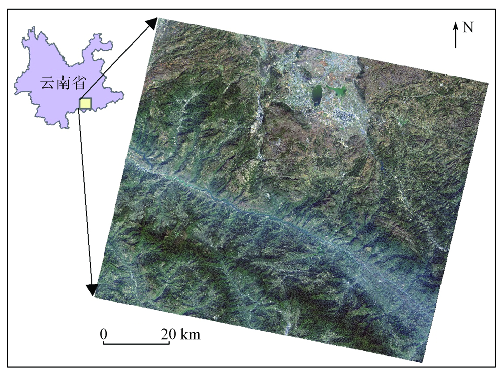
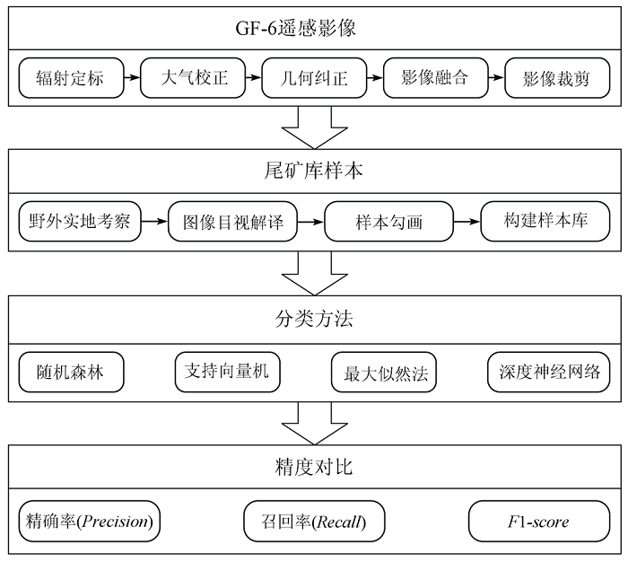
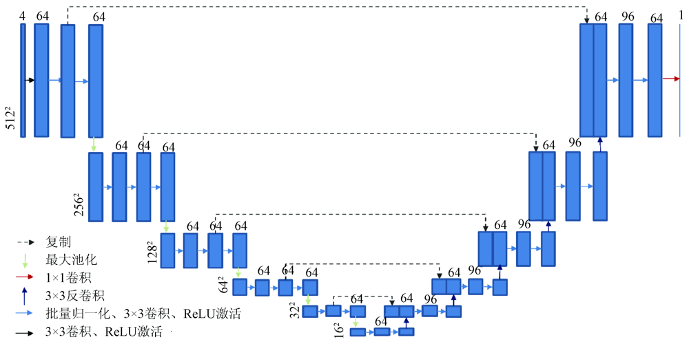
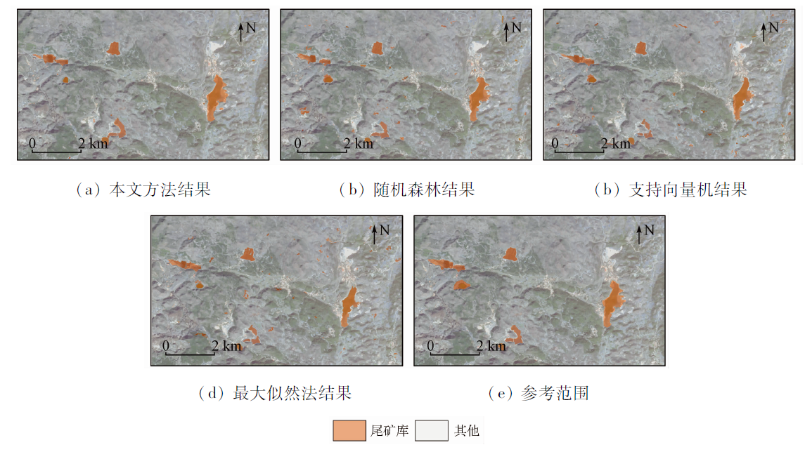
It is of great significance for the monitoring and supervision of tailing ponds in China to realize the rapid recognition of the spatial scopes of tailing ponds using the remote sensing technique. Based on the U-Net framework, this paper proposes a deep learning-based intelligent recognition method of the spatial ranges of tailing ponds using the remote sensing technique. The method proposed was verified in Honghe Hani and Yi Autonomous Prefecture in Yunnan Province using Chinese GF-6 satellite images. The results show that the precision, recall rate, and F1-score of the method were 0.874, 0.843, and 0.858, respectively, which were significantly better than those obtained using the methods of random forest, support vector machine, and maximum likelihood. Furthermore, the time consumption of the new method kept the same order of magnitude as that of the three methods. Therefore, the method proposed in this study has a broad application prospect in the rapid monitoring of the spatial scopes of tailing ponds in China.
张成业, 邢江河, 李军, 桑潇. 基于U-Net网络和GF-6影像的尾矿库空间范围识别[J]. 自然资源遥感, 2021, 33(4): 252-257.
ZHANG Chengye, XING Jianghe, LI Jun, SANG Xiao. Recognition of the spatial scopes of tailing ponds based on U-Net and GF-6 images. Remote Sensing for Natural Resources, 2021, 33(4): 252-257.
Wo T S, Wang Y S, Xiao C B, et al. Manual of tailings pond[M]. Beijing: Metallurgical Industry Press, 2013:1-13.
[2]
Rotta S, Henrique L, Alcantara E, et al. The 2019 Brumadinho tailings dam collapse:Possible cause and impacts of the worst human and environmental disaster in Brazil[J]. International Journal of Applied Earth Observation and Geoinformation, 2020,90:102119.
doi: 10.1016/j.jag.2020.102119
Hao L N, Zhang Z, He W X, et al. Tailings reservoir recognition factors of the high resolution remote sensing image in southeastern of Hubei[J]. Remote Sensing for Land and Resources, 2012,24(3):154-158.doi: 10.6046/gtzyyg.2012.03.27.
doi: 10.6046/gtzyyg.2012.03.27
[4]
Ma B D, Chen Y T, Zhang S, et al. Remote sensing extraction method of tailings ponds in ultra-low-grade iron mining area based on spectral characteristics and texture entropy[J]. Entropy, 2018,20(5):345.
doi: 10.3390/e20050345
[5]
Hao L N, Zhang Z, Yang X X. Mine tailing extraction indexes and model using remote-sensing images in southeast Hubei Province[J]. Environmental Earth Sciences, 2019,78(15):493.
doi: 10.1007/s12665-019-8439-1
Cao L J, Wu B, Wang J H, et al. Object-oriented information extraction and analysis of the iron tailings with GF-1 remote sensing image[J]. Geomatics & Spatial Information Technology, 2019,42(4):98-101.
[7]
Fuentes M, Millard K, Laurin E. Big geospatial data analysis for Canada’s air pollutant emissions inventory (APEI):Using google earth engine to estimate particulate matter from exposed mine disturbance areas[J]. Giscience & Remote Sensing, 2019,57(2):245-257.
Wang L T. Research on application of support vector machine combined with object oriented method for tailing pond extraction[D]. Beijing:China University of Geosciences (Beijing), 2018.
[9]
Orimoloye I R, Ololade O O. Spatial evaluation of land-use dynamics in gold mining area using remote sensing and GIS technology[J]. International Journal of Environmental Science and Technology, 2020,17(11):4465-4480.
doi: 10.1007/s13762-020-02789-8
Yan K, Shen T, Chen Z C, et al. Automatic extraction of tailing pond based on SSD of deep learning[J]. Journal of University of Chinese Academy of Sciences, 2020,37(3):360-367.
[11]
Li Q T, Chen Z C, Zhang B, et al. Detection of tailings dams using high-resolution satellite imagery and a single shot multibox detector in the Jing-Jin-Ji region,China[J]. Remote Sensing, 2020,12(16).
Wang J W, Liu H J, Guo K. Mineral resource geological survey evaluation model based on a rough set theory:A case study in southeastern Yunnan[J]. Resources Science, 2014,36(8):1608-1617.
Pan H J. Geochemical characteristics and resource environment assessment of tailings from typical metal mines in China[D]. Beijing:China University of Geosciences(Beijing), 2019.
[14]
Yang A X, Zhong B, Hu L F, et al. Radiometric cross-calibration of the wide field view camera onboard GaoFen-6 in multispectral bands[J]. Remote Sensing, 2020,12(6):1037.
doi: 10.3390/rs12061037
[15]
杨可明. 遥感原理与应用[M]. 北京: 中国矿业大学出版社, 2016:231-234.
Yang K M. Remote sensing principle and applications[M]. Beijing: China University of Mining and Technology Press, 2016:231-234.
[16]
Ronneberger O, Fischer P, Brox T. U-Net:Convolutional networks for biomedical image segmentation[C]//Medical image Computing and Computer-Assisted Intervention, 2015:234-241.
[17]
Deepsense A. Deep learning for satellite imagery via image segmentation[EB/OL].(2017-4-12)[2021-01-12]. https://deepsense.io/deep-learning-for-satellite-imagery-via-image-segmentation/.
[18]
Zhu X L, Cheng Z Y, Wang S, et al. Coronary angiography image segmentation based on PSPNet[J]. Computer Methods and Programs in Biomedicine, 2020,200(4):105897.
doi: 10.1016/j.cmpb.2020.105897
[19]
Diaz V, Jairo J, Vlaminck M, et al. Solar panel detection within complex backgrounds using thermal images acquired by UAVs[J]. Sensors, 2020,20(21):6219.
doi: 10.3390/s20216219
[20]
Zhang L X, Shen J K, Zhu B J. A research on an improved Unet-based concrete crack detection algorithm[J]. Structural Health Monitoring-An International Journal, 2020: 1475921720940068.
 2021, Vol. 33
  ), 邢江河1, 李军1,2(