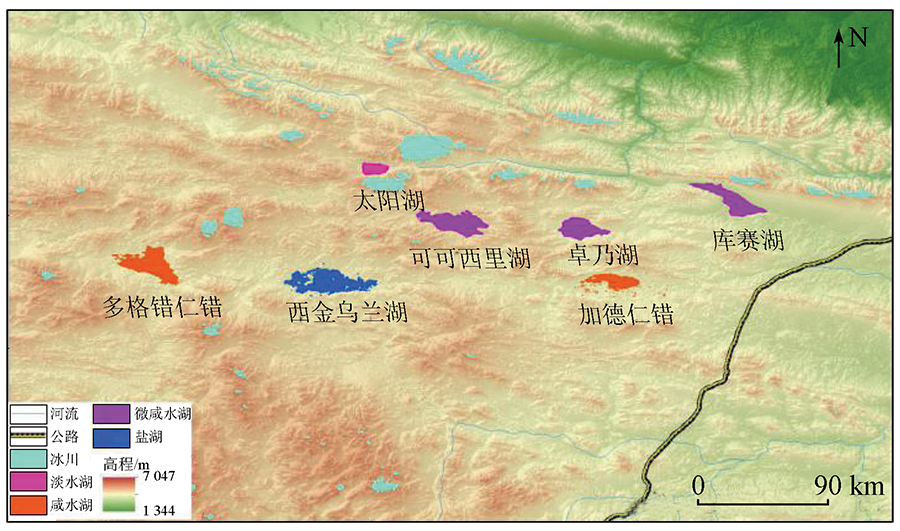
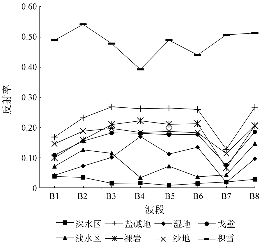
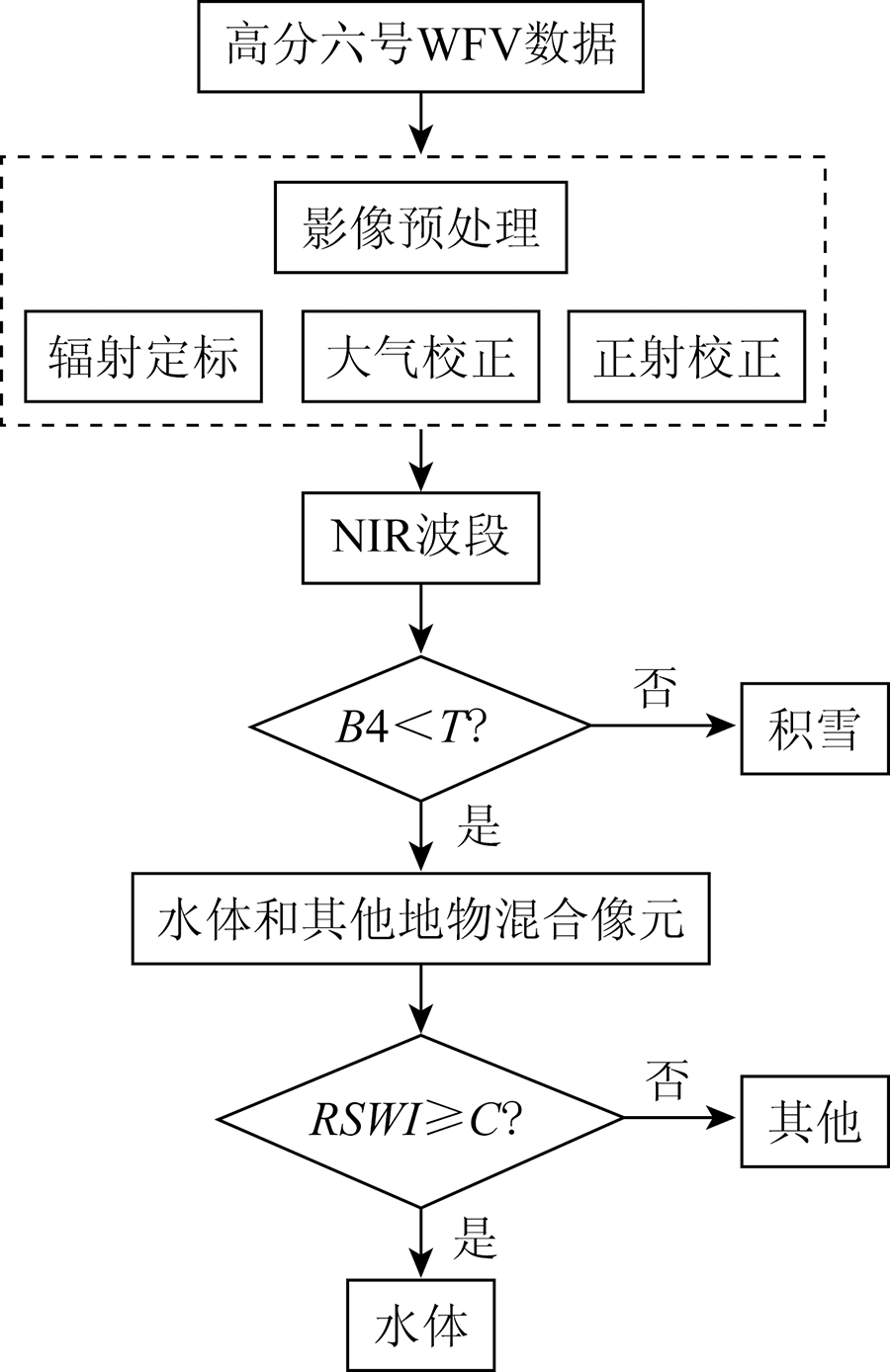
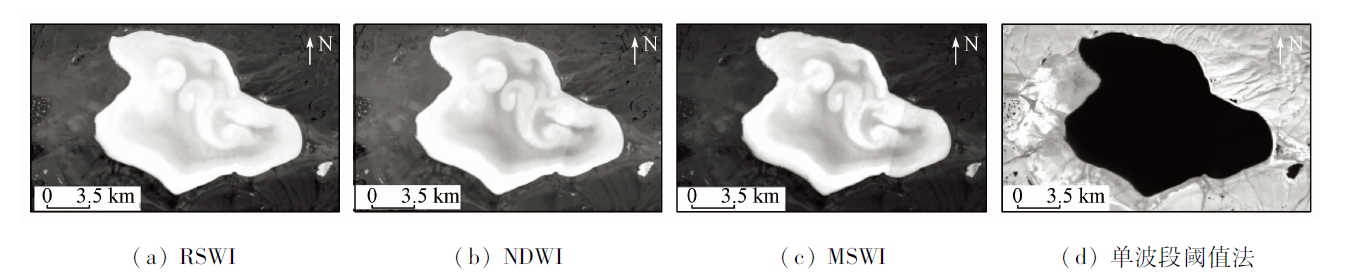
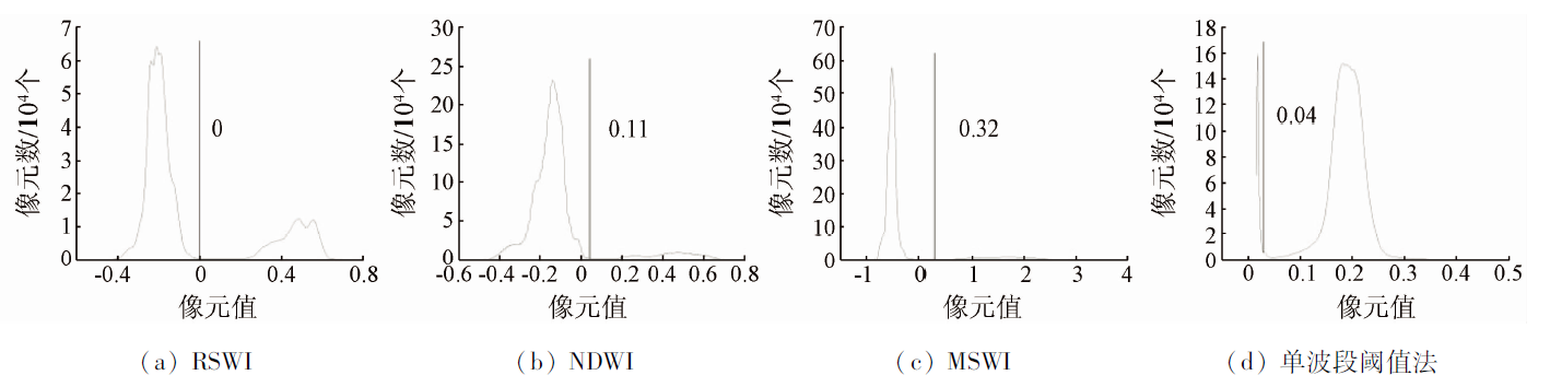
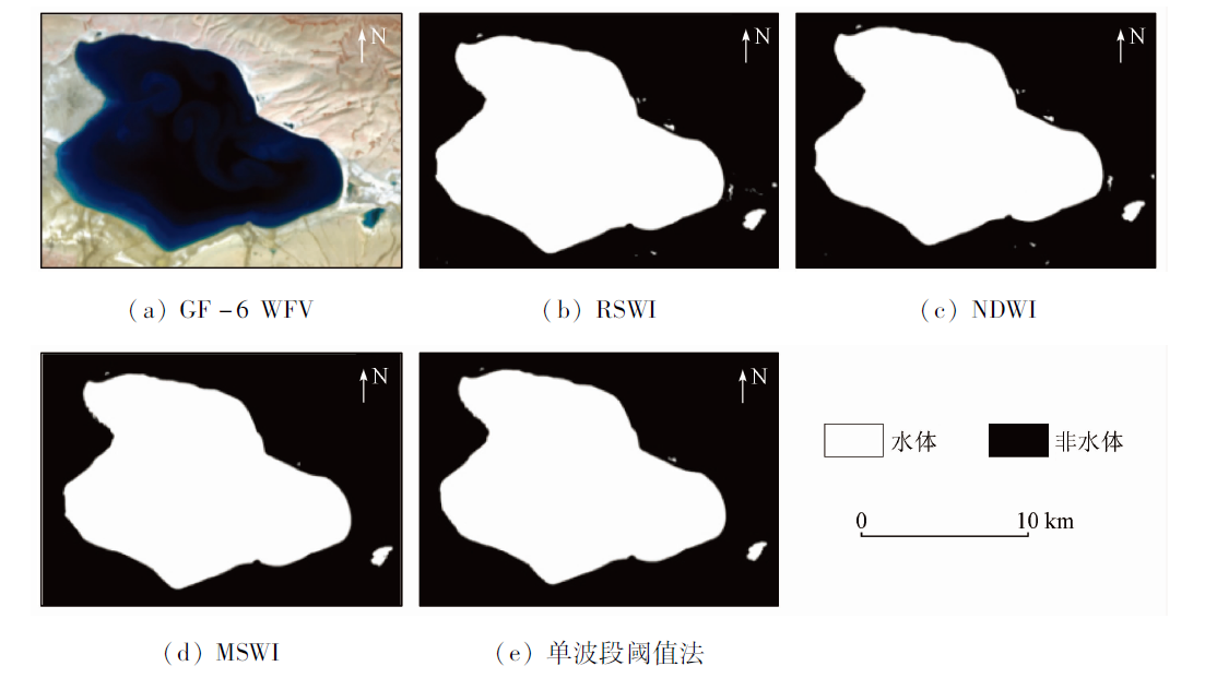
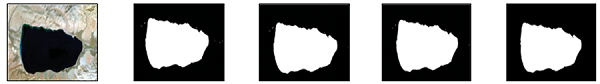
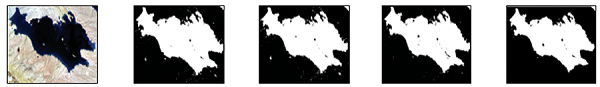
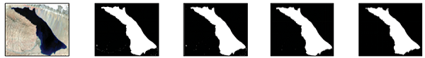
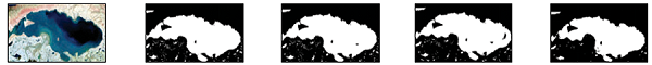
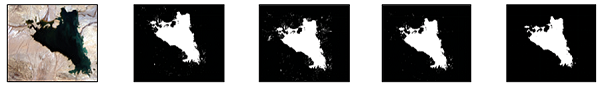
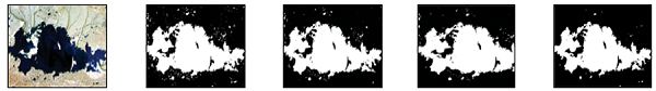
探究基于高分六号水体提取模型,能为水体监测提供新的数据源和技术支撑。首先,基于卓乃湖的高分六号WFV数据分析水体与其他地物反射率的差异,从而构建了一种新的水体指数——红边水体指数(read side water index,RSWI); 然后,利用混淆矩阵生成的总体精度和Kappa系数,分别与归一化差异水体指数、改进的阴影水体指数和单波段阈值法进行了对比精度检验; 最后,选取可可西里地区不同类型面积大于100 km2的6个典型湖泊进行普适性分析。结果表明: 与其他方法相比,RSWI和近红外波段构成的决策树模型有效消除了湖底沉积物对水体的影响,更完整地提取浅水区水体,总体精度达93.78%,Kappa系数为0.87; 另外,RSWI水体模型对不同类型的湖泊具有较好的稳定性和普适性。
Exploration of the water body extraction model based on GF-6 satellite images can provide new data sources and technical support for water body monitoring. First, GF-6 WFV satellite data of Zonag Lake was used to analyze the reflectance difference between water and other ground objects in each band of GF-6 WFV satellite data. Based on this, a novel water index named red side water index (RSWI) was constructed. Then, the overall accuracy and Kappa coefficient generated by the confusion matrix were used to verify RSWI and the other three water extraction models, which include the single-band threshold method, normalized difference water index, and modified shade water index. Finally, six typical lakes with different types of areas larger than 100 km2 in Hoh Xil were selected for analysis of general applicability. The results showed that compared with other methods, the decision tree model composed of RSWI and NIR bands effectively eliminates the influence of lake bottom sediments on water bodies and extracts shallow water bodies more completely, with an overall accuracy of 93.78% and a Kappa coefficient of 0.87. Additionally, it has been found that the stability and general applicability of RSWI are better than those of other water body models with respect to different types of lakes.
王仁军, 李东颖, 刘宝康. 基于高分六号WFV数据的可可西里湖泊水体识别模型[J]. 自然资源遥感, 2022, 34(2): 80-87.
WANG Renjun, LI Dongying, LIU Baokang. A water body identification model for lakes in Hoh Xil based on GF-6 WFV satellite data. Remote Sensing for Natural Resources, 2022, 34(2): 80-87.
Xu R, Zhang Z X, Zhao C Z. Different models used in extraction of lake water body based on MODIS data[J]. Remote Sensing Information, 2015, 30(1):111-118.
Zhu G, Gao H J, Zeng G. Lake change research and reasons analysis in Xinjiang arid regions during the past 35 years[J]. Arid Land Geography, 2015, 38(1):103-110.
Xie C W, Zhang Y X, Liu W H, et al. Environmental changes caused by the outburst of Zonag Lake and the possible outburst mode of Yanhu Lake in the Hoh Xil region[J]. Journal of Glaciology and Geocryology, 2020, 42(4):1344-1352.
La B, Ge S Z M, La B Z M, et al. Variation and reasons of the coverage of Puruogangri glacier and its surrounding lakes during 1992—2014[J]. Arid Land Geography, 2016, 39(4):770-776.
Yao X J, Liu S Y, Li L, et al. Spatial temporal variations of lake area in Hoh Xil region in the past 40 years[J]. Acta Geographica Sinica, 2013, 68(7):886-896.
Liu B K, Li L, Du Y E, et al. Causes of the outburst of Zonag Lake in Hoh Xil,Tibetan Plateau,and its impact on surrounding environment[J]. Journal of Glaciology and Geocryology, 2016, 38(2):305-311.
[8]
Komeil R, Anuar A, Ail S, et al. Water feature extraction and change detection using multitemporal Landsat imagery[J]. Remote Sensing, 2014, 6(5):4173-4189.
doi: 10.3390/rs6054173
[9]
Adrian F, Neil F, Tim D. Comparing Landsat water index methods for automated water classification in eastern Australia[J]. Remote Sensing of Environment, 2016(175):167-182.
Bi H Y, Wang S Y, Zeng J Y, et al. Comparison and analysis of several common water extraction methods based on TM image[J]. Remote Sensing Information, 2012, 27(5):77-82.
Chen P, Zhang Q, Li Q. Comparative analysis of several commonly used water extraction method based on FY3A/MERSI imagery[J]. Arid Land Geography, 2015, 38(4):770-778.
Yang Y, Ruan R Z. Extraction of plain lake water body based on TM imagery[J]. Remote Sensing Information, 2010, 25(3):60-64.
[13]
McFeeters S K. The use of the normalized difference water index( NDWI) in the delineation of open water feature[J]. International Journal of Remote Sensing, 1996, 17(7):1425-1432.
doi: 10.1080/01431169608948714
Xu H Q. A study on information extraction of water body with the modified normalized difference water index(MNDWI)[J]. Journal of Remote Sensing, 2005, 9(5):589-595.
Chen W Q, Ding J L, Li Y H, et al. Extraction of water information based on China-made GF-1 remote sense image[J]. Resources Science, 2015, 37(6):1166-1172.
Wang J J, Ding J L, Zhang C, et al. Method of water information extraction by improved SWI based on GF-1 satellite image[J]. Remote Sensing for Land and Resources, 2017, 29(1):29-35.doi: 10.6046/gtzyyg.2017.01.05.
doi: 10.6046/gtzyyg.2017.01.05
Wang X B, Xie S P, Du J K. Water index formulation and its effectiveness research on the complicated surface water surroundings[J]. Journal of Remote Sensing, 2018, 22(2):360-372.
Wang L, Xie H B, Wen G C, et al. A study on water information extraction method of cyanobacteria lake based on Landsat8[J]. Remote Sensing for Land and Resources, 2020, 32(4):130-136.doi: 10.6046/gtzyyg.2019351.
doi: 10.6046/gtzyyg.2019351
Li L, Yao X J, Li F X, et al. Stduy on monitoring lake water level changes in the Hoh Xil region based on ICESat/GLAS data[J]. Chinese Journal of Agricultural Resources and Regional Planning, 2019, 40(3):45-52,60.
 2022, Vol. 34
  ), 李东颖, 刘宝康(