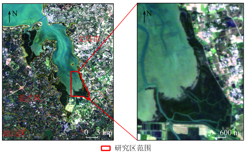
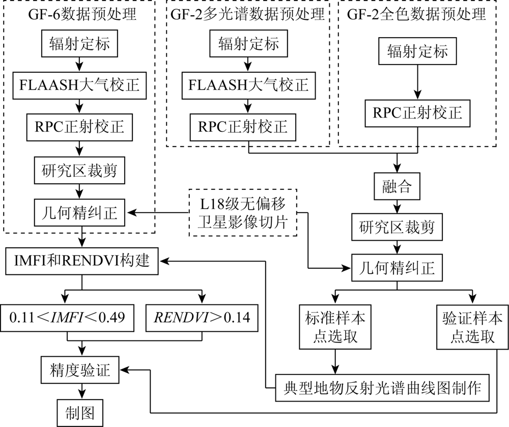
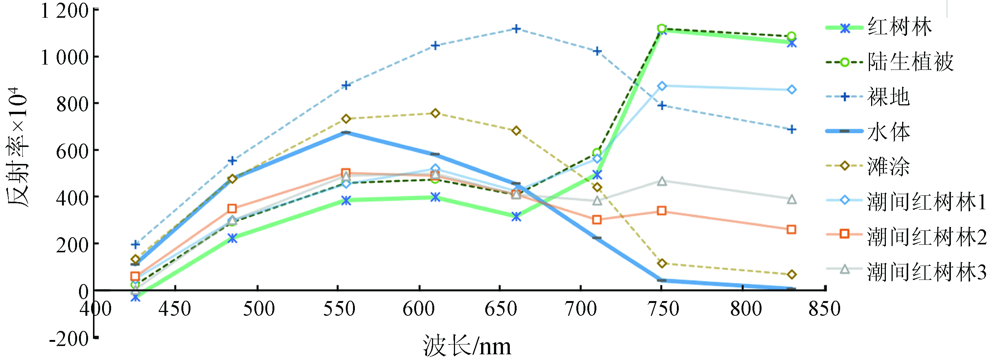
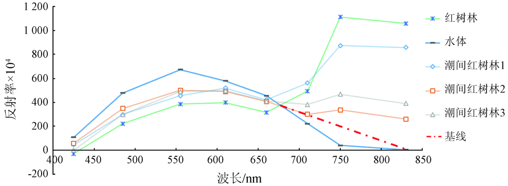
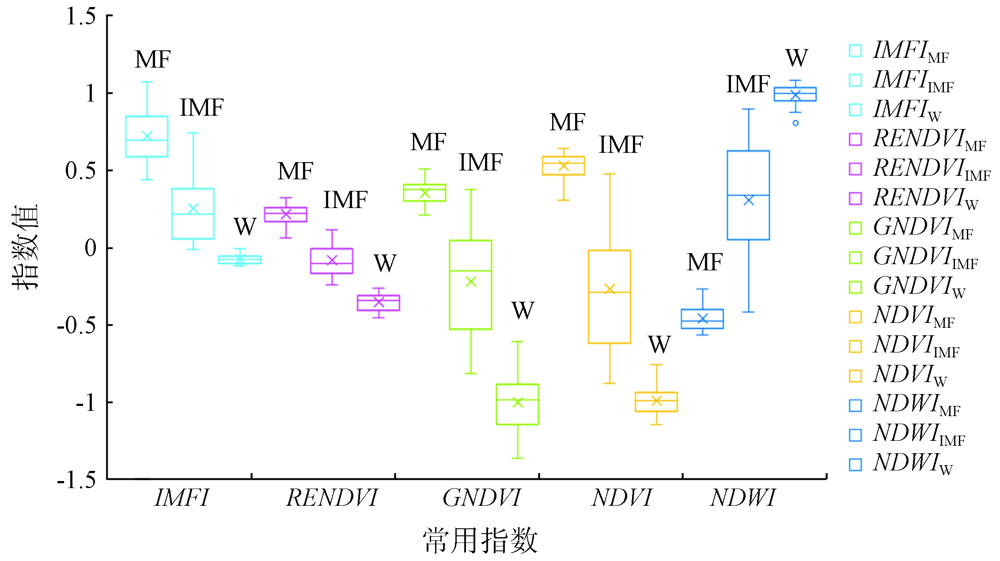
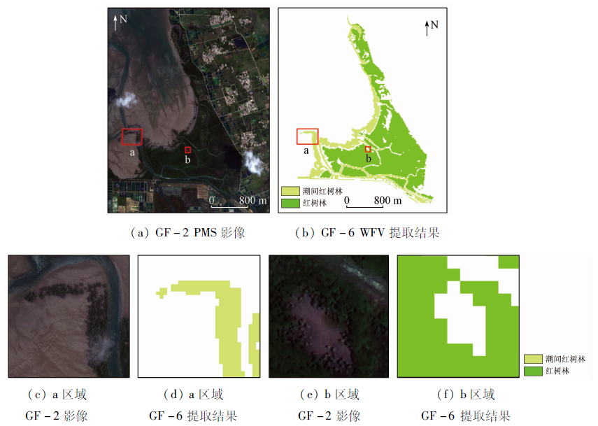
Mangrove forests are periodically inundated by tidal water. This characteristic opens up an opportunity but also poses a challenge for the information extraction of mangrove forests using remote sensing technology. To explore the contribution of the red-edge band of GF-6 satellite data in information extraction of mangrove forests under the condition of random tides, this study investigated the southeastern Dongzhaigang area-the largest mangrove forest area in Hainan Province and obtained standard samples using the GF-2 satellite data. The reflectance spectral curves of typical surface features were constructed based on the standard samples and the GF-6 satellite data. Then, a baseline was established based on the bands strongly absorbed by vegetation, and the intertidal mangrove forest index (IMFI) applicable to the GF-6 satellite data was defined using the average reflectance of bands above the baseline. Meanwhile, the red-edge normalized difference vegetation index (RENDVI) was also established. The two indices were compared with commonly used indices, such as the normalized difference vegetation index (NDVI) and the normalized difference water index (NDWI), using box-whisker plots. Then, using the decision tree model constructed based on IMFI and RENDVI, information on typical mangrove forest in the study area were extracted. The precision of the extraction results was verified through comparison with visual interpretation results of the samples extracted from the GF-2 satellite data. The results show that: ① Because mangrove forests are periodically inundated by tidal water, the reflectance spectral curves of intertidal mangrove forests were relatively scattered between the standard spectral curves of water bodies and mangrove forests; ② IMFI and RENDVI can reflect the differences in the reflectance spectra of the red-edge and near-infrared bands and thus effectively separated the intertidal mangrove forests, mangrove forests, and water bodies; ③ The decision tree model constructed based on IMFI and RENDVI can effectively extract the distribution information of the mangrove forests, with an overall accuracy of 0.95 and a Kappa coefficient of 0.90. The introduction of the red-edge band plays an important role in the information extraction of mangrove forests and has great potential for application. This study can be used as a reference for the ecological applications of red-edge data from domestic satellites.
许青云, 李莹, 谭靖, 张哲. 基于高分六号卫星数据的红树林提取方法[J]. 自然资源遥感, 2023, 35(1): 41-48.
XU Qingyun, LI Ying, TAN Jing, ZHANG Zhe. Information extraction method of mangrove forests based on GF-6 data. Remote Sensing for Natural Resources, 2023, 35(1): 41-48.
Zhang Q M, Sui S Z. The mangrove wetland resources and their conservation in China[J]. Journal of Natural Resources, 2001, 16(1):28-36.
doi: 10.11849/zrzyxb.2001.01.005
Zhang H, Wang S X, Zhou Y, et al. Comparison of different metho-ds of mangrove extraction from multi-source remote sensing images[J]. Wetland Science, 2015, 13(2):145-152.
Dan X Q, Liao B W, Wu Z B, et al. Resources,conservation status and main threats of mangrove wetlands in China[J]. Ecology and Environmental Sciences, 2016, 25(7):1237-1243.
[4]
Heumann B W. An object-based classification of mangroves using a hybrid decision tree-support vector machine approach[J]. Remote Sensing, 2011, 3(11):2440-2460.
doi: 10.3390/rs3112440
[5]
Cardenas N Y, Joyce K E, Maier S W. Monitoring mangrove forests: Are we taking full advantage of technology?[J]. International Journal of Applied Earth Observation and Geoinformation, 2017, 63(7):1-14.
doi: 10.1016/j.jag.2017.07.004
[6]
Heumann B W. Satellite remote sensing of mangrove forests: Recent advances and future opportunities[J]. Progress in Physical Geography: Earth and Environment, 2011, 35(1):87-108.
doi: 10.1177/0309133310385371
[7]
Wang T, Zhang H S, Lin H, et al. Textural-spectral feature-based species classification of mangroves in Mai Po Nature Reserve from Worldview-3 imagery[J]. Remote Sensing, 2016, 8(1):24.
doi: 10.3390/rs8010024
[8]
Mondal P, Liu X, Fatoyinbo T E, et al. Evaluating combinations of Sentinel-2 data and machine-learning algorithms for mangrove mapping in West Africa[J]. Remote Sensing, 2019, 11(24):2928.
doi: 10.3390/rs11242928
[9]
蒙良莉. 基于哨兵多源遥感数据的红树林信息提取算法研究[D]. 南宁: 南宁师范大学, 2020.
Meng L L. Mangrove information extraction algorithm based on multi-source remote sensing data of sentinel[D]. Nanning: Nanning Normal University, 2020.
[10]
Jia M M, Wang Z M, Wang C, et al. A new vegetation index to detect periodically submerged mangrove forest using single-tide Sentinel-2 imagery[J]. Remote Sensing, 2019, 11(17):2043.
doi: 10.3390/rs11172043
[11]
Farid M F. Comparison of different vegetation indices for assessing mangrove density using Sentinel-2 imagery[J]. International Journal of GEOMATE, 2018, 14(45):42-51.
[12]
Baloloy A B, Blanco A C, Ana R R C S, et al. Development and application of a new mangrove vegetation index (MVI) for rapid and accurate mangrove mapping[J]. ISPRS Journal of Photogrammetry and Remote Sensing, 2020, 166:95-117.
doi: 10.1016/j.isprsjprs.2020.06.001
[13]
Manna S, Raychaudhuri B. Retrieval of leaf area index and stress conditions for Sundarban mangroves using Sentinel-2 data[J]. International Journal of Remote Sensing, 2020, 41(3):1019-1039.
doi: 10.1080/01431161.2019.1655174
Xu F, Zhang Y, Zhai L, et al. Extraction method of intertidal mangrove by using Sentinel-2 images[J]. Bulletin of Surveying and Mapping, 2020(2):49-54.
[15]
Filella I, Penuelas J. The red edge position and shape as indicators of plant chlorophyll content,biomass and hydric status[J]. International Journal of Remote Sensing, 1994, 15(7):1459-1470.
doi: 10.1080/01431169408954177
Wang L J, Guo Y, Wang L G, et al. Impact of red-edge waveband of GF6 satellite on classification accuracy of spring crops[J]. Journal of Henan Agricultural Sciences, 2020, 49(6):165-173.
Liang J, Zheng Z W, Xia S T, et al. Crop recognition and evaluation using red edge features of GF-6 satellite[J]. Journal of Remote Sensing, 2020, 24(10):1168-1179.
Yao B M, Wang L M, Wang D, et al. Improvement of the accuracy of crop recognition by the newly added spectrum of the GF-6 satellite WFV[J]. Satellite Application, 2020(12):31-34.
Zhang Q Y, Li Z, Xia C Z, et al. Tree species classification based on the new bands of GF-6 remote sensing satellite[J]. Journal of Geo-Information Science, 2019, 21(10):1619-1628.
[20]
Xia Q, Qin C Z, Li H, et al. Mapping mangrove forests based on multi-tidal high-resolution satellite imagery[J]. Remote Sensing, 2018, 10(9):1343.
doi: 10.3390/rs10091343
[21]
Zhang X H, Treitz P M, Chen D M, et al. Mapping mangrove forests using multi-tidal remotely-sensed data and a decision-tree-based procedure[J]. International Journal of Applied Earth Observation and Geoinformation, 2017, 62:201-214.
doi: 10.1016/j.jag.2017.06.010
[22]
Rogers K, Lymburner L, Salum R, et al. Mapping of mangrove extent and zonation using high and low tide composites of Landsat data[J]. Hydrobiologia, 2017, 803(1):49-68.
doi: 10.1007/s10750-017-3257-5
[23]
Jia M M, Wang Z M, Zhang Y Z, et al. Landsat-based estimation of mangrove forest loss and restoration in Guangxi Province,China,influenced by human and natural factors[J]. IEEE Journal of Selected Topics in Applied Earth Observations and Remote Sensing, 2015, 8(1):311-323.
doi: 10.1109/JSTARS.4609443
[24]
Jia M M, Wang Z M, Zhang Y Z, et al. Monitoring loss and recovery of mangrove forests during 42 years: The achievements of mangrove conservation in China[J]. International Journal of Applied Earth Observation and Geoinformation, 2018, 73:535-545.
doi: 10.1016/j.jag.2018.07.025
Zhang W, Chen Z H, Wang J K. Monitoring the areal variation of mangrove in Beibu Gulf coast of Guangxi China with remote sensing data[J]. Journal of Guangxi University (Natural Science Edition), 2015, 40(6):1570-1576.
[27]
Pettorelli N, Ryan S, Mueller T, et al. The normalized difference vegetation index (NDVI):Unforeseen successes in animal ecology[J]. Climate Research, 2011, 46(1):15-27.
doi: 10.3354/cr00936
[28]
Gao B C. NDWI-A normalized difference water index for remote sensing of vegetation liquid water from space[J]. Remote Sensing of Environment, 1996, 58(3):257-266.
doi: 10.1016/S0034-4257(96)00067-3
[29]
Gitelson A A, Merzlyak M N. Remote estimation of chlorophyll content in higher plant leaves[J]. International Journal of Remote Sensing, 1997, 18(12):2691-2697.
doi: 10.1080/014311697217558
[30]
Gower J, Hu C M, Borstad G, et al. Ocean color satellites show extensive lines of floating sargassum in the Gulf of Mexico[J]. IEEE Transactions on Geoscience and Remote Sensing, 2006, 44(12):3619-3625.
doi: 10.1109/TGRS.2006.882258
[31]
Hu C M. A novel ocean color index to detect floating algae in the global oceans[J]. Remote Sensing of Environment, 2009, 113(10):2118-2129.
doi: 10.1016/j.rse.2009.05.012
[32]
Gao B C, Li R R. FVI-A floating vegetation index formed with three near-IR channels in the 1.0-1.24 μm spectral range for the detection of vegetation floating over water surfaces[J]. Remote Sensing, 2018, 10(9):1421.
doi: 10.3390/rs10091421
 2023, Vol. 35
  ), 李莹, 谭靖, 张哲