Please wait a minute...
 
自然资源遥感  2022, Vol. 34 Issue (3): 235-239    DOI: 10.6046/zrzyyg.2021292
  技术应用 本期目录 | 过刊浏览 | 高级检索 |
污染地块土地治理与开发利用遥感监测——以浙江省风险管控与修复名录地块为例
佟晶1(), 杨金中1, 杜鑫2, 杜晓敏1, 李春博2, 安娜1
1.中国自然资源航空物探遥感中心,北京 100083
2.中国地质大学(北京)土地科学技术学院,北京 100083
Remote sensing-based monitoring of the treatment and redevelopment of the brownfields: A case study of brownfields in the risk control and rehabilitation list of Zhejiang Province
TONG Jing1(), YANG Jinzhong1, DU Xin2, DU Xiaomin1, LI Chunbo2, AN Na1
1. China Aero Geophysical Survey and Remote Sensing Center for Natural Resources, Beijing 100083, China
2. School of Land Science and Technology, China University of Geosciences(Beijing), Beijing 100083, China
全文: PDF(2104 KB)   HTML  
输出: BibTeX | EndNote (RIS)      
摘要 

为深入挖掘遥感监测技术对污染地块风险管控、土壤修复治理及开发建设活动等土地利用现状的监测能力,抽取浙江省纳入全国污染土壤信息管理系统中风险管控与修复名录的98个污染地块,利用其历史期和监测期2个时相的国产高分辨率遥感卫星影像数据,基于ArcGIS平台,通过影像数据处理和人机交互解译,对污染地块的土地利用现状变化开展遥感监测; 结合污染地块调查、风险评估、管控与修复效果评估报告及污染地块的属性信息,对监测结果进行统计分析。结果表明: 利用遥感监测技术可以快速查明污染地块实施风险管控、土壤修复以及开发建设活动情况,及时掌握风险管控与修复名录污染地块的土地利用现状及发展动态、存在问题,为地方相关部门开展污染地块再开发利用准入管理工作提供技术支撑和依据。

服务
把本文推荐给朋友
加入引用管理器
E-mail Alert
RSS
作者相关文章
佟晶
杨金中
杜鑫
杜晓敏
李春博
安娜
关键词 污染地块风险管控与修复治理再开发利用遥感监测    
Abstract

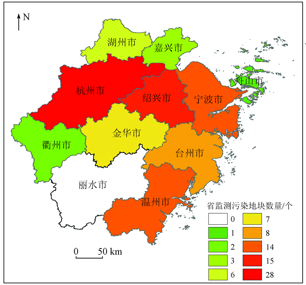
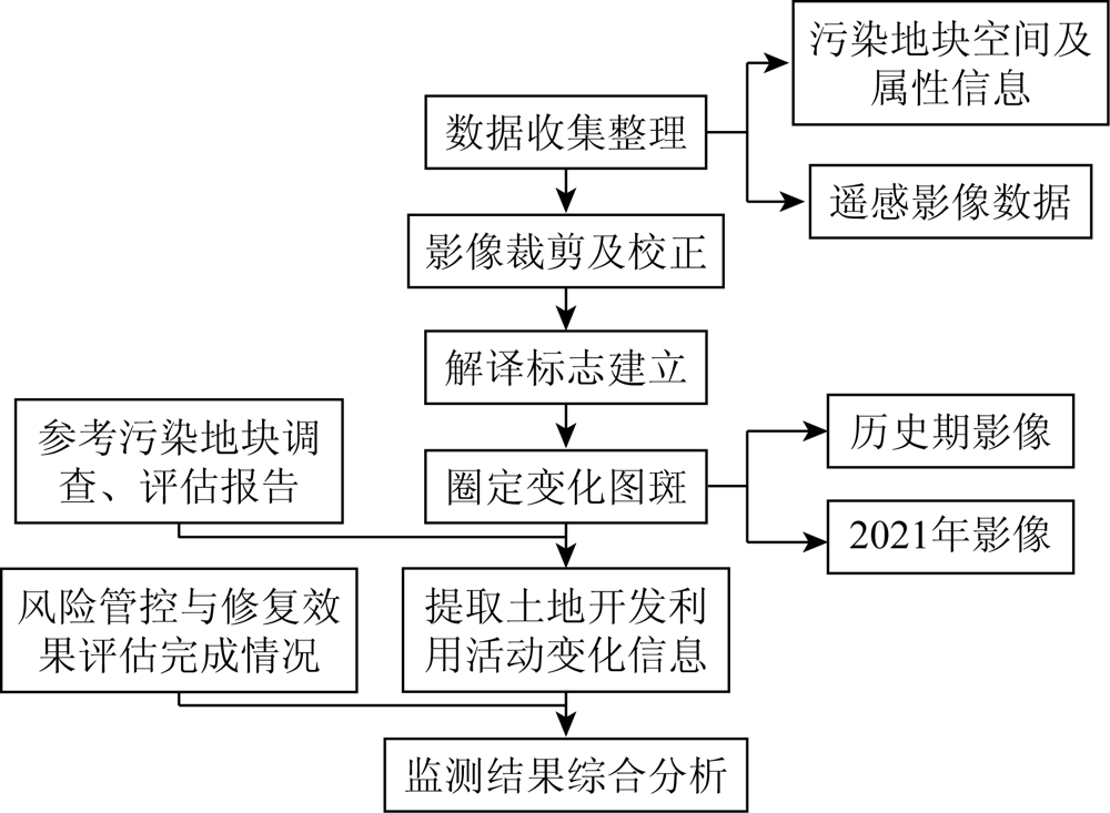
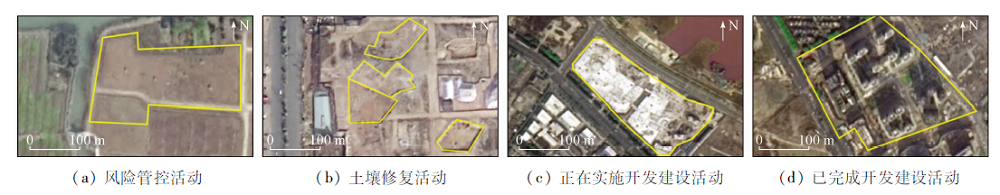
This study aims to further tap the remote sensing monitoring technique in monitoring the current land use of brownfields, including risk control, soil remediation, and development and construction. Firstly, this study selected 98 brownfields of Zhejiang Province that have been included in the risk control and remediation list in the national contaminated soil information management system. Then, using images of the historical period and the monitoring period from the domestic high-resolution remote sensing satellite, this study conducted the remote sensing monitoring of changes in land use through image processing and human-computer interactive interpretation on the ArcGIS platform. Finally, this study made statistics of the monitoring results by combining the reports on the surveys, risk assessment, and control and remediation effects of the brownfields, as well as the attribute information of the brownfields. The results show that the monitoring based on the remote sensing technique can be used to quickly identify the implementation of risk control, soil remediation, and development and construction of the brownfields and timely grasp the current status, dynamic trends, and issues of the use of brownfields included in the risk control and rehabilitation list. This study will provide technical support and bases for relevant public departments to carry out the access management of the redevelopment of brownfields.

Key wordsbrownfield    risk control and remediation    redevelopment    remote sensing monitoring
收稿日期: 2021-09-16      出版日期: 2022-09-21
ZTFLH:  TP79  
基金资助:中国地质调查局地质调查项目“重点地区和特殊地块用途管制监测评价”(DD20211276)
作者简介: 佟 晶(1984-),女,博士,高级工程师,现从事国土空间用途管制研究工作。Email: tongjing84@163.com
引用本文:   
佟晶, 杨金中, 杜鑫, 杜晓敏, 李春博, 安娜. 污染地块土地治理与开发利用遥感监测——以浙江省风险管控与修复名录地块为例[J]. 自然资源遥感, 2022, 34(3): 235-239.
TONG Jing, YANG Jinzhong, DU Xin, DU Xiaomin, LI Chunbo, AN Na. Remote sensing-based monitoring of the treatment and redevelopment of the brownfields: A case study of brownfields in the risk control and rehabilitation list of Zhejiang Province. Remote Sensing for Natural Resources, 2022, 34(3): 235-239.
链接本文:  
https://www.gtzyyg.com/CN/10.6046/zrzyyg.2021292      或      https://www.gtzyyg.com/CN/Y2022/V34/I3/235
Fig.1  浙江省风险管控与修复名录监测污染地块区域分布图
Fig.2  污染地块土地再开发利用遥感监测技术流程图
Fig.3  污染地块解译标志图
开发活动
迹象类型
活动描述 影像色调 影像形状
风险管控活动 对地块污染源移除、布设防尘、阻隔设施等 一般为土黄色、绿色,少量有黑色、白色 风险管控区域边界形状较规则
土壤修复活动 在地块实施的土壤修复有关的活动,如搭建临时建筑、土壤开挖、土壤临时堆存等 土黄色、绿色,根据土壤修复堆存时间会有所变化 土壤修复区域边界较清晰、形状不规则
正在实施开发建设活动 地块上有其他用途的建设活动,例如土地平整、打地基、房屋建设、绿化等活动 土黄色、灰色、白色 正在实施开发建设活动区域边界清晰
已完成开发建设活动 地块开发为住宅、公共管理与公共服务用地的开发建设活动结束 主要为灰色、黑色,部分为白色 已完成开发建设活动区域边界清晰且形状规则
Tab.1  污染地块土地治理与开发利用活动迹象解译识别标志
Fig.4  解译结果野外实地验证
市级行
政区
污染地块
总面积
正在实施风险管控
与土壤修复面积
完成风险管控与土
壤修复面积
杭州市 2 109 814.38 467 335.40 1 381 092.67
湖州市 81 292.37 75 306.14 5 986.24
嘉兴市 167 572.81 36 205.28 131 367.54
金华市 193 009.95 184 640.00 0.00
市级行
政区
污染地块
总面积
正在实施风险管控
与土壤修复面积
完成风险管控与土
壤修复面积
宁波市 610 895.33 7 455.57 250 328.48
衢州市 56 606.12 56 606.12 0.00
绍兴市 1 045 219.76 56 202.41 609 544.35
台州市 435 750.21 374 416.10 16 339.01
温州市 909 621.67 143 213.95 315 708.72
舟山市 34 229.46 0.00 0.00
合计 5 644 012.05 1 401 380.96 2 710 367.02
Tab.2  浙江省各市风险管控与修复名录地块的风险管控与修复情况统计列表
市级行
政区
开发建设活
动总面积
正在实施开发建
设活动面积
已完成开发建设
活动面积
杭州市 1 625 562.49 1 155 102.77 470 459.71
湖州市 5 986.24 0.00 5 986.24
嘉兴市 131 367.54 131367.54 0.00
金华市 8 369.95 8 369.95 0.00
宁波市 603 439.76 67 155.19 536 284.56
绍兴市 989 017.35 138 290.96 850 726.39
台州市 61 334.10 0.00 61 334.10
温州市 766 407.72 287 114.00 479 293.71
舟山市 34 229.46 0.00 34 229.46
合计 4 225 714.59 1 787 400.41 2 438 314.18
Tab.3  浙江省各市风险管控与修复名录地块的开发建设活动统计列表
[1] 金远亮, 侯德义, 田莉, 等. 基于用地规划的污染地块修复多目标优化研究[J]. 中国环境科学, 2021, 41(2):787-800.
Jin Y L, Hou D Y, Tian L, et al. Multi-objective optimization for brownfield remediation on the basis of land use planning[J]. China Environmental Science, 2021, 41(2):787-800.
[2] Hong Y, Xianjin H, R T J, et al. China’s soil pollution:Urban brownfields[J]. Science(New York), 2014, 344(6185).
[3] 崔轩, 李志涛, 王夏晖, 等. 污染地块再开发利用准入管理机制探讨[J]. 环境污染与防治, 2019, 41(1):1-5.
Cui X, Li Z T, Wang X H, et al. Study on the admittance management mechanism for the redevelopment of contaminated sites[J]. Environmental Pollution & Control, 2019, 41(1):1-5.
[4] 代秀龙, 林善泉. 城市旧机场地区土地再开发规划策略——以湛江机场片区概念性规划为例[J]. 规划师, 2017, 33(6):94-99.
Dai X L, Lin S Q. Old airport land redevelopment planning:A Zhanjiang case[J]. Planners, 2017, 33(6):94-99.
[5] 付佩, 刘兴姝, 夏莺. 中英棕地治理对土地再开发利用的启示[J]. 西部大开发(土地开发工程研究), 2019, 4(5):57-61.
Fu P, Liu X Z, Xia Y. Enlightenment of brownfield management in China and UK on the redevelopment and reuse of land[J]. Land Development and Engineering Research, 2019, 4(5):57-61.
[6] 李志涛. 不同污染地块,如何选用处置策略?——对几个具体案例的风险管控和治理修复实践分析[J]. 中国生态文明, 2020, 2(3):76-77.
Li Z T. How to choose a disposal strategy for different brownfields? ——An analysis of risk management and remediation practices in several specific cases[J]. China’s Ecological Civilization, 2020, 2(3):76-77.
[7] 孙海波, 谢辉, 陈嘉, 等. 污染土地再开发中的环境风险与责任[J]. 上海国土资源, 2017, 38(1):79-82,86.
Sun H T, Xie H, Chen J, et al. Environmental risk and liability of contaminate land redevelopment[J]. Shanghai Land & Resources, 2017, 38(1):79-82,86.
[8] 吴继业. 工业污染场地再开发利用的思考与建议——以温州市龙湾区为例[J]. 环境保护与循环经济杂志, 2017, 38(1):79-82,86.
Wu J Y. Recommendation on the contaminate land redevelopment in Longwan District of Wenzhou City[J]. Liaoning Urban Rural Environ Sci Technol, 2017, 38(1):79-82,86.
[9] 熊杰. 浅谈工业企业污染地块的修复与再开发[J]. 智能城市, 2019, 5(13):156-157.
Xiong J. An introduction to the remediation and redevelopment of contaminated land in industrial enterprises[J]. Intelligent City, 2019, 5(13):156-157.
[10] 赵沁娜. 城市土地置换过程中土壤污染风险评价与风险管理研究[D]. 上海: 华东师范大学, 2006.
Zhao Q N. Study on the risk assessment and risk management of soil pollution during urban band replacement[D]. Shanghai: East China Normal University, 2006.
[11] 赵沁娜, 范利军. 多元利益视角下的城市“棕色土地”再开发管理[J]. 城市发展研究, 2010, 17(5):98-101.
Zhao Q N, Fan L J. Research on the management of urban brownfield’s redevelopment from stakeholders’ perspective[J]. Urban Development Studies, 2010, 17(5):98-101.
[12] 张俊丽, 王芳, 余勤飞, 等. 工业企业场地再开发的多部门联合监管机制探讨[J]. 环境污染与防治, 2014, 36(12):1-5.
Zhang J L, Wang F, Yu Q F, et al. Study on multi-department joint supervision mechanism for redevelopment of industrial contaminated sites[J]. Environmental Pollution & Control, 2014, 36(12):1-5.
[13] O’connor D, Hou D. Sustainable remediation and revival of brownfields[J]. Science of the Total Environment, 2020, 741:140475.
doi: 10.1016/j.scitotenv.2020.140475
[14] Popescu G, Pătrăşcoiu R. Brownfield sites-between abandonment and redevelopment case study:Craiova City[J]. Human Geographies:Journal of Studies and Research in Human Geography, 2012, 6(1):91-97.
doi: 10.5719/hgeo.2012.61.91
[15] Wu Q, Zhang X, Liu C, et al. The de-industrialization,re-suburbanization and health risks of brownfield land reuse:Case study of a toxic soil event in Changzhou,China[J]. Land Use Policy, 2018, 74:187-194.
doi: 10.1016/j.landusepol.2017.07.039
[16] 王海庆, 武明德, 刘琼, 等. 山西某地矿业开发占用土地状况遥感监测[J]. 国土资源遥感, 2018, 30(1):116-120.doi: 10.6046/gtzyyg.2018.01.16.
doi: 10.6046/gtzyyg.2018.01.16
Wang H Q, Wu M D, Liu Q, et al. Remote sensing monitoring of mining land in a certain area of Shanxi Province[J]. Remote Sensing for Land and Resources, 2018, 30(1):116-120.doi: 10.6046/gtzyyg.2018.01.16.
doi: 10.6046/gtzyyg.2018.01.16
[1] 于航, 安娜, 汪洁, 邢宇, 许文佳, 步凡, 王晓红, 杨金中. 黔西南采煤塌陷区高分遥感动态监测——以六盘水市煤矿采空塌陷区为例[J]. 自然资源遥感, 2023, 35(3): 310-318.
[2] 王娟, 王志红, 张建国, 初娜, 李斯, 尹展. 河南省国家级自然保护区人类活动遥感监测及其影响强度评价[J]. 自然资源遥感, 2022, 34(4): 235-242.
[3] 辛荣芳, 李宗仁, 张焜, 张兴, 黄丽, 刘宝山. 青海省湟水流域地质灾害动态变化遥感监测[J]. 自然资源遥感, 2022, 34(4): 254-261.
[4] 李星佑, 张飞, 王筝. 土壤盐渍化遥感监测模型构建方法现状与发展趋势[J]. 自然资源遥感, 2022, 34(4): 11-21.
[5] 陈艳英, 马鑫程, 徐彦平, 王颖, 汪艳波. 地形及NDVI在林火遥感监测二次识别中应用的方法探讨[J]. 自然资源遥感, 2022, 34(3): 88-96.
[6] 董双发, 范晓, 石海岗, 许莉萍, 章新益. 基于Landsat8和无人机的福清核电温排水分布研究[J]. 自然资源遥感, 2022, 34(3): 112-120.
[7] 查东平, 蔡海生, 张学玲, 何庆港. 基于多时相Sentinel-1水稻种植范围提取[J]. 自然资源遥感, 2022, 34(3): 184-195.
[8] 左璐, 孙雷刚, 鲁军景, 徐全洪, 刘剑锋, 马晓倩. 基于MODIS的京津冀地区生态质量综合评价及其时空变化监测[J]. 自然资源遥感, 2022, 34(2): 203-214.
[9] 吕品, 熊丽媛, 徐争强, 周学铖. 基于FME的矿山遥感监测矢量数据图属一致性检查方法[J]. 自然资源遥感, 2022, 34(1): 293-298.
[10] 陈栋, 姚维岭. 基于ArcPy与定制ArcToolbox的矿山新增图斑自动编号及方法改进[J]. 国土资源遥感, 2021, 33(2): 262-269.
[11] 刁明光, 刘文静, 李静, 刘芳, 王彦佐. 矿山遥感监测矢量成果数据动态变化检测方法[J]. 国土资源遥感, 2020, 32(3): 240-246.
[12] 汪洁, 刘小杨, 杨金中, 周英杰, 安娜, 王志晖. 基于国产高空间分辨率卫星数据的浙江省矿山环境恢复治理典型模式分析[J]. 国土资源遥感, 2020, 32(3): 216-221.
[13] 冯力力, 江利明, 柳林, 孙亚飞. 新疆克拉牙依拉克冰川变化(1973—2016)主被动遥感监测分析[J]. 国土资源遥感, 2020, 32(2): 162-169.
[14] 石海岗, 梁春利, 张建永, 张春雷, 程旭. 岸线变迁对田湾核电站温排水影响遥感调查[J]. 国土资源遥感, 2020, 32(2): 196-203.
[15] 刘晰, 郝利娜, 杨显华, 黄洁, 张志, 杨武年. 矿山遥感监测指标快速统计方法研究与实现[J]. 国土资源遥感, 2020, 32(2): 259-265.
Viewed
Full text


Abstract

Cited

  Shared   
  Discussed   
京ICP备05055290号-2
版权所有 © 2015 《自然资源遥感》编辑部
地址:北京学院路31号中国国土资源航空物探遥感中心 邮编:100083
电话:010-62060291/62060292 E-mail:zrzyyg@163.com
本系统由北京玛格泰克科技发展有限公司设计开发