MODIS-based comprehensive assessment and spatial-temporal change monitoring of ecological quality in Beijing-Tianjin-Hebei region
ZUO Lu1,2(), SUN Leigang1,2,3(), LU Junjing1,2, XU Quanhong1,2, LIU Jianfeng1,2, MA Xiaoqian1,2
1. Institute of Geographical Sciences, Hebei Academy of Sciences, Shijiazhuang 050021, China 2. Hebei Engineering Research Center for Geographic Information Application, Shijiazhuang 050021, China 3. Julu Institute of Applied Technology, Xingtai 055250, China
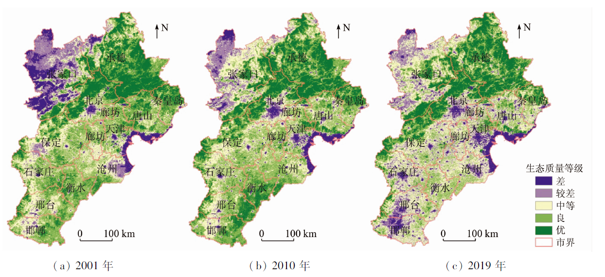
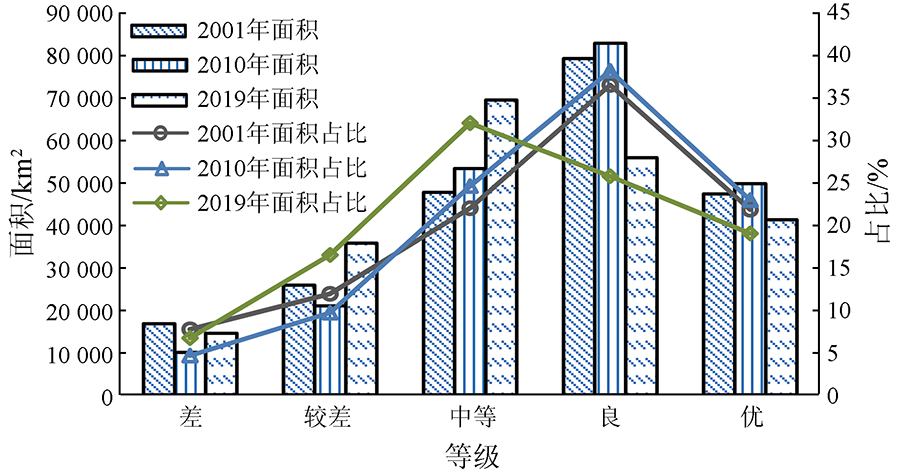
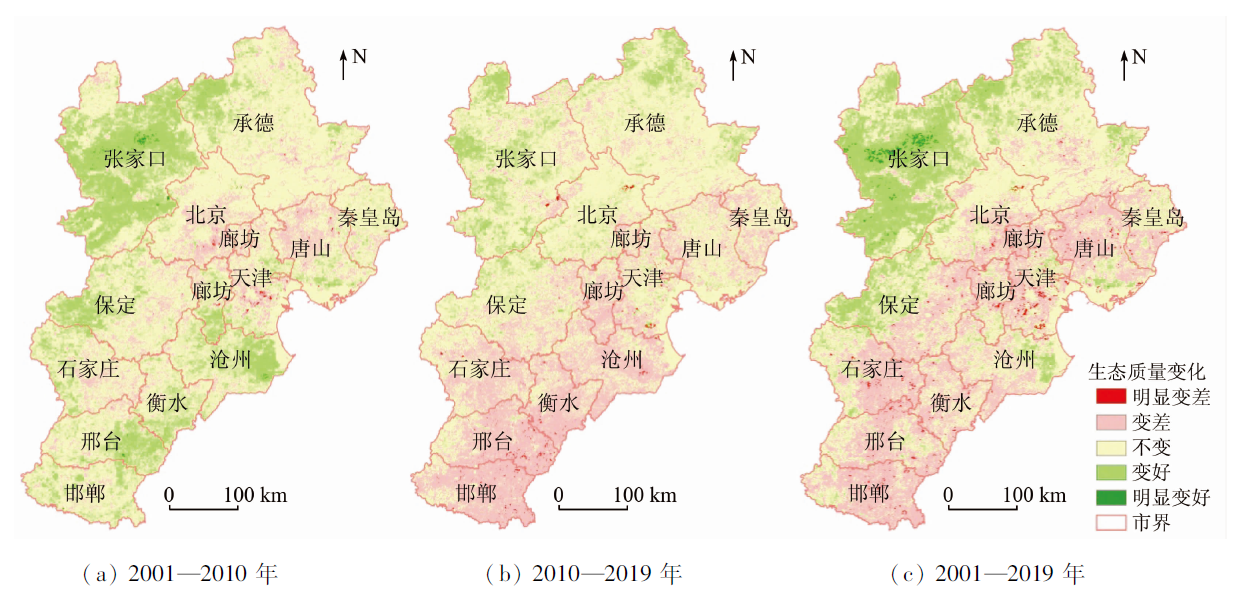
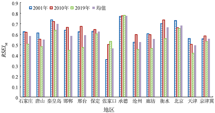
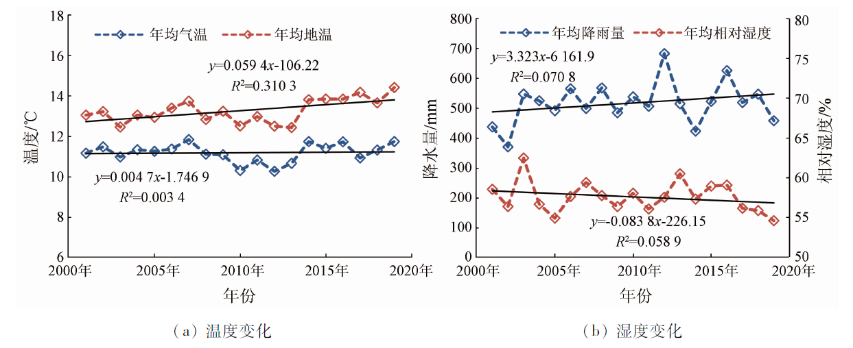
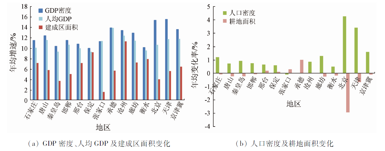
Ecological quality assessment is an important prerequisite for guaranteeing the harmony and stability of the production and life of human beings and the ecological environment and for achieving the sustainable development of regional social economy. It has become a new trend to quickly, accurately, and objectively assess the regional ecological quality using use remote sensing technology. This study used the MODIS data of the Beijing-Tianjin-Hebei region in 2001, 2010, and 2019 to extract four important indices, namely, NDVI (greenness), LSM (humidity), NDBSI (dryness), and LST (heat). Then, this study obtained the MODIS remote sensing ecological index (RSEIM) using the principal component analysis method to conduct a comprehensive assessment and change monitoring of the ecological quality in the Beijing-Tianjin-Hebei region over the past 20 years. The results are as follows. ① The ecological quality of the Beijing-Tianjin-Hebei region shows distinct regional differences. The Yanshan Mountain in the north and the Taihang Mountain in the west have high ecological quality, while the Zhangjiakou area in the northwestern part of Hebei Province and the urban center in the southeastern part of Hebei Province suffer low ecological quality. ② In 2001, 2010, and 2019, the average RSEIM of the Beijing-Tianjin-Hebei region was 0.556, 0.583, and 0.527, respectively, with the overall ecological quality showing a downward trend. ③ From 2001 to 2019, the area with improved and degraded ecological quality in the Beijing-Tianjin-Hebei region accounted for 20.18% and 35.69% respectively, and the ecological quality in this region showed a pattern of improvement in the northwest and degradation in the southeast. The main reasons for the ecological improvement in the northwestern part of the region are the changes in water and heat conditions, such as an increase in precipitation and temperature, and a series of man-made protection measures. The reasons for ecological degradation in the southeastern part of the Beijing-Tianjin-Hebei region mainly include the rapid advancement of urbanization and the enhancement of social and economic activities. The comprehensive assessment of regional ecological quality can be effectively achieved based on MODIS data, thus providing a reference for the green and high-quality development of regional social economy.
Wu J. Urban ecology and sustainability:The state-of-the-science and future directions[J]. Landscape and Urban Planning, 2014, 125:209-221.
doi: 10.1016/j.landurbplan.2014.01.018
Fan J, Wang Y F. Pattern evolution of China’s economic geography in the past 40 years and regional coordinated development in the new era[J]. Economic Geography, 2019, 39(1):1-7.
doi: 10.2307/142491
Liang L W, Wang Z B, Fang C L, et al. Spatiotemporal differentiation and coordinated development pattern of urbanization and the ecological environment of the Beijing-Tianjin-Hebei urban agglomeration[J]. Acta Ecological Sinica, 2019, 39(4):1212-1225.
Rao L, Zhou L J, Xu C, et al. Connotation,method and practice of the quality assessment on eco-environment[J]. Subtropical Soil and Water Conservation, 2020, 32(3):37-41,54.
Ma J, Li C X, Wei H, et al. Dynamic evaluation of ecological vulnerability in the Three Gorges Reservoir Region in Chongqing Municipality,China[J]. Acta Ecological Sinica, 2015, 35(21):7117-7129.
Wang Y, Xie R R, Wang F F, et al. Evaluation on eco-security of Qilian Mountain National Nature Reserve based on Delphi-PSR model[J]. Mountain Research, 2019, 37(3):328-336.
[8]
Liu G, Wang J, Li S, et al. Dynamic evaluation of ecological vulnerability in a lake watershed based on RS and GIS technology[J]. Polish Journal of Environmental Studies, 2019, 28(3):1785-1798.
doi: 10.15244/pjoes/89981
[9]
He F, Gu L, Wang T, et al. The synthetic geo-ecological environmental evaluation of a coastal coal-mining city using spatiotemporal big data:A case study in Longkou,China[J]. Journal of Cleaner Production, 2017, 142:854-866.
doi: 10.1016/j.jclepro.2016.07.011
Zhou W Y, He B B. Eco-environmental quality assessment of Ruoergai County in Sichuan Province based on multi-sources remote sensing data[J]. Journal of Geo-information Science, 2014, 16(2):314-319.
[11]
Wang X, Cao Y, Zhong X, et al. A new method of regional eco-environmental quality assessment and its application[J]. Journal of Environmental Quality, 2012, 41(5):1393-1401.
doi: 10.2134/jeq2011.0390
[12]
Liu Y, Yue W, Fan P, et al. Assessing the urban environmental quality of mountainous cities:A case study in Chongqing,China[J]. Ecological Indicators, 2017, 81:132-145.
doi: 10.1016/j.ecolind.2017.05.048
Pan Y, Gong H D, Dong L Q, et al. Comprehensive assessment of ecological environment quality in Jinxiu area based on analytic hierarchy process[J]. Journal of Southwest Foresty University(Natural Science Edition), 2017, 37(3):74-80.
Zhao H Q, Jia L, Yin Z R, et al. Dynamic monitoring of land use and ecological environment based on multiple remote sensing data:A case study of Tongzhou District,Beijing[J]. Geography and Geo-information Science, 2019, 35(1):38-43.
[15]
Wang S, Liu J, Yang C. Eco-environmental vulnerability evaluation in the Yellow River Basin,China[J]. Pedosphere, 2008, 18(2):171-182.
doi: 10.1016/S1002-0160(08)60005-3
Xu H Q. A remote sensing index for assessment of regional ecological changes[J]. China Environmental Science, 2013, 33(5):889-897.
[18]
Yue H, Liu Y, Li Y, et al. Eco-environmental quality assessment in China’s 35 major cities based on remote sensing ecological index[J]. IEEE Access, 2019, 7:51295-51311.
doi: 10.1109/ACCESS.2019.2911627
Rukeya S, Abuduheni A, Li H, et al. Dynamic monitonring and analysis of ecological environment in Fukang City based on RSEI model[J]. Research of Soil and Water Conservation, 2020, 27(1):283-297.
Fang C Y, Hu X J, Xu H Q, et al. Comparison of the ecological quality between different urban plannings[J]. Journal of Geo-Information Science, 2017, 19(8):1097-1107.
Wu Y J, Zhao X S, Xi Y, et al. Comprehensive evaluation and spatial-temporal changes of eco-environmental quality based on MODIS in Tibet during 2006—2016[J]. Acta Geographica Sinica, 2019, 74(7):1438-1449.
[22]
Xu H, Wang Y, Guan H, et al. Detecting ecological changes with a remote sensing based ecological index (RSEI) produced time series and change vector analysis[J]. Remote Sensing, 2019, 11(20):2345.
doi: 10.3390/rs11202345
Li X Y, Kuang W H. Spatio-temporal trajectories of urban land use change during 1980—2015 and future scenario simulation in Beijing-Tianjin-Hebei urban agglomeration[J]. Economic Geography, 2019, 39(3):187-194.
[24]
Carlson T N, Ripley D A. On the relation between NDVI,fractional vegetation cover,and leaf area index[J]. Remote Sensing of Environment, 1997, 62(3):241-252.
doi: 10.1016/S0034-4257(97)00104-1
[25]
Feng L, Jia Z, Li Q, et al, Zhang Z. Spatiotemporal change of sparse vegetation coverage in Northern China[J]. Journal of the Indian Society of Remote Sensing, 2019, 47(2):359-366.
doi: 10.1007/s12524-018-0912-x
Guo T, Yu H B, Ma Z C, et al. Analysis of spatial and temporal variations of soil moisture content and drought degree based on MODIS[J]. Research of Soil and Water conservation, 2019, 26(4):185-189.
Xu H Q. A new index-based built-up index (IBI) and its eco-environmental significance[J]. Remote Sensing Technology and Application, 2007, 22(3):301-308.
Li X, Xu H Q, Li J, et al. Extraction of bare soil features from SPOT-5 imagery based on NDSI and NDISI[J]. Journal of Geo-Information Science, 2016, 18(1):117-123.
Yang J Y, Wu T, Pan X Y, et al. Ecological quality assessment of Xiong’an New Area based on remote sensing ecological index[J]. Chinese Journal of Applied Ecology, 2019, 30(1):277-284.
Wang J, Zhou W Q, Xu K P, et al. Quantitative assessment of ecological quality in Beijing-Tianjin-Hebei urban megaregion,China[J]. Chinese Journal of Applied Ecology, 2017, 28(8):2667-2676.
Wang W, Wang X L, Feng Z K, et al. Dynamic evaluation of eco-environmental quality in the capital economic circle based on RS and GIS[J]. Journal of Anhui Agricultural University, 2015, 42(2):257-262.
Wang W W, Xu Q Y, Mo L. Eco-environment impact assessment of built-up area of Beijing-Tianjin-Hebei urban agglomeration[J]. Environment Ecology, 2020, 2(5):27-34.
Xu Y, Huang W T, Jing J L, et al. Dynamic variation of vegetation cover and its relation with climate variables in Beijing-Tianjin-Hebei region[J]. Bulletin of Soil and Water conservation, 2020, 40(5):319-327.
Chen J, Han S Q, Xiao W W. Study on spatio-temporal changes and rehabilitation of saline-alkali land in the coastal area of Cangzhou[J]. Natural Resource Economics of China, 2018,(11):38-43.
Xu Y Q, Zhao F F, Sun P L. Evaluation of land ecological security inecological fragile area:A case study of Zhangjiakou City,Hebei Province[J]. Bulletin of Soil and Water Conservation, 2015, 35(5):232-238.
Huang L, Wu D, Sun C Y. The ecological effects of ecosystem conservation and restoration in Beijing-Tianjin sand source regions based on the planning objects[J]. Acta Ecological Sinica, 2020, 40(6):1923-1932.
Zhou S, Huang Y F, Wang G Q. Changes in the ecological environment and there determining factors in the middle Heihe River Basin[J]. China Environmental Science, 2014, 34(3):766-773.
He C L, Pu J W, Shen J X. Spatial-temporal changes and driving mechanisms of landscape ecological security in lower reaches of Lancang River during 2005—2018[J]. Bulletin of Soil and Water Conservation, 2020, 40(4):219-227.
[40]
Lobser S E, Cohen W B. MODIS tasselled cap:Land cover characteristics expressed through transformed MODIS data[J]. International Journal of Remote Sensing, 2007, 28(22):5079-5101.
doi: 10.1080/01431160701253303
 2022, Vol. 34
  ), 孙雷刚1,2,3(