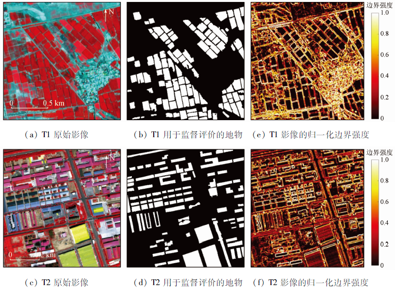
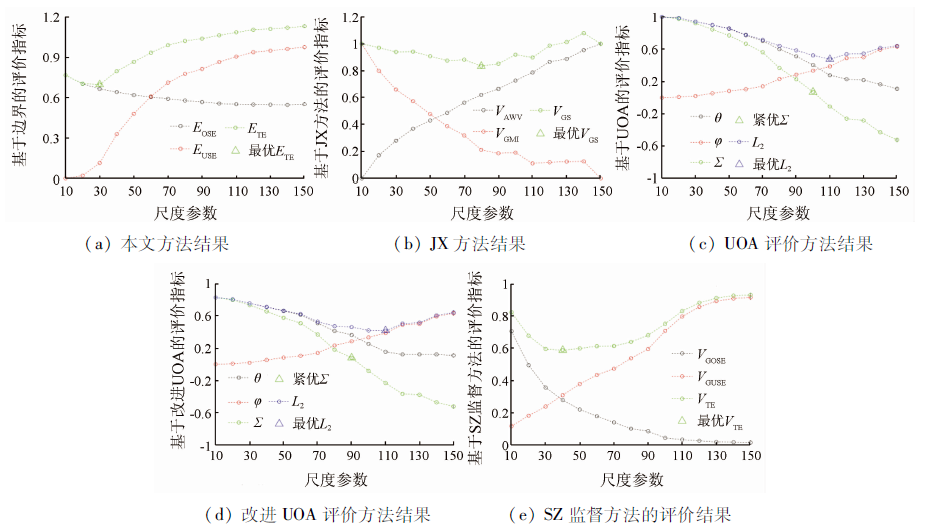
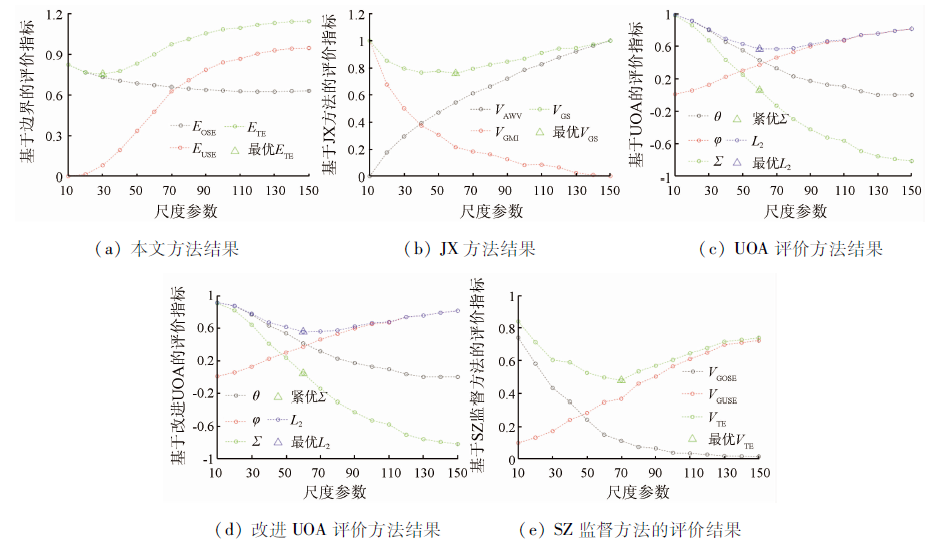
Multi-scale segmentation is a key step in the information extraction of high-resolution remote sensing images. However, the evaluation of segmentation quality and the quantification of segmentation errors are still challenging. Based on boundary strength information, this study developed an unsupervised segmentation evaluation method of selecting the optimal scale parameter and elevating the local segmentation quality for multi-scale remote sensing image segmentation. Segmentation errors include over-segmentation and under-segmentation. This study modeled the two types of errors using normalized boundary gradient characteristics. The gradient information of patch edges was considered in the estimation of over-segmentation errors, while the intra-patch gradients were employed for the assessment of under-segmentation errors. To validate the proposed method, this study conducted an experiment on the evaluation of multi-scale segmentation results using two scenes of high-resolution remote sensing images. The segmentation evaluation results of the method coincided perfectly with the actual segmentation effects. The results indicate that the method proposed in this study can effectively reflect over- and under-segmentation errors.
Hossain M, Chen D. Segmentation for object-based image analysis(OBIA):A review of algorithms and challenges from remote sensing perspective[J]. ISPRS Journal of Photogrammetry and Remote Sensing, 2019, 150(1):115-134.
doi: 10.1016/j.isprsjprs.2019.02.009
[2]
Beauchemin M. Semi-supervised map regionalization for categorical data[J]. International Journal of Remote Sensing, 2019, 40(24):9401-9411.
doi: 10.1080/2150704X.2019.1633485
[3]
Xiang D, Wang W, Tang T, et al. Adaptive statistical superpixel merging with edge penalty for polsar image segmentation[J]. IEEE Transactions on Geo-scienceand Remote Sensing, 2019, 58(4):2412-2429.
[4]
Zhang M, Xue Y, Ge Y, et al. Watershed segmentation algorithm based on luv color space region merging for extracting slope hazard boundaries[J]. ISPRS International Journal of Geo-Information, 2020, 9(4):246.
doi: 10.3390/ijgi9040246
[5]
Su T F, Liu T X, Zhang S W, et al. Machine learning-assisted region merging for remote sensing image segmentation[J]. ISPRS Journal of Photogrammetry and Remote Sensing, 2019, 168(1):89-123.
doi: 10.1016/j.isprsjprs.2020.07.017
Zhang D M, Zhang X Y, Li L, et al. Remote sensing image segmentation based on Parzen window density estimation of super-pixels[J]. Remote Sensing for Land and Resources, 2022, 34(1):53-60.doi:10.6046/gtzyyg.2021089.
doi: 10.6046/gtzyyg.2021089
[7]
Baatz M, Schäpe A. Multiresolution segmentation:An optimizing approach for high quality multi-scale segmentation[C]. Angewandte Geographich Informationsverarbeitung, 2000,XII,12-23.
Fan Y L, Lou D B, Zhang C Q, et al. Information extraction technologies of iron mine tailings based on object-oriented classification:A case study of Beijing-2 remote sensing images of the Qianxi Area,Hebei Province[J]. Remote Sensing for Natural Resources, 2021, 33(4):153-161.doi:10.6046/zrzyyg.2021027.
doi: 10.6046/zrzyyg.2021027
Wang H, Li W W, Li Z G, et al. Hyperspectral image classification based on multiscale superpixels[J]. Remote Sensing for Natural Resources, 2021, 33(3):63-71.doi:10.6046/zrzyyg.2020344.
doi: 10.6046/zrzyyg.2020344
[10]
Costa H, Foody G M, Boyd D S. Supervised methods of image segmentation accuracy assessment in land cover mapping[J]. Remote Sensing of Environment, 2018, 205(2):338-351.
doi: 10.1016/j.rse.2017.11.024
[11]
Witharana C, Civco D L. Optimizing multi-resolution segmentation scale using empirical methods:Exploring the sensitivity of the supervised discrepancy measure euclidean distance 2(ED2)[J]. ISPRS Journal of Photogrammetry and Remote Sensing, 2014, 87(1):108-121.
doi: 10.1016/j.isprsjprs.2013.11.006
[12]
Su T F, Zhang S W. Multi-scale segmentation method based on binary merge tree and class label information[J]. IEEE Access, 2018, 6(1):17801-17816.
doi: 10.1109/ACCESS.2018.2819988
[13]
Su T F, Zhang S W. Local and global evaluation for remote sensing image segmentation[J]. ISPRS Journal of Photogrammetry and Remote Sensing, 2017, 130(1):256-276.
doi: 10.1016/j.isprsjprs.2017.06.003
[14]
Johnson B, Xie Z. Unsupervised image segmentation evaluation and refinement using a multi-scale approach[J]. ISPRS Journal of Photogrammetry and Remote Sensing, 2011, 66(1):473-483.
doi: 10.1016/j.isprsjprs.2011.02.006
[15]
Yang J, He Y, Weng Q. An automated method to parameterize segmentation scale by enhancing intrasegment homogeneity and intersegment heterogeneity[J]. IEEE Geoscience and Remote Sensing Letters, 2015, 12(6):1282-1286.
doi: 10.1109/LGRS.2015.2393255
[16]
Troya-Galvis A, Gançarski P, Passat N, et al. Unsupervised quantification of under- and over-segmentation for object-based remote sensing image analysis[J]. IEEE Transactions on Geoscience and Remote Sensing, 2015, 8(5):1936-1945.
[17]
Su T F. Unsupervised evaluation-based region merging for high resolution remote sensing image segmentation[J]. GIScience & Remote Sensing, 2019, 56(6):811-842.
 2023, Vol. 35
  )
)