1. Key Laboratory of Digital Earth Science, Institute of Remote Sensing and Digital Earth, Chinese Academy of Sciences, Beijing 100094, China 2. International Research Center of Big Data for Sustainable Development Goals, Beijing 100094, China 3. University of Chinese Academy of Sciences, Beijing 100049, China 4. Institute of Geodesy and Geoinformation, University of Bonn, Bonn 53115, Germany
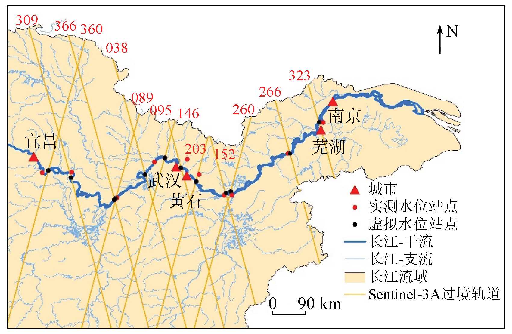
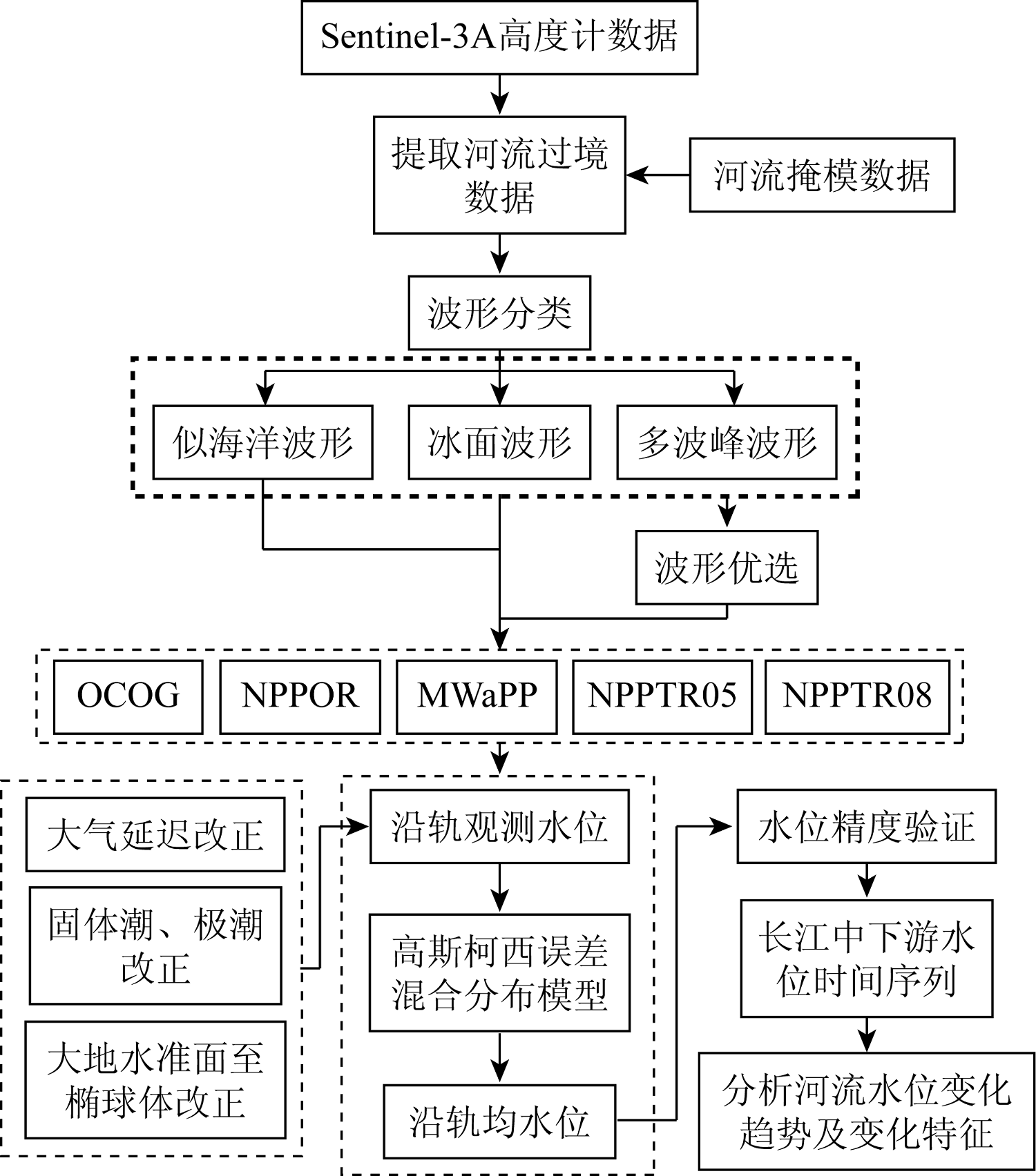
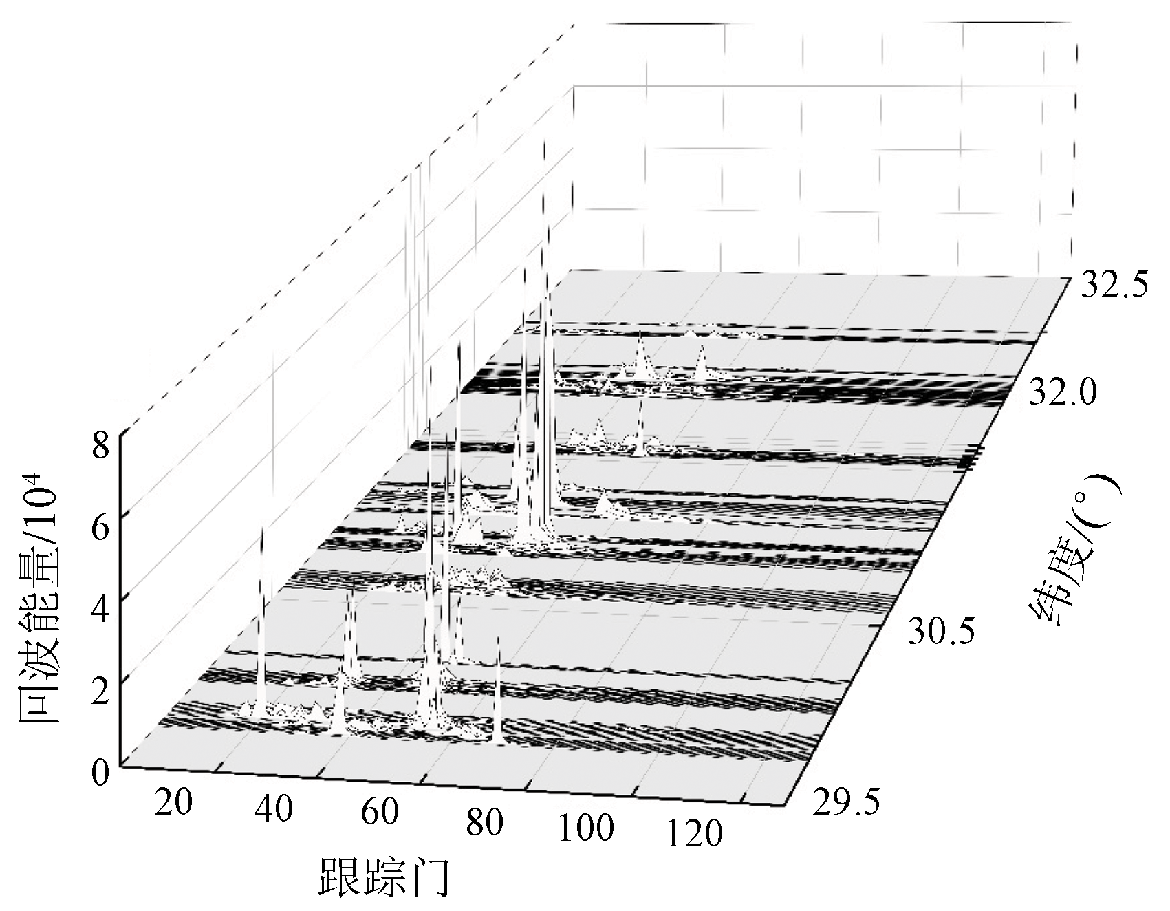
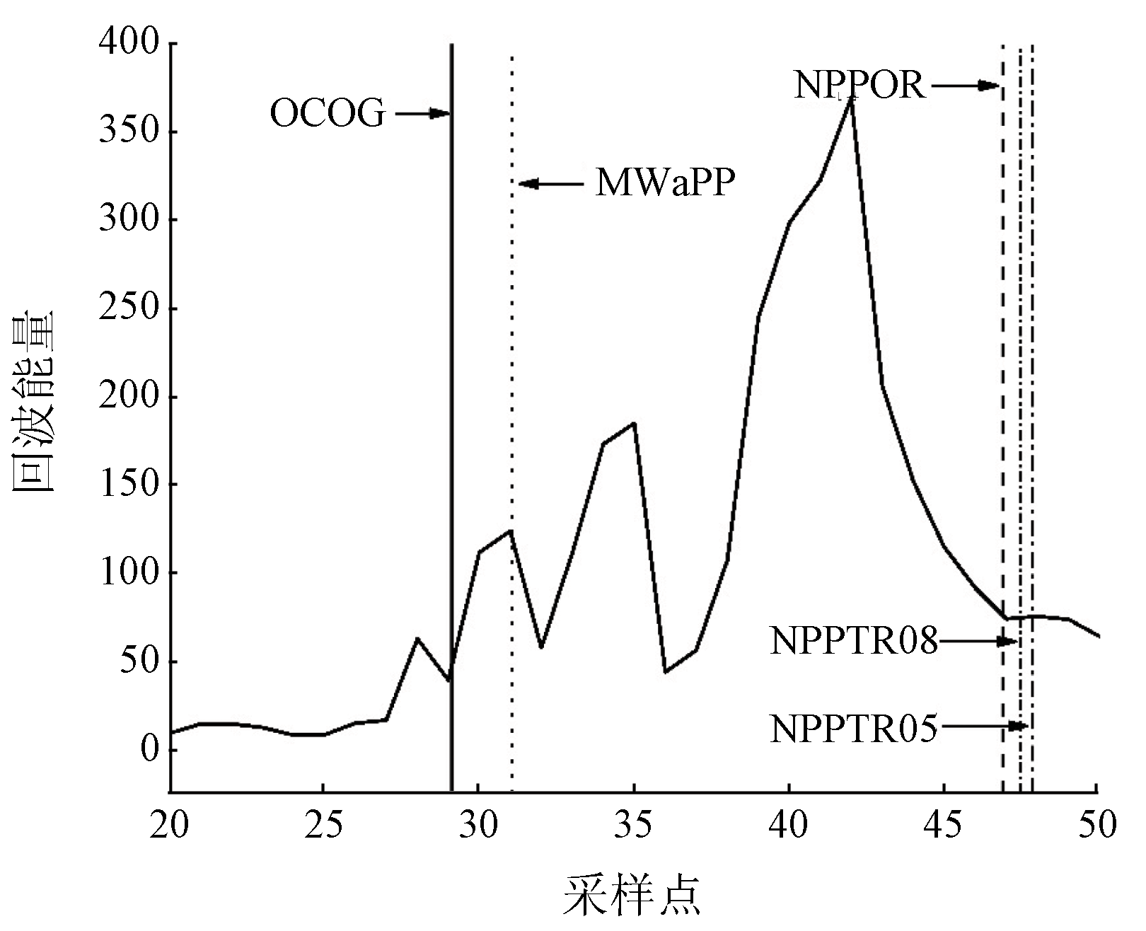
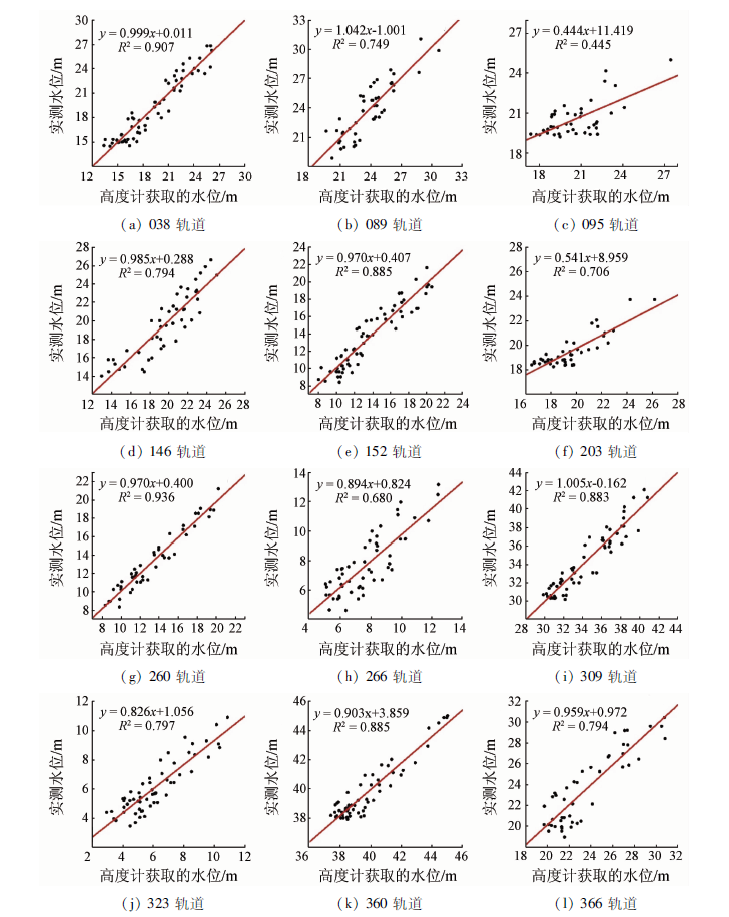
River levels serve as a critical parameter for understanding the changes in water cycles and water resources. An advanced Radar altimeter is a favorable tool for extracting the changes in river levels. This study aims to verify the ability of the Sentinel-3A/SRAL Radar altimeter to monitor river levels and improve the extraction accuracy of this Radar altimeter. With the main streams in the middle and lower reaches of the Yangtze River as the study area, this study conducted waveform retracking for the Sentinel-3A/SRAL L2 data using the center-of-gravity offset method, the primary peak threshold retracking algorithm (thresholds: 50% and 80%), the primary waveform centroid retracking algorithm, and the multiple-echo peak consistency retracking algorithm. Then, this study extracted the river levels during 2016—2021 in the study area and obtained the optimal retracking algorithm by comparing the accuracy of different algorithms. Based on the optimal retracking algorithm, this study extracted the water level changes in transit areas of 12 satellite orbits to analyze the water level change patterns. The results show that the center-of-gravity offset method is the optimal retracking algorithm for extracting river levels with the highest accuracy. Compared with the measured water levels, the water levels simulated using the center-of-gravity offset method exhibited the highest correlation coefficient (up to 0.968) and the smallest root mean square error (up to 0.680 m). During 2016—2021, the water levels in the study area generally showed an upward trend, with significant intra-annual seasonal changes.
娄燕寒, 廖静娟, 陈嘉明. Sentinel-3A卫星测高数据监测长江中下游河流水位变化[J]. 自然资源遥感, 2023, 35(3): 221-229.
LOU Yanhan, LIAO Jingjuan, CHEN Jiaming. Monitoring water level changes in the middle and lower reaches of the Yangtze River using Sentinel-3A satellite altimetry data. Remote Sensing for Natural Resources, 2023, 35(3): 221-229.
Gao Q, Makhoul E, Escorihuela M J, et al. Analysis of retrackers’ performances and water level retrieval over the Ebro River basin using Sentinel-3[J]. Remote Sensing, 2019, 11(6):718.
doi: 10.3390/rs11060718
[2]
Huang Q, Li X D, Han P F, et al. Validation and application of water levels derived from Sentinel-3A for the Brahmaputra River[J]. Science China-Technological Sciences, 2019, 62(10):1760-1772.
doi: 10.1007/s11431-019-9535-3
[3]
Detlef S, Anny C. Satellite altimetry over oceans and land surfaces[M]. Boca Raton: CRC Press, 2017.
[4]
Kittel C M M, Jiang L, Tttrup C, et al. Sentinel-3 Radar altimetry for river monitoring:A catchment-scale evaluation of satellite water surface elevation from Sentinel-3A and Sentinel-3B[J]. Hydrology and Earth System Sciences, 2021, 25(1):333-357.
doi: 10.5194/hess-25-333-2021
Zhao Y, Liao J J, Shen G Z, et al. Monitoring the water level changes in Qinghai Lake with satellitealtimetry data[J]. Journal of Remote Sensing, 2017, 21(4):633-644.
[6]
Hwang C, Guo J Y, Deng X L, et al. Coastal gravity anomalies from retracked geosat/GM altimetry:Improvement,limitation and the role of airborne gravity data[J]. Journal of Geodesy, 2006, 80(4):204-216.
doi: 10.1007/s00190-006-0052-x
[7]
Bao L F, Lu Y, Wang Y. Improved retracking algorithm for oceanic altimeter waveforms[J]. Progress in Natural Science, 2009, 19(2):195-203.
doi: 10.1016/j.pnsc.2008.06.017
[8]
Yang L, Lin M S, Liu Q H, et al. A coastal altimetry retracking strategy based on waveform classification and sub-waveform extraction[J]. International Journal of Remote Sensing, 2012, 33(24):7806-7819.
doi: 10.1080/01431161.2012.701350
[9]
Kleinherenbrink M, Ditmar P G, Lindenbergh R C. Retracking Cryo-sat data in the SARIn mode and robust lake level extraction[J]. Remote Sensing of Environment, 2014, 152:38-50.
doi: 10.1016/j.rse.2014.05.014
[10]
Kleinherenbrink M, Lindenbergh R C, Ditmar P G. Monitoring of lake level changes on the Tibetan Plateau and Tian Shan by retracking CryoSat SARIn waveforms[J]. Journal of Hydrology, 2015, 521:119-131.
doi: 10.1016/j.jhydrol.2014.11.063
[11]
Jain M, Andersen O B, Dall J, et al. Sea surface height determination in the Arctic using CryoSat-2 SAR data from primary peak empirical retrackers[J]. Advances in Space Research, 2015, 55(1):40-50.
doi: 10.1016/j.asr.2014.09.006
[12]
Wingham D J, Rapley C G, Griffiths H. New techniques in satellite altimeter tracking systems[C]// Proceedings of IGARSS.IEEE, 1986, 86:1339-1344.
[13]
Davis C H. Growth of the Greenland ice sheet:A performance assessment of altimeter retracking algorithms[J]. IEEE Transactions on Geoscience and Remote Sensing, 1995, 33(5):1108-1116.
doi: 10.1109/36.469474
[14]
Martin T V, Zwally H J, Brenner A C, et al. Analysis and retracking of continental ice sheet Radar altimeter waveforms[J]. Journal of Geophysical Research Oceans, 1983, 88(c3):1608-1616.
[15]
Biswas N K, Hossain F, Bonnema M, et al. An altimeter height extraction technique for dynamically changing rivers of South and South-East Asia[J]. Remote Sensing of Environment, 2019, 221:24-37.
doi: 10.1016/j.rse.2018.10.033
Liu Q, Li Q, Wei J H, et al. Research progress of water level extraction methods based on satellite altimeter[J]. South-to-North Transfer and Water Science and Technology, 2021, 19(2) :281-292.
[17]
Lee H, Shum C K, Yi Y, et al. Laurentia crustal motion observed using TOPEX/POSEIDON Radar altimetry over land[J]. Journal of Geodynamics, 2008, 46(3-5):182-193.
doi: 10.1016/j.jog.2008.05.001
[18]
Villadsen H, Deng X, Andersen O B, et al. Improved inland water levels from SAR altimetry using novel empirical and physical retrackers[J]. Journal of Hydrology, 2016, 537:234-247.
doi: 10.1016/j.jhydrol.2016.03.051
[19]
Huang Q, Long D, Du M, et al. An improved approach to monitoring Brahmaputra River water levels using retracked altimetry data[J]. Remote Sensing of Environment, 2018, 211:112-28.
doi: 10.1016/j.rse.2018.04.018
Xu Q X, Dong B J, Zhang W. Characteristics and analysis of erosion and deposition changes in the middle and lower reaches of the Yangtze River in 2020[J]. People’s Yangtze River, 2021, 52(12):1-8.
Liao J J, Xue H, Chen J M. Monitoring lake level changes on the Tibetan Plateau from 2000 to 2018 using satellite altimetry data[J]. Journal of Remote Sensing, 2020, 24(12):1534-1547.
[22]
Ayana E K. Validation of Radar altimetry lake level data and it’s application in water resource management[D]. The Netherlands: International Institute for Geo-Information Science and Earth Observation (ITC), 2007.
[23]
Arabsahebi R, Voosoghi B, Tourian M J. The inflection-point retracking algorithm:Improved Jason-2 sea surface heights in the Strait of Hormuz[J]. Marine Geodesy, 2018, 41(4):331-352.
doi: 10.1080/01490419.2018.1448029
Chu Y H, Li J C, Zhang Y, et al. Research on waveform re-tracking analysis of ENVISAT altimetry data[J]. Geodesy and Geodynamics, 2005, 25(1):76-80.
[25]
Jiang L, Nielsen K, Andersen O B, et al. CryoSat-2 Radar altimetry for monitoring freshwater resources of China[J]. Remote Sensing of Environment, 2017, 200:125-139.
doi: 10.1016/j.rse.2017.08.015
[26]
Xue H, Liao J, Zhao L. A modified empirical retracker for lake level estimation using CryoSat-2 SAR in data[J]. Water, 2018, 10(11):1584.
doi: 10.3390/w10111584
Mo D L, Zhao Y J, Chen G Q, et al. Research on adaptive waveform re-tracking algorithm based on main wave crest[J]. Geodesy and Geodynamics, 2021, 41(10):1051-1056.
 2023, Vol. 35
  ), 廖静娟1,2(