Please wait a minute...
 
自然资源遥感  2023, Vol. 35 Issue (3): 212-220    DOI: 10.6046/zrzyyg.2022240
  技术应用 本期目录 | 过刊浏览 | 高级检索 |
2001—2021年川西高原植被NDVI时空变化及影响因素分析
王叶兰1(), 杨鑫1,2(), 郝利娜1
1.成都理工大学地球科学学院,成都 610059
2.地球勘探与信息技术教育部重点实验室,成都 610059
Spatio-temporal changes in the normalized difference vegetation index of vegetation in the western Sichuan Plateau during 2001—2021 and their driving factors
WANG Yelan1(), YANG Xin1,2(), HAO Lina1
1. College of Earth Sciences, Chengdu University of Technology, Chengdu 610059, China
2. Key Laboratory of Earth Exploration and Information Technology, Ministry of Education, Chengdu 610059, China
全文: PDF(4210 KB)   HTML  
输出: BibTeX | EndNote (RIS)      
摘要 

川西高原是青藏高原与四川盆地间重要的生态屏障,生态坏境脆弱敏感,研究其植被归一化植被指数(normalized difference vegetation index,NDVI)动态变化及其驱动因子,对监测生态环境质量具有重要现实意义。以2001—2021年MODIS NDVI 数据为基础,结合气象数据、地表因子数据以及人类活动数据,利用趋势分析、Hurst指数以及地理探测器分析时空尺度下川西高原植被NDVI的分布特征,探索影响NDVI变化的主要驱动因子。结果表明,2001—2021年川西高原67.19%的区域植被NDVI表现为波动上升趋势; 高程是影响植被NDVI的最主要因子,其解释力为0.529,其次为≥0 ℃积温与气温; 影响因子间交互作用为非线性增强与双因子增强,其中相对湿度∩高程的q值最高,为0.623; 84%的因子组合对川西高原植被 NDVI 空间分布的影响存在显著差异。研究结果有助于研究植被生长的驱动机制,可为川西高原植被保护提供参考。

服务
把本文推荐给朋友
加入引用管理器
E-mail Alert
RSS
作者相关文章
王叶兰
杨鑫
郝利娜
关键词 川西高原NDVI地理探测器时空变化驱动因子    
Abstract

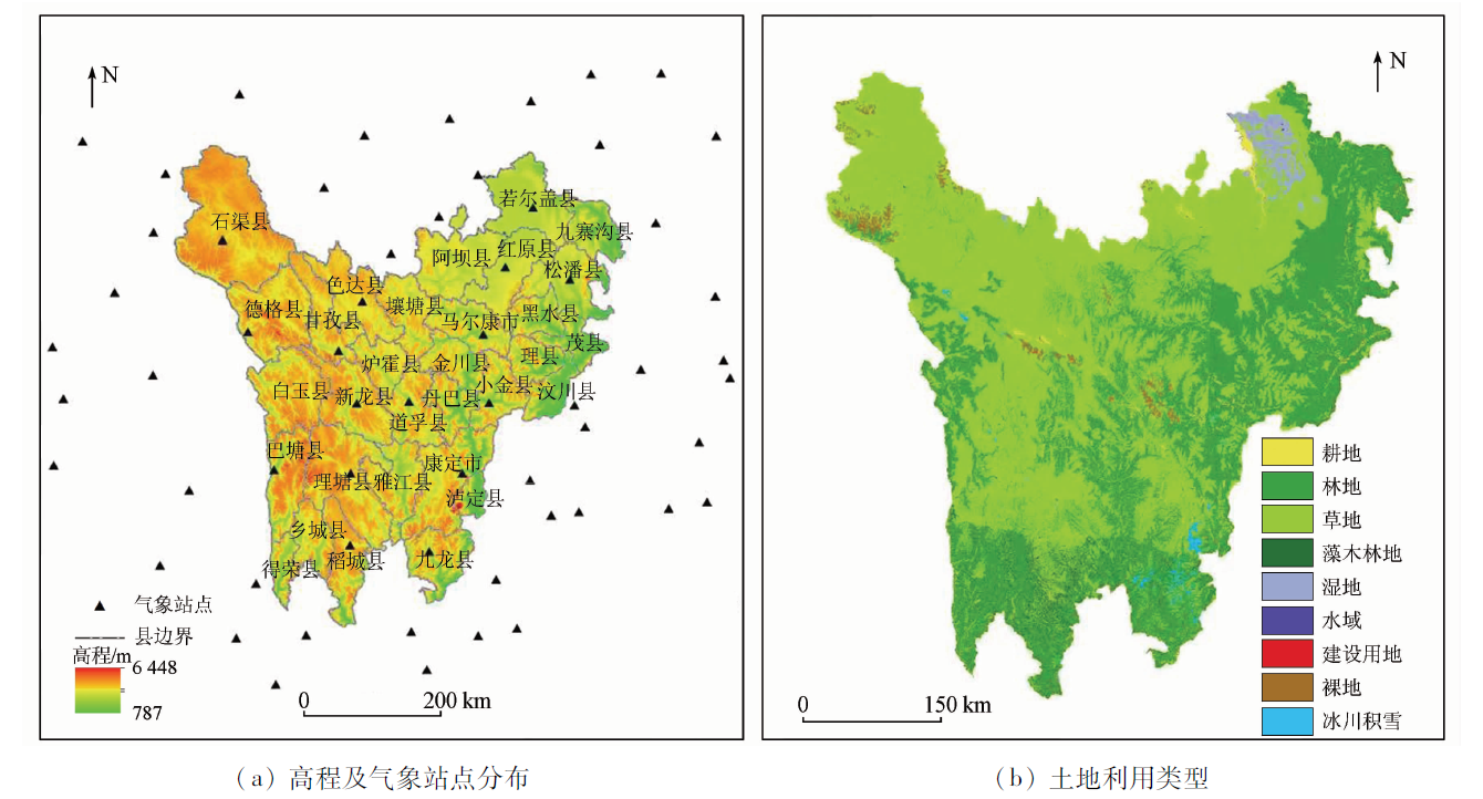
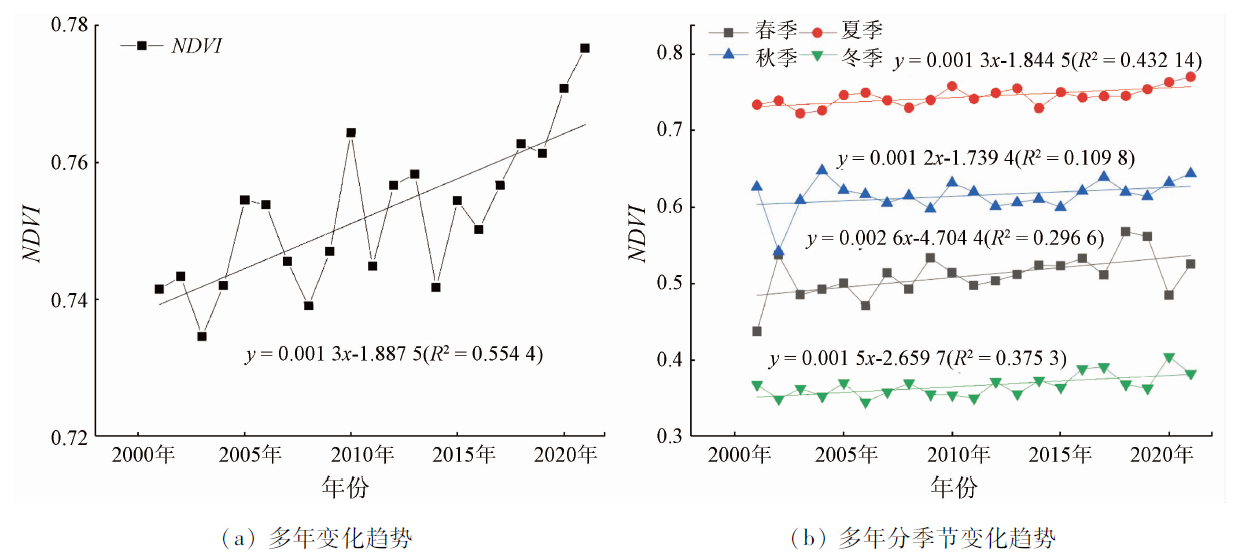
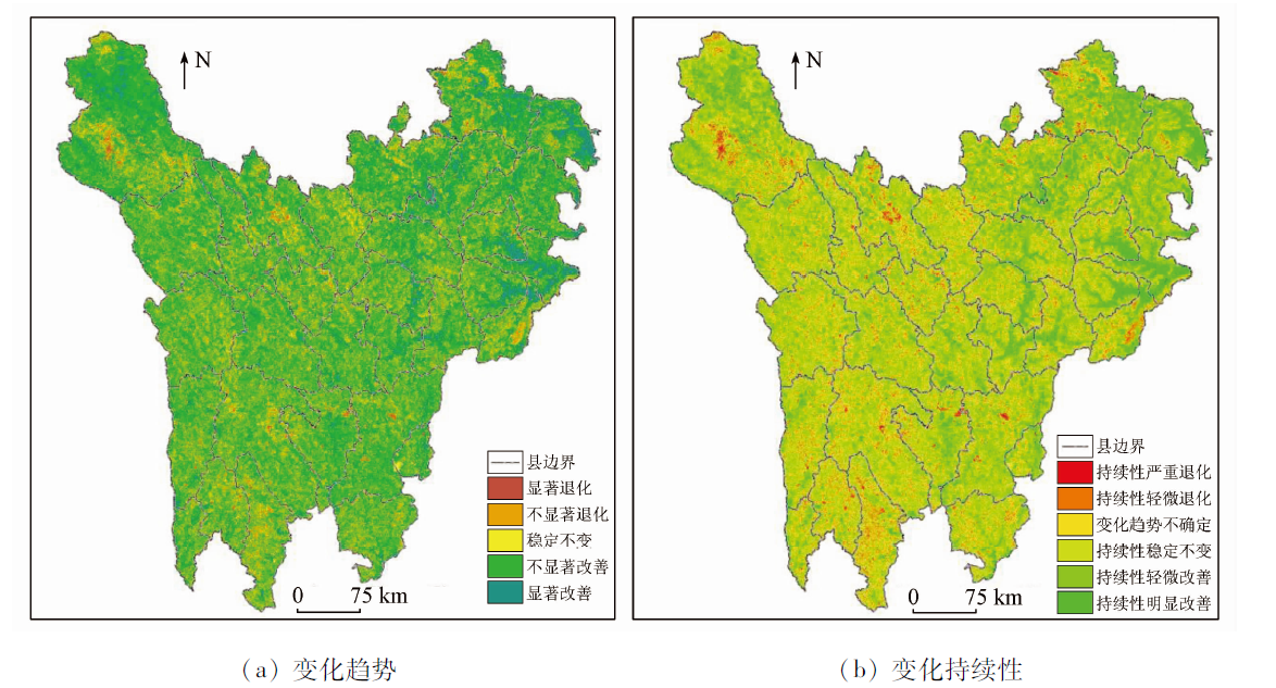
The western Sichuan Plateau, with a fragile and sensitive ecological environment, acts as a critical ecological barrier between the Qinghai-Tibet Plateau and the Sichuan Basin. Research on the dynamic changes in the normalized difference vegetation index (NDVI) and their driving factors holds practical significance for monitoring the ecological environment quality of the western Sichuan Plateau. Based on 2001—2021 MODIS NDVI data, as well as meteorological data, surface factor data, and human activity data, this study analyzed the NDVI distribution of vegetation in the western Sichuan Plateau on a spatio-temporal scale using trend analysis, Hurst index, and geographical detector. Furthermore, this study determined the principal driving factors in NDVI changes. The results are as follows: During 2001—2021, the NDVI of 67.19% of regional vegetation in the western Sichuan Plateau showed a fluctuating upward trend. Elevation is the most critical factor influencing NDVIs, with an explanatory power of 0.529. The elevation is followed by accumulated temperature ≥0 ℃ and air temperature. The driving factors in interactions among NDVI exhibited nonlinear or double-factor enhancement, with q values between relative humidity and elevation being highest (0.623). 84% of factor combinations showed significantly different effects on the spatial NDVI distribution in the western Sichuan Plateau. The results of this study facilitate the research on the driving mechanism of vegetation growth, providing a reference for vegetation protection in the western Sichuan Plateau.

Key wordswestern Sichuan Plateau    NDVI    geographical detector    spatio-temporal change    driving factor
收稿日期: 2022-06-10      出版日期: 2023-09-19
ZTFLH:  TP79  
  Q948  
基金资助:中国博士后科学基金第13批特别项目“重大工程背景下黄土高原生态地质环境脆弱性评价”(2020T130074);中国博士后科学基金项目(二等)“近50年黑方台黄土滑坡与农作物更替时空耦合机制分析”(2017M622982)
通讯作者: 杨 鑫(1984-),男,博士,副教授,研究方向为“3S”技术在地学中的应用。Email: yangxin2012@cdut.edu.cn
作者简介: 王叶兰(1998-),女,硕士研究生,研究方向为植被生态遥感。Email: 1747473516@qq.com
引用本文:   
王叶兰, 杨鑫, 郝利娜. 2001—2021年川西高原植被NDVI时空变化及影响因素分析[J]. 自然资源遥感, 2023, 35(3): 212-220.
WANG Yelan, YANG Xin, HAO Lina. Spatio-temporal changes in the normalized difference vegetation index of vegetation in the western Sichuan Plateau during 2001—2021 and their driving factors. Remote Sensing for Natural Resources, 2023, 35(3): 212-220.
链接本文:  
https://www.gtzyyg.com/CN/10.6046/zrzyyg.2022240      或      https://www.gtzyyg.com/CN/Y2023/V35/I3/212
Fig.1  研究区位置
类型 影响因子
气象因子 气温(X1) 降水量(X2) 相对湿度(X3)
日照(X4) ≥0 ℃积温
(X5)
≥10 ℃积温
(X6)
地表因子 高程(X7) 坡度(X8) 坡向(X9)
地貌类型
(X10)
植被类型
(X11)
土壤类型
(X12)
人类活动因子 人口密度
(X13)
GDP(X14)
Tab.1  影响因子指标
数据类型 数据来源 产品 分辨率 预处理
NDVI 美国国家航空航天局 MOD13Q1 16 d,250 m 利用MRT软件和ArcGIS软件进行格式转换、重投影、裁剪、重采样及最大值合成法合成不同时间尺度的NDVI数据集(可有效消除云、雾的影响)
气象数据 中国气象数据网(http://data.cma.cn) 中国地面气候资料日值数据集: 气温、降水量、相对湿度和日照 研究区及周边的69个气象台站 利用AUNSPLIN软件以海拔为协变量对气象数据进行插值生成1 km空间分辨率栅格数据[19]
≥0 ℃积温、≥10 ℃积温 中国科学院资源科学与数据中心(http://www.resdc.cn) 中国气象背景数据集 500 m 利用ArcGIS软件进行裁剪及重采样
高程、坡度、坡向 地理空间数据云(http://www.gscloud.cn) 数字高程模型 250 m 利用ArcGIS软件进行裁剪拼接和重采样
地貌类型 中国科学院资源科学与数据中心(http://www.resdc.cn) 中华人民共和国地貌图集(1∶100万) 1 km
植被类型 中国科学院资源科学与数据中心(http://www.resdc.cn) 《1∶100万中国植被图集》 1 km
土壤类型 中国科学院资源科学与数据中心(http://www.resdc.cn) 《1∶100万中华人民共和国土壤图》 1 km
人口密度、GDP 四川省统计局(http://tjj.sc.gov.cn) 四川省统计年鉴 利用ArcGIS软件基于各行政单元进行计算
Tab.2  数据源及预处理
Fig.2  2001—2021年川西高原NDVI均值
植被NDVI等级 2021年 合计 转出
低植被覆盖度 中低植被覆盖度 中植被覆盖度 中高植被覆盖度 高植被覆盖度
2001
低植被覆盖度 20.99 13.11 1.92 0.47 0.20 36.69 15.70
中低植被覆盖度 3.11 38.10 29.77 4.50 0.84 76.32 38.22
中植被覆盖度 0.42 11.11 92.58 98.30 6.91 209.32 116.74
中高植被覆盖度 0.14 1.81 25.62 562.62 409.07 999.26 436.64
高植被覆盖度 0.06 0.50 2.75 98.40 912.15 1 013.86 101.71
合计 24.72 64.63 152.64 764.29 1 329.17 2 335.45
转入 3.73 26.53 60.06 201.67 417.02
变化量 -11.97 -11.69 -56.68 -234.97 315.31
Tab.3  2001—2021年川西高原植被NDVI变化转移矩阵
Fig.3  2001—2021年川西高原NDVI多年变化趋势
Fig.4  川西高原NDVI变化趋势及持续性
NDVI趋势变化 面积百分比
春季 夏季 秋季 冬季 年际
显著退化 0.98 1.43 2.10 1.72 1.40
不显著退化 13.05 15.39 24.91 15.85 15.03
稳定不变 9.57 16.70 14.05 16.84 16.38
不显著改善 55.76 48.47 47.05 38.68 48.42
显著改善 20.64 18.01 11.89 26.91 18.77
Tab.4  川西高原植被 NDVI 显著性变化面积占比统计
因子 X1 X2 X3 X4 X5 X6 X7 X8 X9 X10 X11 X12 X13 X14
q 0.392 0.077 0.049 0.057 0.395 0.087 0.529 0.013 0.006 0.087 0.242 0.172 0.025 0.026
Tab.5  影响因子的q
因子 X1 X2 X3 X4 X5 X6 X7 X8 X9 X10 X11 X12 X13 X14
X1 0.392
X2 0.483 0.077
X3 0.556 0.145 0.049
X4 0.529 0.193 0.140 0.057
X5 0.462 0.452 0.481 0.481 0.395
X6 0.400 0.153 0.142 0.156 0.398 0.087
X7 0.576 0.609 0.623 0.613 0.591 0.541 0.529
X8 0.442 0.095 0.085 0.083 0.420 0.098 0.555 0.013
X9 0.413 0.095 0.068 0.073 0.406 0.097 0.540 0.031 0.006
X10 0.537 0.218 0.198 0.185 0.458 0.177 0.586 0.126 0.101 0.087
X11 0.499 0.308 0.288 0.307 0.463 0.289 0.575 0.261 0.259 0.301 0.242
X12 0.444 0.232 0.218 0.227 0.442 0.199 0.562 0.182 0.183 0.257 0.323 0.172
X13 0.478 0.101 0.100 0.089 0.437 0.115 0.585 0.051 0.043 0.156 0.273 0.199 0.025
X14 0.487 0.117 0.098 0.091 0.435 0.117 0.608 0.053 0.041 0.159 0.279 0.203 0.046 0.026
Tab.6  影响因子交互作用及生态探测
因子 NDVI适宜类型或范围 NDVI均值
气温/℃ 5.89~8.26 0.827
降水/mm 78.83~89.93 0.862
≥0 ℃积温/℃ 2 257.4~2 732.5 0.840
≥10 ℃积温/℃ 771.9~1 270.8 0.837
高程/m 1 990~ 2 566 0.840
地貌类型 中起伏山 0.782
植被类型 草丛 0.916
土壤类型 棕壤、黄棕壤、暗棕壤、黄褐土 0.838
Tab.7  影响因子适宜类型或范围(置信水平95%)
Fig.5  气候因子变化趋势
[1] 赵丽娅, 赵哈林. 我国沙漠化过程中的植被演替研究概述[J]. 中国沙漠, 2000(s1):8-15.
Zhao L Y, Zhao H L. Overview of vegetation succession in the process of desertification in China[J]. Journal of Desert Research, 2000(s1):8-15.
[2] 李玉山. 黄土高原森林植被对陆地水循环影响的研究[J]. 自然资源学报, 2001(5):427-432.
Li Y S. Study on the influence of forest vegetation on land water cycle in the Loess Plateau[J]. Journal of Natural Resources, 2001 (5):427-432.
[3] 李钰溦, 贾坤, 魏香琴, 等. 中国北方地区植被覆盖度遥感估算及其变化分析[J]. 国土资源遥感, 2015, 27(2):112-117.doi:10.6046/gtzyyg.2015.02.18.
doi: 10.6046/gtzyyg.2015.02.18
Li Y W, Gu K, Wei X Q, et al. Analysis of remote sensing estimation of vegetation coverage and its change in northern China[J]. Remote Sensing for Land and Resources, 2015, 27(2):112-117.doi:10.6046/gtzyyg.2015.02.18.
doi: 10.6046/gtzyyg.2015.02.18
[4] 郑朝菊, 曾源, 赵玉金, 等. 近15年中国西南地区植被覆盖度动态变化[J]. 国土资源遥感, 2017, 29(3):128-136.doi:10.6046/gtzyyg.2017.03.19.
doi: 10.6046/gtzyyg.2017.03.19
Zheng C J, Zeng Y, Zhao Y J, et al. Dynamic changes of vegetation coverage in southwest China in recent 15 years[J]. Remote Sensing for Land and Resources, 2017, 29(3):128-136.doi:10.6046/gtzyyg.2017.03.19.
doi: 10.6046/gtzyyg.2017.03.19
[5] 张含玉, 方怒放, 史志华. 黄土高原植被覆盖时空变化及其对气候因子的响应[J]. 生态学报, 2016, 36(13):3960-3968.
Zhang H Y, Fang N F, Shi Z H. Spatial-temporal variation of vegetation cover and its response to climate factors in the Loess Plateau[J]. Acta Ecologica Sinica, 2016, 36(13):3960-3968.
[6] 刘宪锋, 任志远, 林志慧, 等. 2000—2011年三江源区植被覆盖时空变化特征[J]. 地理学报, 2013, 68(7):897-908.
Liu X F, Ren Z Y, Lin Z H, et al. Spatial-temporal variation of vegetation cover in the headwaters of the Three Rivers from 2000 to 2011[J]. Acta Geographica Sinica, 2013, 68(7):897-908.
[7] 严恩萍, 林辉, 党永峰, 等. 2000—2012年京津风沙源治理区植被覆盖时空演变特征[J]. 生态学报, 2014, 34(17):5007-5020.
Yan E P, Lin H, Dang Y F, et al. Spatial-temporal evolution of vegetation cover in Beijing-Tianjin sandstorm source control area from 2000 to 2012[J]. Acta Ecologica Sinica, 2014, 34(17):5007-5020.
[8] 赵婷, 白红英, 邓晨晖, 等. 2000—2016年秦岭山地植被覆盖变化地形分异效应[J]. 生态学报, 2019, 39(12):4499-4509.
Zhao T, Bai H Y, Deng C H, et al. Topographic differentiation effect of vegetation cover change in the Qinling Mountains from 2000 to 2016[J]. Acta Ecologica Sinica, 2019, 39(12):4499-4509.
[9] 张英洁, 靳英华, 谷晓楠, 等. 长白山苔原带植被变化与土壤微生物、酶活性及土壤肥力的相关性[J]. 生态学杂志, 2017, 36(11):3086-3093.
Zhang Y J, Jin Y H, Gu X N, et al. Correlation between vegetation change and soil microorganisms,enzyme activities and soil fertility in tundra belt of Changbai Mountain[J]. Chinese Journal of Ecology, 2017, 36(11):3086-3093.
[10] 彭文甫, 张冬梅, 罗艳玫, 等. 自然因子对四川植被NDVI变化的地理探测[J]. 地理学报, 2019, 74(9):1758-1776.
doi: 10.11821/dlxb201909005
Peng W F, Zhang D M, Luo Y M, et al. Geographical detection of NDVI changes by natural factors in Sichuan Province[J]. Acta Geographica Sinica, 2019, 74(9):1758-1776.
[11] 郑勇, 杨武年, 刘冲, 等. 川西高原近20 a植被覆盖变化遥感动态监测及驱动力分析[J]. 遥感技术与应用, 2020, 35(6):1447-1456.
Zheng Y, Yang W N, Liu C, et al. Remote sensing dynamic monitoring and driving force analysis of vegetation cover change in Western Sichuan Plateau in recent 20 years[J]. Remote Sensing Technology and Application, 2020, 35(6):1447-1456.
[12] 谢慧君, 张廷斌, 易桂花, 等. 川西高原植被NDVI动态变化特征及对气候因子的响应[J]. 水土保持通报, 2020, 40(4):286-294,328,2.
Xie H J, Zhang T B, Yi G H, et al. Dynamic changes of vegetation NDVI in the western Sichuan Plateau and its response to climatic factors[J]. Bulletin of Soil and Water Conservation, 2020, 40(4):286-294,328,2.
[13] 王劲峰, 徐成东. 地理探测器: 原理与展望[J]. 地理学报, 2017, 72(1):116-134.
doi: 10.11821/dlxb201701010
Wang J F, Xu C D. Geodetectors:Principle and prospect[J]. Acta Geographica Sinica, 2017, 72(1):116-134.
[14] 王伟, 阿里木·赛买提, 吉力力·阿不都外力. 基于地理探测器模型的中亚NDVI时空变化特征及其驱动因子分析[J]. 国土资源遥感, 2019, 31(4):32-40.doi:10.6046/gtzyyg.2019.04.05.
doi: 10.6046/gtzyyg.2019.04.05
Wang W, Alimu S, Jilili A. Spatial and temporal variation characteristics and driving factors of NDVI in Central Asia based on geographic detector model[J]. Remote Sensing for Land and Resources, 2019, 31(4):32-40.doi:10.6046/gtzyyg.2019.04.05.
doi: 10.6046/gtzyyg.2019.04.05
[15] 付含培, 王让虎, 王晓军. 1999—2018年黄河流域NDVI时空变化及驱动力分析[J]. 水土保持研究, 2022, 29(2):145-153,162.
Fu H P, Wang R H, Wang X J. Spatial-temporal variation and driving forces of NDVI in the Yellow River basin from 1999 to 2018[J]. Research of Soil and Water Conservation, 2022, 29(2):145-153,162.
[16] 祝聪, 彭文甫, 张丽芳, 等. 2006—2016年岷江上游植被覆盖度时空变化及驱动力[J]. 生态学报, 2019, 39(5):1583-1594.
Zhu C, Peng W F, Zhang L F, et al. Spatio-temporal variation and driving forces of vegetation coverage in the upper reaches of Minjiang River from 2006 to 2016[J]. Acta Ecologica Sinica, 2019, 39(5):1583-1594.
[17] 张华, 李明, 宋金岳, 等. 基于地理探测器的祁连山国家公园植被NDVI变化驱动因素分析[J]. 生态学杂志, 2021, 40(8):2530-2540.
Zhang H, Li M, Song J Y, et al. Driving factors of vegetation NDVI change in Qilian Mountain National Park based on geographic detectors[J]. Chinese Journal of Ecology, 2021, 40(8):2530-2540.
[18] 张思源, 聂莹, 张海燕, 等. 基于地理探测器的内蒙古植被NDVI时空变化与驱动力分析[J]. 草地学报, 2020, 28(5):1460-1472.
doi: 10.11733/j.issn.1007-0435.2020.05.034
Zhang S Y, Nie Y, Zhang H Y, et al. Spatio-temporal variation and driving force analysis of vegetation NDVI in Inner Mongolia based on geographic detectors[J]. Acta Grassland Sinica, 2020, 28(5):1460-1472.
[19] 姜晓剑, 刘小军, 黄芬, 等. 逐日气象要素空间插值方法的比较[J]. 应用生态学报, 2010, 21(3):624-630.
Jiang X J, Liu X J, Huang F, et al. Comparison of spatial interpolation methods for daily meteorological elements[J]. Chinese Journal of Applied Ecology, 2010, 21(3):624-630.
[20] 袁丽华, 蒋卫国, 申文明, 等. 2000—2010年黄河流域植被覆盖的时空变化[J]. 生态学报, 2013, 33(24):7798-7806.
Yuan L H, Jiang W G, Shen W M, et al. Spatial-temporal changes of vegetation cover in the Yellow River Basin from 2000 to 2010[J]. Acta Ecologica Sinica, 2013, 33(24):7798-7806.
[21] Lunetta R S, Knight J F, Ediriwickrema J, et al. Land-cover change detection using multi-temporal MODIS NDVI data[J]. Remote Sensing of Environment, 2006, 105(2):142-154.
doi: 10.1016/j.rse.2006.06.018
[22] 蔡博峰, 于嵘. 基于遥感的植被长时序趋势特征研究进展及评价[J]. 遥感学报, 2009, 13(6):1170-1186.
Cai B F, Yu R. Research progress and evaluation of long time series trend characteristics of vegetation based on remote sensing[J]. Journal of Remote Sensing, 2009, 13(6):1170-1186.
[23] 范娜, 谢高地, 张昌顺, 等. 2001年至2010年澜沧江流域植被覆盖动态变化分析[J]. 资源科学, 2012, 34(7):1222-1231.
Fan N, Xie G D, Zhang C S, et al. Dynamic change of vegetation cover in Lancang River basin from 2001 to 2010[J]. Resources Science, 2012, 34(7):1222-1231.
[24] 左丽媛, 高江波. 基于地理探测器的喀斯特植被NPP定量归因[J]. 生态环境学报, 2020, 29(4):686-694.
doi: 10.16258/j.cnki.1674-5906.2020.04.006
Zuo L Y, Gao J B. Quantitative attribution of NPP of Karst vegetation based on geographic detector[J]. Journal of Eco-Environment, 2020, 29(4):686-694.
[25] 徐勇, 郑志威, 郭振东, 等. 2000—2020年长江流域植被NDVI动态变化及影响因素探测[J]. 环境科学, 2022(7):3730-3740.
Xu Y, Zheng Z W, Guo Z D, et al. Dynamic changes and influencing factors of vegetation NDVI in the Yangtze River basin from 2000 to 2020[J]. Environmental Science, 2022(7):3730-3740.
[26] 孟琪, 武志涛, 杜自强, 等. 基于地理探测器的区域植被覆盖度的定量影响——以京津风沙源区为例[J]. 中国环境科学, 2021, 41(2):826-836.
Meng Q, Wu Z T, Du Z Q, et al. Quantitative impacts of regional vegetation coverage based on geographic detectors:A case study of the Beijing-Tianjin aeolian sand source area[J]. China Environmental Science, 2021, 41(2):826-836.
[27] 荣欣, 易桂花, 张廷斌, 等. 2000—2015年川西高原植被EVI海拔梯度变化及其对气候变化的响应[J]. 长江流域资源与环境, 2019, 28(12):3014-3028.
Rong X, Yi G H, Zhang T B, et al. Changes of EVI gradient and its response to climate change in the western Sichuan Plateau from 2000 to 2015[J]. Resources and Environment in the Yangtze Basin, 2019, 28(12):3014-3028.
[28] 郑朝菊, 曾源, 赵玉金, 等. 20世纪90年代以来中国西南地区土地覆被变化[J]. 生态学报, 2016, 36(23):7858-7869.
Zheng C J, Zeng Y, Zhao Y J, et al. Land cover change in southwest China since the 1990s[J]. Acta Ecologica Sinica, 2016, 36(23):7858-7869.
[29] 朱昌丽, 张继飞, 赵宇鸾, 等. 青藏高原东缘典型流域生态系统服务的地形梯度效应——以岷江上游为例[J]. 长江流域资源与环境, 2017, 26(10):1687-1699.
Zhu C L, Zhang J F, Zhao Y L, et al. Topographic gradient effects of ecosystem services in a typical watershed in the eastern margin of the Qinghai-Tibet Plateau:A case study of the upper Minjiang River[J]. Resources and Environment in the Yangtze Basin, 2017, 26(10):1687-1699.
[30] Chen T, Feng Z, Zhao H, et al. Identification of ecosystem service bundles and driving factors in Beijing and its surrounding areas[J]. Science of the Total Environment, 2019, 711(2):134687.
doi: 10.1016/j.scitotenv.2019.134687
[1] 庞鑫, 刘珺. 气候变化对亚洲地区植被NDVI变化的影响[J]. 自然资源遥感, 2023, 35(2): 295-305.
[2] 虎小强, 杨树文, 闫恒, 薛庆, 张乃心. 基于时序InSAR的新疆阿希矿区地表形变监测与分析[J]. 自然资源遥感, 2023, 35(1): 171-179.
[3] 张祯祺, 蔡惠文, 张平平, 王泽琳, 李婷婷. 基于GEE遥感云平台的三江源植被碳源/汇时空变化研究[J]. 自然资源遥感, 2023, 35(1): 231-242.
[4] 王雅婷, 朱长明, 张涛, 张新, 石智宇. 2002—2020年秦岭—黄淮平原交界带植被物候特征遥感监测分析[J]. 自然资源遥感, 2022, 34(4): 225-234.
[5] 张思源, 岳楚, 袁国礼, 袁帅, 庞文强, 李俊. 基于ENDVI-SI3特征空间的盐渍化反演模型及风险评估[J]. 自然资源遥感, 2022, 34(4): 136-143.
[6] 毛克彪, 严毅博, 曹萌萌, 袁紫晋, 覃志豪. 北美洲地表温度数据重建及时空变化分析[J]. 自然资源遥感, 2022, 34(4): 203-215.
[7] 陈艳英, 马鑫程, 徐彦平, 王颖, 汪艳波. 地形及NDVI在林火遥感监测二次识别中应用的方法探讨[J]. 自然资源遥感, 2022, 34(3): 88-96.
[8] 曾晖, 任华忠, 朱金顺, 郭金鑫, 叶昕, 滕沅建, 聂婧, 秦其明. 叙利亚战争对植被的影响[J]. 自然资源遥感, 2022, 34(3): 121-128.
[9] 马山木, 甘甫平, 吴怀春, 闫柏琨. ICESat-2数据监测青藏高原湖泊2018—2021年水位变化[J]. 自然资源遥感, 2022, 34(3): 164-172.
[10] 左璐, 孙雷刚, 鲁军景, 徐全洪, 刘剑锋, 马晓倩. 基于MODIS的京津冀地区生态质量综合评价及其时空变化监测[J]. 自然资源遥感, 2022, 34(2): 203-214.
[11] 史飞飞, 高小红, 肖建设, 李宏达, 李润祥, 张昊. 基于集成学习和多时相遥感影像的枸杞种植区分类[J]. 自然资源遥感, 2022, 34(1): 115-126.
[12] 宋奇, 冯春晖, 马自强, 王楠, 纪文君, 彭杰. 基于1990—2019年Landsat影像的干旱区绿洲土地利用变化与模拟[J]. 自然资源遥感, 2022, 34(1): 198-209.
[13] 胡盈盈, 戴声佩, 罗红霞, 李海亮, 李茂芬, 郑倩, 禹萱, 李宁. 2001—2015年海南岛橡胶林物候时空变化特征分析[J]. 自然资源遥感, 2022, 34(1): 210-217.
[14] 范田亿, 张翔, 黄兵, 钱湛, 姜恒. 湘江流域TRMM卫星降水产品降尺度研究与应用[J]. 自然资源遥感, 2021, 33(4): 209-218.
[15] 晋成名, 杨兴旺, 景海涛. 基于RS的陕北地区植被覆盖度变化及驱动力研究[J]. 自然资源遥感, 2021, 33(4): 258-264.
Viewed
Full text


Abstract

Cited

  Shared   
  Discussed   
京ICP备05055290号-2
版权所有 © 2015 《自然资源遥感》编辑部
地址:北京学院路31号中国国土资源航空物探遥感中心 邮编:100083
电话:010-62060291/62060292 E-mail:zrzyyg@163.com
本系统由北京玛格泰克科技发展有限公司设计开发