Land use classification of farming areas based on time series Sentinel-2A/B data and random forest algorithm
WANG Dejun1(), JIANG Qigang2, LI Yuanhua2, GUAN Haitao1, ZHAO Pengfei1, XI Jing2
1. The Fifth Surveying Mapping and Geographic Information Engineering Institute of Heilongjiang Province, Harbin 150081, China 2. College of Geo-Exploration Science and Technology, Jilin University, Changchun 130026, China
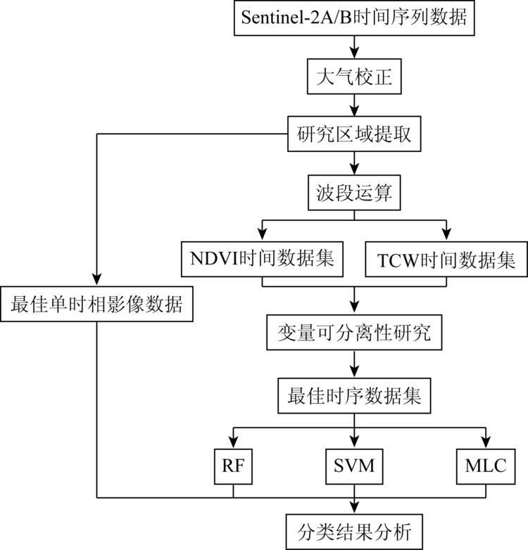
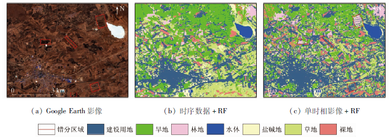
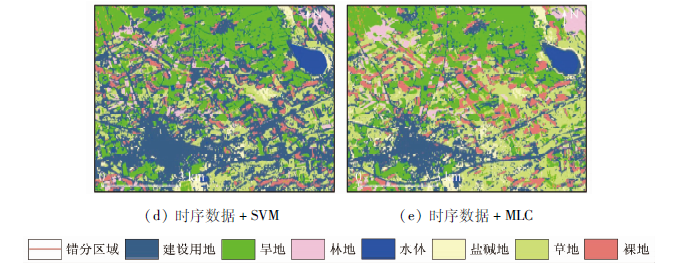
Land cover information in farming areas is the basis of land resource management and planning, which plays an important role in the rational development of land resources, adjustment of land use structure, and dynamic monitoring of land. Due to the complex land types and high heterogeneity in farming areas, the accuracy of land cover information extraction has been facing challenges. Therefore, this study used Sentinel-2A/B remote sensing data as the data source. Firstly, a normalized difference vegetation index (NDVI) time series data set and tasseled cap wetness (TCW) time series data set were constructed; Secondly, the J-M (Jeffries-Matusita) distance was used to analyze the separability of the surface features and select the best time series data combination of NDVI and TCW; Finally, combined with random forest (RF), support vector machine (SVM), maximum likelihood classification (MLC) and single phase remote sensing data, the classification of typical features in farming areas was studied, and the accuracy of classification results was evaluated and compared. The research results show that the classification accuracy of the time series data combined with the random forest classification algorithm is relatively high. The overall classification accuracy reaches 88.87%, and the Kappa coefficient reaches 0.855 7, which improves the classification accuracy by 10.05 percentage points and 0.209 3 respectively compared with that of the single remote sensing data. This fully demonstrates that the combination of time series data and random forest classification algorithm can effectively improve the classification accuracy of typical features in farming areas.
王德军, 姜琦刚, 李远华, 关海涛, 赵鹏飞, 习靖. 基于Sentinel-2A/B时序数据与随机森林算法的农耕区土地利用分类[J]. 国土资源遥感, 2020, 32(4): 236-243.
WANG Dejun, JIANG Qigang, LI Yuanhua, GUAN Haitao, ZHAO Pengfei, XI Jing. Land use classification of farming areas based on time series Sentinel-2A/B data and random forest algorithm. Remote Sensing for Land & Resources, 2020, 32(4): 236-243.
Zhang J, Zhang X, Tian L, et al. The support vector machine method for RS images’ classification in northwest arid area[J]. Science of Surveying and Mapping, 2017,42(1):49-52,58.
Ma Y, Jiang Q G, Meng Z G, et al. Classification of land use in farming area based on random forest algorithm[J]. Transactions of the Chinese Society for Agricultural Machinery, 2016,47(1):297-303.
Lin N, Jiang Q G, Yang J J, et al. Classifications of agricultural land use based on high-spatial ZY1-02C remote sensing images[J]. Transactions of the Chinese Society for Agricultural Machinery, 2015,46(1):278-284.
Wang Y R, Han P P, Guan S J, et al. Information extraction of Dracaena sanderiana planting area based on Landsat8 OLI data[J]. Remote Sensing for Land and Resources, 2019,31(1):133-140.doi: 10.6046/gtzyyg.2019.01.08.
[5]
Wardlow B D, Egbert S L. Large-area crop mapping using time-series MODIS 250 m NDVI data:An assessment for the U.S.Central Great Plains[J]. Remote Sensing of Environment, 2008,112(3):1096-1116.
[6]
Vintrou E, Desbrosse A, Bégué A, et al. Crop area mapping in West Africa using landscape stratification of MODIS time series and comparison with existing global land products[J]. International Journal of Applied Earth Observation and Geoinformation, 2012,14(1):83-93.
Zhu Y S, Zeng Y N, Zhang M. Extract of land use/cover information based on HJ satellites data and object-oriented classification[J]. Transactions of the Chinese Society of Agricultural Engineering, 2017,33(14):266-273.
Zhang M, Zeng Y N. Mapping paddy fields of Dongting Lake area by fusing Landsat and MODIS data[J]. Transactions of the Chinese Society of Agricultural Engineering, 2015,31(13):178-185.
Hao P Y, Niu Z, Wang L, et al. Multi-source automatic crop pattern mapping based on historical vegetation index profiles[J]. Transactions of the Chinese Society of Agricultural Engineering, 2012,28(23):123-131,297.
[10]
龚燃. 哨兵-2A光学成像卫星发射升空[J]. 国际太空, 2015(8):36-40.
Gong R. Sentinel-2A optical imaging satellite launched[J]. Space International, 2015(8):36-40.
Wu J, Lyu Y N, Li C B, et al. Fine classification of county crops based on multi-temporal images of Sentinel-2A[J]. Transactions of the Chinese Society for Agricultural Machinery, 2019,50(9):194-200.
[13]
Belgiu M, Drguţ L. Random forest in remote sensing:A review of applications and future directions[J]. ISPRS Journal of Photogrammetry and Remote Sensing, 2016,114:24-31.
Zhao L J, Tang P. Scalability analysis of typical remote sensing data classification methods:A case of remote sensing image scene[J]. Journal of Remote Sensing, 2016,20(2):157-171.
Yu X Q, Liu N, Li H, et al. Land cover classification based on linear spectral mixture decomposition combined with maximum likelihood classfication:A case study of Hongsipu Irrigation Area[J]. Remote Sensing for Land and Resources, 2010,22(1):96-100.doi: 10.6046/gtzyyg.2010.01.08.
Cheng H F, Zhang W B, Chen F. Advances in researches on application of remote sensing method to estimating vegetation coverage[J]. Remote Sensing for Land and Resources, 2008,20(1):13-18.doi: 10.6046/gtzyyg.2008.01.02.
Luo K S, Tao F L. Method for wetland type extraction using remote sensing combing obiect-oriented and tasseled cap transformation[J]. Transactions of the Chinese Society of Agricultural Engineering, 2017,33(3):198-203.
[18]
Wittke S, Yu X, Karjalainen M, et al. Comparison of two-dimensional multitemporal Sentinel-2 data with three-dimensional remote sensing data sources for forest inventory parameter estimation over a boreal forest[J]. International Journal of Applied Earth Observation and Geoinformation, 2019,76:167-178.
[19]
Sun Z P, Shen W M, Wei B, et al. Object-oriented land cover classification using HJ-1 remote sensing imagery[J]. Science China Earth Sciences, 2010,53(1):34-44.
doi: 10.1007/s11430-010-4133-6
Wang C Y, Liu Z J, Yan C Y. A experimental study on imaging spectrometer data feature selection and wheat type identification[J]. Journal of Remote Sensing, 2006,10(2):249-255.
doi: 10.11834/jrs.20060237
[21]
Breiman L. Random forests[J]. Machine Learning, 2001,45(1):5-32.
doi: 10.1023/A:1010933404324
[22]
Adam E, Mutanga O. Spectral discrimination of papyrus vegetation (Cyperus papyrus L.) in swamp wetlands using field spectrometry[J]. ISPRS Journal of Photogrammetry and Remote Sensing, 2009,64(6):612-620.
Liu S, Jiang Q G, Ma Y, et al. Object-oriented wetland classification based on hybrid feature selection method combining with Relief F,multi-objective genetic algorithm and random forest[J]. Transactions of the Chinese Society for Agricultural Machinery, 2017,48(1):119-127.
He Y, Huang C, Li H, et al. Land-cover classification of random forest based on Sentinel-2A image feature optimization[J]. Resources Science, 2019,41(5):992-1001.
doi: 10.18402/resci.2019.05.15
 2020, Vol. 32
  ), 姜琦刚2, 李远华2, 关海涛1, 赵鹏飞1, 习靖2