Ecological environment in the Dongting Lake basin over the past decade: Spatio-temporal dynamic characteristics and their influencing factors from 2010 to 2019
LI Shijie(), FENG Huihui(), WANG Zhen, YANG Zhuolin, WANG Shu
School of Earth Science and Information Physics, Central South University, Changsha 410083, China
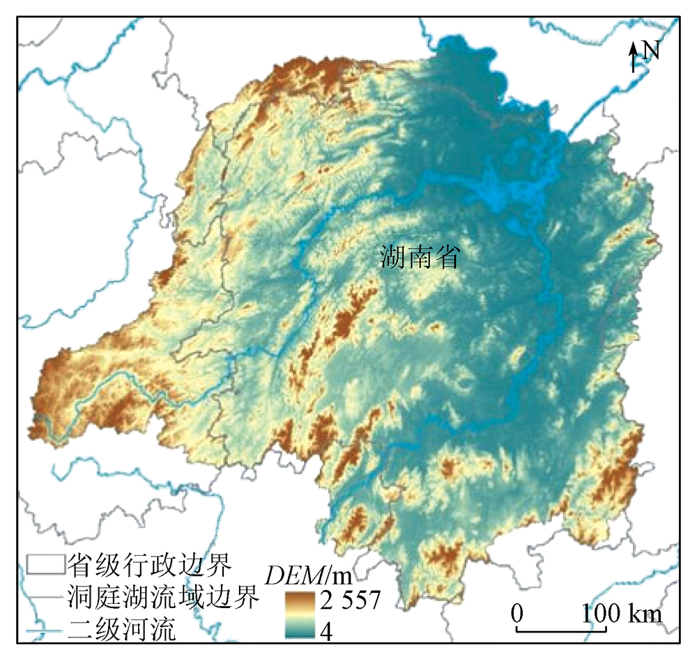
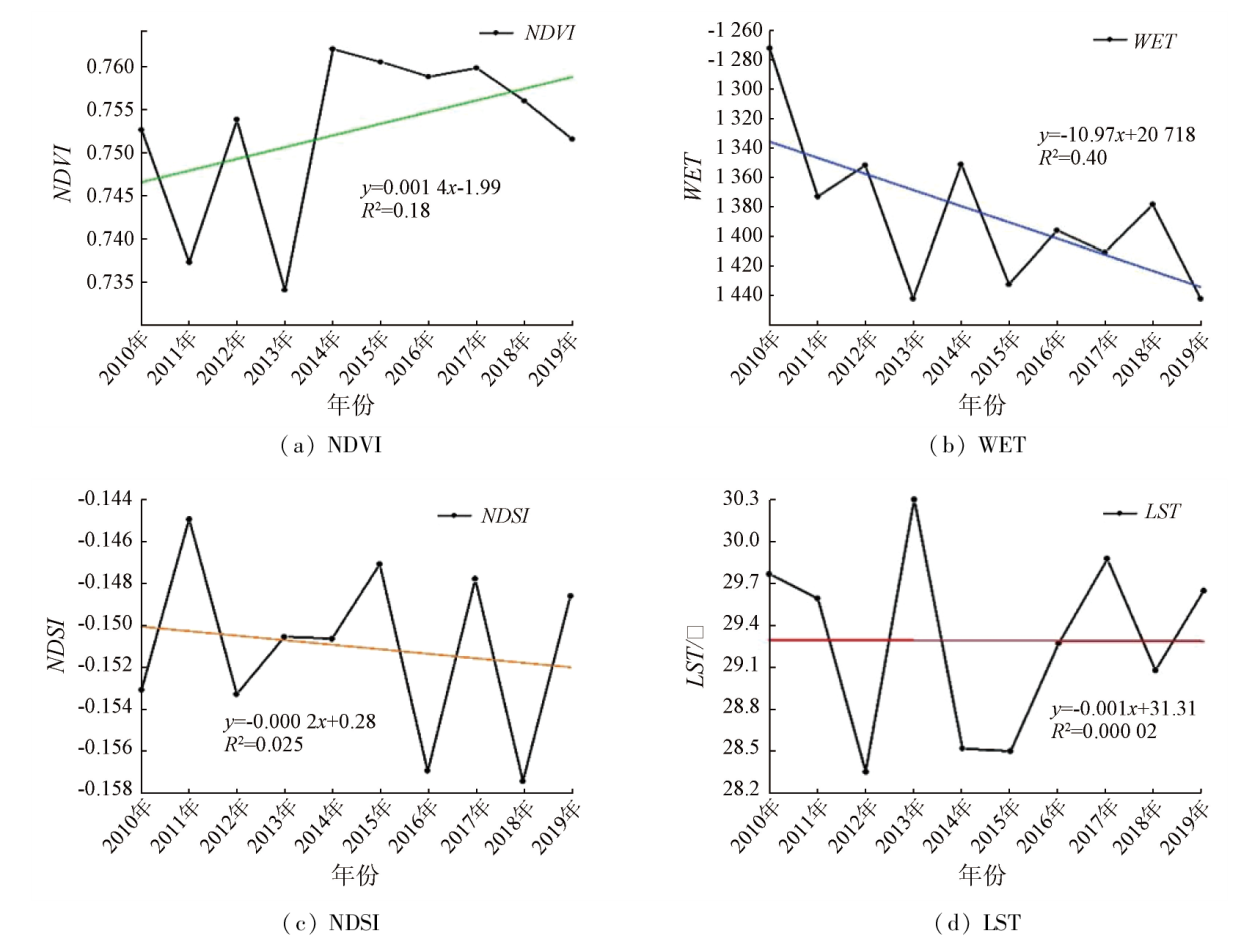
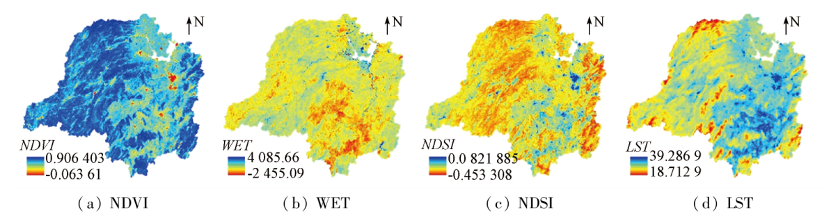
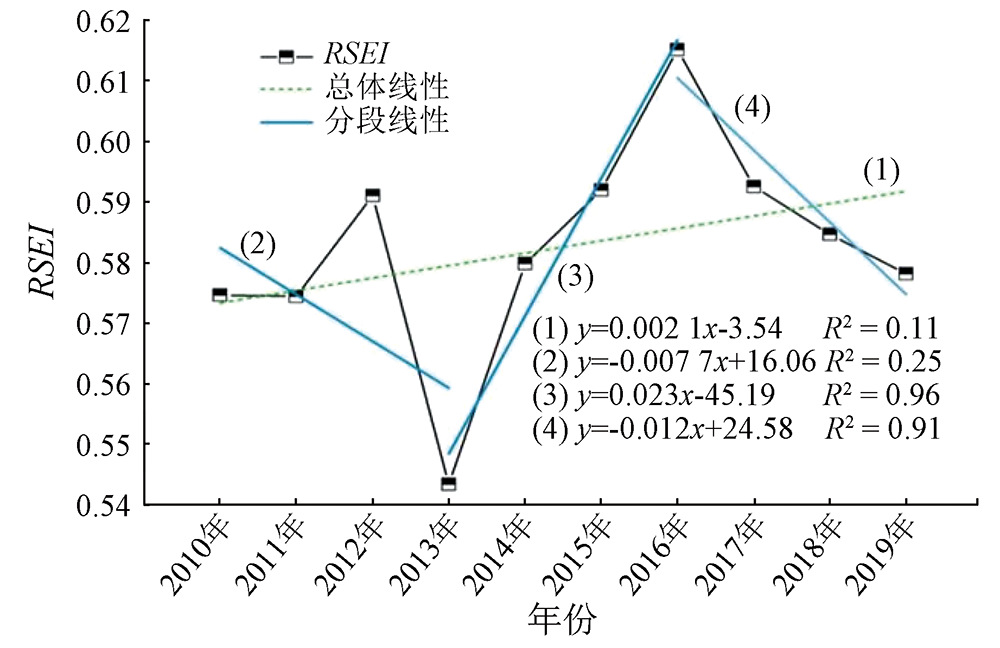
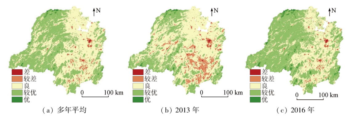
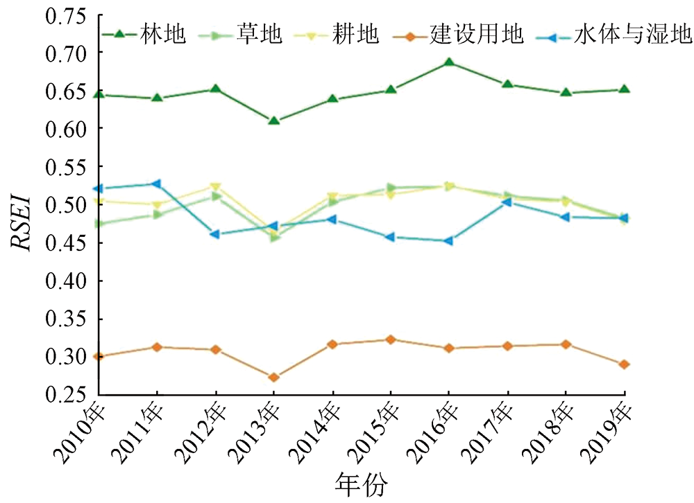
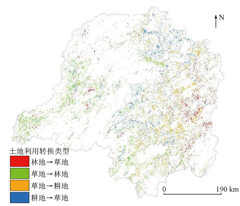
Since the Dongting Lake basin is a significant ecological zone in the middle and lower reaches of the Yangtze River, quantitative monitoring and evaluation of its ecological environment serve as a prerequisite for regional ecological conservation, restoration, and governance. Using MODIS products involving 2010—2019 remote sensing data, this study constructed the remote sensing ecological index (RSEI) for the Dongting Lake basin based on four ecological indices: greenness, humidity, dryness, and heat. Furthermore, this study explored the spatio-temporal dynamic characteristics of the ecological environment in the basin and their influencing factors. The results show that: ① From 2010 to 2019, the Dongting Lake basin exhibited an elevated greenness index, a reduced humidity index, and relatively stable dryness and heat indices; ② The ecological environment of the Dongting Lake basin was generally satisfactory, with a mean annual RSEI of 0.58, indicating a fluctuating growth. In terms of spatial distribution, the ecological environment in the western and surrounding areas was superior to that in the eastern and central areas; ③ There were strong correlations between RSEI and precipitation, air temperature, elevation, and land cover. The RSEI was the highest (0.65) for forest land and the lowest (0.31) for construction land. As for the two primary land conversion types (grassland → forest land, arable land → grassland) in the basin, the former type could improve the regional ecological environment (ΔRSEI=0.002 5, a contribution rate of 46.3%), whereas the latter type might lead to ecological environment deterioration (ΔRSEI=-0.000 4, contribution rate: 44.44%). The results of this study, assisting in deeply understanding the spatio-temporal characteristics of the ecological environment in the basin and their internal driving mechanisms and facilitating scientific land planning and ecological environment governance, hold critical theoretical and practical significance.
李世杰, 冯徽徽, 王珍, 杨卓琳, 王姝. 2010—2019年间洞庭湖流域生态环境状况时空动态特征及影响因素[J]. 自然资源遥感, 2024, 36(1): 179-188.
LI Shijie, FENG Huihui, WANG Zhen, YANG Zhuolin, WANG Shu. Ecological environment in the Dongting Lake basin over the past decade: Spatio-temporal dynamic characteristics and their influencing factors from 2010 to 2019. Remote Sensing for Natural Resources, 2024, 36(1): 179-188.
Peng Y, He G J, Zhang Z M, et al. Eco-environmental dynamic monitoring and assessment of rare earth mining area in Southern Ganzhou Using Remote Sensing[J]. Acta Ecologica Sinica, 2016, 36(6):1676-1685.
Li A J, Zhu X, Zhao B Y, et al. Preliminary study on construction of indicator system of dynamic monitoring and assessment of eco-environments[J]. Environmental Monitoring in China, 2004, 20(4):35-38.
[3]
Miao C L, Sun L Y, Yang L. The studies of ecological environmental quality assessment in Anhui Province based on ecological footprint[J]. Ecological Indicators, 2016, 60:879-883.
doi: 10.1016/j.ecolind.2015.08.040
Shao B, Chen X P. AHP analysis on the integrated assessment for the eco-environment of Gansu Province[J]. Journal of Arid Land Resources and Environment, 2005, 19(4):29-32.
Ye Y P, Liu L J. A preliminary study on assessment indicator system of provincial eco-environmental quality in China[J]. Research of Environmental Sciences, 2000, 13(3):33-36.
Li Y L, Zhu B L, Wang L, et al. Designing and application of comprehensive index method based ecological environment quality comprehensive evaluation system[J]. Science of Surveying and Mapping, 2005, 30(1):89-91,111.
Yu X F. The research of environment quality change of Karst area based on remote sensing based ecological index[D]. Guiyang: Guizhou Normal University, 2018:1-2.
Yao Y, Wang S X, Zhou Y, et al. The application of ecological environment index model on the national evaluation of ecological environment quality[J]. Remote Sensing Information, 2012, 27(3):93-98.
Wang Z H, Ma H Z, Zhou D J, et al. Integrated evaluation of eco-environment based on RS/GIS:A case study of the south-to-north water transfer project in Yalongjiang River[J]. Journal of Salt Lake Research, 2007, 15(1):1-4.
Sun C X, Yang F, Hu J. New ecological index evaluation based on remote sensing data[J]. Bulletin of Surveying and Mapping, 2021,(11):12-15,53.
doi: 10.13474/j.cnki.11-2246.2021.330
Yue H, Liu Y, Zhu R. Monitoring ecological environment change based on remote sensing ecological index in Shendong mining area[J]. Bulletin of Soil and Water Conservation, 2019, 39(2):101-107,114.
Wang T, Zhang X P, Li Z X, et al. Temporal and spatial distribution characteristics of meteorological drought for recent 52 years in Dongting Lake basin[J]. Resources and Environment in the Yangtze Basin, 2016, 25(3):514-522.
Deng Z H, Dai L Q, Deng B, et al. Spatial-temporal evolution of water resources carrying capacity in Dongting Lake basin[J]. Economic Geography, 2021, 41(5):186-192.
Fang J Y, Guo Z D, Piao S L, et al. Estimation of carbon sinks of tervestrial vegetation in China from 1981 to 2000[J]. Scientia in Sinica(Series D(Earth Sciences)), 2007, 37(6):804-812.
Yang J Y, Wu T, Pan X Y, et al. Ecological quality assessment of Xiongan New Area based on remote sensing ecological index[J]. Chinese Journal of Applied Ecology, 2019, 30(1):277-284.
Chen C, Jiang T, Liu X L. Research on remote sensing image fusion methods based on tasseled cap transformation[J]. Science of Surveying and Mapping, 2009, 34(3):105-106,163.
[19]
Zhang X, Schaaf C B, Friedl M A, et al. MODIS tasseled cap transformation and its utility[C]// IEEE International Geoscience and Remote Sensing Symposium Toronto,Ontario,Canada.IEEE, 2002:1063-1065.
Zuo L, Sun G L, Lu J J, et al. MODIS-based comprehensive assessment and spatial-temporal change monitoring of ecological quality in Beijing-Tianjin-Hebei region[J]. Remote Sensing for Natural Resources, 2022, 34(2):203-214.doi:10.6046/zrzyyg.2021224.
Wang J, Zhao M D, Li J B, et al. Dynamic monitoring and driving forces of eco-environmental quality in the Qinba Mountains based on MODIS time-series data[J]. Mountain Research, 2021, 39(6):830-841.
Yin J P. Ecological environment evaluation based on remote sensing ecological index in Pingshuo Open-pit Mine[J]. Opencast Mining Technology, 2021, 36(1):45-47.
[23]
Feng H H, Liu Y B. Trajectory based detection of forest-change impacts on surface soil moisture at a basin scale Poyang Lake Basin,China[J]. Journal of Hydrology, 2014, 514:337-346.
doi: 10.1016/j.jhydrol.2014.04.044
[24]
Feng H H, Zou B. A greening world enhances the surface-air temperature difference[J]. Science of the Total Environment, 2019, 658:385-394.
doi: 10.1016/j.scitotenv.2018.12.210
Fu J, Qin J X, Zhang M, et al. Spatial-temporal variations of vegetation coverage in the Lake Dongting Basin from 2001 to 2013[J]. Journal of Geo-Information Science, 2016, 18(9):1209-1216.
Sang G Q, Tang Z G, Deng G, et al. Study on vegetation change in Hunan Province based on MODIS NDVI time series data[J]. Resources and Environment in the Yangtze Basin, 2021, 30(5):1100-1109.
Miao X H, Liang Q O. Analysis of ecological environment changes in Yongjiang River basin based on remote sensing ecological index[J]. Resources and Environment in the Yangtze Basin, 2021, 30(2):427-438.
Song H M, Xue L. Dynamic monitoring and analysis of ecological environment in Weinan City,Northwest China based on RSEI model[J]. Chinese Journal of Applied Ecology, 2016, 27(12):3913-3919.
Lei Q, Zhang X P, Li Z X, et al. Impacts of meteorological extreme drought during growing season on vegetation cover in Dongting Lake basin[J]. Resources and Environment in the Yangtze Basin, 2020, 29(1):187-199.
Yang L, Deng M, Wang J L, et al. Spatial-temporal evolution of land use and ecological risk in Dongting Lake Basin during 1980—2018[J]. Acta Ecologica Sinica, 2021, 41(10):3929-3939.
Kong L Q, Zheng H, Ouyang Z Y. Ecological protection and restoration of forest,wetland,grassland and cropland based on the perspective of ecosystem services:A case study in Dongting Lake Watershed[J]. Acta Ecologica Sinica, 2019, 39(23):8903-8910.
Liu Y, Dang C Y, Yue H, et al. Comparison between modified remote sensing ecological index and RSEI[J]. National Remote Sensing Bulletin, 2022, 26(4):683-697.
doi: 10.11834/jrs.20229338
Sun Y, Yi L, Yin S H. Vegetation cover change in Dongting Lake basin and its coordination governance[J]. Economic Geography, 2022, 42(4):190-201.
doi: 10.15957/j.cnki.jjdl.2022.04.021
Han Y, Mao Y F, Yang L, et al. Dynamic responses of habitat quality to LUCC in the Dongting Lake Basin[J]. Central South University of Forestry and Technology, 2023, 43(6):148-157.
 2024, Vol. 36
  ), 冯徽徽(