Identification and classification of land types of alpine wetlands based on spectral coupling
NIE Shiyin1(), LIU Yansong1,2(), LI Huiling1, XUE Kailun1, SHEN Duheng1, HE Boyu2,3
1. College of Earth and Planetary Sciences, Chengdu University of Technology, Chengdu 610059, China 2. Key Laboratory of Earth Exploration and Information Technology of Ministry of Education(Chengdu University of Technology), Chengdu 610059, China 3. Sichuan Sumhope Spatial Technology Co., Ltd, Chengdu 610094, China
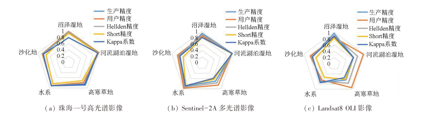
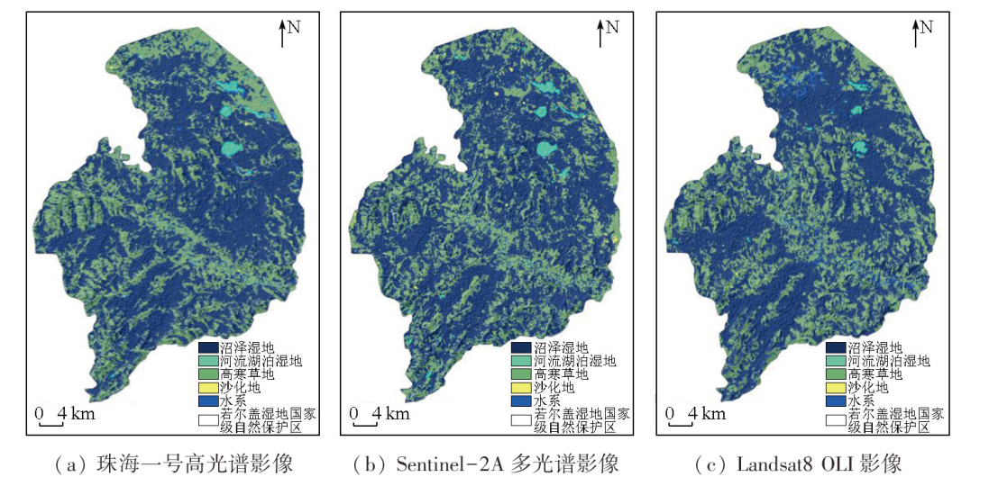
Alpine wetlands, a critical part of the natural ecosystem in the Qinghai-Tibet Plateau, serve as extremely significant water conservation and climate regulation areas in China. Accurately extracting land cover information of alpine wetlands is crucial for local ecological security monitoring and protection. This study performed object-oriented classification of the data from the Zoige wetland, including the Zhuhai-1 hyperspectral remote sensing image, Sentinel-2A remote sensing image, and Landsat-8 OLI image, integrated with spectral, textural, and topographic features. The results show that the overall data classification accuracy of the three images exceeded 85 %, with a Kappa coefficient above 68 %. The optimal classification result was observed in the Zhuhai-1 hyperspectral remote sensing image. The three images showed generally consistent data classification results, with marsh wetlands being the dominant land type. They indicated roughly the same distribution of riverine and lacustrine wetlands and slightly varying distributions of alpine grasslands, with minor area differences. Additionally, they displayed minimally different distributions of desertified land and almost the same hydrographic net distribution except for slightly different tributary distributions. This study fully explores the combinations of spectral features favorable for image classification, improving the identification accuracy of remote sensing images and providing technical support for the conservation of alpine wetlands.
聂诗音, 刘严松, 李会玲, 薛凯伦, 沈杜衡, 何博宇. 基于图谱耦合的高寒湿地土地类型识别与分类[J]. 自然资源遥感, 2025, 37(2): 204-211.
NIE Shiyin, LIU Yansong, LI Huiling, XUE Kailun, SHEN Duheng, HE Boyu. Identification and classification of land types of alpine wetlands based on spectral coupling. Remote Sensing for Natural Resources, 2025, 37(2): 204-211.
Hou M J, Yin J P, Ge J, et al. Land cover remote sensing classification method of alpine wetland region based on random forest algorithm[J]. Transactions of the Chinese Society for Agricultural Machinery, 2020, 51(7):220-227.
Guo C Q. Research on ecological restoration optimization of alpine wetland in Zoige Plateau based on multi-objective genetic algorithm[D]. Beijing: Beijing Forestry University, 2021.
Li J, Jiang W G. Application of hyperspectral remote sensing in wetland monitoring and classification[C]// Proceedings of the 10th National Optoelectronic Technology Academic Exchange Conference, 2012:152-153.
Wang S Y. Extraction of wetlands information using multi-temporal remote sensing images in Shuangtai Estuary area of Liaoning Province[D]. Chengdu: Chengdu University of Technology, 2016.
Ruan R Z, Feng X Z. Identification on wetland based on GIS and multi-temporal remote sensing images[J]. Remote Sensing Information, 2005, 20(2):20-23,69.
Zhang L, Gong Z N, Wang Q W, et al. Wetland mapping of Yellow River Delta wetlands based on multi-feature optimization of Sentinel-2 images[J]. Journal of Remote Sensing, 2019, 23(2):313-326.
Chang W T, Wang H, Ning X G, et al. Extraction of Zhalong wetlands information based on images of Sentinel-2 red-edge bands and Sentinel-1 Radar bands[J]. Wetland Science, 2020, 18(1):10-19.
Qiao W Y. Research on Yellow River estuary wetland classification based on hyperspectral remote sensing images[D]. Qingdao: Shandong University of Science and Technology, 2020.
Yao J P, Yang L K, Chen T, et al. Consecutive monitoring of the Poyang Lake wetland by integrating Sentinel-2 with Sentinel-1 and Landsat8 data[J]. Remote Sensing Technology and Application, 2021, 36(4):760-776.
Zhang X B, Shi J, Ou M W, et al. Monitoring and analysis of wetland change in East Dongting Lake based on Landsat8 remote sensing data[J]. Shanghai Land and Resources, 2021, 42(1):24-28.
Yu X J. Fine scale impervious surface extraction method research based on coupled spectral and spatial features[D]. Beijing: University of Chinese Academy of Sciences (Institute of Remote Sensing and Digital Earth Chinese Academy of Sciences), 2016.
Zuo D D, Luo P, Yang H, et al. Assessing the space neighborhood effects and the protection effectiveness of a protected area:A case study from Zoige Wetland National Nature Reserve[J]. Chinese Journal of Applied and Environmental Biology, 2019, 25(4):854-861.
Fei S M, Cui L J, He Y P, et al. A background study of the wetland ecosystem research station in the Ruoergai Plateau[J]. Journal of Sichuan Forestry Science and Technology, 2006, 27(2):21-29.
Wu G J, Lin H Y, Ning Y, et al. Landscape pattern dynamic of Zoige Wetland during 12 years based on functional zone division[J]. Journal of West China Forestry Science, 2017, 46(5):6-12.
Zhang Z Y, Wang P, Zhu L, et al. Application of the eCognition technology to information extraction from high resolution remote sensing image[J]. Land and Resources Informatization, 2007(2):15-17,33.
Zheng S D, Zheng J H, Shi M H, et al. Classification of cultivated Chinese medicinal plants based on fractal theory and gray level co-occurrence matrix textures[J]. Journal of Remote Sensing, 2014, 18(4):868-886.
Chen Y H, Feng T, Shi P J, et al. Classification of remot sensing image based on object oriented and class rules[J]. Geomatics and Information Science of Wuhan University, 2006, 31(4):316-320.
 2025, Vol. 37
  ), 刘严松1,2(