Extraction of buildings in remote sensing imagery based on multi-level segmentation and classification hierarchical model and feature space optimization
Tao DANG1,2, Qi SONG1, Yong LIU2, Anjian XU1, Bo XU1, Honggang ZHANG1
1. Xi’an Information Technique Institute of Surveying and Mapping, Xi’an, 710054, China; 2. College of Earth and Enviromental Sciences, Lanzhou University, Lanzhou 730000, China
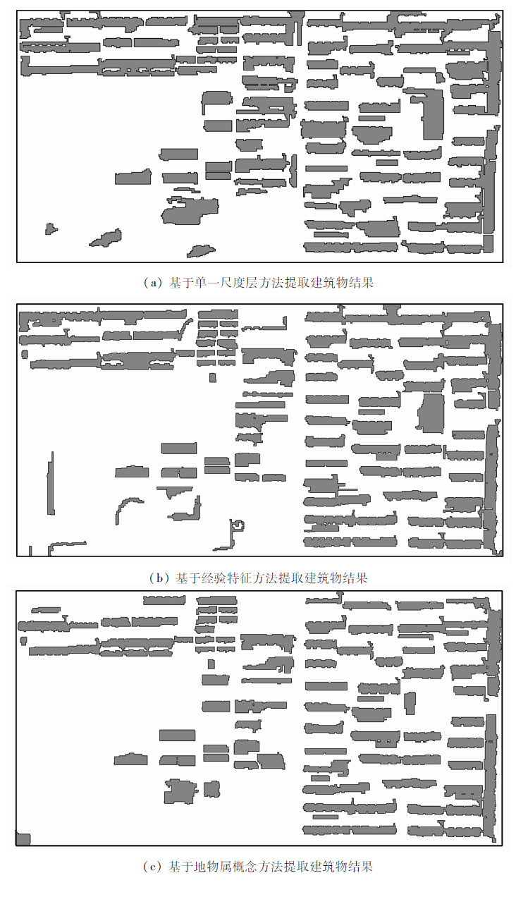
In view of the problems of scale effect, spectral diversity and classification feature optimization in the extraction of urban objects information from high spatial resolution remote sensing images,the authors, based on the object-based image analysis method and combined with data mining and machine learning,propose a multi-level segmentation and classification hierarchical model and its feature space optimization method for building extraction. First, according to the multi-scale characteristics of remote sensing information, a hierarchical relationship is set up for the difference of features of ground objects, and then a hierarchical structure based on information segmentation and classification is established based on the characteristics of spectral diversity to define the subtypes of ground objects. After that, the proposed Relief F-PSO combination feature selection method is used. Finally,on the basis of multiscale segmentation and feature optimization, the water surface distribution is obtained based on the random forest model, and finally the building information is extracted by the J48 decision tree algorithm. Experimental results show that the method can utilize a small number of image feature attributes to get high-precision building extraction results.
党涛, 宋起, 刘勇, 徐安建, 徐波, 张宏刚. 基于多层次分割分类模型及其特征空间优化的建筑物提取方法[J]. 国土资源遥感, 2019, 31(3): 111-122.
Tao DANG, Qi SONG, Yong LIU, Anjian XU, Bo XU, Honggang ZHANG. Extraction of buildings in remote sensing imagery based on multi-level segmentation and classification hierarchical model and feature space optimization. Remote Sensing for Land & Resources, 2019, 31(3): 111-122.
Wang J, Qin Q M, Ye X , et al. A survey of building extraction methods from optical high resolution remote sensing imagery[J]. Remote Sensing Technology and Application, 2016,31(4):653-662.
Guo Y F, Zhang J, Wei D . The research of object-oriented building contour extraction of high-resolution remote sensing image[J].Bulletin of Surveying and Mapping, 2014(s2):300-303.
Tang Y Y, Ye H P, Wu S J , et al. Building classification and extraction form remote sensing image based on wave range and shape features[J]. Journal of Logistical Engineering University, 2016,32(1):93-96.
Wang X D, Duan F Z, Qu X Y , et al. Building extraction based on UAV imagery data with the synergistic use of objected-based method and SVM clsssifier[J]. Remote Sensing for Land and Resources, 2017,29(1):97-101.doi: 10.6046/gtzyyg.2017.01.15.
[7]
Turker M, Koc-San D . Building extraction from high-resolution optical spaceborne images using the integration of support vector machine (SVM) classification,Hough transformation and perceptual grouping[J]. International Journal of Applied Earth Observation and Geoinformation, 2016,34:58-69.
[8]
Dornaika F, Moujahida A, Merabet Y E , et al. Building detection from orthophotos using a machine learning approach:An empirical study on image segmentation and descriptors[J]. Expert Systems With Applications, 2016,58:130-142.
[9]
Chen L, Zhao S H, Han W Q , et al. Building detection in an urban area using LiDAR data and QuickBird imagery[J]. International Journal of Remote Sensing, 2012,33:5135-5148.
[10]
Awrangjeb M, Zhang C, Fraser C S . Automatic extraction of building roofs using LiDAR data and multispectral imagery[J]. ISPRS Journal of Photogrammetry and Remote Sensing, 2013,83:1-18.
[11]
胡婷 . 遥感图像典型地物特征提取的尺度效应研究[D]. 西安:西北大学, 2010.
Hu T . The Study of Scale Effects in Typical Objects’ Feature Extraction from Remote Sensing Image[D]. Xi’an:Northwest University, 2010.
Huang H P, Wu B F . Analysis of the mutli-scale characteristics with objects extraction[J]. Remote Sensing Technology and Application, 2003,18(5):276-281.
Li Q, Gao X Z, Zhang T , et al. Optimal segmentation scale selection and evaluation for multi-layer image recognition and classification[J]. Journal of Geo-Information Science, 2011,13(3):409-416.
Wu L M, Zuo X Q, Ni S , et al. Special Information Extraction Technology and Application of Satellite Remote Sensing Images[M]. Chengdu: Southwest Jiaotong University press, 2013.
Lyu F H, Shu N, Gong Y , et al. Regular building extraction from high resolution image based on multilevel-features[J]. Geomatics and Information Science of Wuhan University, 2017,42(5):656-660.
Wu W, Luo J C, Shen Z F , et al. Building extraction from high resolution remote sensing imagery based on spatial-spectral method[J]. Geomatics and Information Science of Wuhan University, 2012,37(7):800-805.
Tan Q L . Urban building extraction from VHR multi-spectral images using object-based classification[J]. Acta Geodaetica et Cartographica Sinica, 2010,39(6):618-623.
[18]
蒋胜利 . 高维数据的特征选择与特征提取研究[D]. 西安:西安电子科技大学, 2011.
Jiang S L . Research on Feature Selection and Feature Extraction for High-Dimensional Data[D]. Xi’an:Xidian University, 2011.
Liu S, Jiang Q G, Ma Y , et al. Object-oriented wetland classification based on hybrid feature selection method combing with Relief F,multi-objective genetic algorithm and random forest[J]. Transactions of the Chinese Society for Agricultural Machinery, 2017,48(1):119-127.
Xue Z Y, Liu X Q . Feature selection method for object-oriented building targets recognition based on ReliefF,GA and SVM[J]. Engineering of Surveying and Mapping, 2017,26(2):52-56.
Wu Q . Study on Monitoring Method for Ecological Construction of Water and Soil Conservation Based On High-Resolution Remote Sensing Images[D]. Beijing:Beijing Forestry University, 2007.
Li X X, Wang Y J . Coal mine subsidence area extraction for high-resolution remote sensing imagery based on object-oriented classification method[J]. Computer Engineering and Application, 2011,47(23):239-241.
Xiao Y, Jiang Q G, Wang B , et al. Object based land-use classification based on hybrid feature selection method of combining ReliefF and PSO[J]. Transaction of the Chinese Society of Agricultural Engineering, 2016,32(4):211-215.
[24]
Liu Y, Bian L, Meng Y , et al. Discrepancy measures for selecting optimal combination of parameter values in object-based image analysis[J].ISPRS Journal of Photogrammetry and Remote Sensing, 2012(68):144-156.
Sun Y Y, Zhao J L, Wang M M , et al. Land cover information extraction from remote sensing images using object-based image analysis method integrated with decision tree[J]. Remote Sensing for Land and Resources, 2016,28(4):156-63.doi: 10.6046/gtzyyg.2016.04.24.
 2019, Vol. 31