Exploring the dynamic evolution of vegetation cover in Xichuan County, Henan Province by integrating multisource remote sensing data
GE Liling1(), WANG Lu2()
1. Henan Provincial National Land Space Survey and Planning Institute, Zhengzhou 450016, China 2. School of Surveying and Land Information Engineering, Henan Polytechnic University, Jiaozuo 454000, China
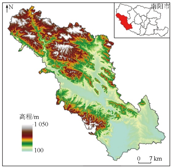
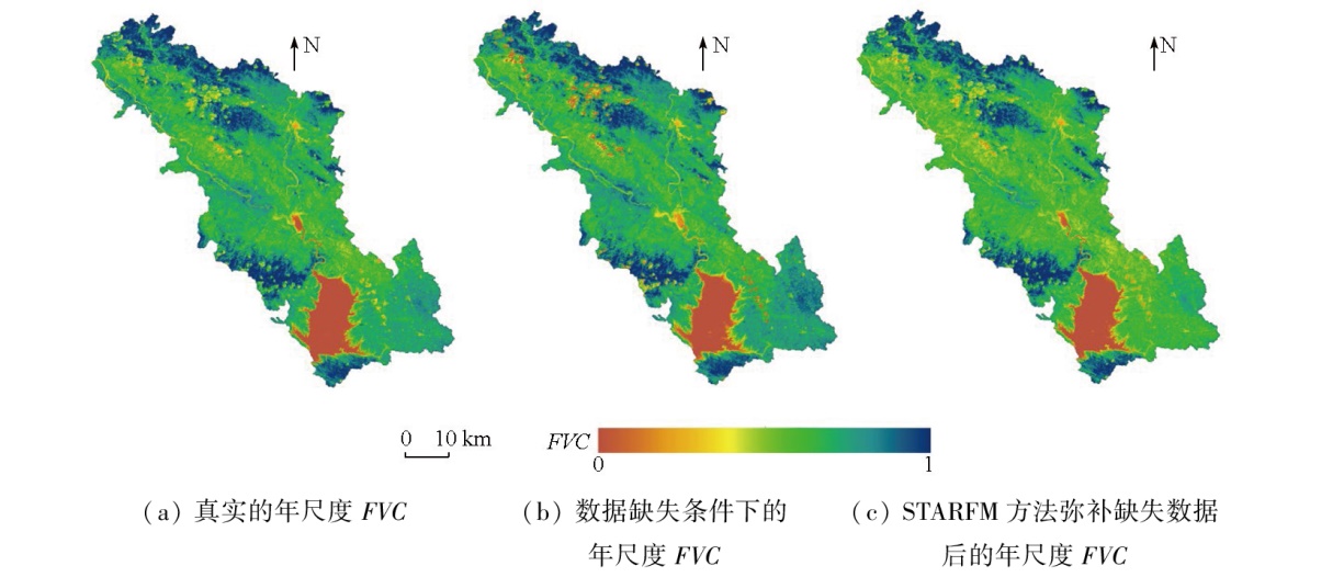
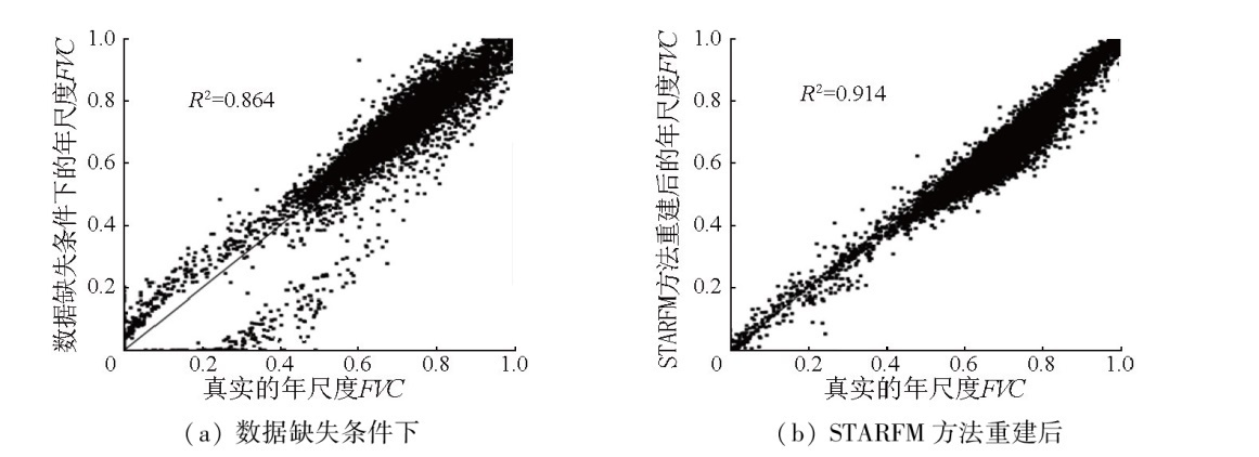
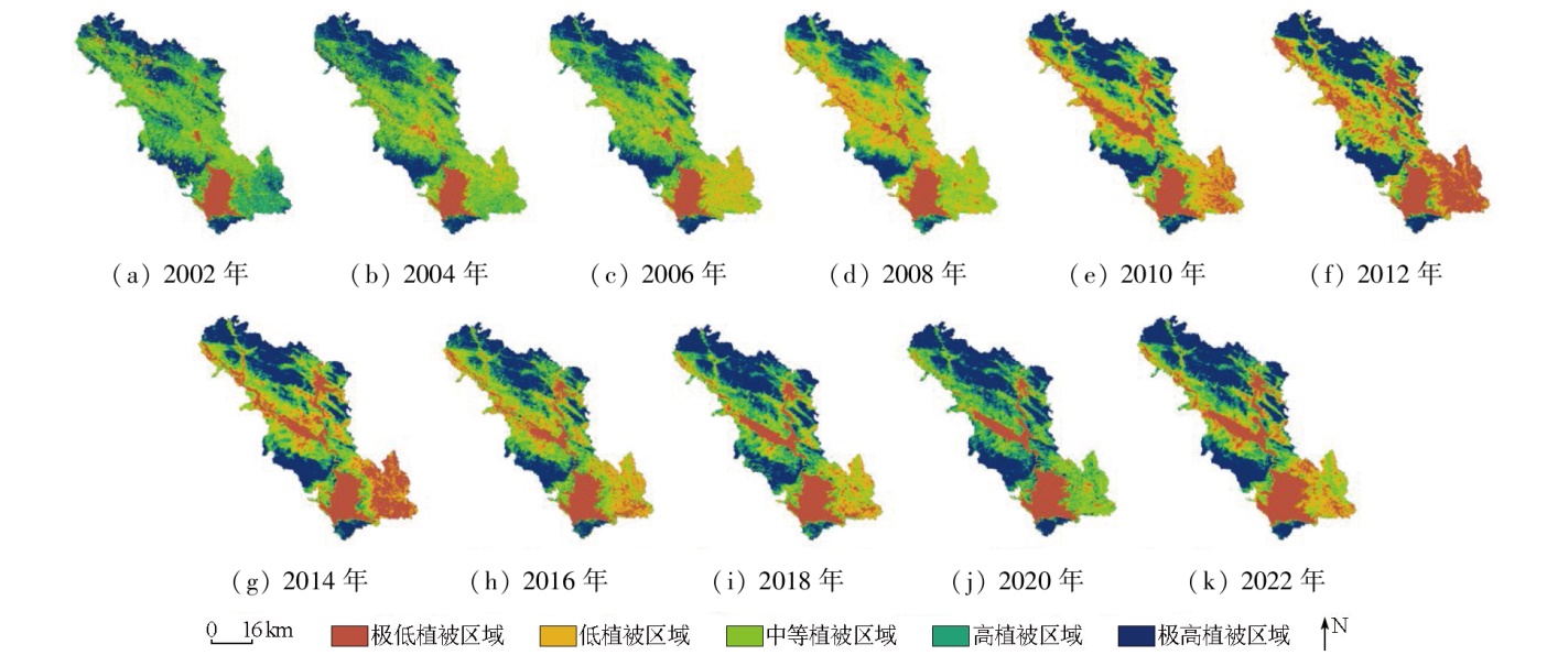
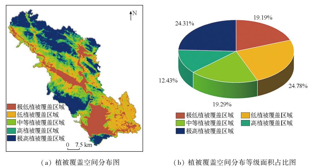
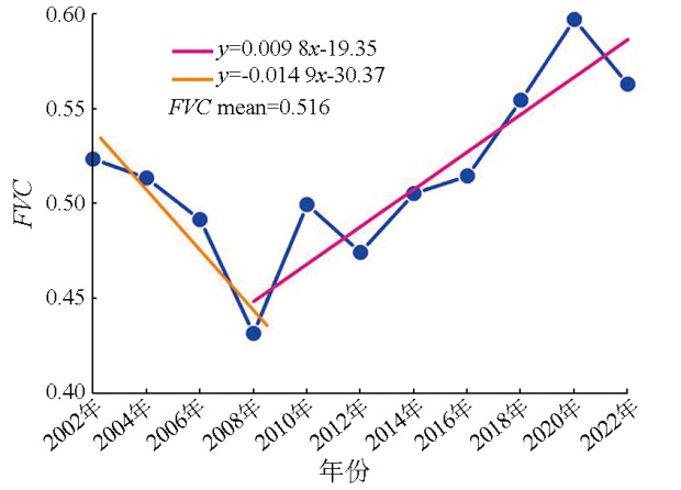
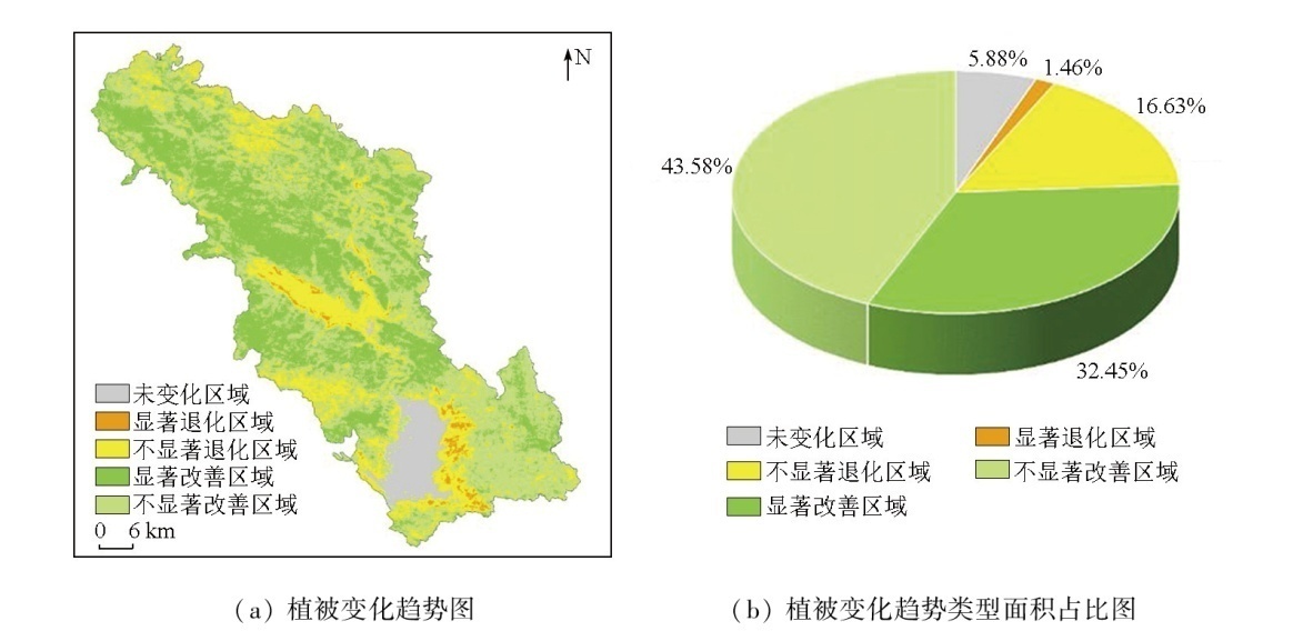
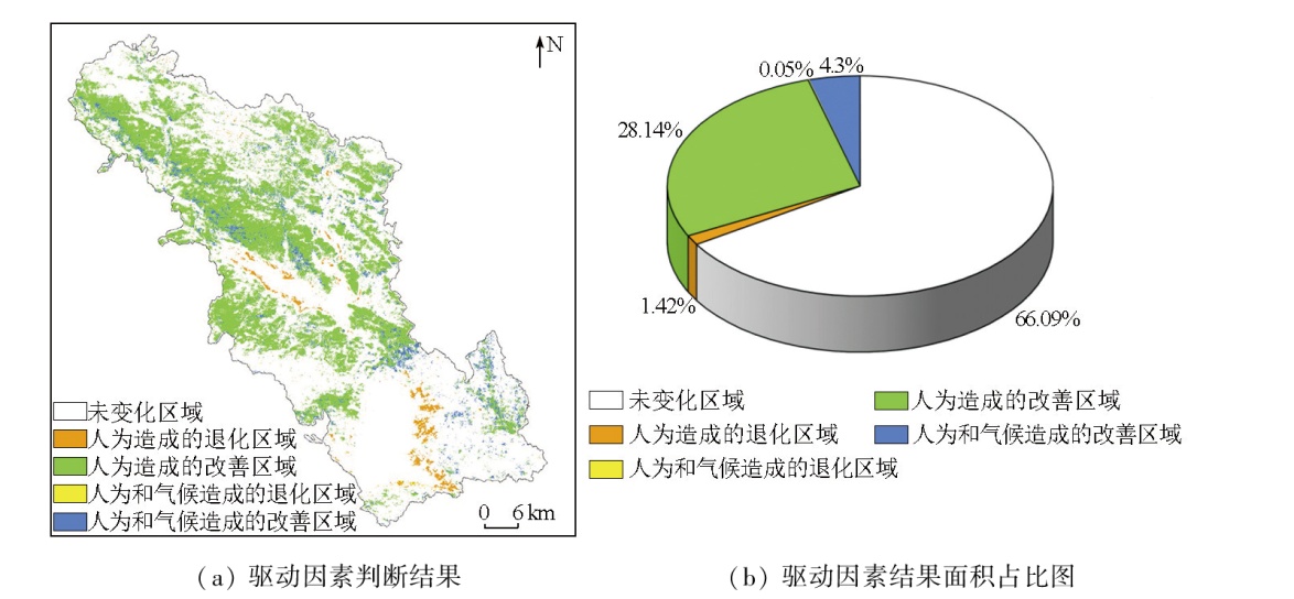
Xichuan County serves as a primary water source area for the middle route of the South-to-North Water Diversion Project. Investigating the spatiotemporal variations and driving mechanism of vegetation cover in Xichuan County is significant for the ecological restoration of the county and the environmental protection of the water source area for the middle route. Based on available Landsat and MODIS data, this study constructed long time-series fractional vegetation cover (FVC) data for Xichuan County from 2002 to 2022 using the spatiotemporal adaptive reflection fusion model (STARFM) and the dimidiate pixel model. In combination with regression and trend analyses, the geodetector model, and correlation analysis, this study explored the spatiotemporal variations and driving mechanism of vegetation cover in Xichuan County during the study period. The results indicate that the coefficient of determination (R2) between the STARFM-reconstructed and real annual-scale FVC reached 0.914, an improvement of 0.05 compared to 0.864 under conditions of data missing. Therefore, the STARFM can provide a reliable data basis for more accurately investigating the dynamic evolution of vegetation cover in Xichuan County. From 2002 to 2022, the vegetation cover in Xichuan County was ordinary, with an average FVC value of 0.516, characterized by higher vegetation cover in the northwest compared to the southeast. The vegetation cover in Xichuan County showed an overall improvement trend, with an improved area representing 76.02 %, primarily covering the northwestern and southeastern portions of Xichuan County. In contrast, the degraded area represented 23.98 %, primarily covering the areas surrounding the Danjiangkou reservoir, Danjiang River, and Xishui branch. The spatial heterogeneity of vegetation cover in Xichuan County was predominantly influenced by elevation and slope, followed by soil type and average temperature, with minimal impacts from soil texture and average rainfall. The improvement and degradation of vegetation cover in Xichuan County were principally caused by anthropogenic factors, with minimal influence from climate factors. The primary anthropogenic factor denotes the middle route of the South-to-North Water Diversion Project, which contributed significantly to vegetation growth rather than inhibitory effects.
葛利玲, 王璐. 融合多源遥感数据的河南省淅川县植被动态演变研究[J]. 自然资源遥感, 2025, 37(3): 192-202.
GE Liling, WANG Lu. Exploring the dynamic evolution of vegetation cover in Xichuan County, Henan Province by integrating multisource remote sensing data. Remote Sensing for Natural Resources, 2025, 37(3): 192-202.
Wu C G, Zhou Z X, Xiao W F, et al. Dynamic monitoring of vegetation coverage in Three Gorges Reservoir Area based on MODIS NDVI[J]. Scientia Silvae Sinicae, 2012, 48(1):22-28.
Li J, Lian Z Q, Dou M, et al. Spatio-temporal distribution characteristics of water quality and influencing factors in Danjiang Reservoir Area[J]. South-to-North Water Transfers and Water Science & Technology, 2023, 21(1):181-189.
Xiao Y N, Cheng J H, Mo X C, et al. Spatio-temporal variation of phytoplankton community and its relationship with environmental factors in Danjiangkou Reservoir[J]. Journal of Lake Sciences, 2023, 35(3):821-832.
Cui D Y, Wang S D, Zhang X J. A remote sensing-based study on change in land use and vegetation cover in Xiong’an New Area from 1991 to 2021[J]. Remote Sensing for Natural Resources, 2023, 35(4):214-225.doi:10.6046/zrzyyg.2022311.
[5]
Chu H, Venevsky S, Wu C, et al. NDVI-based vegetation dynamics and its response to climate changes at Amur-Heilongjiang River Basin from 1982 to 2015[J]. Science of the Total Environment, 2019,650:2051-2062.
[6]
Guo Y, Zhang X, Wang Q, et al. Temporal changes in vegetation around a shale gas development area in a subtropical Karst Region in southwestern China[J]. Science of the Total Environment, 2020,701:134769.
Zhong A Y, Bao C, Hu C M. Spatiotemporal dynamic change monitoring of NDVI in mining areas of Dexing from the perspective of ecological restoration[J]. Environmental Engineering, 2024, 42(5):122-130.
[8]
Huo H, Sun C. Spatiotemporal variation and influencing factors of vegetation dynamics based on Geodetector:A case study of the northwestern Yunnan Plateau,China[J]. Ecological Indicators, 2021,130:108005.
Miao L J, Zhang Y Y, Chuai X W, et al. Effects of climatic factors and their time-lag on grassland NDVI in Asian drylands[J]. Chinese Journal of Plant Ecology, 2023, 47(10):1375-1385.
Wang S, Zhang L L, Lin W B, et al. Study on vegetation coverage and land-use change of Guangdong Province based on MODIS-NDVI[J]. Acta Ecologica Sinica, 2022, 42(6):2149-2163.
Peng W F, Zhang D M, Luo Y M, et al. Influence of natural factors on vegetation NDVI using geographical detection in Sichuan Pro-vince[J]. Acta Geographica Sinica, 2019, 74(9):1758-1776.
Jin C M, Yang X W, Jing H T. A RS-based study on changes in fractional vegetation cover in North Shaanxi and their driving factors[J]. Remote Sensing for Natural Resources, 2021, 33(4):258-264.doi:10.6046/zrzyyg.2021019.
Zhao D L, Zhu S R. Spatiotemporal variation of vegetation coverage and its influencing factors in the dry-hot valley of Jinsha River during 2010—2021[J]. Chinese Journal of Ecology, 2024, 43(8):2373-2381.
Liu Y T, Wang L, Li X H, et al. Analysis on spatio-temporal variability of fractional vegetation cover and influencing factors from 2000 to 2020 in southwestern China[J]. Plateau Meteorology, 2024, 43(1):264-276.
doi: 10.7522/j.issn.1000-0534.2023.00052
[15]
Jiang W, Yuan L, Wang W, et al. Spatio-temporal analysis of vegetation variation in the Yellow River Basin[J]. Ecological Indicators, 2015,51:117-126.
[16]
Zhai H, Huang F, Qi H. Generating high resolution LAI based on a modified FSDAF model[J]. Remote Sensing, 2020, 12(1):150.
[17]
Xie D, Zhang J, Sun P, et al. Remote sensing data fusion by combining STARFM and downscaling mixed pixel algorithm[J]. National Remote Sensing Bulletin, 2016, 20(1):62-72.
[18]
Song H, Liu Q, Wang G, et al. Spatiotemporal satellite image fusion using deep convolutional neural networks[J]. IEEE Journal of Selected Topics in Applied Earth Observations and Remote Sensing, 2018, 11(3):821-829.
[19]
Gao F, Masek J, Schwaller M, et al. On the blending of the Landsat and MODIS surface reflectance:Predicting daily Landsat surface reflectance[J]. IEEE Transactions on Geoscience and Remote Sensing, 2006, 44(8):2207-2218.
[20]
Zhu X, Chen J, Gao F, et al. An enhanced spatial and temporal adaptive reflectance fusion model for complex heterogeneous regions[J]. Remote Sensing of Environment, 2010, 114(11):2610-2623.
[21]
Zhu X, Helmer E H, Gao F, et al. A flexible spatiotemporal method for fusing satellite images with different resolutions[J]. Remote Sensing of Environment, 2016,172:165-177.
Zhang Y Z, Yang Z G, Yu H Y, et al. Estimating grassland above ground biomass based on the STARFM algorithm and remote sensing data:A case study in the Sangke grassland in Xiahe County,Gansu Province[J]. Acta Prataculturae Sinica, 2022, 31(6):23-34.
doi: 10.11686/cyxb2021180
[23]
Wang S, Cui D, Wang L, et al. Applying deep-learning enhanced fusion methods for improved NDVI reconstruction and long-term vegetation cover study:A case of the Danjiang River Basin[J]. Ecological Indicators, 2023,155:111088.
Li M M, Wu B F, Yan C Z, et al. Estimation of vegetation fraction in the upper basin of Miyun Reservoir by remote sensing[J]. Resources Science, 2004, 26(4):153-159.
Kamilan A, Yang H. Change in vegetation coverage in Urumqi River Basin and the underlying determinants[J]. Journal of Irrigation and Drainage, 2024, 43(2):96-105.
Guo F M, Peng D L, Wang Y, et al. Analysis of spatio-temporal changes and attribution of vegetation cover in Hebei Province from 2001 to 2020 based on multi-scale analysis[J]. Journal of Gansu Agricultural University, 2025, 60(2):179-190,201.
Wang C, Hou P, Liu X M, et al. Spatiotemporal changes in vegetation cover of the national key ecosystem protection and restoration project areas,China[J]. Acta Ecologica Sinica, 2023, 43(21):8903-8916.
[28]
Wang J F, Li X H, Christakos G, et al. Geographical detectors-based health risk assessment and its application in the neural tube defects study of the Heshun region,China[J]. International Journal of Geographical Information Science, 2010, 24(1):107-127.
 2025, Vol. 37
  ), 王璐2(