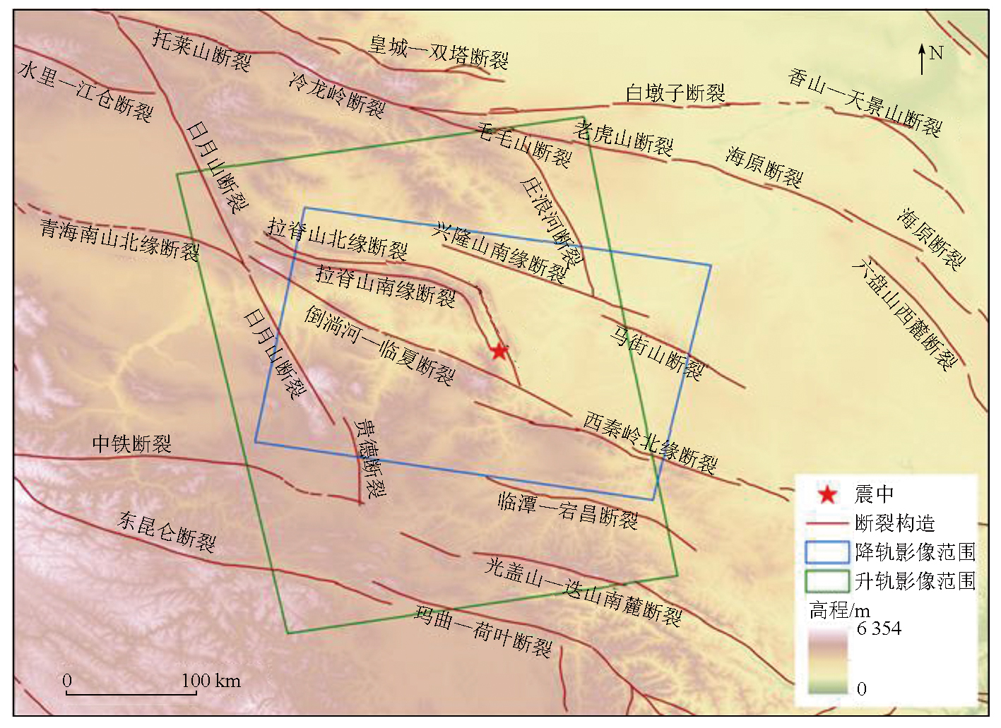
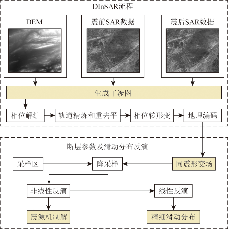
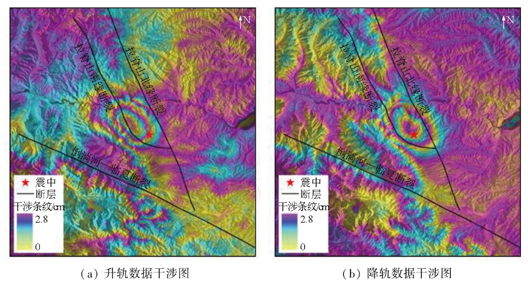
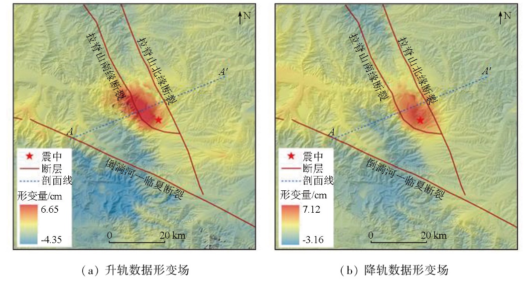
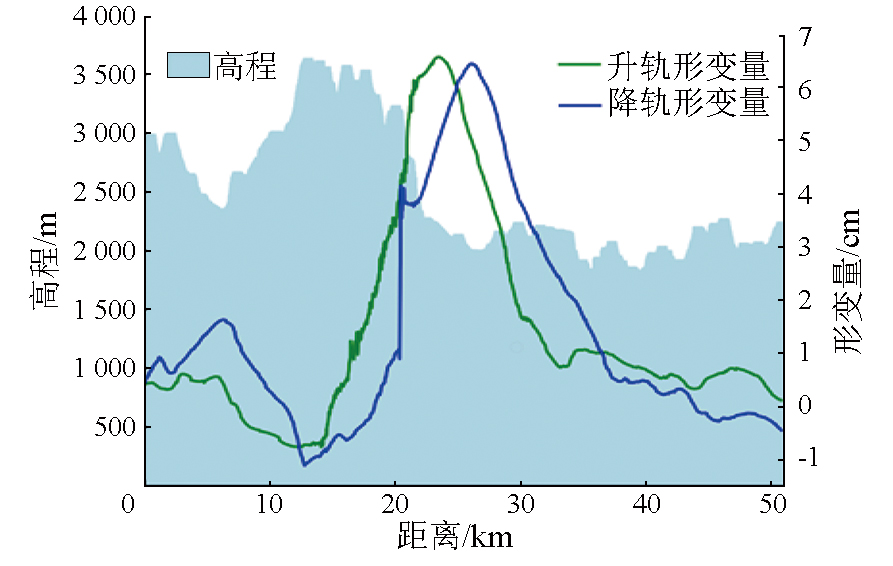
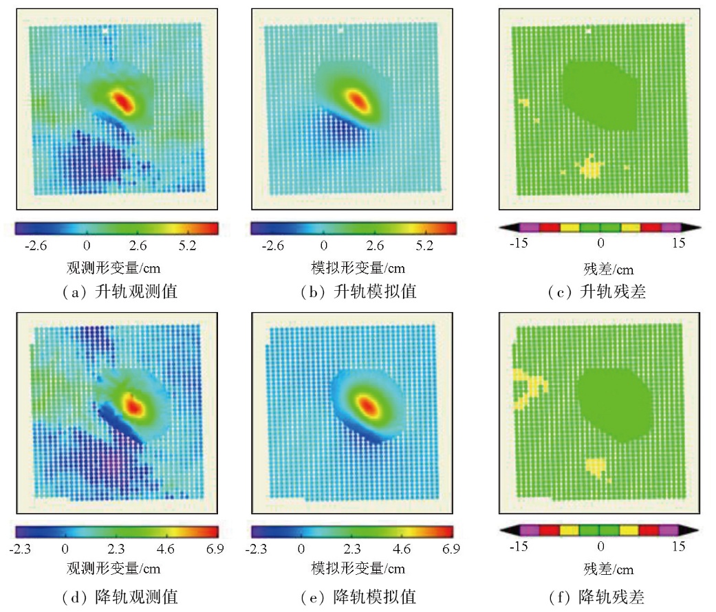
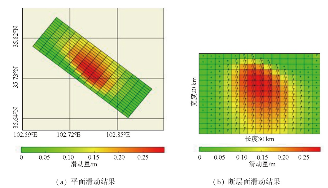
On December 18,2023,a M6.2 earthquake struck Jishishan Bonan,Dongxiang,and Salar Autonomous County,Gansu Province,China,with a maximum seismic intensity of VIII,causing severe environmental damage. This study aims to determine the basic parameters of the seismogenic fault and analyze its movement. To this end,this study,based on the two-pass differential interferometric synthetic aperture radar (D-InSAR) technique,obtained the coseismic deformation field of this earthquake using ascending and descending orbit from the Sentinel-1A satellite,as well as digital elevation model (DEM) data before and after the earthquake. Based on the dislocation theory in a homogeneous elastic half-space (the Okada dislocation model),a mapping model was established to link coseismic deformation and fault movement. The coseismic deformation field was used to fit the seismogenic fault,followed by the inversion for basic parameters of the seismogenic fault and the simulation of fault slip distribution. The results show that the maximum deformation from the ascending orbit data was about 6.65 cm,while that from the descending orbit data was about 7.12 cm. The seismogenic fault exhibited a strike of 308.14°,a dip angle of 61.57°,and a slip angle of 71.42°. Moreover,the fault presented a maximum slip of approximately 0.29 m located approximately 8 m below the surface and a moment magnitude of Mw6.17. The fault is characterized by thrust movement,with a minor left-lateral strike-slip movement. Based on the regional geological structure,the seismogenic fault is speculated to be the southern margin fault of Laji Mountain,with surface rupture caused by the earthquake.
徐雨帆, 李圣, 曹彦波, 胡瑞峰. 积石山M6.2级地震InSAR同震形变场及发震断层探讨[J]. 自然资源遥感, 2025, 37(5): 216-223.
XU Yufan, LI Sheng, CAO Yanbo, HU Ruifeng. InSAR-derived coseismic deformation field and seismogenic fault of the M6.2 Jishishan earthquake. Remote Sensing for Natural Resources, 2025, 37(5): 216-223.
Lu S M, Wu Z H, Li Z C. Seismic structure characteristics of the 18 December 2023 M6.2 Jishishan earthquake,Gansu Province[J]. Progress in Earthquake Sciences, 2024, 54(1):86-93.
Guo X Y, Han L B, Zhang X, et al. Source parameters and rupture characteristics of the M6.2 Jishishan earthquake in Gansu Province on December 18,2023[J]. Progress in Earthquake Sciences, 2024, 54(1):75-85.
Wang R Y, Wan Y G, Song Z Y, et al. Focal mechanism and stress implication on the surrounding region of the Jishishan,Gansu MS 6.2 earthquake on December 18,2023[J]. Earthquake, 2024, 44(1):175-184.
Yang Y M, Su S J. The 2023 Jishishan MS 6.2 earthquake in Gansu Province,China:A shallow strong earthquake with thrust-dominated components[J]. Earthquake,2024, 44(1):167-174.
Wang Q C, Luo J, Chen H L, et al. Focal mechanism for the December 18,2023,Jishishan MS 6.2 earthquake in Gansu Province[J]. Earthquake, 2024, 44(1):185-188.
Fang N, Sun K, Huang C C, et al. Joint inversion of InSAR and seismic data for the kinematic rupture process of the 2023 MS 6.2 Jishishan(Gansu,China) earthquake[J]. Geomatics and Information Science of Wuhan University, 2025, 50(2):333-343.
Yang J Y, Wen Y M, Xu C J. Seismogenic fault structure of the 2023 MS 6.2 Jishishan(Gansu,China)earthquake revealed by InSAR observations[J]. Geomatics and Information Science of Wuhan University, 2025, 50(2):313-321.
Zhang W T, Ji L Y, Chen Y X, et al. Analysis of crustal deformation of the 2023 MS 6.2 Jishishan earthquake in Gansu Province[J]. Geomatics and Information Science of Wuhan University, 2025, 50(2):391-403.
Li Y S, Li W L, Xu Q, et al. Coseismic deformation and slip distribution of the 2023 Jishishan MS 6.2 earthquake revealed by InSAR observations[J]. Journal of Chengdu University of Technology (Science & Technology Edition), 2024, 51(1):22-32,75.
Zhang J L, Xu Y R, Li W Q, et al. Analysis of the markers of seismic structures for moderate earthquakes:A case study of the 2023 Jishishan MS 6.2 earthquake[J]. Earthquake, 2024, 44(1):226-234.
[11]
Hirose H, Hirahara K, Kimata F, et al. A slow thrust slip event following the two 1996 Hyuganada Earthquakes beneath the Bungo Channel,southwest Japan[J]. Geophysical Research Letters, 1999, 26(21):3237-3240.
[12]
Jin Z, Fialko Y, Zubovich A, et al. Lithospheric deformation due to the 2015 M7.2 sarez (Pamir) earthquake constrained by 5 years of space geodetic observations[J]. Journal of Geophysical Research:Solid Earth, 2022, 127(4):e2021JB022461.
[13]
Jin Z, Fialko Y. Coseismic and early postseismic deformation due to the 2021 M7.4 Maduo (China) earthquake[J]. Geophysical Research Letters, 2021, 48(21):e2021GL095213.
[14]
Massonnet D, Rossi M, Carmona C, et al. The displacement field of the Landers earthquake mapped by radar interferometry[J]. Nature, 1993, 364(6433):138-142.
[15]
Zebker H A, Rosen P A, Goldstein R M, et al. On the derivation of coseismic displacement fields using differential radar interferometry:The Landers earthquake[J]. Journal of Geophysical Research:Solid Earth, 1994, 99(B10):19617-19634.
[16]
Lakhote A, Thakkar M G, Kandregula R S, et al. Estimation of active surface deformation in the eastern Kachchh region,western India:Application of multi-sensor DInSAR technique[J]. Quaternary International, 2021, 575:130-140.
[17]
Carboni F, Porreca M, Valerio E, et al. Surface ruptures and off-fault deformation of the October 2016 central Italy earthquakes from DInSAR data[J]. Scientific Reports, 2022, 12(1):3172.
doi: 10.1038/s41598-022-07068-9
pmid: 35210512
Qu C Y, Zuo R H, Shan X J, et al. Coseismic deformation field of the Nepal MS 8.1 earthquake from Sentinel-1A/InSAR data and fault slip inversion[J]. Chinese Journal of Geophysics, 2017, 60(1):151-162.
Wang S W, Ji L Y, Zhu L Y, et al. Co-seismic deformation field and fault slip distribution of the 2021 Maduo Mw 7.4 earthquake in Qinghai,China based on InSAR technology[J]. Journal of Earth Sciences and Environment, 2022, 44(6):1016-1026.
[20]
Qiu J, Ji L, Zhu L, et al. The June 2022 Khost earthquake in southeastern Afghanistan:A complicated shallow slip event revealed with InSAR[J]. Geodesy and Geodynamics, 2023, 14(6):559-565.
Liu Z J, Han B Q, Nai Y H. Source parameters and slip distribution of the 2023 Mw 6.0 Jishishan(Gansu,China) earthquake constrained by InSAR observations[J]. Geomatics and Information Science of Wuhan University, 2025, 50(2):344-355.
Chen P, Qiu L C, Yao Y B, et al. Surface deformation and hazard analysis after the 2023 MS 6.2 earthquake in Jishishan,Gansu Province based on InSAR and optical imagery interpretation[J]. Geomatics and Information Science of Wuhan University, 2025, 50(2):257-270.
[23]
王二七, 张旗, Clark B B. 青海拉鸡山:一个多阶段抬升的构造窗[J]. 地质科学, 2000, 35(4):493-500.
Wang E Q, Zhang Q, Burchfiel C. The lajishan fault belt in Qinghai Province:A multi-staged uplifting structural window[J]. Scientia Geologica Sinica, 2000, 35(4):493-500.
Yuan D Y, Zhang P Z, Lei Z S, et al. A preliminary study on the new activity features of the Lajishan Mountain fault zone in Qinghai Province[J]. Earthquake Research in China, 2005, 21(1):93-102.
Teng R Z, Jin Y Q, Li X H, et al. Recent activity characteristis of the fault zone at northern edge of western Qinling MT[J]. China Earthquake Engineering Journal, 1994, 16(2):85-90.
[26]
Tong X, Xu X, Chen S. Coseismic slip model of the 2021 Maduo earthquake,China from sentinel-1 InSAR observation[J]. Remote Sensing, 2022, 14(3):436.
Yuan D Y. Tectonic deformation features and space-time evolution in northeastern margin of the Qinghai-Tibetan Plateau since the late cenozoic time[D]. Beijing: Institute of Geology,Seismological Bureau of China, 2003.
 2025, Vol. 37
  ), 李圣1(