Please wait a minute...
 
国土资源遥感  2019, Vol. 31 Issue (1): 187-194    DOI: 10.6046/gtzyyg.2019.01.25
  技术应用 本期目录 | 过刊浏览 | 高级检索 |
基于InSAR技术天山乌吐劲河谷同震形变遥感研究
汪东1,2, 来风兵1,2(), 陈孟禹3, 陈蜀江1,2, 黄铁成1,2, 贾翔1,2
1.新疆师范大学地理科学与旅游学院,乌鲁木齐 830054
2.乌鲁木齐空间遥感应用研究所,乌鲁木齐 830025
3.苏州科技学院外国语学院,苏州 215009
Research on coseismic deformation in Ukraine River Valley of Tianshan Mountains based on InSAR technology
Dong WANG1,2, Fengbing LAI1,2(), Mengyu CHEN3, Shujiang CHEN1,2, Tiecheng HUANG1,2, Xiang JIA1,2
1.College of Geographical Science and Tourism, Xinjiang Normal University, Urumqi 830054,China
2.Urumqi Institute of Spatial Remote Sensing Applications, Urumqi 830025, China
3.School of Foreign Languages, Suzhou University of Science and Technology, Suzhou 215009, China
全文: PDF(3573 KB)   HTML  
输出: BibTeX | EndNote (RIS)      
摘要 

基于ALOS/PALSAR雷达卫星影像,采用合成孔径雷达干涉测量(interferometric synthetic aperture Radar,InSAR)技术,重建地震形变前后的数字高程模型(digital elevation model,DEM),经RTK校验后利用差值算法反演天山乌吐劲河谷地震同震场形变特征。研究结果表明: ①去尖三角状崩塌形变面积为104.47万m 2,崩塌量为1 461.60万m 3,起始端高程为3 225 m,平均坡度为48°,坡向为NNW; ②喇叭状堆积形变面积为78.61万m 2,堆积量为1 424.27万m 3,掩埋深度为3580 m; ③河道南岸堆积形变将河床向北推进了100 m、向东推进了300 m; ④崩塌形变阻塞河道后导致水体形变,形成堰塞湖水面面积在30 d内由原有的0.039 km 2增大至0.059 km 2,并在2010年湖面面积出现峰值0.146 km 2; ⑤形变原因不仅是由于其处在地震活动带上,还有石灰岩岩性、地形坡度和断裂构造等综合因素作用的结果。

服务
把本文推荐给朋友
加入引用管理器
E-mail Alert
RSS
作者相关文章
汪东
来风兵
陈孟禹
陈蜀江
黄铁成
贾翔
关键词 InSAR同震形变天山遥感堰塞湖    
Abstract

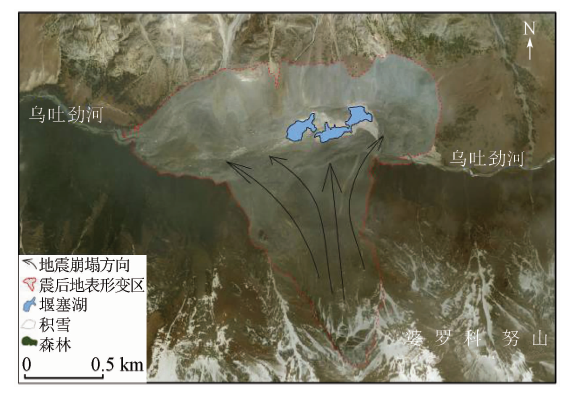
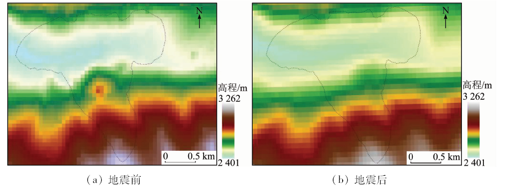
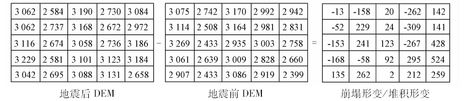
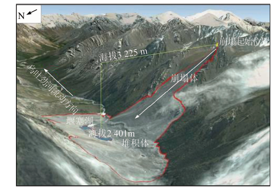
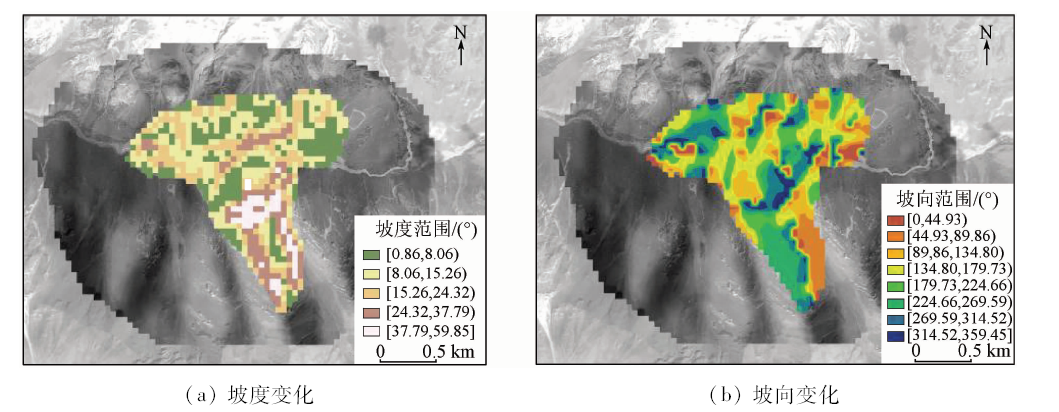
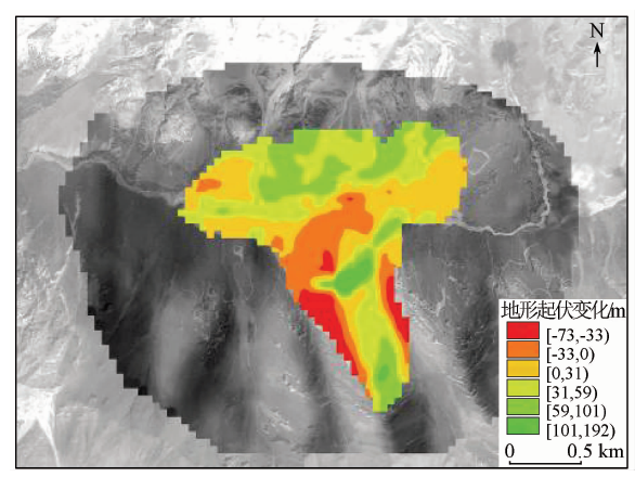
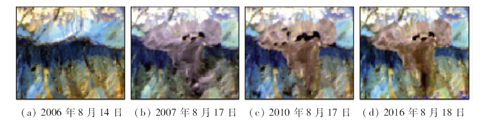
In this paper, the authors studied the coseismic deformation in Ukraine River valley in Tianshan Mountains, and reconstructed digital elevation modle (DEM) graph of 12.5 m spatial resolution for the study area before and after the earthquake using the ALOS / PALSAR data by InSAR remote sensing technique. Then the authors obtained the remote sensing characteristics of seismic collapse of earthquake by difference method of the DEM after the field verification by RTK calibration. The results show that: ①The area of the collapse of the triangle is 104.47 million m 2, the collapse is 1 416.60 million m 3, the starting elevation is 3 225 m, the average slope is 48°, and slope direction is NNW. ②The trumpet-shaped accumulation body area is 78.61 million m 2, the accumulation is 1 424.27 million m 3, and the buried depth is between 35 m and 80 m. ③The river bed was pushed northward by 100 m, and the eastward advance reached 300 m, due to the accumulation body of the south of the river channel. ④Collapse of the body led to the the formation of quake river. The surface area of the lake increased from 0.039 km 2 to 0.059 km 2 within 30 days and the lake area reached the peak of 0.146 km 2 in 2010. ⑤The factors responsible for the collapse included not only seismic activity but also limestone lithology, terrain slope, fault structure and other comprehensive factors.

Key wordsInSAR    coseismic deformation    Tianshan Mountains    remote sensing    dammed lake
收稿日期: 2017-07-26      出版日期: 2019-03-14
:  P316P694  
基金资助:国家自然科学基金项目"塔克拉玛干西部别里库姆沙漠胡扬沙堆发育模式及其在荒漠监测中的作用"(41661002);新疆干旱区湖泊环境与资源重点实验室开放基金项目" 塔克拉玛干西部别里库姆沙漠胡扬沙堆发育机制研究"(XJDX0909-2015-04)
通讯作者: 来风兵
作者简介: 汪东(1993-),男,硕士研究生,主要研究方向为资源环境遥感和空间信息提取。Email: wang_d1209@163.com。
引用本文:   
汪东, 来风兵, 陈孟禹, 陈蜀江, 黄铁成, 贾翔. 基于InSAR技术天山乌吐劲河谷同震形变遥感研究[J]. 国土资源遥感, 2019, 31(1): 187-194.
Dong WANG, Fengbing LAI, Mengyu CHEN, Shujiang CHEN, Tiecheng HUANG, Xiang JIA. Research on coseismic deformation in Ukraine River Valley of Tianshan Mountains based on InSAR technology. Remote Sensing for Land & Resources, 2019, 31(1): 187-194.
链接本文:  
https://www.gtzyyg.com/CN/10.6046/gtzyyg.2019.01.25      或      https://www.gtzyyg.com/CN/Y2019/V31/I1/187
Fig.1  研究区位置示意图
发震时刻 纬度/(°) 经度/(°) 震中距/km 深度/km 里氏震级(ML) 短周期体
波震级(mb)
台站数目 标准偏差
2007/07/03
15∶21∶09.1
44.49 N 83.37 E 38.14 10.0 5.7 5.9 10 2.93
Tab.1  中国地震台(CSN)地震目录(中国新疆北部)
台站 震中距/(°) 方位角/(°) 震相 到时 到时偏差/s 震级 周期/s 振幅/μm
WMQ 3.2 101.0 Pn 15: 22: 01.0 1.4
WMQ 3.2 101.0 Sg 15: 22: 50.0 1.0
WMQ 3.2 101.0 SMN 5.7 0.5 0.260 00
WMQ 3.2 101.0 SME 5.7 0.5 0.250 00
Tab.2  中国地震台(CSN)地震震相报告(中国新疆北部)
Fig.2  InSAR获取DEM的处理流程
Fig.3  地震前后InSAR重建的DEM
Fig.4  DEM精度校验结果
Fig.5  崩塌形变/堆积形变格网示意图
Fig.6  崩塌形变与堆积形变示意图
Fig.7  研究区地震后坡度、坡向变化
Fig.8  研究区震后地形起伏变化
Fig.9  2006—2016年间Landsat卫星监测乌吐劲堰塞湖湖面变化
监测时间 湖面面积/m2 湖面高程/m
2006年8月14日 39 000 2 402.904
2007年8月1日 59 000 2 406.829
2007年8月17日 88 900 2 409.031
2007年9月18日 53 000 2 405.716
2008年7月26日 89 400 2 410.874
2009年6月19日 48 400 2 404.441
2010年8月17日 146 000 2 420.724
2011年7月12日 78 400 2 408.927
2013年8月9日 94 300 2 411.030
2014年8月21日 91 050 2 410.951
2015年7月6日 89 400 2 410.706
2016年8月18日 97 200 2 411.125
Tab.3  2006—2016年间乌吐劲堰塞湖面积及高程变化
[1] 章鑫, 杜学彬, 王丽 , 等. 南北地震带大地电流分布与地震活动关系探讨[J]. 地学前缘, 2017,24(2):202-211.
doi: 10.13745/j.esf.2017.02.019
Zhang X, Du X B, Wang L , et al. The spatial distribution of telluric currents and its relationship with earthquake activities in North-South Seismic Belt[J]. Earth Science Frontiers, 2017,24(2):202-211.
[2] 张钰, 陈晓清, 游勇 , 等. 汶川地震后肖家沟泥石流活动特征与灾害防治[J]. 水土保持通报, 2014,34(5):284-289.
Zhang Y, Chen X Q, You Y , et al. Activity characteristics and disaster control of Xiaojia Gully debris flow after Wenchuan earthquake[J]. Bulletin of Soil and Water Conservation, 2014,34(5):284-289.
[3] 石振明, 郑鸿超, 彭铭 , 等. 考虑不同泄流槽方案的堰塞坝溃决机理分析——以唐家山堰塞坝为例[J]. 工程地质学报, 2016,24(5):741-751.
doi: 10.13544/j.cnki.jeg.2016.05.003
Shi Z M, Zheng H C, Peng M , et al. Breaching mechanism analysis of landslide dams considering different spillway schemes:A case study of Tangjiashan landslide dam[J]. Journal of Engineering Geo-logy, 2016,24(5):741-751.
[4] 陈丹蕾, 刘国祥, 王晓文 , 等. 基于DInSAR技术与断层自动剖分方法反演断层滑动参数[J]. 国土资源遥感, 2016,28(3):25-0.doi: 10.6046.gtzyyg.2016.03.05.
doi: 10.6046/gtzyyg.2016.03.05
Chen D L, Liu G X, Wang X W , et al. Inversion of fault slip parameters based on DInSAR and automated fault model discretization method[J]. Remote Sensing for Land and Resources, 2016,28(3):25-30.doi: 10.6046.gtzyyg.2016.03.05.
[5] O’Connor J E, Costa J E . The World’s Largest Floods,Past and Present:Their Causes and Magnitudes[M]. U.S.Geological Survey, 2004: 1-13.
[6] Montgomery D R, Hallet B, Liu Y P , et al. Evidence for Holocene mega floods down the Tsangpo River gorge,Southeastern Tibet[J]. Quaternary Research, 2004,62(2):201-207.
doi: 10.1016/j.yqres.2004.06.008
[7] 赵峰 . 多平台时序InSAR技术的地表形变联合监测方法研究[D]. 徐州:中国矿业大学, 2016.
Zhao F . Study on the Method of Multi-platform SAR Data Sets and MTInSAR Technique Based Ground Deformation Monitoring[D]. Xuzhou:China University of Mining and Technology, 2016.
[8] 雍琦 . InSAR和GPS大地测量形变数据反演地震断层滑动的影响特征研究[D]. 成都:西南交通大学, 2017.
Yong Q . Research on Characteristics of Inversion for Earthquake Fault Slip Constrained by InSAR and GPS Geodetic Deformation Data[D]. Chengdu:Southwest Jiaotong University, 2017.
[9] Mckillop R J, Clague J J . Statistical remote sensing-based appro-ach for estimating the probability of catastrophic drainage from moraine-dammed lakes in southwestern British Columbia[J]. Global and Planetary Change, 2007,56(1-2):153-171.
doi: 10.1016/j.gloplacha.2006.07.004
[10] 王治华, 徐起德 . 西藏帕里湖卫星遥感监测[J]. 山地学报, 2009,27(2):240-247.
doi: 10.3969/j.issn.1008-2786.2009.02.015
Wang Z H, Xu Q D . Satellite remote sensing monitoring for Pali Lake of Tibet,China[J]. Mountain Research, 2009,27(2):240-247.
[11] 范建容, 田兵伟, 程根伟 , 等. 基于多源遥感数据的5·12汶川地震诱发堰塞体信息提取[J]. 山地学报, 2008,26(3):257-262.
doi: 10.3969/j.issn.1008-2786.2008.03.001
Fan J R, Tian B W, Cheng G W , et al. Investigation on damming object induced by the earthquake of Wenchuan on May 12 based on multi-platform remote sensing[J]. Mountain Research, 2008,26(3):257-262.
[12] 殷幼松 . 高相干分布式目标应用于时间序列InSAR技术监测地表形变研究[D]. 北京:中国测绘科学研究院, 2016.
Yin Y S . Highly-coherence Distributed Scatterer Time-series InSAR and Its Application to Monitoring Ground Deformation[D]. Beijing:Chinese Academy of Surveying and Mapping, 2016.
[13] 高明亮, 宫辉力, 陈蓓蓓 , 等. 基于InSAR技术的地表三维形变获取方法综述[J]. 测绘通报, 2017(1):1-4.
doi: 10.13474/j.cnki.11-2246.2017.0001
Gao M L, Gong H L, Chen B B , et al. Review of three-dimensional surface deformation acquisition from InSAR measurements and its application[J].Bulletin of Surveying and Mapping, 2017(1):1-4.
[14] 刘振国 . DInSAR技术在矿区地表重复采动开采沉陷监测中的应用研究[D]. 徐州:中国矿业大学, 2014.
Liu Z G . Study on the Subsidence Monitoring Caused by Repeated Excavation with DInSAR Technology[D]. Xuzhou:China University of Mining and Technology, 2014.
[15] 占文俊, 李志伟, 韦建超 , 等. 一种InSAR大气相位建模与估计方法[J]. 地球物理学报, 2015,58(7):2320-2329.
doi: 10.6038/cjg20150710
Zhan W J, Li Z W, Wei J C , et al. A strategy for modeling and estimating atmospheric phase of SAR[J]. Chinese Journal of Geophysics, 2015,58(7):2320-2329.
[16] 罗菲 . 查干莫顿水电站调水流量分析[J]. 小水电, 2017(1):34-36.
doi: 10.3969/j.issn.1007-7642.2017.01.012
Luo F . Analysis on water diversion flow of Chagan Morton hydropower station[J]. Small Hydro Power, 2017(1):34-36.
[17] 张悼元, 王士天 .滑坡文集(8)[C]// 滑坡文集编委会. 滑坡文集. 北京: 中国铁道出版社, 1982: 92-95.
Zhang D Y, Wang S T. Landslide articles editorial board (8)[C]// Landslide articles editorial board. Landslide artides. Beijing: China Railway Publishing House, 1982: 92-95.
[18] 周廷儒 . 新疆地貌[M]. 北京: 科学出版社, 1978.
Zhou T R. Xinjiang Geomorphology[M]. Beijing: Science Press, 1978.
[1] 李伟光, 侯美亭. 植被遥感时间序列数据重建方法简述及示例分析[J]. 自然资源遥感, 2022, 34(1): 1-9.
[2] 丁波, 李伟, 胡克. 基于同期光学与微波遥感的茅尾海及其入海口水体悬浮物反演[J]. 自然资源遥感, 2022, 34(1): 10-17.
[3] 高琪, 王玉珍, 冯春晖, 马自强, 柳维扬, 彭杰, 季彦桢. 基于改进型光谱指数的荒漠土壤水分遥感反演[J]. 自然资源遥感, 2022, 34(1): 142-150.
[4] 杨旺, 何毅, 张立峰, 王文辉, 陈有东, 陈毅. 甘肃金川矿区地表三维形变InSAR监测[J]. 自然资源遥感, 2022, 34(1): 177-188.
[5] 张秦瑞, 赵良军, 林国军, 万虹麟. 改进遥感生态指数的宜宾市三江汇合区生态环境评价[J]. 自然资源遥感, 2022, 34(1): 230-237.
[6] 贺鹏, 童立强, 郭兆成, 涂杰楠, 王根厚. 基于地形起伏度的冰湖溃决隐患研究——以希夏邦马峰东部为例[J]. 自然资源遥感, 2022, 34(1): 257-264.
[7] 刘文, 王猛, 宋班, 余天彬, 黄细超, 江煜, 孙渝江. 基于光学遥感技术的冰崩隐患遥感调查及链式结构研究——以西藏自治区藏东南地区为例[J]. 自然资源遥感, 2022, 34(1): 265-276.
[8] 王茜, 任广利. 高光谱遥感异常信息在阿尔金索拉克地区铜金矿找矿工作中的应用[J]. 自然资源遥感, 2022, 34(1): 277-285.
[9] 吕品, 熊丽媛, 徐争强, 周学铖. 基于FME的矿山遥感监测矢量数据图属一致性检查方法[J]. 自然资源遥感, 2022, 34(1): 293-298.
[10] 张大明, 张学勇, 李璐, 刘华勇. 一种超像素上Parzen窗密度估计的遥感图像分割方法[J]. 自然资源遥感, 2022, 34(1): 53-60.
[11] 薛白, 王懿哲, 刘书含, 岳明宇, 王艺颖, 赵世湖. 基于孪生注意力网络的高分辨率遥感影像变化检测[J]. 自然资源遥感, 2022, 34(1): 61-66.
[12] 宋仁波, 朱瑜馨, 郭仁杰, 赵鹏飞, 赵珂馨, 朱洁, 陈颖. 基于多源数据集成的城市建筑物三维建模方法[J]. 自然资源遥感, 2022, 34(1): 93-105.
[13] 艾璐, 孙淑怡, 李书光, 马红章. 光学与SAR遥感协同反演土壤水分研究进展[J]. 自然资源遥感, 2021, 33(4): 10-18.
[14] 李特雅, 宋妍, 于新莉, 周圆锈. 卫星热红外温度反演钢铁企业炼钢月产量估算模型[J]. 自然资源遥感, 2021, 33(4): 121-129.
[15] 刘白露, 管磊. 南海珊瑚礁白化遥感热应力检测改进方法研究[J]. 自然资源遥感, 2021, 33(4): 136-142.
Viewed
Full text


Abstract

Cited

  Shared   
  Discussed   
京ICP备05055290号-2
版权所有 © 2015 《自然资源遥感》编辑部
地址:北京学院路31号中国国土资源航空物探遥感中心 邮编:100083
电话:010-62060291/62060292 E-mail:zrzyyg@163.com
本系统由北京玛格泰克科技发展有限公司设计开发