Please wait a minute...
 
国土资源遥感  2018, Vol. 30 Issue (3): 113-119    DOI: 10.6046/gtzyyg.2018.03.16
     本期目录 | 过刊浏览 | 高级检索 |
农村居民点空间布局及优化分析——以重庆市合川区狮滩镇聂家村为例
曾远文, 丁忆, 胡艳, 陈静, 段松江
重庆市地理信息中心,重庆 401121
An analysis of spatial distribution and optimization of rural settlements:A case study of Niejia Village in Shitan Town,Hechuan District,Chongqing
Yuanwen ZENG, Yi DI, Yan HU, Jing CHEN, Songjiang DUAN
Chongqing Geomatics Center, Chongqing 401121
全文: PDF(3534 KB)   HTML  
输出: BibTeX | EndNote (RIS)      
摘要 

农村居民点空间布局的优化是土地利用总体规划的重要内容,对统筹城乡发展具有重要意义。运用空间分析技术和景观指数方法,以合川区狮滩镇聂家村为研究对象,对村域内农村居民点分布特征及其影响因素进行了分析,并在ArcGIS平台下,进行定量与定性分析,确定农村居民点适宜区域,并进一步优化其空间格局。该研究可为新农村建设、村规划及土地利用总体规划农村居民点优化选址提供参考和借鉴。

服务
把本文推荐给朋友
加入引用管理器
E-mail Alert
RSS
作者相关文章
曾远文
丁忆
胡艳
陈静
段松江
关键词 农村居民点空间分析景观指数空间布局优化    
Abstract

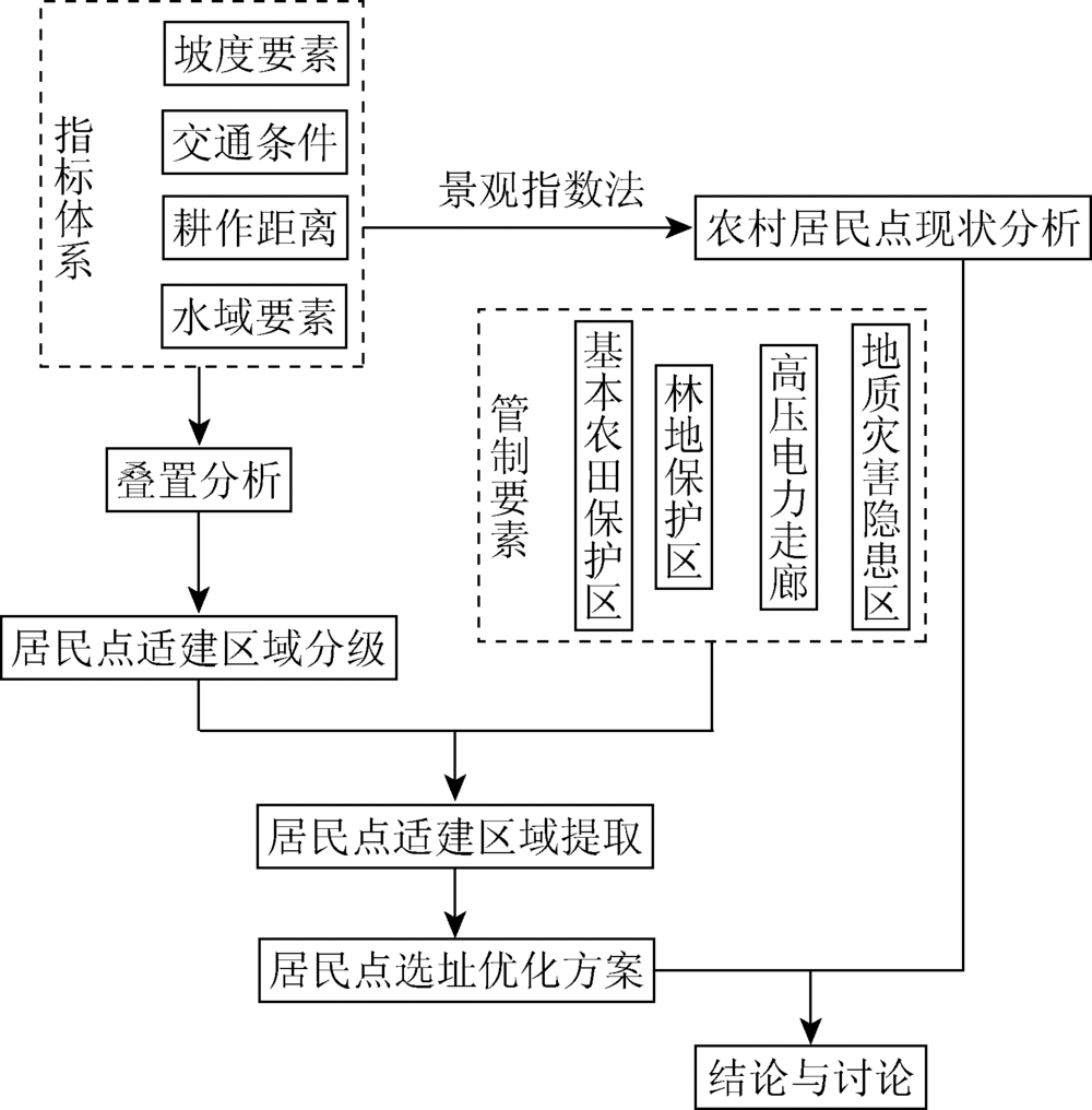
The spatial distribution optimization of rural settlement, as one of the most important contents of Overall Planning of Land Use, plays an important role in the coordination and balance of urban and rural development. Based on the spatial analysis technique and landscape ecology theory, the authors studied the distribution characteristics and influencing factors of rural settlements in village regions with Niejia Village of Shitan County as a study case. ArcGIS was employed in this study to carry out quantitative and qualitative analysis so as to select the best location of the rural settlement layout in this village. The results can provide a reference for the new rural construction, village planning, and rural settlement optimal location selection of the general land use planning.

Key wordsrural settlement    spatial analysis    landscape index    spatial distribution optimization
收稿日期: 2017-01-13      出版日期: 2018-09-10
:  TP79  
基金资助:地理空间信息工程国家测绘地理信息局重点实验室经费资助项目“基于高分影像和基础地理信息的违法建筑动态监测研究”(201304)
作者简介: 曾远文(1989-),男,硕士研究生,工程师,主要研究领域为城乡规划。Email: zyw@dl023.net。
引用本文:   
曾远文, 丁忆, 胡艳, 陈静, 段松江. 农村居民点空间布局及优化分析——以重庆市合川区狮滩镇聂家村为例[J]. 国土资源遥感, 2018, 30(3): 113-119.
Yuanwen ZENG, Yi DI, Yan HU, Jing CHEN, Songjiang DUAN. An analysis of spatial distribution and optimization of rural settlements:A case study of Niejia Village in Shitan Town,Hechuan District,Chongqing. Remote Sensing for Land & Resources, 2018, 30(3): 113-119.
链接本文:  
https://www.gtzyyg.com/CN/10.6046/gtzyyg.2018.03.16      或      https://www.gtzyyg.com/CN/Y2018/V30/I3/113
Fig.1  研究区示意图
Fig.2  技术路线
指数 A/hm2 n/个 Ai/hm2 Di Si Fi
数值 722.07 141 35.42 0.220 9 0.049 1 4.5
Tab.1  村域居民点景观指数分析
Fig.3  不同坡度等级居民点的分布
等级 A/hm2 n/个 Ai/hm2 Di Si Fi
108.47 36 7.33 0.288 1 0.067 6 4.26
41.46 19 3.53 0.338 5 0.085 0 3.98
139.38 57 12 0.319 7 0.086 1 3.71
214.31 19 8.3 0.148 9 0.038 7 3.84
Tab.2  不同坡度等级居民点景观指数分析
Fig.4  不同道路缓冲区等级居民点的分布
等级 A/hm2 n/个 Ai/hm2 Di Si Fi
225.35 87 19.73 0.310 7 0.087 5 3.55
176.79 25 6.78 0.188 0 0.038 3 4.91
128.72 15 2.77 0.170 7 0.021 5 7.94
84.55 3 1.80 0.094 2 0.021 3 4.42
Tab.3  不同道路缓冲区等级居民点景观指数分析
Fig.5  不同耕作距离缓冲区等级居民点的分布
等级 A/hm2 n/个 Ai/hm2 Di Si Fi
199.29 141 35.42 0.420 6 0.177 7 2.37
61.88 0 0
38.17 0 0
15.77 0 0
Tab.4  不同耕作距离缓冲区等级居民点景观指数分析
Fig.6  不同水域缓冲区等级居民点的分布
等级 A/hm2 n/个 Ai/hm2 Di Si Fi
239.94 70 19.01 0.270 1 0.079 2 3.41
205.21 40 10.19 0.220 7 0.049 6 4.45
121.32 26 5.27 0.231 5 0.043 4 5.33
45.56 3 0.95 0.128 3 0.020 9 6.14
Tab.5  不同水域缓冲区等级居民点景观指数分析
Fig.7  研究区主要管制要素图
Fig.8  农村居民点适建等级图
等级 A/hm2 n/个 Ai/hm2 Di Si Fi
38.85 85 18.50 0.739 6 0.476 2 1.55
56.81 34 7.48 0.386 8 0.131 6 2.94
66.40 9 3.59 0.184 1 0.054 0 3.41
10.32 0 0
Tab.6  不同适建等级居民点景观指数分析
Fig.9  农村居民点空间布局优化结果
[1] 孙华生, 黄敬峰, 金艳 , 等. 基于GIS技术的县域居民点空间分布特征分析及其优化布局[J]. 浙江大学学报(农业与生命科学版), 2007,33(3):348-354.
Sun H S, Huang J F, Jin Y , et al. Spatial distribution characteristics analysis and optimization of county-level settlements based on GIS[J]. Journal of Zhejiang University(Agriculture & Life Sciences), 2007,33(3):348-354.
[2] 张小林 . 乡村概念辨析[J]. 地理学报, 1998,53(4):365-371.
Zhang X L . On discrimination of rural definitions[J]. Acta Geographica Sinica, 1998,53(4):365-371.
[3] 朱彬, 马晓冬 . 苏北地区乡村聚落的格局特征与类型划分[J]. 人文地理, 2011,26(4):66-72.
Zhu B, Ma X D . A research on pattern characteristics and type classification of rural settlement in northern Jiangsu Province[J]. Human Geography, 2011,26(4):66-72.
[4] 陈玉福, 孙虎, 刘彦随 . 中国典型农区空心村综合整治模式[J]. 地理学报, 2010,65(6):727-735.
Chen Y F, Sun H, Liu Y S . Reconstruction models of hollowed villages in key agricultural regions of China[J]. Acta Geographica Sinica, 2010,65(6):727-735.
[5] 宋伟, 陈百明, 张英 . 中国村庄宅基地空心化评价及其影响因素[J]. 地理研究, 2013,32(1):20-28.
Song W, Chen B M, Zhang Y . Typical survey and analysis on influencing factors of village-hollowing of rural housing land in China[J]. Geographical Research, 2013,32(1):20-28.
[6] 杨忍, 刘彦随, 陈秧分 . 中国农村空心化综合测度与分区[J]. 地理研究, 2012,31(9):1697-1706.
doi: 10.11821/yj2012090015
Yang R, Liu Y S, Chen Y F . Comprehensive measure and partition of rural hollowing in China[J]. Geographical Research, 2012,31(9):1697-1706.
[7] 曲衍波, 姜广辉, 张凤荣 , 等. 基于农户意愿的农村居民点整治模式[J]. 农业工程学报, 2012,28(23):232-242.
Qu Y B, Jiang G H, Zhang F R , et al. Models of rural residential land consolidation based on rural households’ willingness[J]. Transactions of the Chinese Society of Agricultural Engineering, 2012,28(23):232-242.
[8] 马晓冬, 李全林, 沈一 . 江苏省乡村聚落的形态分异及地域类型[J]. 地理学报, 2012,67(4):516-525.
Ma X D, Li Q L, Shen Y . Morphological difference and regional types of rural settlements in Jiangsu province[J]. Acta Geographica Sinica, 2012,67(4):516-525.
[9] 肖飞, 杜耘, 凌峰 , 等. 江汉平原村落空间分布与微地形结构关系探讨[J]. 地理研究, 2012,31(10):1786-1792.
doi: 10.11821/yj2012100005
Xiao F, Du Y, Ling F , et al. Spatial pattern of villages in Jianghan Plain and its relationships with the micro-topography[J]. Geographical Research, 2012,31(10):1786-1792.
[10] 沈陈华 . 丹阳市农村居民点空间分布尺度特征及影响因素分析[J]. 农业工程学报, 2012,28(22):261-268.
doi: 10.3969/j.issn.1002-6819.2012.22.036
Shen C H . Spatial distribution scale characteristics of rural settlements and analysis on influencing factors in Danyang City[J]. Transactions of the Chinese Society of Agricultural Engineering, 2012,28(22):261-268.
[11] 秦天天, 齐伟, 李云强 , 等. 基于生态位的山地农村居民点适宜度评价[J]. 生态学报, 2012,32(16):5175-5183.
doi: 10.5846/stxb201112141909
Qin T T, Qi W, Li Y Q , et al. Suitability evaluation of rural residential land based on niche theory in mountainous area[J]. Acta Ecologica Sinica, 2012,32(16):5175-5183.
[12] 房艳刚, 梅林, 刘继生 , 等. 近30年冀鲁豫农业村落民宅景观演化过程与机理[J]. 地理研究, 2012,31(2):220-233.
Fang Y G, Mei L, Liu J S , et al. Vernacular dwellings evolution in agricultural villages of Hebei-Shandong-Henan provinces in the past 30 years[J]. Geographical Research, 2012,31(2):220-233.
[13] 张娟锋, 任超群, 刘洪玉 , 等. 基于四维驱动力的农村居民点整理模式分析——以北京市通州区为例[J]. 地理研究, 2012,31(10):1815-1824.
doi: 10.11821/yj2012100008
Zhang J F, Ren C Q, Liu H Y , et al. Analysis of the land consolidation’s models of rural residential areas based on 4-D dynamics:A case study of Tongzhou District in Beijing[J]. Geographical Research, 2012,31(10):1815-1824.
[14] 海贝贝, 李小建, 许家伟 . 巩义市农村居民点空间格局演变及其影响因素[J]. 地理研究, 2013,32(12):2257-2269.
doi: 10.11821/dlyj201312008
Hai B B, Li X J, Xu J W . Spatio-temporal evolution of rural settlements in Gongyi[J]. Geographical Research, 2013,32(12):2257-2269.
[15] 谢保鹏, 朱道林, 陈英 , 等. 基于区位条件分析的农村居民点整理模式选择[J]. 农业工程学报, 2014,30(1):219-227.
Xie B P, Zhu D L, Chen Y , et al. Mode selection for rural residential land consolidation based on analysis of location condition[J]. Transactions of the Chinese Society of Agricultural Engineering, 2014,30(1):219-227.
[16] 杨立, 郝晋珉, 王绍磊 , 等. 基于空间相互作用的农村居民点用地空间结构优化[J]. 农业工程学报, 2011,27(10):308-315.
Yang L, Hao J M, Wang S L , et al. Spatial structure optimization of rural residential land based on spatial interaction[J]. Transactions of the Chinese Society of Agricultural Engineering, 2011,27(10):308-315.
[17] 朱雪欣, 王红梅, 袁秀杰 , 等. 基于GIS的农村居民点区位评价与空间格局优化[J]. 农业工程学报, 2010,26(6):326-333.
Zhu X X, Wang H M, Yuan X J , et al. Evaluation and optimization of spatial distribution of rural settlements based on GIS[J]. Transactions of the Chinese Society of Agricultural Engineering, 2010,26(6):326-333.
[18] 闵婕, 杨庆媛, 唐璇 . 三峡库区农村居民点空间格局演变——以库区重要区万州为例[J]. 经济地理, 2016,36(2):149-158.
Min J, Yang Q Y, Tang X . Spatial pattern evolution of rural settlement in the three gorges reservoir area:A case in Wanzhou County[J]. Economic Geography, 2016,36(2):149-158.
[19] 李君, 李小建 . 国内外农村居民点区位研究评述[J]. 人文地理, 2008,23(4):23-27.
Li J, Li X J . A review on location of the rural settlement[J]. Human Geography, 2008,23(4):23-27.
[20] Hill M . Rural Settlement and the Urban Impact on the Countryside[M]. London:Hodder & Stoughton, 2003: 20-36.
[21] Thorsen I, Ubøe J . Modeling residential location choice in an area with spatial barriers[J]. Regional Society, 2002,36(6):13-64.
doi: 10.1007/s001680200094
[22] 陈利顶, 傅伯杰 . 黄河三角洲地区人类活动对景观结构的影响分析——以山东省东营市为例[J]. 生态学报, 1996,16(4):337-344.
Chen L D, Fu B J . Analysis of impact of human activity on landscape structure in yellow river delta:A case study of Dongying region[J]. Acta Ecologica Sinica, 1996,16(4):337-344.
[23] 潘娟, 邱道持, 尹娟 . 基于农户意愿的农村居民点宜居性调查研究——以重庆潼南县桂林街道八角村为例[J]. 中国农学通报, 2011,27(23):189-192.
Pan J, Qiu D C, Yin J . Investigation of livability of rural residential areas based on households’ willingness:A case study of Bajiao village,Guilin town,Tongnan country,Chongqing city[J]. Chinese Agricultural Science Bulletin, 2011,27(23):189-192.
[1] 李东, 唐诚, 邹涛, 侯西勇. 近海人工鱼礁水下物理状态探测与评估[J]. 自然资源遥感, 2022, 34(1): 27-33.
[2] 宋仁波, 朱瑜馨, 丁上珊, 贺巧宁, 王细元, 王月香. 基于GIS空间分析的任意多边形骨架线自动提取方法[J]. 国土资源遥感, 2020, 32(1): 51-59.
[3] 张珂, 刘建忠, 程维明. 月球哥白尼纪次级坑的形态特征及其空间分布[J]. 国土资源遥感, 2019, 31(1): 255-263.
[4] 张晓萍, 吕颖, 张华国, 李朝奎. 1990―2011年舟山群岛不透水面动态遥感分析[J]. 国土资源遥感, 2018, 30(2): 178-185.
[5] 郭丽琴, 赵志芳, 代启学, 梁明月, 付义勋, 陈百炼. 基于RS和GIS文山州石漠化时空演变特征及成因研究[J]. 国土资源遥感, 2017, 29(s1): 106-113.
[6] 程滔. 大数据时代遥感数据管理与服务模式探索[J]. 国土资源遥感, 2016, 28(4): 202-206.
[7] 邹亚锋, 吕昌河, 白臻昊, 王海英. 不同整治模式下的农村居民点整治潜力测算[J]. 国土资源遥感, 2016, 28(4): 191-196.
[8] 杨娅楠, 王金亮, 陈光杰, 习晓环, 王成. 抚仙湖流域土地利用格局与水质变化关系[J]. 国土资源遥感, 2016, 28(1): 159-165.
[9] 陈应跃, 甘淑, 田禹东, 周曦冰. 山区土地评价的GIS空间分析建模研究[J]. 国土资源遥感, 2015, 27(2): 196-200.
[10] 李学渊, 赵博, 陈时磊, 赵颖旺, 边凯. 基于遥感与GIS的矿山地质环境时空演变分析——以东胜矿区为例[J]. 国土资源遥感, 2015, 27(2): 167-173.
[11] 李新萍, 郝多虎, 段朋. 右江谷地景观格局空间分异特性遥感研究[J]. 国土资源遥感, 2011, 23(3): 95-99.
[12] 李伟峰, 王轶. 基于目标分割和景观格局特征的城市土地利用分类[J]. 国土资源遥感, 2011, 23(1): 118-122.
[13] 朱刚, 高会军, 曾光, 金谋顺. 西北内陆干旱区河流绿色走廊湿地景观格局变化及其生态效应研究—以车尔臣河下游为例[J]. 国土资源遥感, 2010, 22(s1): 219-223.
[14] 刘芳, 张增祥, 赵晓丽, 胡顺光. 山东省农村居民点用地的时空变化特征及聚类分析[J]. 国土资源遥感, 2010, 22(3): 101-107.
[15] 姬翠翠, 李晓松, 曾源, 闫娜娜, 武文波, 吴炳方.
基于遥感和GIS的宣化县水土流失定量空间特征分析
[J]. 国土资源遥感, 2010, 22(2): 107-112.
Viewed
Full text


Abstract

Cited

  Shared   
  Discussed   
京ICP备05055290号-2
版权所有 © 2015 《自然资源遥感》编辑部
地址:北京学院路31号中国国土资源航空物探遥感中心 邮编:100083
电话:010-62060291/62060292 E-mail:zrzyyg@163.com
本系统由北京玛格泰克科技发展有限公司设计开发