Rapid monitoring of surface water based on remote sensing data and DeepLabv3+ model
KANG Hui1,2(), DOU Wenzhang1,3, HAN Lingyi4(), DING Ziyue4, WU Liangting4, HOU Lu5
1. School of Software and Microelectronics, Peking University,Beijing 102600, China 2. China Mobile Group Beijing Company Limited, Beijing 100007, China 3. Peking University Institute for Strategy Studies, Beijing 100091,China 4. China Areo Geophysical Survey and Remote Sensing Center for Natural Resources, Beijing 100083, China 5. School of Information and Engineering,Beijing University of Posts and Telecommunications, Beijing 100876, China
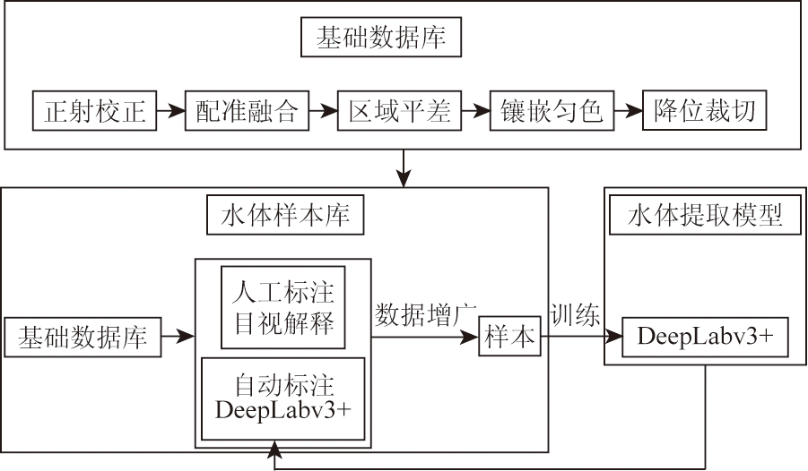
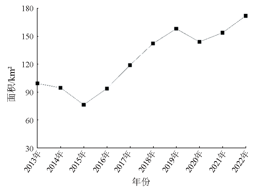
Surface water monitoring can provide important references for water resource protection. Using 2013-2022 remote sensing images from the domestic high-resolution GF-1 constellation, this study developed a pixel-scale method for surface water information extraction based on the DeepLabv3+deep learning model. The experimental results of derived in Miyun District of Beijing indicate that the proposed method can quickly obtain multiple phases of pixel-scale spatiotemporal distributions of surface water, with the extraction results roughly consistent with actual spatial distribution. Compared to conventional classification algorithms such as random forest, support vector machine, and maximum likelihood, this method exhibited extraction precision and recall of 99.22% and 98.01%, respectively, demonstrating high accuracy in water information extraction. The long-term serial monitoring results indicate that the surface water area evolved from a continuous decrease to an increase and then to stabilization from 2013 to 2022. Since the extraction accuracy and efficiency can meet the demand for the monitoring of the spatial changes in regional water bodies, the proposed method enjoys broad prospects for practical application in the fields of remote sensing-based rapid monitoring and ecological assessment of regional surface water resources.
康辉, 窦文章, 韩灵怡, 丁梓越, 吴亮廷, 侯璐. 基于DeepLabv3+模型的地表水体快速遥感监测[J]. 自然资源遥感, 2024, 36(4): 117-123.
KANG Hui, DOU Wenzhang, HAN Lingyi, DING Ziyue, WU Liangting, HOU Lu. Rapid monitoring of surface water based on remote sensing data and DeepLabv3+ model. Remote Sensing for Natural Resources, 2024, 36(4): 117-123.
Su L F, Li Z X, Gao F, et al. A review of remote sensing image water extraction[J]. Remote Sensing for Land and Resources, 2021, 33(1):9-19.doi:10.6046/gtzyyg.2020170.
[2]
Chen C, Liang J, Xie F, et al. Temporal and spatial variation of coastline using remote sensing images for Zhoushan Archipelago,China[J]. International Journal of Applied Earth Observation and Geoinformation, 2022, 107:102711.
[3]
McFeeters S K. The use of the normalized difference water index (NDWI) in the delineation of open water features[J]. International Journal of Remote Sensing, 1996, 17(7):1425-1432.
Wei C, Fu B L, Qin J L, et al. Monitoring of spatial-temporal dynamic changes in water surface in marshes based on multi-temporal Sentinel-1A data[J]. Remote Sensing for Natural Resources, 2022, 34(2):251-260.doi:10.6046/zrzyyg.2021205.
Dong S Y, Xue X, You Q G, et al. Remote sensing monitoring of the lake area changes in the Qinghai-Tibet Plateau in recent 40 years[J]. Journal of Lake Sciences, 2014, 26(4):535-544.
Xu H Q. A study on information extraction of water body with the modified normalized difference water index (MNDWI)[J]. Journal of Remote Sensing, 2005, 9(5):589-595.
Bi H Y, Wang S Y, Zeng J Y, et al. Comparison and analysis of several common water extraction methods based on TM image[J]. Remote Sensing Information, 2012, 27(5):77-82.
Wang C X, Zhang J, Li Y X, et al. The construction and verification of a water index in the complex environment based on GF-2 images[J]. Remote Sensing for Natural Resources, 2022, 34(3):50-58.doi:10.6046/zrzyyg.2021227.
Du J K, Huang Y S, Feng X Z, et al. Study on water bodies extraction and classification from SPOT image[J]. Journal of Remote Sensing, 2001, 5(3):214-219.
[10]
Chen C, Chen H, Liang J, et al. Extraction of water body information from remote sensing imagery while considering greenness and wetness based on tasseled cap transformation[J]. Remote Sensing, 2022, 14(13):3001.
Chen C, Fu J Q, Sui X X, et al. Construction and application of knowledge decision tree after a disaster for water body information extraction from remote sensing images[J]. Journal of Remote Sensing, 2018, 22(5):792-801.
Hu D Y, Li J, Chen Y H, et al. Water and settlement area extraction from single-band,single-polarization SAR images based on SVM method[J]. Journal of Image and Graphics, 2008, 13(2):257-263.
Duan Q Y, Meng L K, Fan Z W, et al. Applicability of the water information extraction method based on GF-1 image[J]. Remote Sensing for Land and Resources, 2015, 27(4):79-84.doi:10.6046/gtzyyg.2015.04.13.
Zhang D J, Yang S Q, Wang Y Q, et al. Refined water body information extraction of Three Gorges Reservoir by using GF-1 satellite data[J]. Yangtze River, 2019, 50(9):233-239.
Wang N, Cheng J H, Zhang H Y, et al. Application of U-net model to water extraction with high resolution remote sensing data[J]. Remote Sensing for Land and Resources, 2020, 32(1):35-42.doi:10.6046/gtzyyg.2020.01.06.
Li T, Xu G, Liang S H, et al. Application progress of artificial intelligence image recognition in water conservancy industry[J]. Yellow River, 2022, 44(11):163-168.
[17]
Han L, Hou L, Zheng X, et al. Segmentation is not the end of road extraction:An all-visible denoising autoencoder for connected and smooth road reconstruction[J]. IEEE Transactions on Geoscience and Remote Sensing, 2023, 61:4403818.
Shen J A, Ma M T, Song Z Y, et al. Water information extraction from high-resolution remote sensing images using the deep-learning based semantic segmentation model[J]. Remote Sensing for Natural Resources, 2022, 34(4):129-135.
[19]
Zou Z, Chen C, Liu Z, et al. Extraction of aquaculture ponds along coastal region using U2-net deep learning model from remote sensing images[J]. Remote Sensing, 2022, 14(16):4001.
Lin N, Wang Y Y, Guo J, et al. A method of water extraction from remote sensing images based on SegNet_CRF[J]. Geomatics & Spatial Information Technology, 2023, 46(3):12-15,18.
 2024, Vol. 36
  ), 窦文章1,3, 韩灵怡4(