Evaluation and analysis of geological environment of mines in the Ili Valley and countermeasures for ecological restoration and management
ZHAO Yuling1(), YANG Jinzhong1, SUN Weidong2, YU Hao2, XING Yu1, CHEN Dong1, MA Xinying1, WANG Tixin1, WANG Cong1
1. China Aero Geophysical Survey and Remote Sensing Center for Natural Resources, Beijing 100083, China 2. Information Center of Bureau of Geology and Mineral Resources of Xinjiang, Urumqi 830000, China
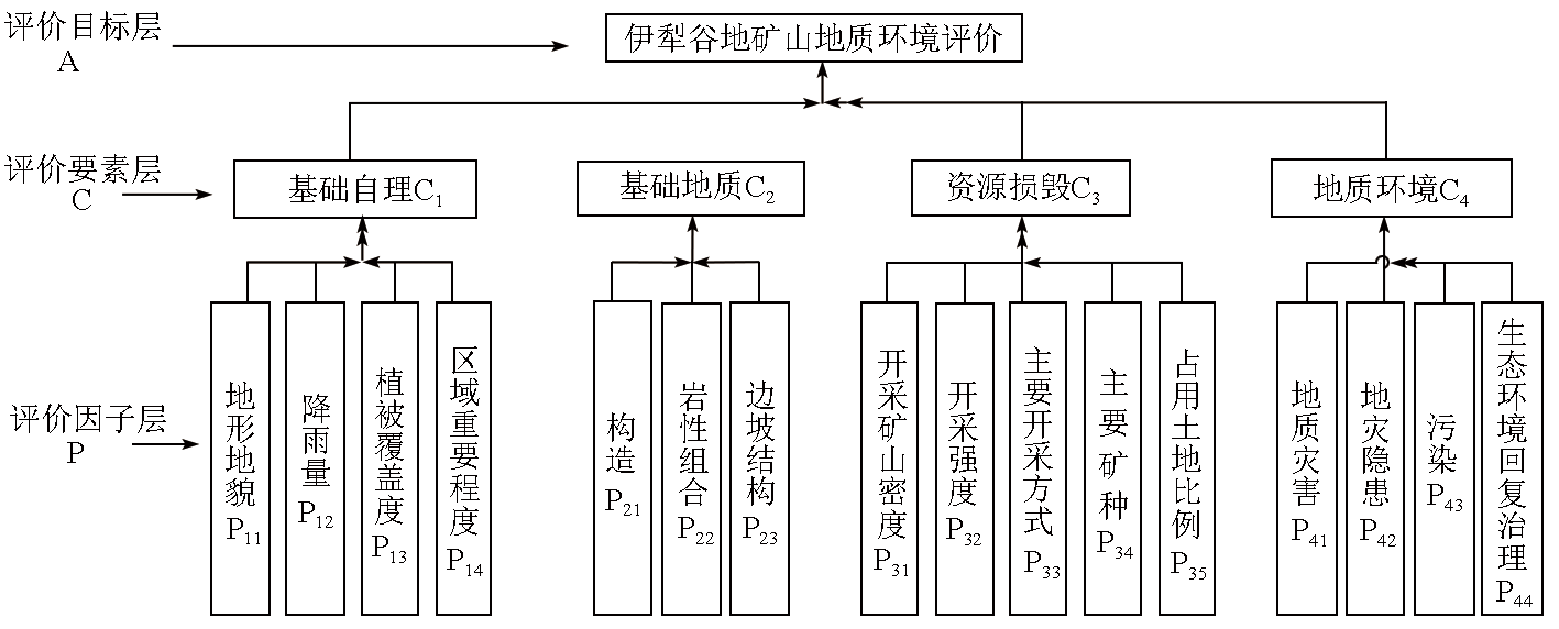
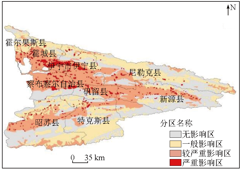
This study aims to evaluate and analyze the geology of mines in Ili Valley and investigate the countermeasures for ecological restoration therein. Utilizing the mining development status derived from remote sensing data and the remote sensing survey results of geological environment, as well as multi-source geological, socio-economic, and meteorological data, this study built a hierarchy structural model using analytic hierarchy process (AHP) and assessed the geological environment of mines in the Ili Valley, The results indicate that the severely affected areas are relatively concentrated, accounting for 4.61% of the total area of Ili Valley. The moderately severely affected areas present a continuous distribution. These areas overlap with each other, exhibiting indistinct boundaries. The generally affected areas are primarily distributed in extremely high mountain areas, medium to high mountain areas, and low mountain and hilly areas. The unaffected areas are primarily distributed in the alluvial plain area in the central part Ili River Valley and the plain area of the Zhaosu Basin. The areas with high ecological carrying capacity are mainly concentrated in the central region except for the south of Zhaosu County and Tekes County, the eastern edge of Nilka County, and the northern area of Khorgos. This study proposed corresponding ecological restoration and management measures and countermeasures against major geological issues. The findings of this study can provide basic data and technical support for the sustainable development of the ecology and the rational exploitation of mine resources in the Ili Valley. Additionally, these findings can serve as a case study for monitoring and assessing the geology of mines in arid and semi-arid areas.
赵玉灵, 杨金中, 孙卫东, 于浩, 邢宇, 陈栋, 马新营, 王体鑫, 王聪. 伊犁河谷矿山地质环境评价分析与生态恢复治理对策[J]. 自然资源遥感, 2024, 36(4): 23-30.
ZHAO Yuling, YANG Jinzhong, SUN Weidong, YU Hao, XING Yu, CHEN Dong, MA Xinying, WANG Tixin, WANG Cong. Evaluation and analysis of geological environment of mines in the Ili Valley and countermeasures for ecological restoration and management. Remote Sensing for Natural Resources, 2024, 36(4): 23-30.
Ministry of Land and Resources. DZ/T 0266—2014 Regulation on remote sensing monitoring of mining exploration[S]. Beijing: Standards Press of China, 2014.
Zhao Y L. Study and application of analytic hierarchy process of mine geological environment:A case study in Hainan Island[J]. Remote Sensing for Land and Resource, 2020, 32(1):148-153.doi:10.6046/gtzyyg.2020.01.20.
Zhao Y L, Yang J Z, Xing Y, et al. Report on remote sensing investigation and evaluation of the suitability for ecological restoration of mines in the Ili Valley[R]. Beijing: China Aero Geophysical Survey and Remote Sensing Center for Natural Resources, 2023.
Xu Q, Xu H L, Xia G Z, et al. Cognition and consideration on ecological restoration of mines in Xinjiang[J]. Journal of Xinjiang Normal University(Natural Sciences Edition), 2022, 41(3): 29-34.
Yu Z Y, Parati A, Wu X X, et al. Environmental geology hazard of mine in Xinjiang and its control strategy[J]. Journal of Natural Disasters, 2007, 16(4):66-69.
Chen C, Zhang Z, Wang W J, et al. Study on Yili River valley area ecological carrying capacity based on GIS[J]. Journal of Environmental Engineering Technology, 2013, 3(6):532-539.
Fu Q, Yang D G, Zhang X H, et al. Time and space differentiation of relative carrying capacity of resources in Ili based on improved model[J]. Journal of University of Chinese Academy of Sciences, 2016, 33(2):170-177.
doi: 10.7523/j.issn.2095-6134.2016.02.005
Yao F L. Study on economic and resource-environment coupling in Yili valley[J]. Journal of Yili Normal University (Natural Science Edition), 2013, 7(3):63-67.
Qiang J H, Yu H. Review on remote sensing monitoring results of mine geological environment in Xinjiang[J]. Geological Survey of China, 2016, 3(5):28-34.
Qiang J H. Application of remote sensing techniques in mine environment investigation and ecological restoration in southern Xinjiang[J]. Northwestern Geology, 2021, 54(3): 253-258.
Zheng G Y, Zhang W T, Li J G, et al. Effect of several types of vegetation on soil and water conservation in Ili River Valley[J]. Journal of Anhui Agricultural Sciences, 2017, 45(1):64-66,78.
Zhao J, Li Z W. Geological environment impact assessment of mine in Tongling based on AHP and fuzzy mathematics comprehensive evaluation[J]. Modern Mining, 2023, 39(3):36-41.
Qiao X J. The application of hierarchy analysis method in the impact assessment of mine geological environment[J]. Shanxi Architecture, 2012, 38(11):66-67.
Li L, Sun Y Q, Li J, et al. Comprehensive evaluation of mine geological environment in Jiangsu Province based on analytic hierarchy process[J]. Resources Economization and Environmental Protection, 2020(5):10-12.
Wang J, Liu X Y, Yang J Z, et al. Typical model analysis of mine geological environment restoration and management in Zhejiang Province based on domestic high-resolution satellite data[J]. Remote Sensing for Land and Resources, 2020, 32(3):216-221.doi: 10.6046/gtzyyg.2020.03.28.
Yin Y Q, Jiang C H, Ju X, et al. Remote sensing evaluation of mine geological environment of Hainan Island in 2018 and ecological restoration countermeasures[J]. Remote Sensing for Natural Resources, 2022, 34(2):194-202.doi: 10.6046/zrzyyg.2021136.
Xiao S Y, Liu F, Wang L X. Discussion on comprehensive management of ecological environment restoration in iron mines[J]. Technology Wind, 2018(3):131.
[21]
英树威. 铁矿矿山生态环境恢复治理方案研究[J]. 科技资讯, 2011, 9(13):156.
Ying S W. Study on ecological environment restoration and treatment scheme of iron mine[J]. Science and Technology information, 2011, 9(13):156.
Li X M, Wang X Y, Jiang L, et al. Advance of phytoremediation technology in tailings treatment[J]. Environmental Science and Technology, 2019, 32(5):71-75.
Tian Hua Mine Co.Ltd. Geological environment protection and land reclamation plan for Songhu Iron Mine in Nileke Country[R]. Ili: Tian Hua Mine Co.Ltd., 2020.
 2024, Vol. 36
  ), 杨金中1, 孙卫东2, 于浩2, 邢宇1, 陈栋1, 马新营1, 王体鑫1, 王聪1