Remote sensing evaluation of mine geological environment of Hainan Island in 2018 and ecological restoration countermeasures
YIN Yaqiu1(), JIANG Cunhao1, JU Xing1, CHEN Keyang2, WANG Jie1, XING Yu1
1. China Aero Geophysical Survey and Remote Sensing Center for Natural Resources, Beijing 100083, China 2. Ningbo Natural Resources Management and Reservation Center, Ningbo 315042, China
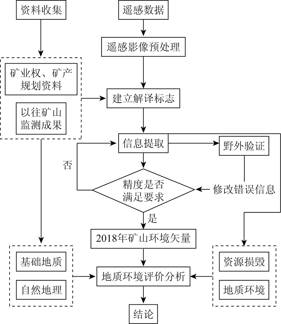
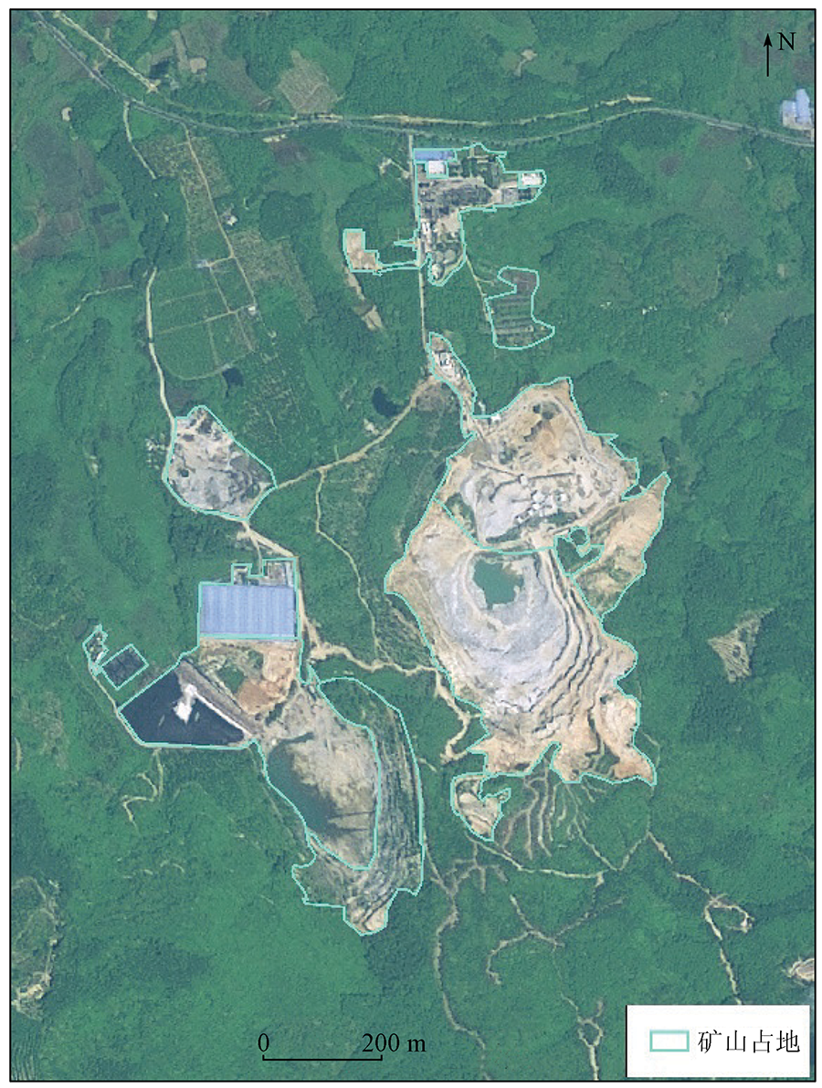
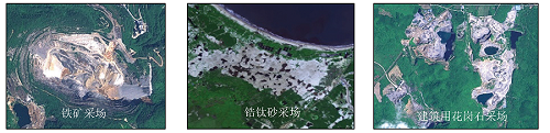
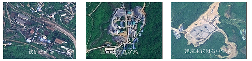
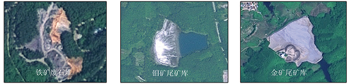
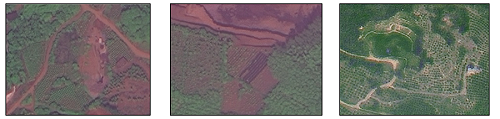
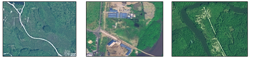
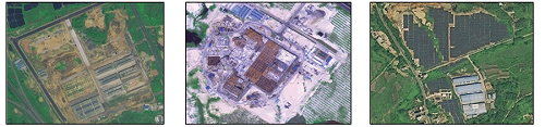
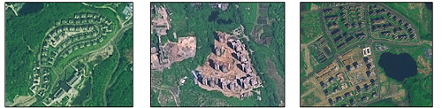
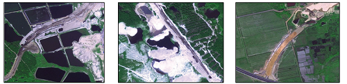
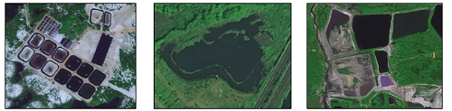
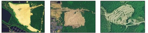
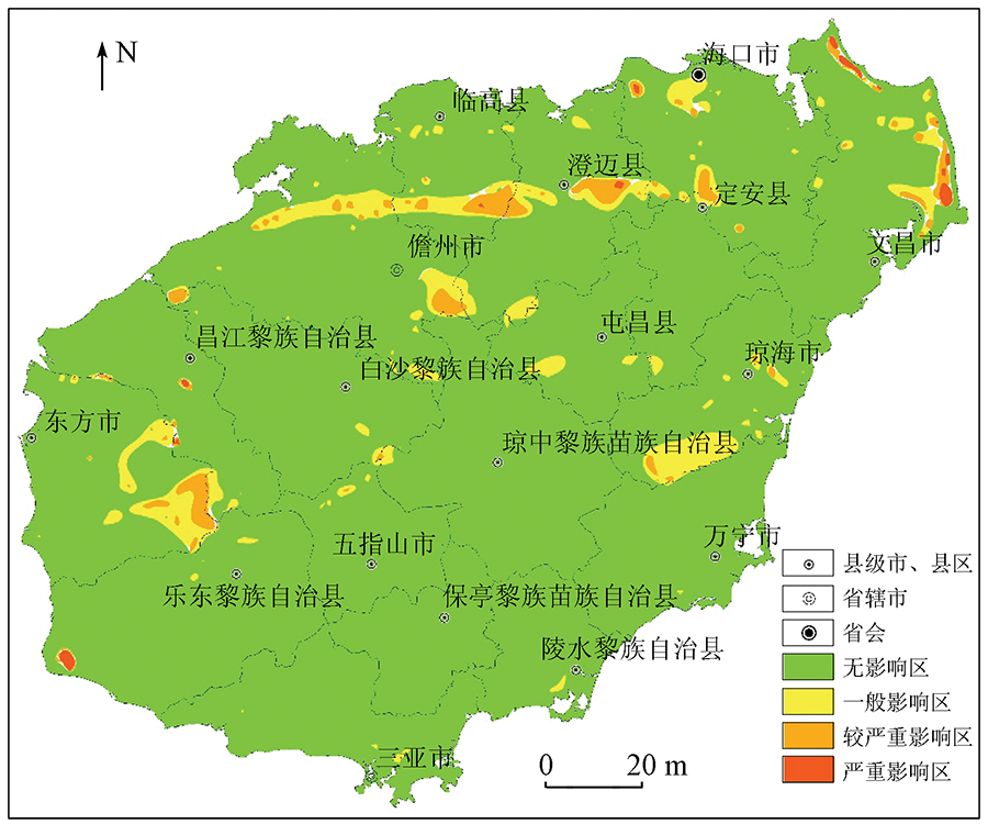
The exploitation of rich and unique mineral resources in Hainan Island has promoted economic growth but has also caused serious ecological environment problems. Analyzing the impacts of mining in Hainan Island and proposing suggestions on ecological restoration facilitate the protection and management of the ecological environment in Hainan Island. To this end, this study obtained the information on land destruction and ecological restoration of mines in Hainan Island using 2018 remote sensing images with high spatial resolution through image preprocessing, establishing interpretation indicators, and man-machine interactive interpretation. Specifically, with the information on land destruction and ecological restoration of mines as input, the assessment indicator system for mine geological environment was established based on 13 assessment factors of four categories, namely physical geography, basic geology, resource damage, and geological environment. Then, this study analyzed and assessed the effects of the geological environment of mines based on the analytic hierarchy process, obtaining the following results. The severely affected areas account for 0.22% of the total land area of Hainan Province and are mainly distributed in Wenchang City, Ledong Li Autonomous County, Xiuying District of Haikou City, Chengmai County, Lin’gao County, and Changjiang Li Autonomous County. The mine geological environment problems in these areas mainly include secondary geological disasters such as mining collapse of goaves and landslides caused by the mining of large-scale iron ore mines, as well as soil erosion and ecosystem degradation caused by the mining of coastal zirconium-titanium placers. The moderately severely affected areas account for 1.68% of the total land area of Hainan Province and are mainly distributed in Wenchang City, Danzhou City, Chengmai County, Qionghai City, Lin’gao County, Haikou City, and Dongfang City. The mine geological environment problems mainly include land damage caused by landslides induced by the mining of small- and medium-sized iron ore mines, as well as severe impacts on original terrain and landforms and the natural ecological environment caused by mining. The generally affected areas account for 4.93% of the total land area of Hainan Province and are mainly distributed in the coastal areas in the eastern part, the economically developed areas in the middle and northern parts, and the area with rich metallic minerals in the western part in Hainan Province. The mine geological environment problems in these areas mainly include the destruction of the surface landforms and natural vegetation caused by the mining of the scattered small nonmetal mines of building materials. This study proposed ecological restoration countermeasures targeting the different geological environment problems. For metal mines, it is suggested to primarily restore the ecosystem by natural restoration methods, supplemented by artificial restoration methods based on the elimination of geological hazards, soil improvement, and water environment management. For zirconium-titanium placers and nonmetal mines of building materials, it is recommended to restore vegetation to prevent water and soil erosion. For the coastal mine areas with severe desertification, it is recommended to gradually restore the ecosystem of the mining areas by growing crops such as watermelons and peanuts to improve soil and planting trees such as casuarina and Vatican hainanensis.
Wen N, Zhang Z R, Wang X T, et al. Achievement of mineral exploration:Summary of important geological prospecting achievement of Hainan bureau of geology and mineral exploration and development during the tenth five-year plan period[C]// “Tenth Five-year Plan” Important Geological Science and Technology Achievements and Important Prospecting Achievements Exchange Meeting.Geological Society of China, 2006:194-196.
[2]
李鹏伟. 海南省矿山开发状况及恢复治理遥感监测[D]. 北京: 中国地质大学(北京), 2020.
Li P W. Remote sensing monitoring of mine development and restoration in Hainan Province[D]. Beijing: China University of Geosciences(Beijing), 2020.
Tong C L. Classification and metallogenic characteristics of sea sand resources in Hainan Island.[J]. Geological Survey of China, 2018, 5(3):74-80.
[4]
余海青. 海南省海洋经济现状及战略研究[D]. 天津: 天津大学, 2009.
Yu H Q. Present situation and strategy of marine economy in Hainan Province[D]. Tianjin: Tianjin University, 2009.
[5]
王堂源. 海南省海岸带生态环境可持续发展实证研究[D]. 成都: 成都理工大学, 2011.
Wang T Y. An empirical study on sustainable development of ecological environment in coastal zone of Hainan Province[D]. Chengdu: Chengdu Univerisity of Technology, 2011.
[6]
黄萍. 自然资源使用权制度研究[D]. 上海: 复旦大学, 2012.
Huang P. Study on the system of use right of natural resources[D]. Shanghai: Fudan University, 2012.
Wang R S, Xiong S Q, Nie H F, et al. Remote sensing technology and its application in geological exploration[J]. Acta Geologica Sinica, 2011, 85(11):1699-1743.
[8]
关涛. 中国土地资源配置与可持续发展研究[D]. 黑龙江: 东北农业大学, 2002.
Guan T. Research on the allocation and sustainable development of land resources in China[D]. Heilongjiang: Northeast Agricultural University, 2002.
[9]
邓辉. 高精度卫星遥感技术在地质灾害调查与评价中的应用[D]. 成都: 成都理工大学, 2007.
Deng H. Application on investigation and evaluation of geohazard by high-precision satellite remote sensing technique[D]. Chengdu: Chengdu University of Technology, 2007.
Wang J, Liu X Y, Yang J Z, et al. Typical model analysis of mine geological environment restoration and management in Zhejiang Province based on domestic high-resolution satellite data[J]. Remote Sensing for Land and Resources, 2020, 32(3):216-221.doi: 10.6046/gtzyyg.2020.03.28.
doi: 10.6046/gtzyyg.2020.03.28
Wang J, Yin Y Q, Yu H, et al. Remote sensing monitoring of mine geological environment in Zhejiang Province based on RS and GIS[J]. Remote Sensing for Land and Resources, 2020, 32(1):232-236.doi: 10.6046/gtzyyg.2020.01.31.
doi: 10.6046/gtzyyg.2020.01.31
Gao J H, Liu S S, Yang J Z, et al. Gray correlation evaluation of geo-logical environment in the open-pit coal mine concentration area based on remote sensing: A case study of the Zhungeer Coalfield[J]. Remote Sensing for Land and Resources, 2021, 33(1):183-190.doi: 10.6046/gtzyyg.2020006.
doi: 10.6046/gtzyyg.2020006
Zhao Y L. Study and application of analytic hierarchy process of mine geological environment: A case study in Hainan Island[J]. Remote Sensing for Land and Resources, 2020, 32(1):148-153.doi: 10.6046/gtzyyg.2020.01.20.
doi: 10.6046/gtzyyg.2020.01.20
Yin Y Q, Yang J Z, Wang J, et al. Remote sensing survey of land occupied and damaged by abandoned mines along the Yangtze River Economic Belt and research on ecological remediation countermeasures[J]. Remote Sensing for Land and Resources, 2020, 32(2):170-176.doi: 10.6046/gtzyyg.2020.02.22.
doi: 10.6046/gtzyyg.2020.02.22
Wang B. Topographic and geomorphic information extraction and landscape pattern analysis of land use in Hainan Island based on Aster G-Dem[D]. Haikou: University of Hainan, 2010.
[16]
卢俊培. 海南大农业的命脉——森林[J]. 热带林业科技, 1981(4):1-6.
Lu J P. The lifeblood of great agriculture in Hainan:Forest[J]. Tropical Forestry Science and Technology, 1981(4):1-6.
Zhao Y L, Yang J Z, Yin Y Q, et al. Research on remote sensing monitoring of zirconium-titanium sand mine exploitation and strategies of ecological restoration on the eastern beach of Hainan Island[J]. Remote Sensing for Land and Resources, 2019, 31(4):143-150.doi: 10.6046/gtzyyg.2019.04.19.
doi: 10.6046/gtzyyg.2019.04.19
[20]
高静. 海南岛东部滨海砂矿废弃地植被恢复效应的比较研究[D]. 海口: 海南师范大学, 2007.
Gao J. Comparative study on vegetation restoration effect of coastal placer abandoned land in eastern Hainan Island[D]. Haikou: Hainan Normal University, 2007.
 2022, Vol. 34
  ), 蒋存浩1, 鞠星1, 陈科玚2, 汪洁1, 邢宇1