Please wait a minute...
 
自然资源遥感  2025, Vol. 37 Issue (2): 164-172    DOI: 10.6046/zrzyyg.2023369
  技术应用 本期目录 | 过刊浏览 | 高级检索 |
张北地区自然资源及生态状况综合评价与分析
张静1,2,3(), 胡晓佳1,2,3(), 王威1,2,3, 陈东磊1,2,3, 黄旭红1,2,3, 杨俊泉1,2,3
1.中国地质调查局天津地质调查中心,天津 300170
2.华北地质科技创新中心,天津 300170
3.天津市海岸带地质过程与环境安全重点实验室,天津 300170
Comprehensive assessment and analysis of natural resources and ecological conditions in the Zhangbei area
ZHANG Jing1,2,3(), HU Xiaojia1,2,3(), WANG Wei1,2,3, CHEN Donglei1,2,3, HUANG Xuhong1,2,3, YANG Junquan1,2,3
1. Tianjin Center, China Geological Survey, Tianjin 300170, China
2. North China Center of Geoscience Innovation, Tianjin 300170, China
3. Tianjin Key Laboratory of Coast Geological Processes and Environmental Safety, Tianjin 300170, China
全文: PDF(4404 KB)   HTML  
输出: BibTeX | EndNote (RIS)      
摘要 为探究农牧交错地区自然资源要素的本底条件以及生态状况的动态分布情况,该文以张北地区为研究区,综合考虑土地资源、植被资源、地下水资源以及矿产资源4个方面,选取15个评价因子,基于层次分析法完成了研究区自然资源要素综合评价,同时基于Google Earth Engine(GEE)平台分别计算了2019—2022年年均遥感生态指数(remote sensing ecological index,RSEI),并在此基础上结合要素和生态分布状况划分了6个生态功能区。结果发现: 研究区自然资源优势度以及RSEI空间上呈现出自环南部低山区向西北丘陵区逐渐降低的趋势,研究区自然资源优势度处于中等优势度状态,RSEI均超过0.52,整体情况相对比较良好; 自然资源优势度评价结果与RSEI有较为密切的关系,呈现出空间上的正相关,验证了自然资源本底要素对于生态状况的重要性。该文提出的生态功能区划可为张北地区的规划发展提供一定的科学参考。
服务
把本文推荐给朋友
加入引用管理器
E-mail Alert
RSS
作者相关文章
张静
胡晓佳
王威
陈东磊
黄旭红
杨俊泉
关键词 农牧交错带层次分析法自然资源优势度遥感生态指数生态功能区划    
Abstract

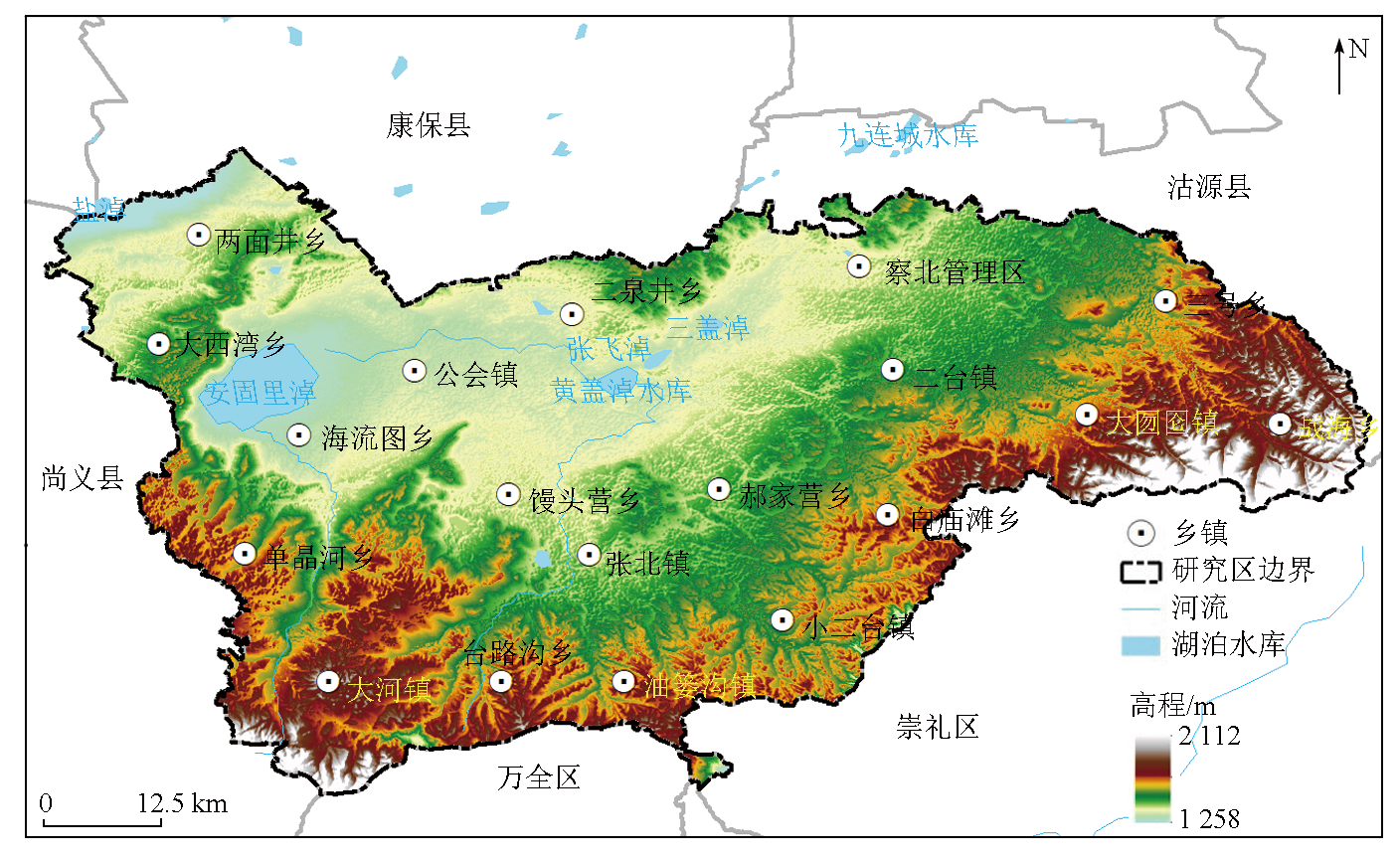
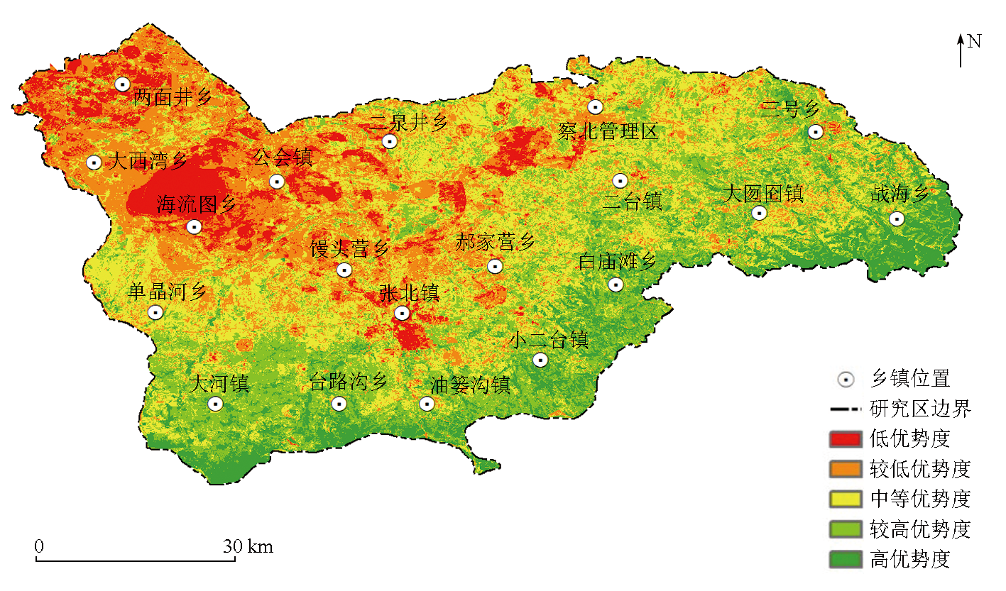
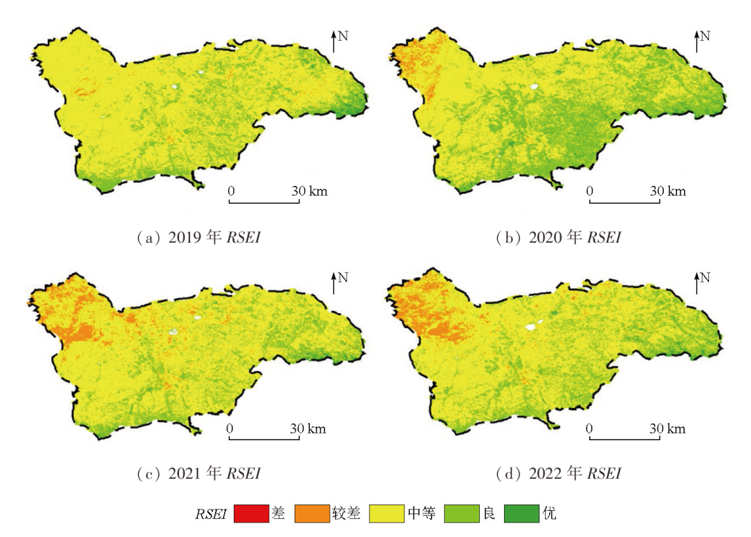
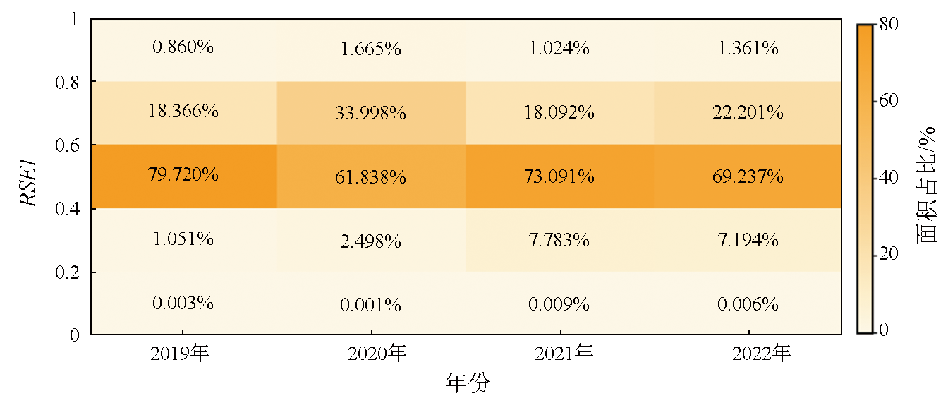
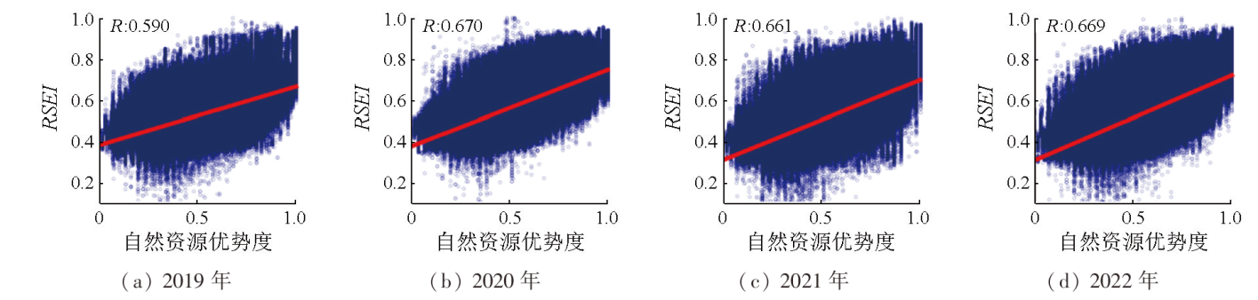
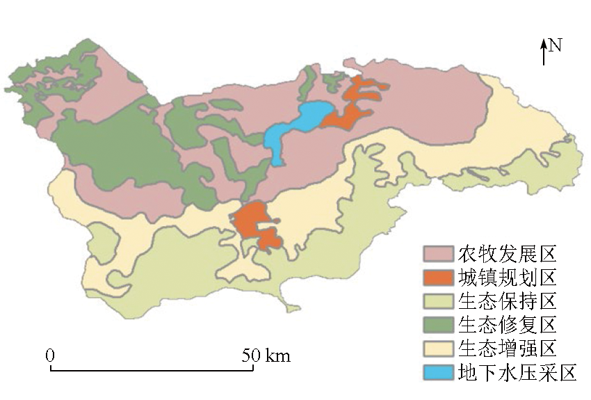
This study aims to explore the background conditions of the natural resource elements and the dynamic distribution of ecological conditions in typical agricultural and pastoral intertwined zones. Focusing on the Zhangbei area, this study selected 15 assessment factors by comprehensively considering four types of resources: land, vegetation, groundwater, and minerals. Accordingly, this study conducted a comprehensive assessment of natural resource elements in the study area using the analytic hierarchy process (AHP). Meanwhile, the 2019—2022 average remote sensing ecological index (RSEI) values were calculated using the Google Earth Engine platform. Based on these results, the study area is divided into six ecological functional zones. The results indicate that from 2019 to 2022, the natural resource dominance and RSEI values of the study area showed a gradual decreasing trend from the low mountainous area encircling the southern part to the hilly area in the northwestern part. The study area exhibited moderate natural resource dominance, with RSEI values all exceeding 0.52. This suggests relatively favorable ecological conditions. In addition, the assessment results of natural resource dominance are closely related to RSEI, showing a positive correlation spatially. This verifies the importance of the background conditions of natural resource elements on ecological status. The ecological function zoning proposed in this study can serve as a scientific reference for the planning and development of Zhangbei areas.

Key wordsagriculture and pastoral intertwined zone    analytic hierarchy process (AHP)    natural resource dominance    remote sensing ecological index (RSEI)    ecological function zoning
收稿日期: 2023-12-13      出版日期: 2025-05-09
ZTFLH:  TP79  
基金资助:国家自然科学基金地质联合基金项目“北方农牧交错带生态退化的地质-生态-水文耦合机制与生态承载力阈值识别”(U2244230);中国地质调查局项目“华北地区自然资源动态监测与风险评估”(DD20230101)
通讯作者: 胡晓佳(1985-),男,硕士,高级工程师,主要从事基础地质和自然资源调查研究。Email: 278558023@qq.com
作者简介: 张 静(1996-),女,硕士,助理工程师,主要从事资源与环境遥感相关研究。Email: 1970331026@qq.com
引用本文:   
张静, 胡晓佳, 王威, 陈东磊, 黄旭红, 杨俊泉. 张北地区自然资源及生态状况综合评价与分析[J]. 自然资源遥感, 2025, 37(2): 164-172.
ZHANG Jing, HU Xiaojia, WANG Wei, CHEN Donglei, HUANG Xuhong, YANG Junquan. Comprehensive assessment and analysis of natural resources and ecological conditions in the Zhangbei area. Remote Sensing for Natural Resources, 2025, 37(2): 164-172.
链接本文:  
https://www.gtzyyg.com/CN/10.6046/zrzyyg.2023369      或      https://www.gtzyyg.com/CN/Y2025/V37/I2/164
Fig.1  研究区区位及地势图
要素 因子 无/不好影响(1分) 一般(3分) 较好(5分) 极好(7分) 因子权重
土地
资源
土地利用分类 城镇村及工矿用地、
交通运输用地
水浇地、旱地、其他林地、其他草地、其他用地 灌木林地、人工牧草地、种植园用地 乔木林地、天然牧草地、湿地、水域 0.072
土壤类型 碱化盐土、草甸碱土、碱化栗钙土、盐化草甸土、盐化栗钙土 草原风沙土、中性石质土、钙质粗骨土、石灰性草甸土、栗钙土 褐土、淋溶褐土、灰褐土、栗褐土、潜育草甸土、暗栗钙土、草甸栗钙土 湖积泥质土(水体) 0.017
土壤养分质量地球化学等级 较缺乏 中等 较丰富 丰富 0.035
土壤质量地球化学综合等级 四等 三等 二等 一等 0.035
盐碱质荒漠化 重度 中度 轻度 无盐渍化 0.121
植被
资源
归一化植被指数 ≤-0.37 (-0.37,-0.21] (-0.21,0] (0,0.56] 0.060
森林蓄积量 ≤-60 (-60,25] (25,33] (33,60] 0.120
草原生物量 [0,600] (600,1 200] (1 200,1 800] (1 800,3 000] 0.120
地下水
资源
地表水质量 Ⅴ级 Ⅵ级 Ⅲ级 Ⅱ级 0.060
地下水开发潜力 中度、轻度超采区、空白区 采补平衡区 较小潜力区 中度潜力区 0.023
地下水质量评价 Ⅴ类 Ⅵ类 Ⅲ类 / 0.060
地下水位 地下水位降落漏斗区 / 其他地区 / 0.157
矿产
资源
开采矿种 能源矿产 金属矿产 非金属矿产 无开发 0.040
开采规模 大型 中型 小型 / 0.040
开采状态 在采 停采 未利用 / 0.040
Tab.1  自然资源要素指标分级体系
Fig.2  研究区自然资源优势度评价结果
序号 区域名称 评价结果 评价等级 序号 区域名称 评价结果 评价等级
1 两面井乡 0.361 较低优势度 11 单晶河乡 0.553 中等优势度
2 公会镇 0.380 较低优势度 12 三号乡 0.599 较高优势度
3 海流图乡 0.401 较低优势度 13 油篓沟镇 0.631 较高优势度
4 大西湾乡 0.414 较低优势度 14 大囫囵镇 0.631 较高优势度
5 馒头营乡 0.459 较低优势度 15 小二台镇 0.653 较高优势度
6 张北镇 0.466 中等优势度 16 大河镇 0.662 较高优势度
7 二泉井乡 0.475 中等优势度 17 白庙滩乡 0.668 较高优势度
8 郝家营乡 0.511 中等优势度 18 台路沟乡 0.701 较高优势度
9 二台镇 0.516 中等优势度 19 战海乡 0.732 高优势度
10 察北管理区 0.518 中等优势度
Tab.2  自然资源优势度区域统计分析结果
Fig.3  研究区2019—2022年RSEI分布图
Fig.4  研究区2019—2022年RSEI不同等级面积占比
Fig.5  RSEI与自然资源优势度的相关分析
Fig.6  研究区生态功能区划图
[1] 沈镭, 钟帅, 胡纾寒. 新时代中国自然资源研究的机遇与挑战[J]. 自然资源学报, 2020, 35(8):1773-1788.
doi: 10.31497/zrzyxb.20200802
Shen L, Zhong S, Hu S H. Opportunities and challenges of natural resources research of China in the New Era[J]. Journal of Natural Resources, 2020, 35(8):1773-1788.
doi: 10.31497/zrzyxb.20200802
[2] 蔡玉梅, 孟超, 周建春, 等. 陆域自然资源综合评价指标体系研究[J]. 测绘科学, 2022, 47(10):168-175.
Cai Y M, Meng C, Zhou J C, et al. Research on the integrated eva-luation indicator system of natural resources[J]. Science of Surveying and Mapping, 2022, 47(10):168-175.
[3] 任春秋, 董斌, 许海锋, 等. 环巢湖自然资源综合评价[J]. 贵州师范大学学报(自然科学版), 2022, 40(6):76-81.
Ren C Q, Dong B, Xu H F, et al. Comprehensive evaluation of na-tural resources around Chaohu Lake[J]. Journal of Guizhou Normal University (Natural Sciences), 2022, 40(6):76-81.
[4] 邱倩倩, 钟丽蓉, 宋玉兵. 江苏省自然资源综合分析评价方法研究[J]. 测绘科学, 2022, 47(8):70-78.
Qiu Q Q, Zhong L R, Song Y B. Study on comprehensive evaluation methods of natural resources in Jiangsu Province[J]. Science of Surveying and Mapping, 2022, 47(8):70-78.
[5] 赵忠琦, 初道忠. 基于主成分分析法对矿产资源自然禀赋综合评价的研究[J]. 中国矿业, 2019, 28(1):52-57,91.
Zhao Z Q, Chu D Z. Research on the natural advantages of mineral resources on principal components analysis[J]. China Mining Ma-gazine, 2019, 28(1):52-57,91.
[6] 刘立程, 孙中孝, 孟超, 等. 中国农业自然资源评价指标体系构建研究[J]. 农业资源与环境学报, 2023, 40(2):468-478.
Liu L C, Sun Z X, Meng C, et al. Evaluating natural agricultural resources in China:A framework and system of indicators[J]. Journal of Agricultural Resources and Environment, 2023, 40(2):468-478.
[7] 王冲, 张景, 彭博, 等. 基于“双评价”的国土空间格局优化研究——以江西省安远县为例[J]. 华北地质, 2023, 46(2):69-78.
doi: 10.19948/j.12-1471/P.2023.02.10
Wang C, Zhang J, Peng B, et al. Research on the optimization of land spatial pattern based on “dual evaluation”:Taking Anyuan County,Jiangxi Province as an example[J]. North China Geology, 2023, 46(2):69-78.
[8] 刘宏伟, 王国明, 马传明, 等. 沉积平原区地下空间开发利用适宜性评价指标体系研究——以北京通州区和河北廊坊北三县为例[J]. 华北地质, 2022, 45(4):68-74.
doi: 10.19948/j.12-1471/P.2022.04.09
Liu H W, Wang G M, Ma C M, et al. Study on evaluation index system of suitability for development and utilization of underground space in sedimentary plain:A case study of Tongzhou District in Beijing and Langfang north three counties in Hebei Province[J]. North China Geology, 2022, 45(4):68-74.
[9] 马小雷, 孟军省, 付丹平. 典型生态脆弱区环境地质问题及防治对策研究——以河北坝上地区为例[J]. 地下水, 2020, 42(2):122-126.
Ma X L, Meng J S, Fu D P. Study on environmental geological problems and prevention countermeasures of typical ecologically vulnerable areas:Take the Bashang area in Hebei as an example[J]. Ground Water, 2020, 42(2):122-126.
[10] 许月卿, 赵菲菲, 孙丕苓. 生态脆弱区土地生态安全动态评价——以河北省张家口市为例[J]. 水土保持通报, 2015, 35(5):232-238.
Xu Y Q, Zhao F F, Sun P L. Evaluation of land ecological security in ecologically fragile area:A case study of Zhangjiakou City,Hebei Province[J]. Bulletin of Soil and Water Conservation, 2015, 35(5):232-238.
[11] 赵玉灵. 基于层次分析法的矿山环境评价方法研究——以海南岛为例[J]. 国土资源遥感, 2020, 32(1):148-153.doi:10.6046/gtzyyg.2020.01.20.
Zhao Y L. Study and application of analytic hierarchy process of mine geological environment:A case study in Hainan Island[J]. Remote Sensing for Land and Resources, 2020, 32(1):148-153.doi:10.6046/gtzyyg.2020.01.20.
[12] 张雅, 尹小君, 王伟强, 等. 基于Landsat8 OLI遥感影像的天山北坡草地地上生物量估算[J]. 遥感技术与应用, 2017, 32(6):1012-1021.
doi: 10.11873/j.issn.1004-0323.2017.6.1012
Zhang Y, Yin X J, Wang W Q, et al. Estimation of grassland aboveground biomass using Landsat8 OLI satellite image in the northern hillside of Tianshan Mountain[J]. Remote Sensing Technology and Application, 2017, 32(6):1012-1021.
[13] 徐婷, 曹林, 佘光辉. 基于Landsat8 OLI的特征变量优化提取及森林生物量反演[J]. 遥感技术与应用, 2015, 30(2):226-234.
doi: 10.11873/j.issn.1004\|0323.2015.2.0226
Xu T, Cao L, She G H. Feature extraction and forest biomass estimation based on Landsat8 OLI[J]. Remote Sensing Technology and Application, 2015, 30(2):226-234.
[14] 张晓东, 刘湘南, 赵志鹏, 等. 基于层次分析法的盐池县地质灾害危险性评价[J]. 国土资源遥感, 2019, 31(3):183-192.doi:10.6046/gtzyyg.2019.03.23.
Zhang X D, Liu X N, Zhao Z P, et al. Geological disaster hazard assessment in Yanchi County based on AHP[J]. Remote Sensing for Land and Resources, 2019, 31(3):183-192.doi:10.6046/gtzyyg.2019.03.23.
[15] 徐涵秋. 城市遥感生态指数的创建及其应用[J]. 生态学报, 2013, 33(24):7853-7862.
Xu H Q. A remote sensing urban ecological index and its application[J]. Acta Ecologica Sinica, 2013, 33(24):7853-7862.
[16] 宋慧敏, 薛亮. 基于遥感生态指数模型的渭南市生态环境质量动态监测与分析[J]. 应用生态学报, 2016, 27(12):3913-3919.
doi: 10.13287/j.1001-9332.201612.024
Song H M, Xue L. Dynamic monitoring and analysis of ecological environment in Weinan City,Northwest China based on RSEI mo-del[J]. Chinese Journal of Applied Ecology, 2016, 27(12):3913-3919.
[17] 陈炜, 黄慧萍, 田亦陈, 等. 基于Google Earth Engine平台的三江源地区生态环境质量动态监测与分析[J]. 地球信息科学学报, 2019, 21(9):1382-1391.
doi: 10.12082/dqxxkx.2019.190095
Chen W, Huang H P, Tian Y C, et al. Monitoring and assessment of the eco-environment quality in the Sanjiangyuan region based on Google Earth Engine[J]. Journal of Geo-information Science, 2019, 21(9):1382-1391.
[18] 王渊, 赵宇豪, 吴健生. 基于Google Earth Engine云计算的城市群生态质量长时序动态监测——以粤港澳大湾区为例[J]. 生态学报, 2020, 40(23):8461-8473.
Wang Y, Zhao Y H, Wu J S. Dynamic monitoring of long time series of ecological quality in urban agglomerations using Google Earth Engine cloud computing:A case study of the Guangdong-Hong Kong-Macao Greater Bay Area,China[J]. Acta Ecologica Sinica, 2020, 40(23):8461-8473.
[19] 排日海, 合力力, 昝梅. 干旱区绿洲城市生态环境时空格局变化及影响因子研究[J]. 自然资源遥感, 2023, 35(3):201-211.doi:10.6046/zrzyyg.2022194.
Pariha H, Zan M. Spatio-temporal changes and influencing factors of ecological environments in oasis cities of arid regions[J]. Remote Sensing for Natural Resources, 2023, 35(3):201-211.doi:10.6046/zrzyyg.2022194.
[1] 奥勇, 汪雅, 王晓峰, 吴京盛, 张亦恒, 李雪娇. 2001—2020年间河南省郑州市生态环境质量时空变化及驱动因素分析[J]. 自然资源遥感, 2025, 37(1): 102-112.
[2] 赵玉灵, 杨金中, 孙卫东, 于浩, 邢宇, 陈栋, 马新营, 王体鑫, 王聪. 伊犁河谷矿山地质环境评价分析与生态恢复治理对策[J]. 自然资源遥感, 2024, 36(4): 23-30.
[3] 赖仕久, 胡晋山, 康建荣, 王小兵. 煤炭资源型区域生态环境演变研究——以山西省为例[J]. 自然资源遥感, 2024, 36(4): 62-74.
[4] 李光哲, 王浩, 曹银璇, 张晓宇, 宁晓刚. 长株潭城市群生态环境质量时空演变及影响因素分析[J]. 自然资源遥感, 2023, 35(4): 244-254.
[5] 袁红, 易桂花, 张廷斌, 别小娟, 李景吉, 王国严, 徐永浩. 基于遥感数据川西高原光伏开发适宜性研究[J]. 自然资源遥感, 2023, 35(4): 301-311.
[6] 王静, 王佳, 徐江琪, 黄邵东, 刘东云. 改进遥感生态指数的典型海岸带城市生态环境质量评价——以湛江市为例[J]. 自然资源遥感, 2023, 35(3): 43-52.
[7] 骆泓鉴, 明冬萍, 徐录. 基于GEE的遥感生态指数时序计算[J]. 自然资源遥感, 2022, 34(2): 271-277.
[8] 张秦瑞, 赵良军, 林国军, 万虹麟. 改进遥感生态指数的宜宾市三江汇合区生态环境评价[J]. 自然资源遥感, 2022, 34(1): 230-237.
[9] 赵龙贤, 代晶晶, 赵元艺, 姜琪, 刘婷玥, 傅明海. 基于RS和GIS技术的西藏多龙矿集区矿山选址研究[J]. 国土资源遥感, 2021, 33(2): 182-191.
[10] 桑潇, 国巧真, 乔悦, 吴欢欢, 臧金龙. 基于多源数据的山西省长治市宜居性研究[J]. 国土资源遥感, 2020, 32(3): 200-207.
[11] 赵玉灵. 基于层次分析法的矿山环境评价方法研究——以海南岛为例[J]. 国土资源遥感, 2020, 32(1): 148-153.
[12] 张晓东, 刘湘南, 赵志鹏, 武丹, 吴文忠, 褚小东. 基于层次分析法的盐池县地质灾害危险性评价[J]. 国土资源遥感, 2019, 31(3): 183-192.
[13] 黄巧, 彭玉玲, 秦文杰. 老挝沙湾水经济区土地利用适宜性评价[J]. 国土资源遥感, 2018, 30(4): 156-162.
[14] 徐志刚, 郑鸿瑞, 戴晨曦, 高鹏, 杜培军. 永定客家土楼世界遗产地土地覆盖与生态变化遥感评价[J]. 国土资源遥感, 2018, 30(1): 102-108.
[15] 张洪敏, 张艳芳, 田茂, 吴春玲. 基于主成分分析的生态变化遥感监测——以宝鸡市城区为例[J]. 国土资源遥感, 2018, 30(1): 203-209.
Viewed
Full text


Abstract

Cited

  Shared   
  Discussed   
京ICP备05055290号-2
版权所有 © 2015 《自然资源遥感》编辑部
地址:北京学院路31号中国国土资源航空物探遥感中心 邮编:100083
电话:010-62060291/62060292 E-mail:zrzyyg@163.com
本系统由北京玛格泰克科技发展有限公司设计开发