Please wait a minute...
 
自然资源遥感  2025, Vol. 37 Issue (3): 162-169    DOI: 10.6046/zrzyyg.2023396
  技术应用 本期目录 | 过刊浏览 | 高级检索 |
轻型无人机在矿产卫片执法中的数据采集及应用研究
陈栋(), 杨金中, 汪洁, 刘琼, 赵玉灵, 李相宜()
中国自然资源航空物探遥感中心,北京 100083
Data acquisition and application of lightweight unmanned aerial vehicles in satellite image-based law enforcement for minerals
CHEN Dong(), YANG Jinzhong, WANG Jie, LIU Qiong, ZHAO Yuling, LI Xiangyi()
China Aero Geophysical Survey and Remote Sensing Center for Natural Resources, Beijing 100083, China
全文: PDF(4083 KB)   HTML  
输出: BibTeX | EndNote (RIS)      
摘要 

在矿产卫片执法工作中,针对地理条件复杂、人员情况不明的矿区,使用无人机对矿区进行侦查、航拍,以及利用摄影测量技术进行矿区的三维建模是保证外业人员人身安全、提高工作效率与准度的一项有效手段。在保证拍摄清晰度与建模数据要求的前提下,轻型无人机起降条件灵活、机动性高,更适合在高流动性矿产卫片执法外业工作中使用。以辽宁省某市几处矿山采面无人机航测成果为例,说明轻型无人机辅助矿产卫片执法工作可以大大提高外业工作效率与安全性,同时建模成果为下一步矿区的精准量测与分析,以及多时序监测提供数据保障。

服务
把本文推荐给朋友
加入引用管理器
E-mail Alert
RSS
作者相关文章
陈栋
杨金中
汪洁
刘琼
赵玉灵
李相宜
关键词 轻型无人机矿产卫片执法摄影测量    
Abstract

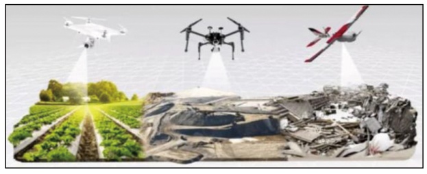
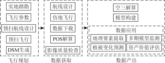
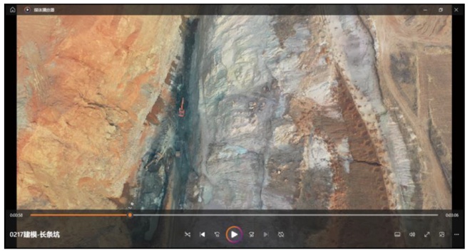
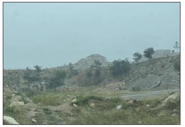
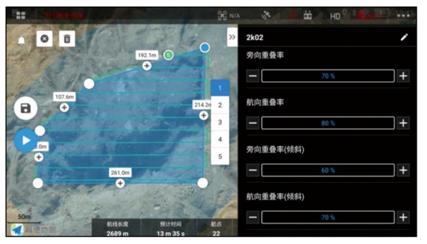
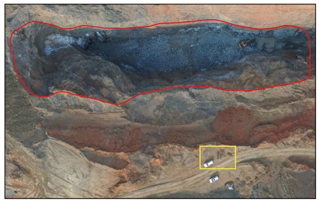
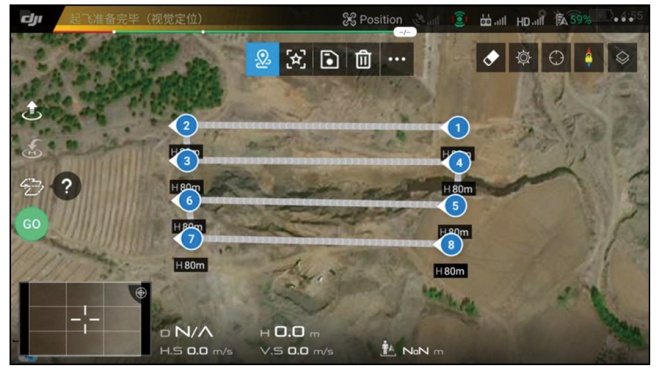
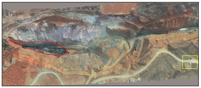
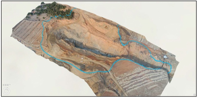
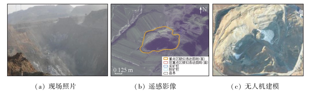
In satellite image-based law enforcement for minerals, using unmanned aerial vehicles (UAVs) for investigation and aerial photography in mining areas with complex geographic conditions and unknown staffing situations, and photogrammetry for three-dimensional modeling of mining areas serves as an effective means to ensure the personal safety of field workers and improve work efficiency and accuracy. Lightweight UAVs are more applicable to satellite image-based law enforcement for highly mobile minerals due to their flexible take-off and landing conditions and high maneuverability while ensuring shooting clarity and modeling data requirements. Based on the UAV aerial survey results of several mining faces in Liaoning Province, this study demonstrates that satellite image-based law enforcement for minerals assisted by lightweight UAVs can significantly improve the efficiency and safety of fieldwork. Moreover, the modeling results provide data support for subsequent accurate survey and analysis and multi-temporal monitoring in mining areas.

Key wordslightweight unmanned aerial vehicle (UAV)    satellite image-based law enforcement for minerals    photogrammetry
收稿日期: 2023-12-22      出版日期: 2025-07-01
ZTFLH:  TP79  
基金资助:中国地质调查局地质调查项目“全国矿山开发及重点地区生态空间监测评估”(102202220120000009066)
通讯作者: 李相宜(1988-),女,硕士,高级工程师,主要从事矿山遥感监测与研究工作。Email: dairywoman@126.com
作者简介: 陈栋(1994-),男,硕士,工程师,主要从事矿山开发修复遥感与信息化技术相关研究。Email: winkies@126.com
引用本文:   
陈栋, 杨金中, 汪洁, 刘琼, 赵玉灵, 李相宜. 轻型无人机在矿产卫片执法中的数据采集及应用研究[J]. 自然资源遥感, 2025, 37(3): 162-169.
CHEN Dong, YANG Jinzhong, WANG Jie, LIU Qiong, ZHAO Yuling, LI Xiangyi. Data acquisition and application of lightweight unmanned aerial vehicles in satellite image-based law enforcement for minerals. Remote Sensing for Natural Resources, 2025, 37(3): 162-169.
链接本文:  
https://www.gtzyyg.com/CN/10.6046/zrzyyg.2023396      或      https://www.gtzyyg.com/CN/Y2025/V37/I3/162
Fig.1  无人机航测技术
Fig.2  无人机航测建模技术路线
参数 数值
尺寸(折叠)/mm 214×91×84(长×宽×高)
尺寸(展开)/mm 322×242×84(长×宽×高)
对角线轴距/mm 354
最大水平飞行速度(海平面附近无风)/(km·h-1) 72(S模式)
最大起飞海拔/m 6 000
最长飞行时间(无风环境)/min 31(25 km/h匀速飞行)
最长悬停时间(无风环境)/min 29
最大续航里程(无风环境)/km 18(50 km/h匀速飞行)
最大抗风等级 5级
起飞质量/g 907
影像传感器 1英寸CMOS
有效像素 2 000万
镜头视角/(°) 77
等效焦距/mm 28
Tab.1  大疆御2Pro主要参数
Fig.3  航线飞行功能示意
Fig.4  矿区实拍照片
Fig.5  矿区正射视频
Fig.6  于起降点拍摄采面方向
Fig.7  倾斜摄影航线及相关参数设置情况
Fig.8  起降点(黄色区域)与采坑(红色区域)位置关系示意图
Fig.9  正射航线及相关参数设置情况
Fig.10  起降点(黄色区域)与采坑(红色区域)位置关系示意图
Fig.11  转为SLPK格式的模型与矢量套合效果
现场 无人机飞行
拍照 视频建模 正射影像建模 倾斜摄影建模
12.6 3.7 5.3 9.1 43.5
Tab.2  各取证方式时间对比
取证方式 现场 无人机飞行
拍照 视频建模 正射影像建模 倾斜摄影建模
无证开采
取证
越界开采
取证
Tab.3  各取证方式取证效果对比
取证方式 现场 无人机飞行
拍照 视频建模 正射影像建模 倾斜摄影建模
方量量测 不可
精细程度
Tab.4  各取证方式精细程度对比
Fig.12  精细程度直观对比
[1] 王甲乙, 侯照亮, 蔡全胜, 等. 无人机在露天金矿区地质填图中的应用[J]. 黄金, 2022, 43(10):4-10.
Wang J Y, Hou Z L, Cai Q S, et al. Application of UAV in open-pit gold district geological field mapping[J]. Gold, 2022, 43(10):4-10.
[2] 崔宏兵, 焦殿阳. 无人机三维建模在矿山执法检查工作中的应用[J]. 测绘与空间地理信息, 2023, 46(7):164-166.
Cui H B, Jiao D Y. Application of UAV 3D modeling in mine law enforcement inspections[J]. Geomatics & Spatial Information Technology, 2023, 46(7):164-166.
[3] 陈浩. 深析无人机测绘技术在矿山监测中的应用研究[J]. 中国金属通报, 2022(9):174-176.
Chen H. Research on the application of UAV surveying and mapping technology in mine monitoring[J]. China Metal Bulletin, 2022(9):174-176.
[4] 宋铁军. 矿山治理工作中应用无人机倾斜摄影测量技术的方法[J]. 中国金属通报, 2023(3):134-136.
Song T J. Application of UAV tilt photogrammetry technology in mine management[J]. China Metal Bulletin, 2023(3):134-136.
[5] 王凯, 王莹, 常勤慧. 无人机倾斜摄影测量在矿山监测中的应用策略分析——以河南A矿山为例[J]. 装备制造技术, 2023(5):240-243.
Wang K, Wang Y, Chang Q H. Application strategy analysis of UAV tilt photogrammetry in mine monitoring—Taking Henan A mine as an example[J]. Equipment Manufacturing Technology, 2023(5):240-243.
[6] 向杰, 陈建平, 李诗, 等. 无人机遥感技术在北京首云铁矿储量动态监测中的应用[J]. 国土资源遥感, 2018, 30(3):224-229.doi: 10.6046/gtzyyg.2018.03.30.
Xiang J, Chen J P, Li S, et al. Research on application of unmanned aerial vehicle technology to dynamic monitoring of reserves in the Shouyun iron mine,Beijing[J]. Remote Sensing for Land and Resources, 2018, 30(3):224-229.doi: 10.6046/gtzyyg.2018.03.30.
[7] 王珏, 郭振, 张志卫, 等. 基于倾斜摄影测量的三维景观指数构建——以山东田横岛为例[J]. 自然资源遥感, 2023, 35(2):112-121.doi: 10.6046/zrzyyg.2022163.
Wang J, Guo Z, Zhang Z W, et al. Construction of 3D landscape indices based on tilt photogrammetry:A case study of Tianheng Island in Shandong Province[J]. Remote Sensing for Natural Resources, 2023, 35(2):112-121.doi: 10.6046/zrzyyg.2022163.
[8] Liu J, Liu H, Liu R, et al. Application of aeromagnetic survey to mineral exploration of Jinping,Yunnan,China by using multirotor UAV[J]. Transactions of Nonferrous Metals Society of China, 2023, 33(5): 1550-1558.
[9] 闫驰, 焦润成, 曹颖, 等. 无人机倾斜摄影在泥石流灾害识别分析中的应用——以北京房山区史家营曹家坊泥石流为例[J]. 国土资源遥感, 2020, 32(4):251-257.doi:10.6046/gtzyyg.2020.04.31.
Yan C, Jiao R C, Cao Y, et al. The application of UAV oblique photography in debris flow disaster identification and analysis:Taking the debris flow in Caojiafang,Shijiaying,FangshanDistrict,Beijing as an example[J]. Remote Sensing for Land and Resources, 2020, 32(4):251-257.doi:10.6046/gtzyyg.2020.04.31.
[10] Cao D, Zhang B, Zhang X, et al. Optimization methods on dynamic monitoring of mineral reserves for open pit mine based on UAV oblique photogrammetry[J]. Measurement, 2023,207:112364.
[11] 李建强. 基于无人机技术的金属矿山地形测绘方法[J]. 中国金属通报, 2023(2):207-209.
Li J Q. Topographic mapping method of metal mines based on UAV technology[J]. China Metal Bulletin, 2023(2):207-209.
[12] 王海成, 温富春, 杨胜兵, 等. 无人机三维扫描实景建模技术的应用探讨[J]. 中文科技期刊数据库(全文版)自然科学, 2023(9):76-78.
Wang H C, Wen F C, Yang S B, et al. Discussion on the application of 3D scanning real scene modeling technology of UAV[J]. Database of Chinese Sci-tech Journals (full-text Edition) Natural Science, 2023(9):76-78.
[13] 卜全民, 赵小乔, 李涛. 无人机倾斜摄影三维实景建模及其优化技术研究[J]. 江苏警官学院学报, 2022, 37(3):122-128.
Bu Q M, Zhao X Q, Li T. Research on 3D reality modeling and optimization technology of UAV oblique photography[J]. Journal of Jiangsu Police Institute, 2022, 37(3):122-128.
[14] 张明明. 矿山测量中无人机测绘技术的应用探讨[J]. 世界有色金属, 2023(7):22-24.
Zhang M M. Discussion on the application of UAV surveying and mapping technology in mine survey[J]. World Nonferrous Metals, 2023(7):22-24.
[15] 宋增巡. 矿山测量中无人机航测系统的应用分析[J]. 矿业装备, 2023(3):186-187.
Song Z X. Application analysis of UAV aerial survey system in mine survey[J]. Mining Equipment, 2023(3):186-187.
[16] 唐小明. 无人机航测系统在地质测绘领域的实践探索[J]. 四川建材, 2021, 47(12):43-44.
Tang X M. Practice and exploration of UAV aerial survey system in geological surveying and mapping field[J]. Sichuan Building Materials, 2021, 47(12):43-44.
[17] 侯中伟, 张昭云. 无人机航测在矿山测绘中的运用分析[J]. 世界有色金属, 2018(5):35,37.
Hou Z W, Zhang Z Y. Application and analysis of unmanned aerial vehicle aerial survey in mine surveying and mapping[J]. World Nonferrous Metals, 2018(5):35,37.
[18] 张登波, 钱玉国. 无人机航摄系统及其在矿山执法中的应用[J]. 江西测绘, 2015(4):45-46.
Zhang D B, Qian Y G. UAV aerial photography system and its application in mine law enforcement[J]. Jiangxi Cehui, 2015(4):45-46.
[19] 樊冠嵩. 无人机航摄在矿山测绘中的应用研究[J]. 信息化建设, 2016(6):341.
Fan G S. Research on the application of UAV aerial photography in mine surveying and mapping[J]. Informatization Construction, 2016(6):341.
[1] 陈凯, 王春, 代文, 盛业华, 刘爱利, 汤国安. 基于控制点蒙特卡罗检验的无人机地形建模精度影响因素研究[J]. 自然资源遥感, 2023, 35(3): 107-115.
[2] 王珏, 郭振, 张志卫, 徐文学, 许昊. 基于倾斜摄影测量的三维景观指数构建——以山东田横岛为例[J]. 自然资源遥感, 2023, 35(2): 112-121.
[3] 张田, 周忠发, 王玲玉, 赵馨, 张文辉, 张淑, 王宇. 基于无人机点云数据土壤粗糙度测量方法[J]. 自然资源遥感, 2023, 35(1): 115-122.
[4] 毕卫华, 赵星涛, 杨化超, 卞和方, 张秋昭. 基于智能手机的无人机低空倾斜摄影测量系统及其应用研究[J]. 国土资源遥感, 2021, 33(2): 248-255.
[5] 向杰, 陈建平, 李诗, 赖自力, 黄浩中, 刘静, 谢帅. 无人机遥感技术在北京首云铁矿储量动态监测中的应用[J]. 国土资源遥感, 2018, 30(3): 224-229.
[6] 余忠迪, 李辉, 巴芳, 王朝阳. 基于消费者级无人机的城市三维建模[J]. 国土资源遥感, 2018, 30(2): 67-72.
[7] 王旭东, 段福洲, 屈新原, 李丹, 余攀锋. 面向对象和SVM结合的无人机数据建筑物提取[J]. 国土资源遥感, 2017, 29(1): 97-103.
[8] 马静, 刘祥磊. 三维可视化在城市旧区改造建设中的应用[J]. 国土资源遥感, 2014, 26(3): 170-174.
[9] 王建超, 郭大海, 郑雄伟. 机载POS直接地理定位软件AeroDG的设计与实现[J]. 国土资源遥感, 2007, 19(4): 28-32.
[10] 王建超, 郭大海, 郑雄伟. 机载POS直接地理定位的精度分析[J]. 国土资源遥感, 2007, 19(4): 33-37.
[11] 郑雄伟, 王建超, 郭大海, 张宗贵. 基于POS系统直接地理定位快速制作DOM[J]. 国土资源遥感, 2007, 19(4): 51-53.
[12] 吴芳, 郑雄伟, 王建超, 郭大海, 张宗贵.  基于POS系统的1∶1万比例尺正射影像图制作[J]. 国土资源遥感, 2007, 19(4): 54-56.
[13] 郭大海, 吴立新, 王建超, 郑雄伟. IMU/DGPS辅助航空摄影新技术的应用[J]. 国土资源遥感, 2006, 18(1): 51-55.
[14] 郭大海, 吴立新, 王建超, 郑雄伟. 机载POS系统对地定位方法初探[J]. 国土资源遥感, 2004, 16(2): 26-31.
[15] 本刊. ERDAS IMAGINE遥感图像处理系统的特点[J]. 国土资源遥感, 2002, 14(3): 78-79.
Viewed
Full text


Abstract

Cited

  Shared   
  Discussed   
京ICP备05055290号-2
版权所有 © 2015 《自然资源遥感》编辑部
地址:北京学院路31号中国国土资源航空物探遥感中心 邮编:100083
电话:010-62060291/62060292 E-mail:zrzyyg@163.com
本系统由北京玛格泰克科技发展有限公司设计开发