Please wait a minute...
 
国土资源遥感  2018, Vol. 30 Issue (4): 102-107    DOI: 10.6046/gtzyyg.2018.04.16
     本期目录 | 过刊浏览 | 高级检索 |
地面沉降光栅立体图研究制作
范景辉1, 王如意2(), 赵红丽1, 李雁明3, 林昊4, 燕云鹏1
1. 中国国土资源航空物探遥感中心,北京 100083
2. 正元地理信息有限责任公司,济南 250101
3. 北京双图华域信息技术有限公司,北京 100083
4. 信阳师范学院,信阳 464000
Research and production of a lenticular stereoscopic subsidence map
Jinghui FAN1, Ruyi WANG2(), Hongli ZHAO1, Yanming LI3, Hao LIN4, Yunpeng YAN1
1. China Aero Geophysical Survey and Remote Sensing Center for Land and Resources, Beijing 100083, China
2. China Zhengyuan Geomatics Co., Ltd., Ji’nan 250101, China;
3. Beijing Graphics and Image Information Technology Co., Ltd., Beijing 100083, China
4. Xinyang Normal University, Xinyang 464000, China
全文: PDF(3600 KB)   HTML  
输出: BibTeX | EndNote (RIS)      
摘要 

光栅立体图在人物、风景、地貌的三维表达方面有着较为广泛的应用,但尚未见于区域地面沉降凹陷形态的表达。在阐述光栅立体成像原理的基础上,以J50幅1:100万地面沉降专题图为数据源,对地面沉降速率等值线进行立体仿真,生成仿真场景的不同视角图像序列,抽样合成为光栅底图,进而将该底图与柱透镜光栅板整合印刷,形成地面沉降光栅立体图。研究表明,利用三维地理信息系统、数字图像处理和光栅立体成像技术,可对地面沉降信息进行新颖、直观的表达。

服务
把本文推荐给朋友
加入引用管理器
E-mail Alert
RSS
作者相关文章
范景辉
王如意
赵红丽
李雁明
林昊
燕云鹏
关键词 光栅立体图地面沉降三维可视化    
Abstract

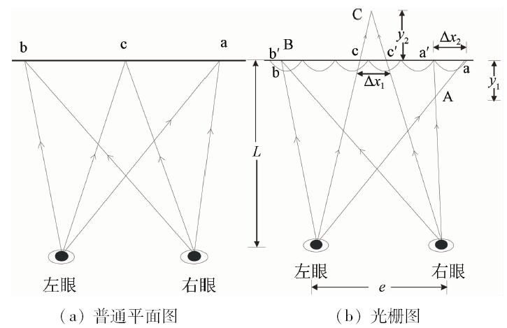
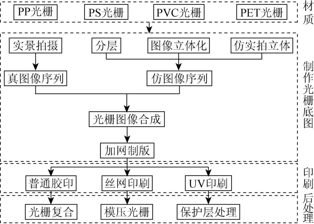
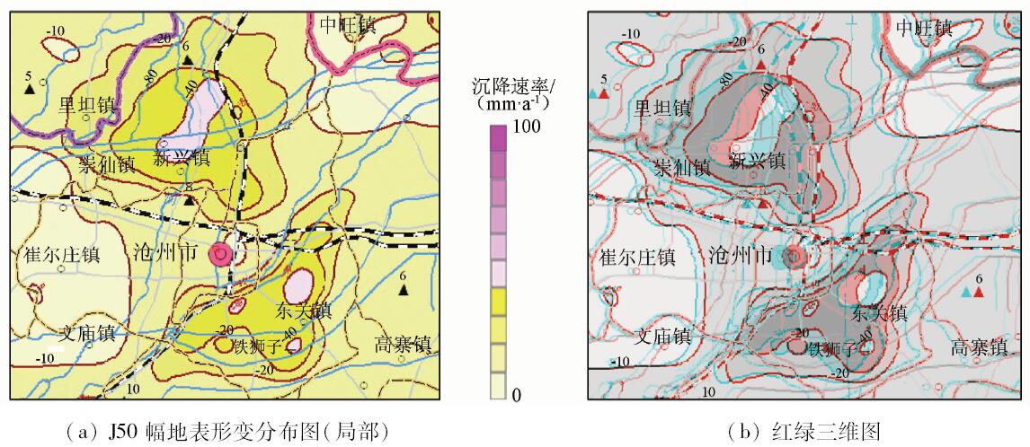
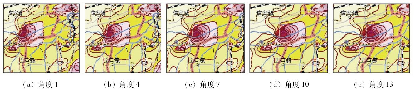
Lenticular stereoscopic images have been widely used in the three-dimensional expression of characters, landscapes and geomorphic features, but they have not yet been found in the visualization of depression shape of regional subsidence. Based on the research and introduction of the lenticular stereoscopic principle, the authors produced a lenticular stereoscopic subsidence map. The J50 thematic map of land subsidence at the scale of 1:1 000 000 was used as the data source. After the three-dimensional simulation using the subsidence isoline, the images series with different viewing angles were generated based on the simulated scene. Then, the images series were sampled and arranged to compose the base map. Finally, the base map was printed on the lenticular plate and properly processed. The research shows that the subsidence field can be innovatively and intuitively visualized using 3D GIS, digital image processing and lenticular stereoscopic technology.

Key wordslenticular stereoscopic map    subsidence    three-dimensional visualization
收稿日期: 2017-04-13      出版日期: 2018-12-07
:  TP79  
基金资助:中国地质调查局项目“全国地表形变遥感地质调查综合研究”(1212011140042);“全国地表形变遥感地质调查”(1212011140040);“青藏冰川变化与冰湖溃决灾害遥感综合调查”(DD20160342);地质大数据支撑平台建设(航遥中心)共同资助(DD20179376)
通讯作者: 王如意
作者简介: 范景辉(1978-),男,博士,教授级高工,主要从事InSAR技术应用研究、3S技术在地质中的应用。Email: jhfan2004@qq.com
引用本文:   
范景辉, 王如意, 赵红丽, 李雁明, 林昊, 燕云鹏. 地面沉降光栅立体图研究制作[J]. 国土资源遥感, 2018, 30(4): 102-107.
Jinghui FAN, Ruyi WANG, Hongli ZHAO, Yanming LI, Hao LIN, Yunpeng YAN. Research and production of a lenticular stereoscopic subsidence map. Remote Sensing for Land & Resources, 2018, 30(4): 102-107.
链接本文:  
https://www.gtzyyg.com/CN/10.6046/gtzyyg.2018.04.16      或      https://www.gtzyyg.com/CN/Y2018/V30/I4/102
Fig.1  光栅示意图
Fig.2  光栅图像立体感形成原理
Fig.3  图像合成光栅底图原理示意图
数据信息类型 数据信息内容
地表形变信息来源 ENVISAT ASAR时间序列数据
提取方法 相干目标短基线时间序列分析
基础地理底图 国家地理信息1:100万数字地形图
投影坐标 高斯-克吕格投影、西安80坐标系
数据周期 2008年1月—2010年10月
制图时间 2011年
制图单位 中国国土资源航空物探遥感中心
Tab.1  地面沉降光栅立体图源数据信息
Fig.4  光栅图制作流程
Fig.5  地面沉降显著区域源图和红绿三维图
Fig.6  不同观察角度的地面沉降场景序列
Fig.7  地面沉降显著区域光栅底图
[1] Roberts D E . History of lenticular and related autostereoscopic methods[Z]. Hillsboro:Leap Technologies,LLC, 2003.
[2] 史瑞芝 . 光栅立体印刷技术综述[J]. 中国印刷与包装研究, 2009,1(5):1-9.
doi: 10.3969/j.issn.1674-5752.2009.05.001
Shi R Z . Summary of grating stereoscopic printing technology[J]. China Printing and Packaging Study, 2009,1(5):1-9.
[3] Johnson R B, Jacobsen G A. Advances in lenticular lens arrays for visual display [C]//Mouroulis P Z,Smith W J,Johnson R B.Current Developments in Lens Design and Optical Engineering VI.San Diego:SPIE, 2005.
[4] Buchroithner M F, Knust C . True-3D in cartography-current hard- and softcopy developments[M] //Moore A,Drecki I.Geospatial Visualisation.Berlin Heidelberg:Springer, 2013: 41-65.
[5] Moellering H . Perspectives on 3D visualization of spatial geodata and future prospects[M] // Buchroithner M.True-3D in Cartography.Berlin Heidelberg:Springer, 2012: 1-19.
[6] 史瑞芝, 安敬 . 一种基于柱镜光栅成像技术制作立体影像图的方法[J].测绘通报, 2008(11):31-33.
Shi R Z, An J . A method of composite stereo photomap based on lenticular screen[J].Bulletin of Surveying and Mapping,2008(11):31-33.
[7] 彭爱华, 朱化凤 . 应用于立体印刷的矩阵式透镜光栅的原理[J]. 燕山大学学报, 2010,34(3):262-265.
doi: 10.3969/j.issn.1007-791X.2010.03.016
Peng A H, Zhu H F . Principium of matrix lens grating in three-dimensional printing[J]. Journal of Yanshan University, 2010,34(3):262-265.
[8] 李鹏 . 立体印刷的成像原理[J].印刷质量与标准化, 2007(3):8-11.
Li P . The imaging elements of 3D printing[J].Printing Quality and Standardization,2007(3):8-11.
[9] 周立权 . 光栅立体印刷图像处理技术研究[J]. 包装工程, 2010,31(3):107-110,136.
Zhou L Q . Research on image-processing technology of stereoscopic printing[J]. Packaging Engineering, 2010,31(3):107-110,136.
[10] 董永贵, 沈立, 冯冠平 , 等. 一种基于柱透镜光栅的计算机辅助彩色立体图片合成方法[J].光学技术, 1999(3):66-68.
doi: 10.3321/j.issn:1002-1582.1999.03.016
Dong Y G, Shen L, Feng G P , et al. Computer-aided composite method of the lenticular screen covering color stereo-image[J].Optical Technology,1999(3):66-68.
[11] 康立民 . 立体照片的拍摄及合成[J]. 北京机械工业学院学报, 1996,11(2):30-42.
Kang L M . Discusses shoot and composite of the stereogram[J]. Journal of Beijing Institute of Machinery Industry, 1996,11(2):30-42.
[12] 大越孝敬. 三维成像技术[M]. 董太和译.北京: 机械工业出版社, 1982.
Takanori. Three-Dimensional Imaging Techniques[M]. Dong T H, transl.Beijing:China Machine Press, 1982.
[13] 侯卫兵 . 大幅面彩色喷涂系统及相关技术的研究[D]. 北京:清华大学, 1997.
[14] Ignat’ev N K . Two modes of operation of a lens array for obtaining integral photography[J]. Soviet Journal of Optical Technology, 1983,50(1):6-8.
[15] Pollard S B, Mayhew J E W, Frisby J P . Implementation details of the PMF stereo algorithm[M] //Mayhew J E W, Frisby J P.3D Model Recognition from Stereoscopic Cues.Cambridge:MIT Press, 1991.
[16] 黄敏, 刘浩学 . 立体印刷制作工艺光栅板参数的选择[J]. 北京印刷学院学报, 2005,13(1):9-12.
Huang M, Liu H X . Selecting of the parameters of cylindrical lens sheet imaging in 3D printing[J]. Journal of Beijing Institute of Graphic Communication, 2005,13(1):9-12.
[17] 范景辉, 李梅, 郭小方 , 等. 基于PSInSAR方法和ASAR数据监测天津地面沉降的试验研究[J]. 国土资源遥感, 2007,19(4):23-27.doi: 10.6046/gtzyyg.2007.04.05.
doi: 10.3969/j.issn.1001-070X.2007.04.005
Fan J H, Li M, Guo X F , et al. A preliminary study of the subsidence in Tianjin area using asar images based on psinsar technique[J]. Remote Sensing for Land and Resources, 2007,19(4):23-27.doi: 10.6046/gtzyyg.2007.04.05.
[18] 王润生, 熊盛青, 聂洪峰 , 等. 遥感地质勘查技术与应用研究[J]. 地质学报, 2011,85(11):1699-1743.
Wang R S, Xiong S Q, Nie H F , et al. Remote sensing technology and its application in geological exploration[J]. Acta Geologica Sinica, 2011,85(11):1699-1743.
[19] 范景辉, 燕云鹏, 葛大庆 , 等. 全国地表形变遥感地质(InSAR)调查技术指南[M]. 北京: 地质出版社, 2015.
Fan J H, Yan Y P, Ge D Q , et al. Technical Guidance on Remote Sensing Geological Survey Based on InSAR for Ground Deformation in China[M]. Beijing: Geological Publishing House, 2015.
[1] 周超凡, 宫辉力, 陈蓓蓓, 雷坤超, 施轹原, 赵宇. 联合WT-RF的津保高铁沿线地面沉降预测[J]. 自然资源遥感, 2021, 33(4): 34-42.
[2] 史珉, 宫辉力, 陈蓓蓓, 高明亮, 张舜康. Sentinel-1A京津冀平原区2016—2018年地面沉降InSAR监测[J]. 自然资源遥感, 2021, 33(4): 55-63.
[3] 于海若, 宫辉力, 陈蓓蓓, 周超凡. 新水情下利用InSAR-GRACE卫星的新兴风险预警与城市地下空间安全展望[J]. 国土资源遥感, 2020, 32(4): 16-22.
[4] 汪宝存, 朱琳, 潘登, 郭凌飞, 彭鹏. 郑州市地面沉降时空演变规律研究[J]. 国土资源遥感, 2020, 32(3): 143-148.
[5] 朱茂, 沈体雁, 黄松, 白书建, 葛春青, 胡琼. InSAR技术地铁沿线建筑物形变监测[J]. 国土资源遥感, 2019, 31(2): 196-203.
[6] 张晓婧, 陈蓓蓓, 雷坤超, 陈文锋, 高明亮, 周超凡, 段光耀. 京津高铁沿线地面沉降特征(北京段)[J]. 国土资源遥感, 2019, 31(1): 171-179.
[7] 张晓博, 赵学胜, 葛大庆, 刘斌, 张玲, 李曼, 王艳. 基于Sentinel TOPS模式Stacking技术监测淮南矿区沉降[J]. 国土资源遥感, 2018, 30(4): 200-205.
[8] 任丽艳, 李英成, 薛艳丽, 丁晓波, 吴豪. 基于北斗技术的无人机飞行监管系统开发与应用[J]. 国土资源遥感, 2018, 30(2): 238-242.
[9] 陈继伟, 曾琪明, 焦健, 赵斌臣. Sentinel-1A卫星TOPS模式数据的SBAS时序分析方法——以黄河三角洲地区为例[J]. 国土资源遥感, 2017, 29(4): 82-87.
[10] 李曼, 葛大庆, 张玲, 刘斌, 郭小方, 王艳. 基于PSInSAR技术的曹妃甸新区地面沉降发育特征及其影响因素分析[J]. 国土资源遥感, 2016, 28(4): 119-126.
[11] 孙晓鹏, 鲁小丫, 文学虎, 甄艳, 王蕾. 基于SBAS-InSAR的成都平原地面沉降监测[J]. 国土资源遥感, 2016, 28(3): 123-129.
[12] 杨成生, 刘媛媛, 敖萌. 基于SBAS时序分析的大同地面沉降与地下水活动研究[J]. 国土资源遥感, 2015, 27(1): 127-132.
[13] 王艳, 张玲, 葛大庆, 张学东, 李曼. 升降轨PSInSAR观测反演沉降与水平向位移试验[J]. 国土资源遥感, 2014, 26(4): 97-102.
[14] 刘钊, 高培超, 闵世平, 赵龙, 罗智德. 一种大曲率线状实体的三维可视化方法[J]. 国土资源遥感, 2014, 26(3): 43-47.
[15] 马静, 刘祥磊. 三维可视化在城市旧区改造建设中的应用[J]. 国土资源遥感, 2014, 26(3): 170-174.
Viewed
Full text


Abstract

Cited

  Shared   
  Discussed   
京ICP备05055290号-2
版权所有 © 2015 《自然资源遥感》编辑部
地址:北京学院路31号中国国土资源航空物探遥感中心 邮编:100083
电话:010-62060291/62060292 E-mail:zrzyyg@163.com
本系统由北京玛格泰克科技发展有限公司设计开发