1.Key Laboratory of Eco-environments in Three Gorges Reservoir Region of Ministry of Education, School of Geographical Science, Southwest University, Chongqing 400715, China 2.Shenzhen Institute of Advanced Technology, Chinese Academy of Sciences, Shenzhen 518055, China
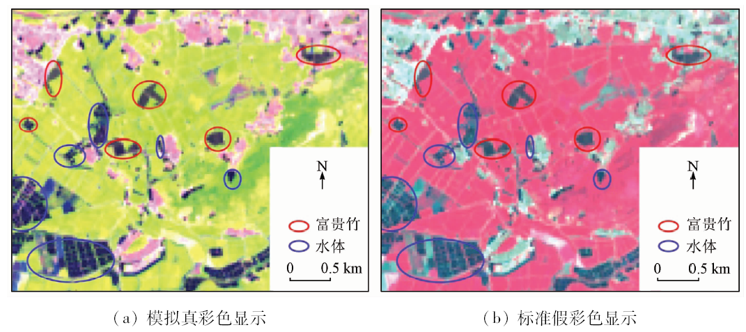
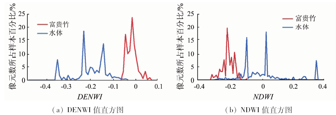
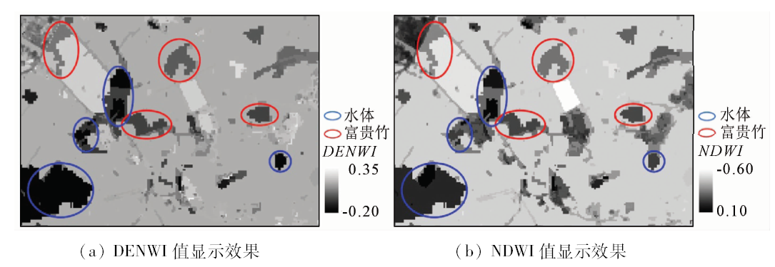
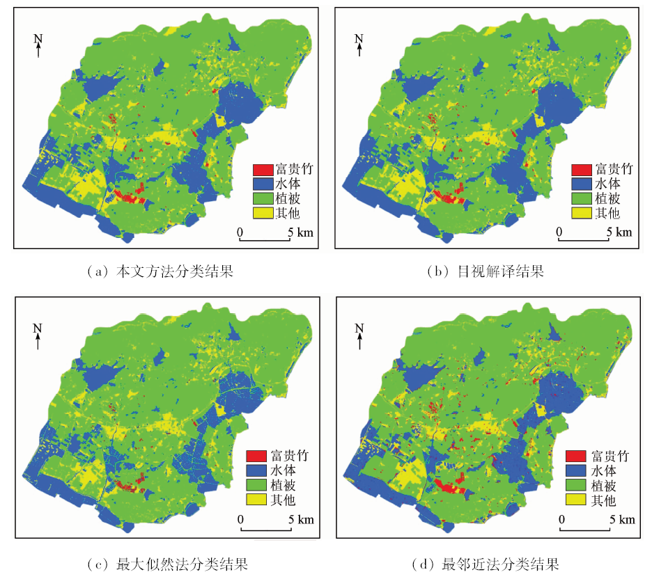
富贵竹作为一种观赏植物,在我国南方省份有大面积种植,具有良好的经济价值。为了解与监测区域富贵竹种植情况,以Landsat8 OLI遥感影像为数据源,构建了一种新的网体—水体差异增强指数(difference enhence between net and water index,DENWI)作为特征参数,通过面向对象的分类方法建立富贵竹信息提取规则集,得到研究区域内富贵竹的种植信息,并与2种传统信息提取方法进行对比研究。结果表明,相比于传统方法,基于DENWI的面向对象分类方法可以更有效地提取富贵竹种植信息,总体分类精度为98.46%,Kappa系数为0.97,该方法监测提取富贵竹种植信息是可行且有优势的,可以为富贵竹种植监测和管理提供科学依据。
The Dracaena sanderiana, as an ornamental plant, has been extensively planted in southern China, and has good economic value. In order to monitor the planting situation of Dracaena sanderiana, the authors constructed a new index-“difference enhence between net and water index”(DENWI) as a characteristic parameter based on Landsat8 OLI remote sensing image. Object-oriented classification method was used to establish the Dracaena sanderiana information extraction rule set, the Dracaena sanderiana planting information was obtained, and two kinds of traditional information extraction methods were adopted for comparative study. The results show that, compared with the traditional method, the object-oriented classification method based on DENWI can extract the information of Dracaena sanderiana, with the overall classification accuracy being 98.46% and the kappa coefficient being 0.97. Remote sensing monitoring and extraction of Dracaena sanderiana planting information is feasible and advantageous, and it can provide scientific basis for monitoring and management of Dracaena sanderiana.
Mao W L, Wang Y, Liu X H . Review of Dracaena sanderiana research[J]. Journal of Jiyuan Vocational and Technical College, 2010,9(4):29-32.
[2]
曹涤环, 刘建武 . 富贵竹栽培管理技术[J]. 南方农业, 2010,4(6):65-67.
Cao D H, Liu J W . Techniques of Dracaena sanderiana’s culture and management[J]. South China Agriculture, 2010,4(6):65-67.
[3]
Tao F L, Yokozawa M, Zhang Z , et al. Remote sensing of crop production in China by production efficiency models:Models comparisons,estimates and uncertainties[J]. Ecological Modelling, 2005,183(4):385-396.
doi: 10.1016/j.ecolmodel.2004.08.023
Song P P, Du X, Wu L C , et al. Research on the method of rice remote sensing identification based on spectral time-series fitting in southern China[J]. Journal of Geo-information Science, 2017,19(1):117-124.
Niu L Y, Zhang X Y, Zheng J Y , et al. Extraction of cultivated land information in Shandong Province based on Landsat8 OLI data[J]. Chinese Agricultural Science Bulletin, 2014,30(34):264-269.
Chen J, Chen T Q, Liu H M , et al. Hierarchical extraction of farmland from high-resolution remote sensing imagery[J]. Transactions of the Chinese Society of Agricultural Engineering, 2015,31(3):190-198.
Liu X L, He C Y, Pan Y Z , et al. Accuracy assessment of thematic classification based on point and cluster sample[J]. Journal of Remote Sensing, 2006,10(3):366-372.
Tian S H, Zhang X F . Random forest classification of land cover information of urban areas in arid regions based on TH-1 data[J]. Remote Sensing for Land and Resources, 2016,28(1):43-49.doi: 10.6046/gtzyyg.2016.01.07.
Li J X, Li Z Q, Li S , et al. The method for semi-automatic extraction of residential area from high resolution remote sensing images[J]. Remote Sensing for Land and Resources, 2017,29(3):17-24.doi: 10.6046/gtzyyg.2017.03.03.
Xu H Q . A new remote sensing index for fastly extracting impervious surface information[J]. Geomatics and Information Science of Wuhan University, 2008,33(11):1150-1153,1211.
Chen Y H, Feng T, Shi P J , et al. Classification of remote sensing image based on object-oriented and class rules[J]. Geomatics and Information Science of Wuhan University, 2006,31(4):316-320.
Yin Z, Zhang J G, Li H B . Application research on information extraction based on high-resolution remote sensing images using object-oriented analysis[J]. Geomatics and Spatial Information Technology, 2013,36(8):61-63.
Yang Q S, Zhang H . A new method for classification of high spatial resolution remotely sensed imagery based on fusion of shape and spectral information of pixels[J]. Remote Sensing for Land and Resources, 2016,28(4):64-70.doi: 10.6046/gtzyyg.2016.04.10.
Guo L, Pei Z Y, Wu Q , et al. Application of method and process of object-oriented land use-cover classification using remote sensing images[J]. Transactions of the Chinese Society of Agricultural Engineering, 2010,26(7):194-198.
Zhuang X Y, Zhao S H, Chen C , et al. Supervised evaluation of optimal segmentation scale with object-oriented method in remote sensing image[J]. Remote Sensing for Land and Resources, 2016,28(4):49-58.doi: 10.6046/gtzyyg.2016.04.08.
[18]
Gorte B . Probabilistic segmentation of remotely sensed images[C]//ITC Publication Series, 1998(63):8-10.
Ma G R, Ma Y L, Jiang M Z . Combinational color histogram and LBP textural features for remote sensing image segmentation[J]. Remote Sensing for Land and Resources, 2017,29(3):32-40.doi: 10.6046/gtzyyg.2017.03.05.
[20]
Hansen M, Dubayah R, Defries R . Classification trees:An alternative to traditional land cover classifiers[J]. International Journal of Remote Sensing, 1996,17(5):1075-1081.
doi: 10.1080/01431169608949069
Zhang L P, Liu Q H, Wang D G , et al. The universal analysis of vegetation indices for hyperspectral remote sensing data[J].Bulletin of Surveying and Mapping, 2010(9):1-4.
 2019, Vol. 31
  ), 陈劲松2