Please wait a minute...
 
国土资源遥感  2020, Vol. 32 Issue (3): 216-221    DOI: 10.6046/gtzyyg.2020.03.28
  矿山遥感调查专栏 本期目录 | 过刊浏览 | 高级检索 |
基于国产高空间分辨率卫星数据的浙江省矿山环境恢复治理典型模式分析
汪洁1(), 刘小杨1, 杨金中1, 周英杰1, 安娜1, 王志晖2
1.中国自然资源航空物探遥感中心,北京 100083
2.中国地质大学(北京)土地科学技术学院,北京 100083
Typical model analysis of mine geological environment restoration and management in Zhejiang Province based on domestic high-resolution satellite data
WANG Jie1(), LIU Xiaoyang1, YANG Jinzhong1, ZHOU Yingjie1, An Na1, WANG Zhihui2
1. China Aero Geophysical Survey and Remote Sensing Center for Natural Resources, Beijing 100083, China
2. School of Land Science and Technology, China University of Geosciences(Beijing), Beijing 100083, China
全文: PDF(6623 KB)   HTML  
输出: BibTeX | EndNote (RIS)      
摘要 

以2016年和2017年获取的2年高空间分辨率卫星影像数据为信息源,对浙江省矿山环境恢复治理情况进行了遥感调查与动态监测。采用国产卫星遥感解译和野外调查的方法,摸清了浙江省矿山恢复治理的现状,根据遥感监测结果和对矿山环境的影像特征总结划分了生态恢复模式、工业园区模式、农用造地模式、景观改造模式、灾害整治模式、综合治理模式6大模式,对其他地区矿山环境恢复治理工作具有借鉴、推广意义。

服务
把本文推荐给朋友
加入引用管理器
E-mail Alert
RSS
作者相关文章
汪洁
刘小杨
杨金中
周英杰
安娜
王志晖
关键词 国产高分卫星遥感监测矿山恢复治理典型模式    
Abstract

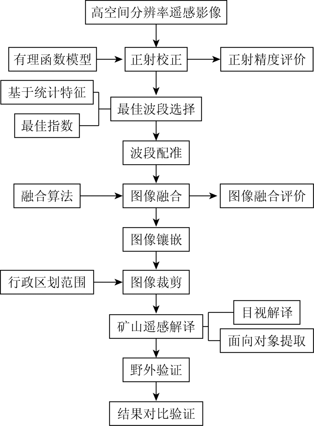
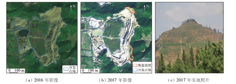
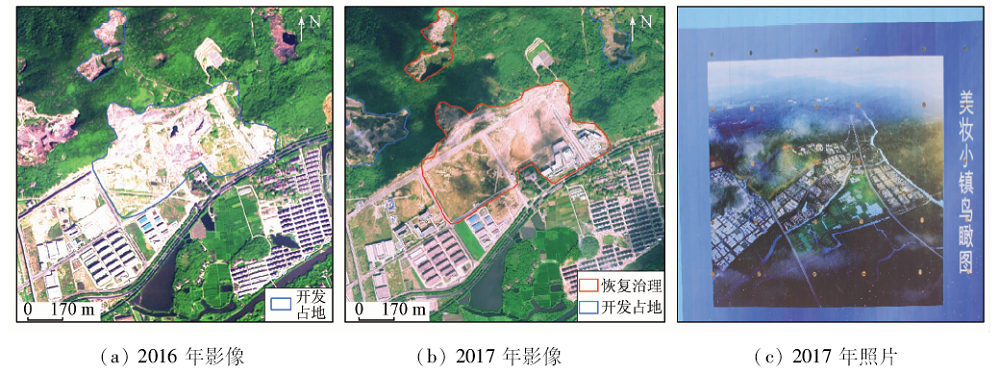
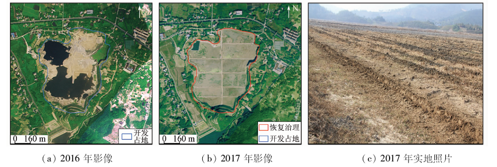
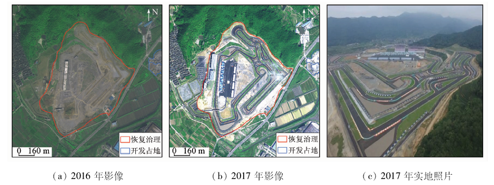
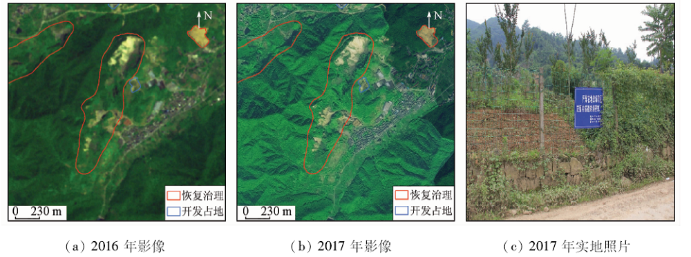
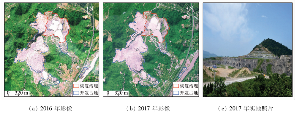
Based on the two-year high-resolution satellite image data acquired in 2016 and 2017, the authors carried out remote sensing investigation and dynamic monitoring of mine geological environment restoration and management in Zhejiang Province. By using the method of interpretation and field investigation by domestic satellite remote sensing, the status quo of mine restoration and management in Zhejiang Province was clarified. According to the results of remote sensing monitoring and impact characteristics, six models were summarized and classified: ecological restoration model, industrial park model, agricultural land-making model, landscape transformation model, disaster management model and comprehensive management model. These six models can be used for reference and promotion of mine geological environment restoration and management in other areas.

Key wordsdomestic high-resolution satellite    remote sensing monitoring    mine recovery and treatment    typical model
收稿日期: 2019-06-06      出版日期: 2020-10-09
:  TP79  
基金资助:中国地质调查局项目“全国矿山开发状况遥感地质调查与监测”(202012000000180606);“全国矿山环境恢复治理状况遥感地质调查与监测”(202012000000180007)
作者简介: 汪洁(1985-),女,硕士,高级工程师,主要研究方向为矿山环境遥感监测。Email: wangsnow2008@163.com
引用本文:   
汪洁, 刘小杨, 杨金中, 周英杰, 安娜, 王志晖. 基于国产高空间分辨率卫星数据的浙江省矿山环境恢复治理典型模式分析[J]. 国土资源遥感, 2020, 32(3): 216-221.
WANG Jie, LIU Xiaoyang, YANG Jinzhong, ZHOU Yingjie, An Na, WANG Zhihui. Typical model analysis of mine geological environment restoration and management in Zhejiang Province based on domestic high-resolution satellite data. Remote Sensing for Land & Resources, 2020, 32(3): 216-221.
链接本文:  
https://www.gtzyyg.com/CN/10.6046/gtzyyg.2020.03.28      或      https://www.gtzyyg.com/CN/Y2020/V32/I3/216
数据类型 辐射量
化级/bit
空间分辨率/m 扫描幅
宽/km
卫星重访
周期/d
光谱波段/nm
全色 多光谱 蓝光 绿光 红光 近红外 全色
GJ-1 11 2 0.5 12 4 630~690 520~590 450~520 770~890 450~890
GF-2 15 4 1 45 5 450~520 520~590 630~690 770~890 450~900
BJ-2 10 4 1 24 1 440~510 510~590 600~670 760~910 450~650
Tab.1  主要数据源参数
Fig.1  技术流程
类型 面积/hm2 占比/%
恢复治理采场 6 483.40 82.70
中转场地 1 094.66 13.96
固体废弃物 153.62 1.96
矿山建筑 14.99 0.19
地质灾害 72.30 0.92
连带治理 20.98 0.27
合计 7 839.95 100.00
Tab.2  矿山环境恢复治理情况统计
Fig.2  上王村龙山废弃矿山遥感影像及实地照片
Fig.3  板庄山石矿遥感影像及照片
Fig.4  虹东石子厂遥感影像及实地照片
Fig.5  牛头颈山石矿遥感影像及实地照片
Fig.6  漓渚铁矿遥感影像及实地照片
Fig.7  新开元石矿遥感影像及实地照片
[1] 杨显华, 黄洁, 田立, 等. 基于高分辨率遥感数据的矿山环境综合治理研究——以冕宁牦牛坪稀土矿为例[J]. 国土资源遥感, 2015,27(4):115-121.doi: 10.6046/gtzyyg.2015.04.18.
doi: 10.6046/gtzyyg.2015.04.18
Yang X H, Huang J, Tian L, et al. A discussion on comprehensive governance of mine environment based onhigh resolution remote sensing data:A case of Maoniuping REE deposit,Mianning County[J]. Remote Sensing for Land and Resources, 2015,27(4):115-121.doi: 10.6046/gtzyyg.2015.04.18.
[2] 姚维岭, 荆青青, 周英杰, 等. 基于遥感动态监测的山东省矿山环境恢复治理典型模式分析[J]. 矿产勘查, 2015,6(5):627-633.
Yao W L, Jing Q Q, Zhou Y J, et al. Analysis on typical pattern of mine geological environment restoration and governance based on remote sensing dynamic monitoring in Shandong[J]. Mineral Exploration, 2015,6(5):627-633.
[3] 黄芳芳, 李艺, 郭秀莲. 广西平乐锰矿露采废弃地的生态恢复模式[J]. 矿业研究与开发, 2011,31(1):88-91.
Huang F F, Li Y, Guo X L. Ecological restoration model of open-pit waste land in Pingle manganese mine Guangxi[J]. Mining R&D, 2011,31(1):88-91.
[4] 陈琪, 赵志芳, 何彬仙, 等. 基于RS和GIS技术的矿山环境恢复与治理规划——以云南省元阳某金矿矿集区为例[J]. 国土资源遥感, 2015,27(3):167-171.doi: 10.6046/gtzyyg.2015.03.26.
doi: 10.6046/gtzyyg.2015.03.26
Chen Q, Zhao Z F, He B X, et al. Environmental recovery and management planning based on RS and GIS techniques:A case study of the Yuanyang gold mining area in Yunnan Province[J]. Remote Sensing for Land and Resources, 2015,27(3):167-171.doi: 10.6046/gtzyyg.2015.03.26.
[5] 王海庆, 陈玲. 西藏日喀则矿山环境恢复治理效果分析[J]. 矿业研究与开发, 2018,38(10):111-114.
Wang H Q, Chen L. Effectiveness analysis on mine environment rehabilitation in Shigatse of Tibet[J]. Mining R&D, 2018,38(10):111-114.
[6] 杨金中, 秦绪文, 聂洪峰, 等. 中国矿山遥感监测[M]. 北京: 测绘出版社, 2014: 27.
Yang J Z, Qin X W, Nie H F, et al. Remote sensing monitoring of mines in China[M]. Beijing: Surveying and Mapping Publishing House, 2014: 27.
[7] 杨金中, 聂洪峰, 荆青青. 初论全国矿山地质环境现状与存在问题[J]. 国土资源遥感, 2017,29(2):1-7.doi: 10.6046/gtzyyg.2017.02.01.
Yang J Z, Nie H F, Jing Q Q. Preliminary analysis of mine geo-environment status and existing problems in China[J]. Remote Sensing for Land and Resources, 2017,29(2):1-7.doi: 10.6046/gtzyyg.2017.02.01.
[8] 陈学军, 宾秀玲. 矿山开发对环境质量的影响[J]. 桂林工学院学报, 1996,16(1):83-86.
Chen X J, Bin X L. Impact of mine development on environmental quality[J]. Journal of Guilin Institute of Technology, 1996,16(1):83-86.
[9] 白光宇, 田磊, 张德强. SPOT5卫星影像在矿山环境调查中的应用[J]. 城市地质, 2016,11(3):83-86.
Bai G Y, Tian L, Zhang D Q. Application of the SPOT5 image in the mine geo-environment investigation[J]. Urban Geology, 2016,11(3):83-86.
[10] 王晓红, 聂洪峰, 李成尊, 等. 不同遥感数据源在矿山开发状况及环境调查中的应用[J]. 国土资源遥感, 2006,18(2):69-71.doi: 10.6046/gtzyyg.2006.02.17.
doi: 10.6046/gtzyyg.2006.02.17
Wang X H, Nie H F, Li C Z, et al. The application of characteristics of different remote sensing data sources to the investigation of the mining situation and environment of mines[J]. Remote Sensing for Land and Resources, 2006,18(2):69-71.doi: 10.6046/gtzyyg.2006.02.17.
[11] 王晓红, 聂洪峰, 杨清华, 等. 高分辨率卫星数据在矿山开发状况及环境监测中的应用效果比较[J]. 国土资源遥感, 2004,16(1):15-18.doi: 10.6046/gtzyyg.2004.01.04.
doi: 10.6046/gtzyyg.2004.01.04
Wang X H, Nie H F, et al.Yang Q H. The different monitoring effects of QuickBird and SPOT-5 data in mine exploitation[J]. Remote Sensing for Land and Resources, 2004,16(1):15-18.doi: 10.6046/gtzyyg2004.01.04.
[12] 张焜, 马世斌, 刘丽萍. 青海省北部重点成矿带与矿集区矿山地质环境遥感监测研究[J]. 西北地质, 2012,45(1):283-292.
Zhang K, Ma S B, Liu L P. Study of remote sensing monitoring concerning geological environment of major metallogenic belt and mining concentrations in the northern Qinghai Province[J]. Northwestern Geology, 2012,45(1):283-292.
[13] 安志宏, 程玉书, 汪宝存, 等. 辽源市矿山地质环境恢复治理遥感监测与整治模式一体化研究[J]. 地质力学学报, 2017,23(4):631-635.
An Z H, Cheng Y S, Wang B C, et al. A study on the integration of remote sensing monitoring and regulation model in restoration and treatment of mine geological environment in Liaoyuan[J]. Journal of Geomechanics, 2017,23(4):631-635.
[14] 聂洪峰, 杨金中, 王晓红, 等. 矿产资源开发遥感监测技术问题与对策研究[J]. 国土资源遥感, 2007,19(4):11-13.doi: 10.6046/gtzyyg.2007.04.03.
doi: 10.6046/gtzyyg.2007.04.03
Nie H F, Yang J Z, Wang X H, et al. The problems in the remote sensing monitoring technology for the exploration of mineral resources and the countermeasures[J]. Remote Sensing for Land and Resources, 2007,19(4):11-13.doi: 10.6046/gtzyyg.2007.04.03.
[15] 吕玉凤. 遥感技术在矿山环境恢复治理中的应用研究[J].科技广场, 2015(8):42-46.
Lyu Y F. Application research of remote sensing technology in mine environment restoration[J].Science Mosaic 2015(8):42-46.
[1] 吕品, 熊丽媛, 徐争强, 周学铖. 基于FME的矿山遥感监测矢量数据图属一致性检查方法[J]. 自然资源遥感, 2022, 34(1): 293-298.
[2] 郭文, 张荞. 基于注意力增强全卷积神经网络的高分卫星影像建筑物提取[J]. 国土资源遥感, 2021, 33(2): 100-107.
[3] 陈栋, 姚维岭. 基于ArcPy与定制ArcToolbox的矿山新增图斑自动编号及方法改进[J]. 国土资源遥感, 2021, 33(2): 262-269.
[4] 刁明光, 刘文静, 李静, 刘芳, 王彦佐. 矿山遥感监测矢量成果数据动态变化检测方法[J]. 国土资源遥感, 2020, 32(3): 240-246.
[5] 冯力力, 江利明, 柳林, 孙亚飞. 新疆克拉牙依拉克冰川变化(1973—2016)主被动遥感监测分析[J]. 国土资源遥感, 2020, 32(2): 162-169.
[6] 石海岗, 梁春利, 张建永, 张春雷, 程旭. 岸线变迁对田湾核电站温排水影响遥感调查[J]. 国土资源遥感, 2020, 32(2): 196-203.
[7] 刘晰, 郝利娜, 杨显华, 黄洁, 张志, 杨武年. 矿山遥感监测指标快速统计方法研究与实现[J]. 国土资源遥感, 2020, 32(2): 259-265.
[8] 汪洁, 殷亚秋, 于航, 蒋存浩, 万语. 基于RS和GIS的浙江省矿山地质环境遥感监测[J]. 国土资源遥感, 2020, 32(1): 232-236.
[9] 赵玉灵, 杨金中, 殷亚秋, 赵航, 何金宝, 张汉. 海南岛东部滨海锆钛砂矿开发状况遥感监测与生态恢复治理对策研究[J]. 国土资源遥感, 2019, 31(4): 143-150.
[10] 吴海平, 黄世存. 基于深度学习的新增建设用地信息提取试验研究——全国土地利用遥感监测工程创新探索[J]. 国土资源遥感, 2019, 31(4): 159-166.
[11] 陈震, 张耘实, 章远钰, 桑玲玲. 高标准农田建后遥感监测方法[J]. 国土资源遥感, 2019, 31(2): 125-130.
[12] 张伟, 齐建伟, 陈颖, 韩旭. 多源国产高分卫星联合区域网平差精度分析研究[J]. 国土资源遥感, 2019, 31(1): 125-132.
[13] 杨显华, 黄洁, 田立, 彭孛, 肖礼晓, 宋新龙. 矿山遥感监测在采空区稳定性分析中的应用[J]. 国土资源遥感, 2018, 30(3): 143-150.
[14] 刁娇娇, 龚鑫烨, 李明诗. 利用综合变化检测方法进行土地覆盖变化制图[J]. 国土资源遥感, 2018, 30(1): 157-165.
[15] 张春桂, 林炳青. 基于FY-2E卫星数据的福建沿海海雾遥感监测[J]. 国土资源遥感, 2018, 30(1): 7-7.
Viewed
Full text


Abstract

Cited

  Shared   
  Discussed   
京ICP备05055290号-2
版权所有 © 2015 《自然资源遥感》编辑部
地址:北京学院路31号中国国土资源航空物探遥感中心 邮编:100083
电话:010-62060291/62060292 E-mail:zrzyyg@163.com
本系统由北京玛格泰克科技发展有限公司设计开发