Application of hyperspectral spectroscopy to constructing polymetallic prospecting model in Hongshan, Gansu Province
WANG Ruijun1(), ZHANG Chunlei1, SUN Yongbin1, WANG Shen1, DONG Shuangfa1, WANG Yongjun1, YAN Bokun2
1. Airborne Survey and Remote Sensing Center of Nuclear Industy, Shijiazhuang 050002, China 2. China Aero Geophysical Survey and Remote Sensing Center for Natural Resources, Beijing 100083, China
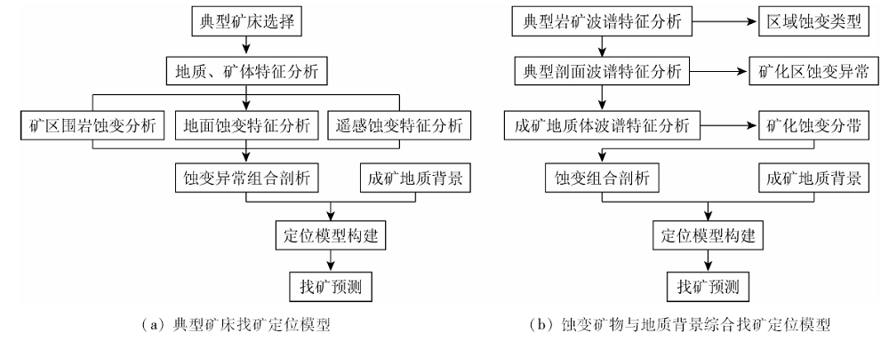
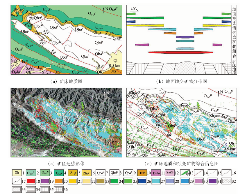
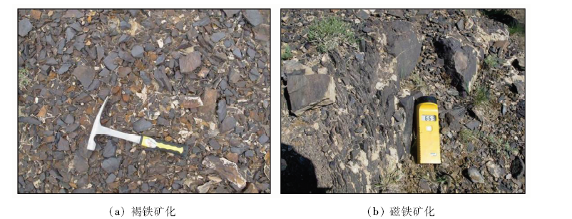
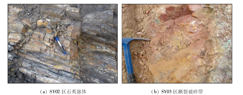
In order to further study and explore the application effect and potential of hyperspectral remote sensing technology in geological prospecting, the authors used the aerial and ground hyperspectral remote sensing data of Hongshan region in Gansu Province to analyze the distribution characteristics of altered minerals or altered anomaly information, summarized the distribution law of altered anomaly of ore-forming geological bodies, and proposed the construction idea of ore-finding positioning model of ore-forming geological environment elements based on alteration information characteristics of known typical deposits, ore-controlling elements and alteration information law of ore-forming geological bodies. The authors gradually revealed the metallogenic geological environment expressed by “minerals-landmark minerals-altered minerals-prospecting anomalies”, and constructed the prospecting positioning model of typical deposits and the comprehensive prospecting positioning model of altered minerals and geological background. Guided by the ore-finding positioning model and combined with geological background and ore-forming laws, the authors applied different models to delineate 4 polymetallic prospective areas. After field investigation, better clues of polymetallic mineralization were found. Practice shows that, by analyzing the intrinsic relationship between hyperspectral alteration information and ore-forming laws, more accurate information can be provided for ore prospecting, and the same kind of polymetallic ore prospecting work can be effectively guided.
王瑞军, 张春雷, 孙永彬, 王诜, 董双发, 王永军, 闫柏琨. 高光谱在甘肃红山多金属找矿模型构建中的应用[J]. 国土资源遥感, 2020, 32(3): 222-231.
WANG Ruijun, ZHANG Chunlei, SUN Yongbin, WANG Shen, DONG Shuangfa, WANG Yongjun, YAN Bokun. Application of hyperspectral spectroscopy to constructing polymetallic prospecting model in Hongshan, Gansu Province. Remote Sensing for Land & Resources, 2020, 32(3): 222-231.
Wang R S, Xiong S Q, Nie H F, et al. Remote sensing technology and its application in geological exploration[J]. Acta Geologica Sinica, 2011,85(11):1699-1743.
Wang R S, Gan F P, Yan B K, et al. Hyperspectral mineral map-ping and its application[J]. Remote Sensing for Land and Re-sources, 2010,22(1):1-13.doi: 10.6046/gtzyyg.2010.01.01.
Yao B Z, He F. Spatial and spectral feature hierarchical fusion for hyperspectral image feature extraction[J]. Remote Sensing for Land and Resources, 2019,31(3):59-64.doi: 10.6046/gtzyyg.2019.03.08.
Yang S R, Xue Z H, Zhang L, et al. Fusion of hyperspectral and LiDAR data:A case study for refined crop classification in agricultural region of Zhangye Oasis in the middle reaches of Heihe River[J]. Remote Sensing for Land and Resources, 2018,30(4):33-40.doi: 10.6046/gtzyyg.2018.04.06.
[5]
Clark R N, Swayze G A, et al. Imaging spectroscopy:Earth and planetary remote sensing with the USGS tetracorder and expert systems[J]. Geophysical Research, 2003,108(e12):5131.
[6]
Berger B R, V V King T, Morath L C, et al. Utility of high-altitude infrared spectral data in mineral exploration:Application to northern Patagonia Mountains,Arizona[J]. Economic Geology, 2003,98(5):1003-1018.
doi: 10.2113/gsecongeo.98.5.1003
[7]
Kruse F A, Hauff P L. Identification of illite polytype zoning in disseminated gold deposits using reflectance spectroscopy and X-ray diffraction-potential for mapping with imaging spectrometer[J]. IEEE Trans actions on Geoscience Remote Sensing, 1991,29(1):101-104.
[8]
Kruse F A, Lefkoff A B, Boardman J W, et al. The spectral image processing system(SIPS)-interactive visualization and analysis of imaging spectrometer data[J]. Remote Sensing of Environment, 1993,44:145-163.
doi: 10.1016/0034-4257(93)90013-N
Gan F P, Wang R S, Ma A N. Spectral identification of high-spectral remote sensing minerals based on characteristic band[J]. Earth Science Frontiers, 2003,10(2):445-454.
[10]
Bierwirth P, Huston D, Blewett R. Hyperspectral mapping of mineral assemblages associated with gold mineralization in the central Pilbara[J]. Western Australia Economic Geology, 2002,97:819-826.
[11]
Cudahy T J, Okada K, Brauhart C. Targeting VMS-style Zn mineralization at Panorama,Australia,using airborne hyperspectral VNIR-SWIR HyMap data [C]//14th Environmental Research Institute of Michigan.International Conference on Applied Geologic Remote Sensing.Las Vegas. 2000: 395-402.
[12]
Brown A J, Cudahy T J, Walter M R. Hydrothermal alteration at the Panorama Formation,North Pole Dome,Pilbara Craton,Western Australia[J]. Precambrian Research, 2006,151:211-223.
doi: 10.1016/j.precamres.2006.08.014
[13]
Bierwirth P, Huston D, Blewett R. Hyperspectral mapping of mineral assemblages associated with gold mineralization in the central Pilbara,Western Australia[J]. Economic Geology, 2002,97:819-826.
doi: 10.2113/gsecongeo.97.4.819
[14]
Bell J H, Bowen B B, Martini B A. Imaging spectroscopy of jarosite cement in the Jurassic Navajo Sandstone[J]. Remote Sensing of Environment, 2010,114:2259-2270.
doi: 10.1016/j.rse.2010.05.002
[15]
Bedini E, van der Meer F, van Ruitenbeek F. Use of HyMap imaging spectrometer data to map mineralogy in the Rodalquilar caldera,southeast Spain[J] International Journal of Remote Sensing, 2009,30(2):327-348.
doi: 10.1080/01431160802282854
Ren G L, Yang J L, Yang M, et al. Application of hyperspectral remote sensing anomaly information on metallogenic prediction in the Jintanzi-Mingjingou area of Beishan,Gansu[J]. Geotectonica et Metallogenia, 2013,37(4):765-776.
Li W Y, Dong F C, Jiang H B, et al. The northwest important metal mineral metallogenic characteristics and ore prospecting potential[J]. Northwestern Geology, 2006,39(2):1-15.
Liu D C, Qiu J T, Tian F, et al. Application of airborne hyper-spectrum remotesensing to mapping of ore-control faults:A case study of the Heishishan-Huaniushan fault[J]. Geology and Exploration, 2015,51(2):366-375.
Wang R J, Li M S, Wang B, et al. Study on spectrogram of altered mineral assemblages and its application in Xiaogangou gold deposit,Qinghai Province[J]. Gold, 2014,35(5):10-15.
Sun Y, Zhao Y J, Li H B, et al. HySpex hyperspectral mineral map-ping of Asiha gold ore district in Dulan County,Qinghai Province and its prospecting implications[J]. Acta Geologica Sinica, 2015,89(1):195-203.
doi: 10.1111/acgs.2015.89.issue-s1
Li Z Z, Yang R H, Dang F X, et al. The hyperspectral remote sensing technology and its application[J]. Geological Bulletin of China, 2009,28(2/3):270-277.
Du X D, Tang Y, Liu D C, et al. The application of aerial hyper-spectral technology to the geological survey for oil and gas in the East Junggar basin[J]. Geology in China, 2015,42(1):275-287.
Yao F J, Yang J M, Zhang Y J, et al. Extraction of remote sensing alteration anomalies of three types of ore deposits and its applica-tion[J]. Acta Petrologica Sinica, 2009,25(4):971-976.
Zhang Z G, Wang R S. Development and application of imaging spectral remote sensing technology based on spectroscopy[J]. Remote sensing of land resources, 2000,12(3):16-37.doi: 10.6046/gtzyyg.2000.03.03.
Ren G L, Yang M, Li J Q, et al. Application of hyperspectral alteration information to gold prospecting:A case study of Fangshankou area,Beishan[J]. Remote Sensing for Land and Resources, 2017,29(3):182-190.doi: 10.6046/gtzyyg.2017.03.27.
Zuo G C, Liu Y K, Li S X. Metallogenesis and mechanism of HongShan iron deposit in Beishan region of Gansu Province[J]. Gansu Geology, 2010,19(3):9-18.
Zhao J C, Wang Z H. Study on geological characteristics and metallogenic conditions of Hongshan iron mine in Beishan area of Gansu Province[J]. Gansu Science and Technology, 2013,29(5):21-25.
 2020, Vol. 32
  ), 张春雷1, 孙永彬1, 王诜1, 董双发1, 王永军1, 闫柏琨2