Information extraction technologies of iron mine tailings based on object-oriented classification: A case study of Beijing-2 remote sensing images of the Qianxi Area, Hebei Province
FAN Yinglin1,2(), LOU Debo1, ZHANG Changqing1, WEI Yingjuan3, JIA Fudong1
1. MLR Key Laboratory of Metallogeny and Mineral Assessment, Institute of Mineral Resources, Chinese Academy of Geological Sciences, Beijing 100037, China 2. School of Earth Science and Resource, China University of Geosciences (Beijing), Beijing 100083, China 3. Land Satellite Remote Sensing Application Center, MNR, Beijing 100048, China
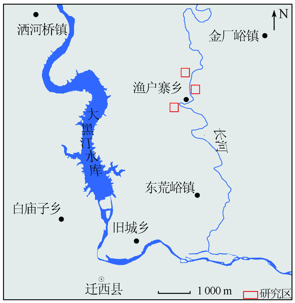
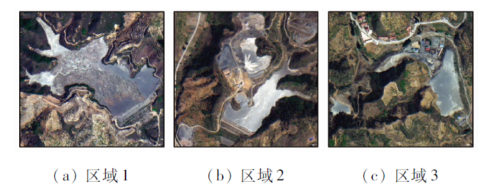
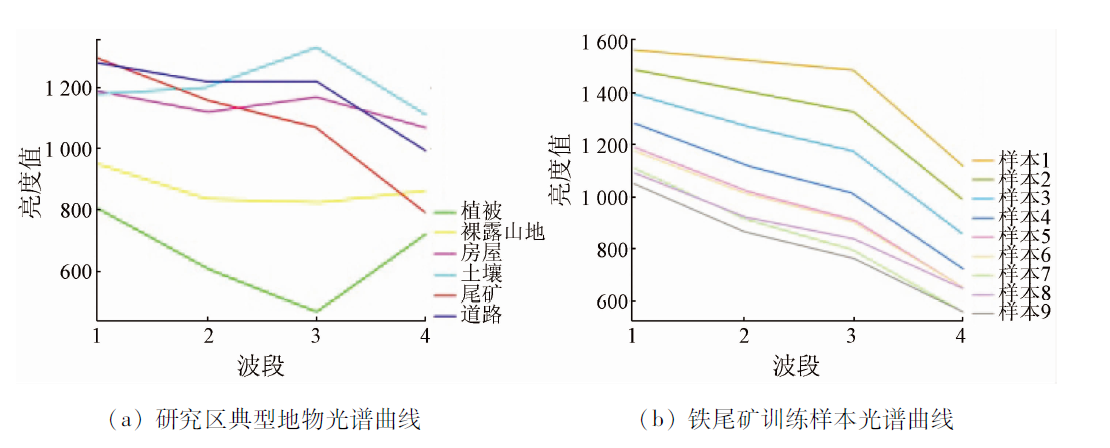
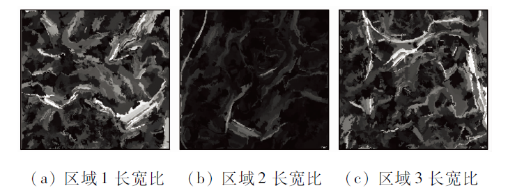
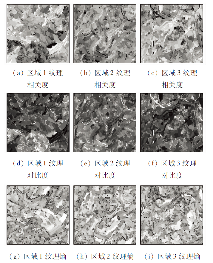
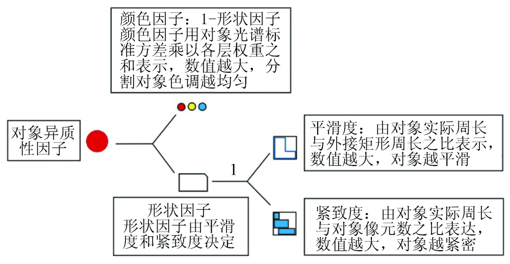
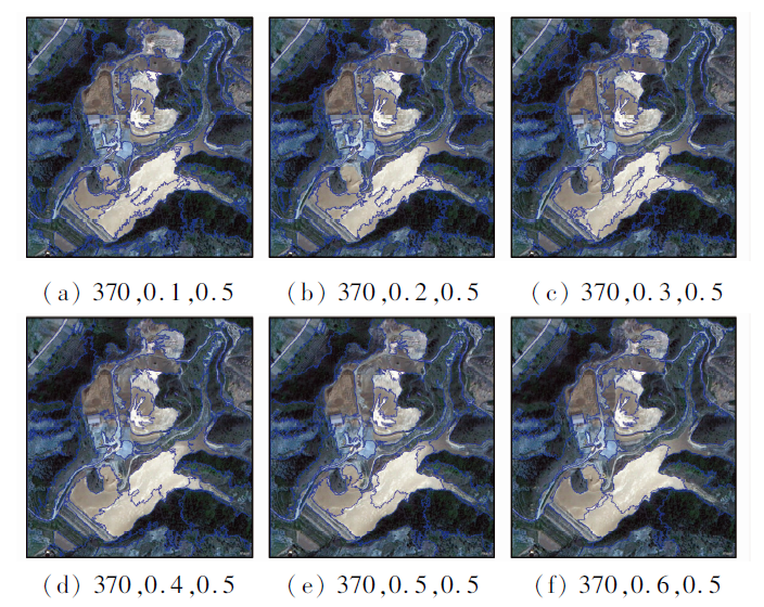
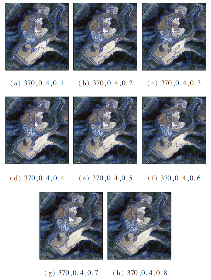
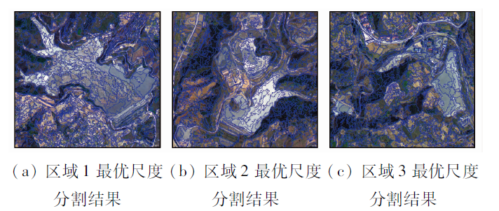
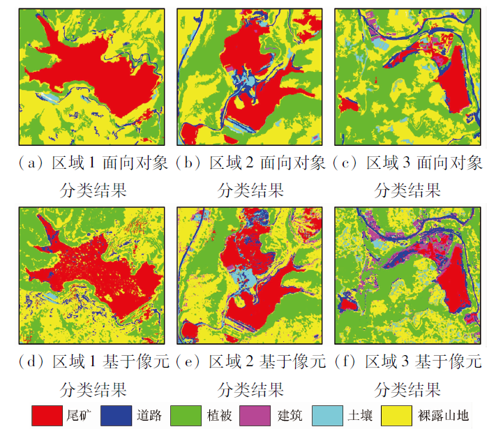
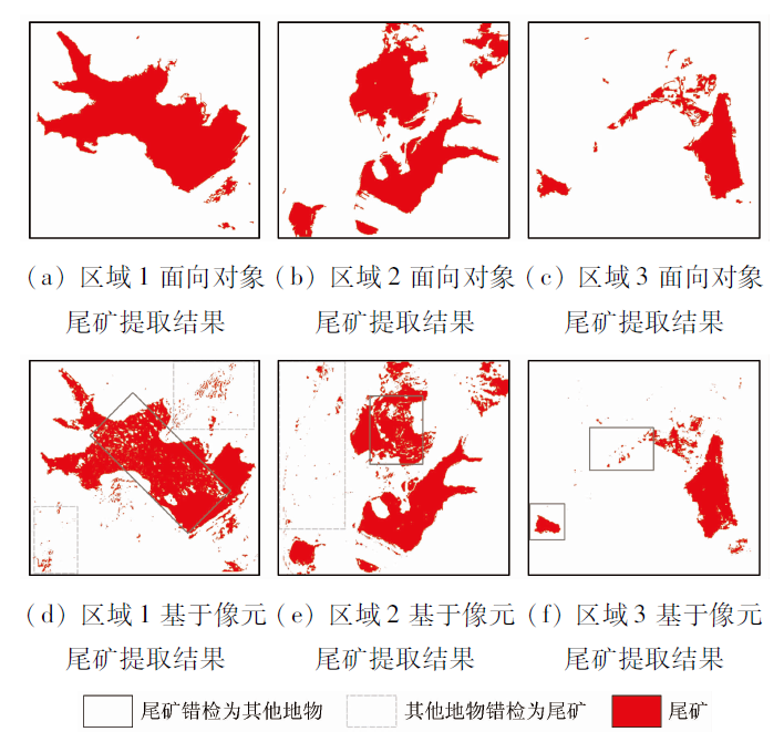
The recognition and extraction of mine tailing information serve as an important step in the dynamic monitoring of the mine environment. The classification of surface features using medium-low spatial resolution images is mostly conducted based on spectral information. However, some roads and tailings have similar spectral reflectance due to the special environment in mining areas. As a result, it is liable to misclassify tailings as roads in the surface feature classification based on spectral information only, which affects the structural integrity and area statistics of tailing ponds. Given this, this paper comprehensively analyzes the spectral, shape-related, and texture characteristics of iron mine tailings in the Qianxi area, Hebei Province based on high spatial resolution images obtained from the Beijing-2 satellite and proposes an object-oriented classification method based on multiple features. The steps of the method are as follows. Firstly, perform multi-scale segmentation of Beijing-2 images and the reflectance and take the spectral differences of surface features in each band as the spectral characteristic values of surface features. Secondly, extract the values of length-to-width ratio of objects using a covariance matrix and object boundaries and take them as the characteristic values of surface feature shapes. Then, calculate the gray-level co-occurrence matrix using principal component bands, and select the contrast, correlation, and entropy values that can effectively distinguish the texture characteristics between tailings and other surface features as the texture characteristic values of remote sensing images. Finally, conduct object-oriented classification and precision assessment using the nearest neighbor method according to the characteristic information of surface features. The results indicate that the object-oriented classification method can effectively avoid the misclassification of the roads in tailing ponds and thus provide a research basis for the implementation of large-scope and high-precision identification and dynamic monitoring of mine tailings.
范莹琳, 娄德波, 张长青, 魏英娟, 贾福东. 基于面向对象的铁尾矿信息提取技术研究——以迁西地区北京二号遥感影像为例[J]. 自然资源遥感, 2021, 33(4): 153-161.
FAN Yinglin, LOU Debo, ZHANG Changqing, WEI Yingjuan, JIA Fudong. Information extraction technologies of iron mine tailings based on object-oriented classification: A case study of Beijing-2 remote sensing images of the Qianxi Area, Hebei Province. Remote Sensing for Natural Resources, 2021, 33(4): 153-161.
Bian Z F, Miao X X, Lei S G, et al. The challenges of reusing mining and mineral-processing wastes[J]. Science, 2012,337(6095):702-703.
doi: 10.1126/science.1224757
Wang H J, Wang Y J, Li W C, et al. The report of mineral resources saving and comprehensive utilization in China(2019)[J]. Natural Resource Economics of China, 2020,33(2):2.
[3]
Liu R Z, Liu J, Zhang Z J, et al. Accidental water pollution risk analysis of mine tailings ponds in guanting reservoir watershed,Zhangjiakou City,China[J]. International Journal of Environmental Research and Public Health, 2015,12(12):15269-15284.
doi: 10.3390/ijerph121214983
Hao L N, Zhang Z, He W X, et al. Tailings reservoir recognition factors of the high resolution remote sensing image in southeastern Hubei[J]. Remote Sensing for Land and Resources, 2012,24(3):154-158.doi: 10.6046/gtzyyg.2012.03.27.
doi: 10.6046/gtzyyg.2012.03.27
Wang J H, Bai Y, Liu Y Q. Spectrum characteristic and information extraction of the iron tailings with high resolution remote sensing[J]. Scientific and Technological Management of Land and Resources, 2015,32(1):79-85.
[6]
Ma B D, Chen Y T, Zhang S, et al. Remote sensing extraction method of tailings ponds in ultra-low-grade iron mining area based on spectral characteristics and texture entropy[J]. Entropy, 2018,20(5):345-354.
doi: 10.3390/e20050345
Li J, Wu C P, Liu M H, et al. Detection of shape characteristics of kiwifruit based on hyperspectral imaging technology[J]. Spectroscopy and Spectral Analysis, 2020,40(8):2564-2570.
Hu M, Teng W T, Wang X H, et al. Facial expression recognition based on local texture and shape features[J]. Journal of Electronics and Information technology, 2012,40(6):1338-1344.
Song X Y, Shan X J. Identification of urban buildings using high resolution satellite images[J]. Journal of Xinjiang University (Natural Science), 2002(s1):108-111.
Huang H P. Scale issues in object-oriented image analysis[D]. Beijing:Graduate University of Chinese Academy of Sciences (Institute of Remote Sensing Applications), 2003.
Dai J J, Wu Y N, Wang D H, et al. Object-oriented classification for the extraction of remote sensing information in rare earth mining areas[J]. Acta Geoscience Sinica, 2018,39(1):111-118.
Zhang Y B, Liu J L, Ji J, et al. Texture analysis and object-oriented classification of open limestone mines[J]. Geology and Exploration, 2018,54(2):348-357.
Shen Z F, Luo J C, Hu X D, et al. A mean shift multi-scale segmentation for high-resolution remote sensing images[J]. Geomatics and Information Science of Wuhan University, 2010,35(3):313-316.
Wang S J, Feng W, Meng D, et al. Rapid information extraction of the iron tailing pile using object-oriented classification technique[J]. Remote Sensing Information, 2012(2):103-107.
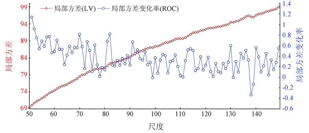
Mao N, Liu H P, Liu X P, et al. Optimal scale selection for multi-scale segmentation based on RMNE method[J]. Remote Sensing of Land and Resources, 2019,31(2):10-16.doi: 10.6046/gtzyyg.2019.02.02.
doi: 10.6046/gtzyyg.2019.02.02
Chen Y Y, Ming D P, Xu L, et al. An overview of quantitative experimental methods for segmentation evaluation of high spatial remote sensing images[J]. Journal of Geo-Information Science, 2017,19(6):818-830.
Sun Y J, Tong Q X, Qin Q M. The object-oriented method for wetland information extraction.[J]Remote Sensing of Land and Resources, 2008(1):79-82,108.doi: 10.6046/gtzyyg.2008.01.18.
doi: 10.6046/gtzyyg.2008.01.18
Li Z F, Zhu G C, Dong T F, et al. Application of GLCM-Based texture features to remote sensing image classification[J]. Geology and Prospecting, 2011,47(3):456-461.
[20]
Haralick R M. Textural features for image classification[J]. IEEE Transactions on Systems, 1973,3(6):610-621.
[21]
Haralick R M. Statistical and structural approaches to texture[J]. Proceedings of the IEEE, 1973,67(5):786-805.
doi: 10.1109/PROC.1979.11328
[22]
Blaschke T, Hay G J, Kelly M, et al. Geographic object-based image analysis:Towards a new paradigm[J]. ISPRS Journal of Photogrammetry and Remote Sensing, 2014(87):180-191.
[23]
朱彦光. 基于词包模型的地表矿山要素遥感信息提取方法研究[D]. 长沙:湖南师范大学, 2016.
Zhu Y G. Remote sensing information extraction for elements of surface mine based on Bag-of-Word model[D]. Changsha:Hunan Normal University, 2016.
[24]
Baatz M, Schape A. Multi-resolution segmentation:An optimization approach for high quality multiscale image segmentation[P].Angewandte Geogr. Information averarbeitung, 2000.
Zhong Z, Zhu M L, Zhang C, et al. Research on nearest neighbors classification techniques[J]. Journal of Frontiers of Computer Science and Technology, 2011,5(5):467-473.
 2021, Vol. 33
  ), 娄德波1, 张长青1, 魏英娟3, 贾福东1