Classification and change analysis of the substrate of the Yongle Atoll in the Xisha Islands based on Landsat8 remote sensing data
LI Tianchi1(), WANG Daoru2, ZHAO Liang1(), FAN Renfu2
1. College of Marine and Environmental Sciences, Tianjin University of Science and Technology, Tianjin 300457, China 2. Hainan Academy of Ocean and Fisheries Sciences, Haikou 571126, China
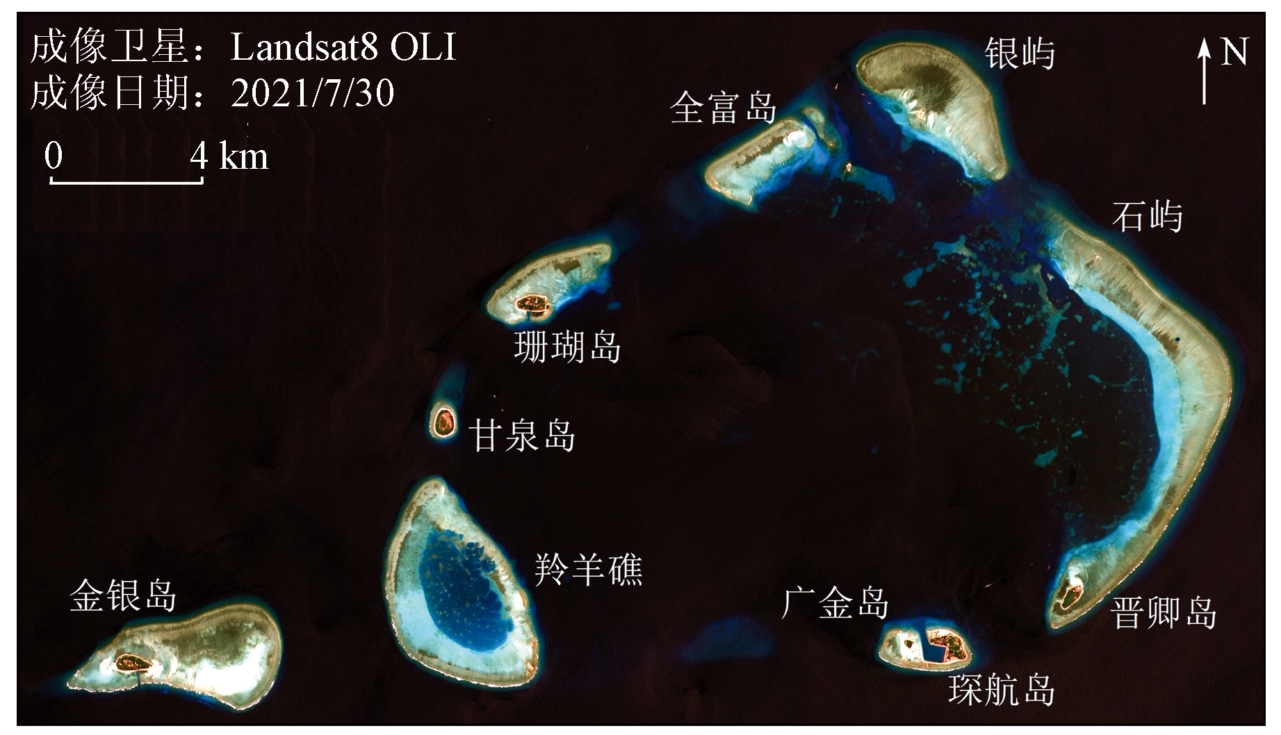
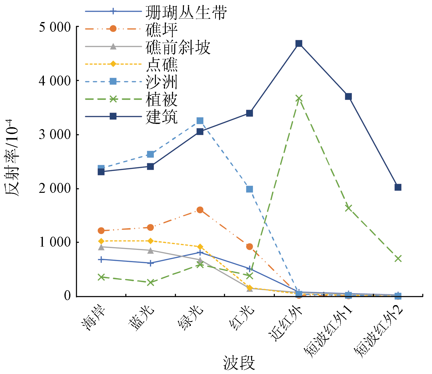
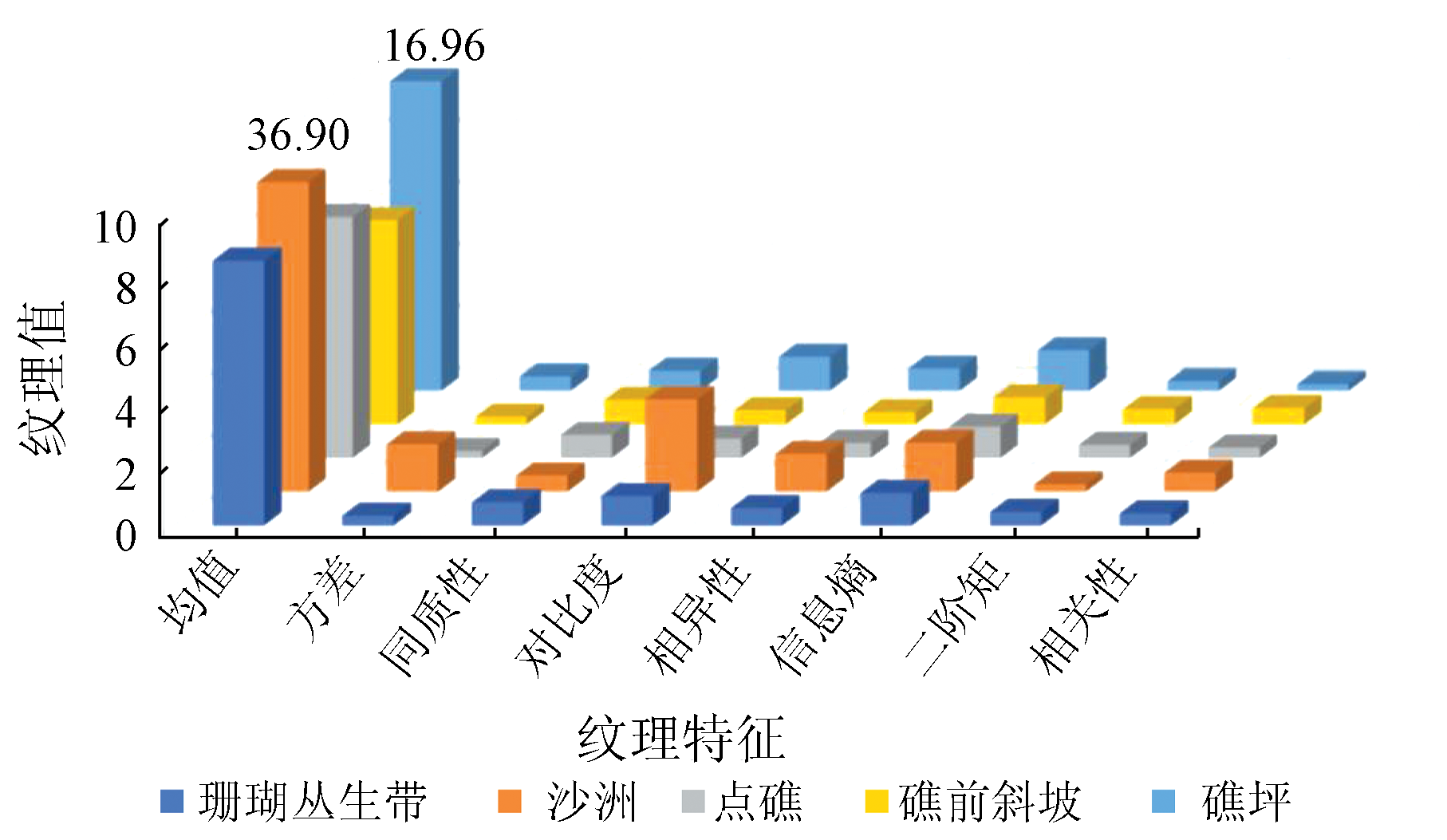
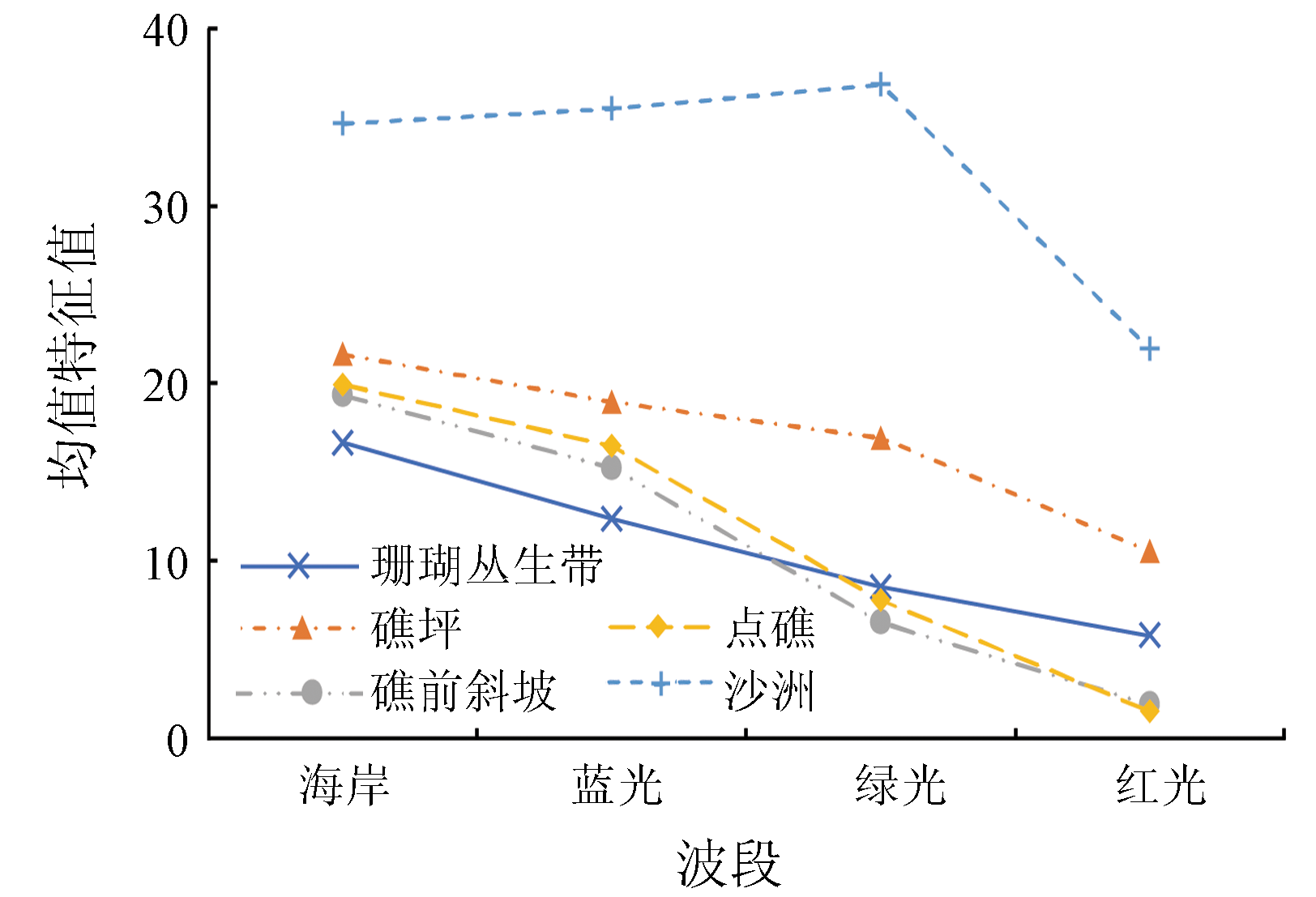
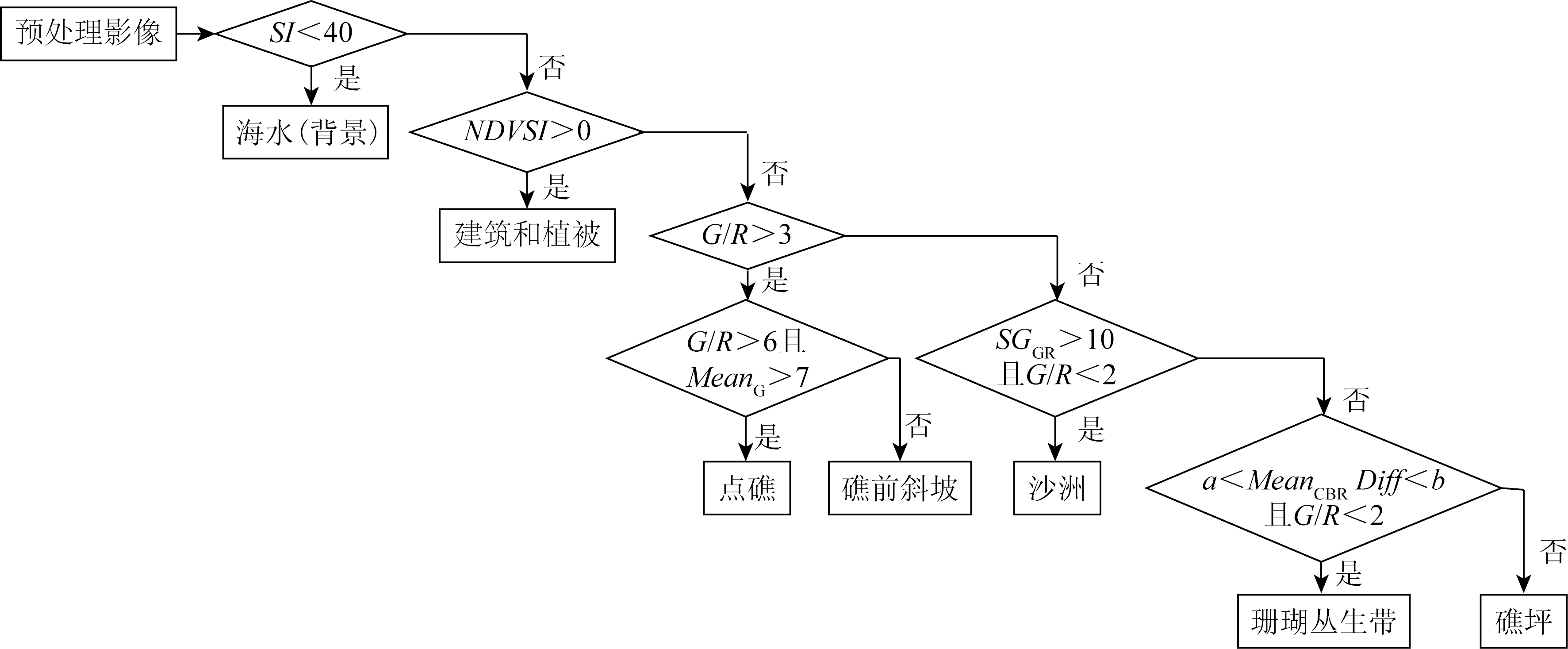
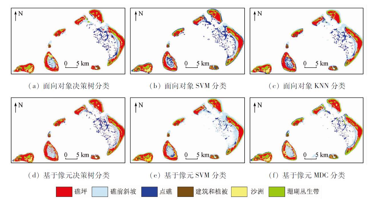
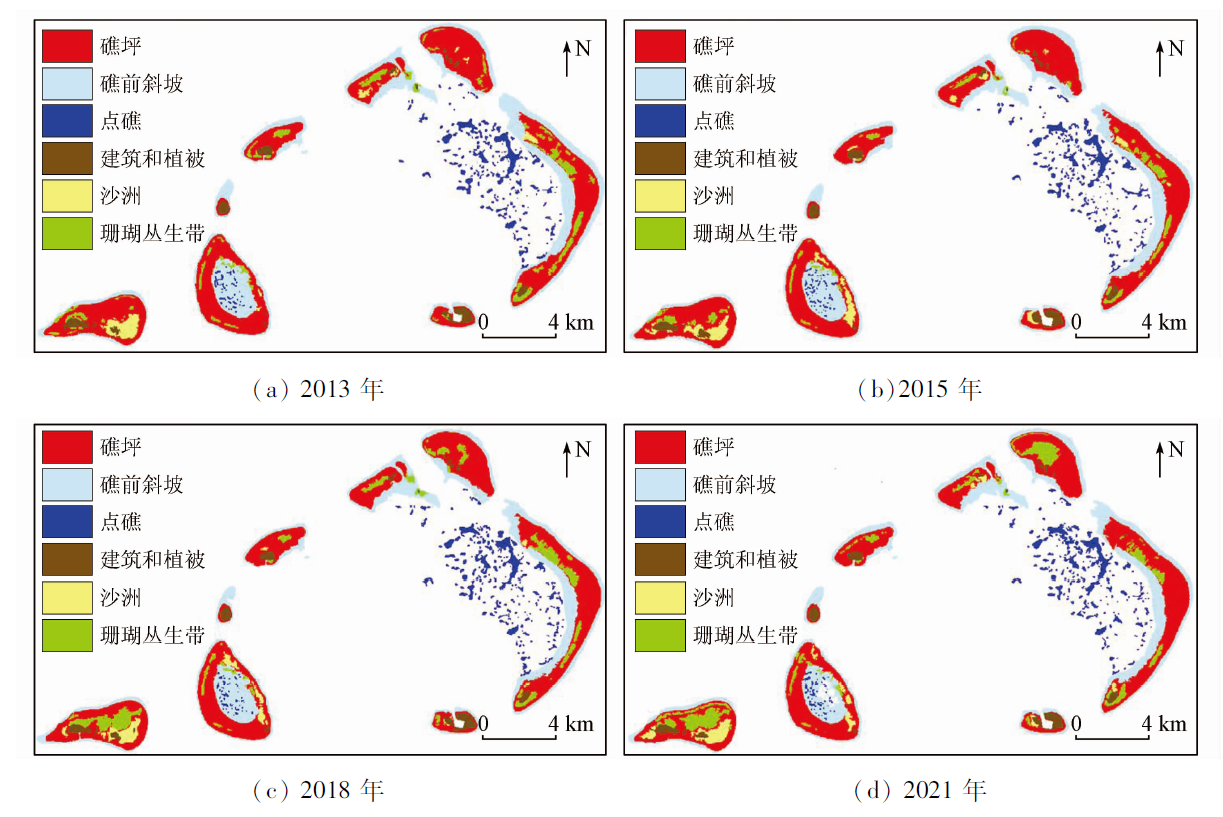
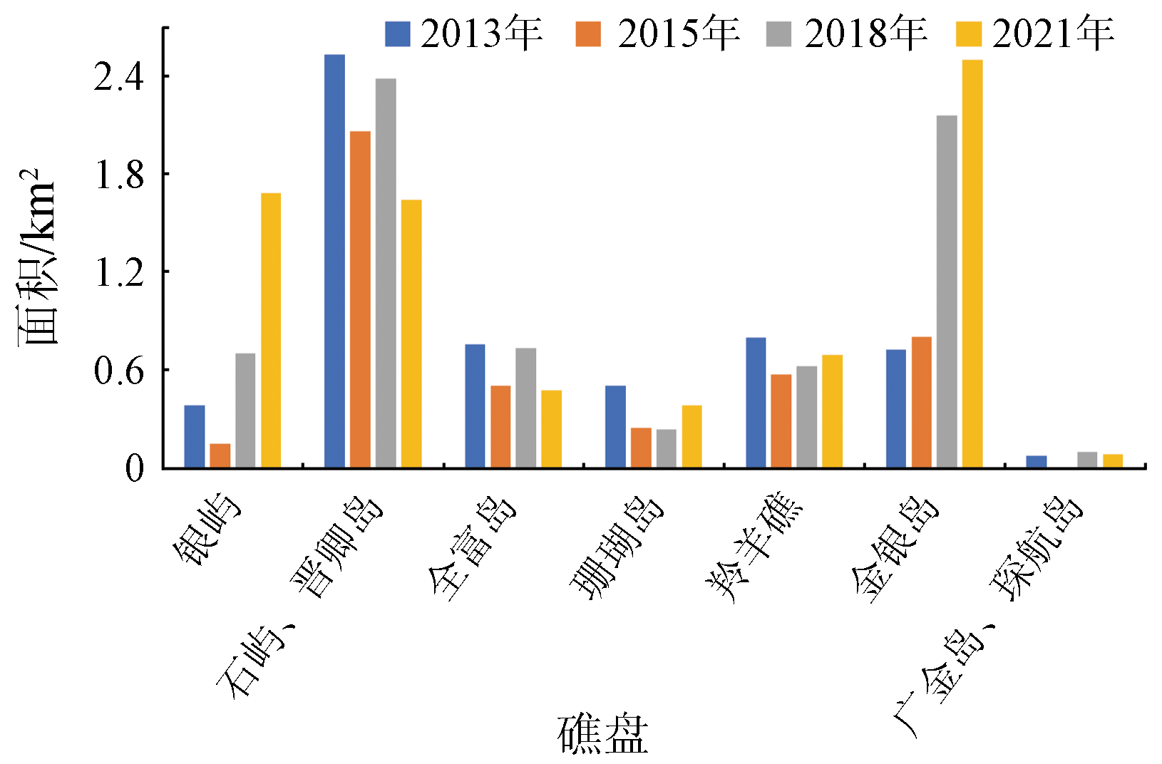
In view of the drastic changes in the ocean-atmosphere environment, the accurate and efficient identification of coral reef substrate information is essential for the dynamic monitoring of coral reefs. Based on the Landsat8 satellite data of the Yongle Atoll in the Xisha Islands of four periods during 2013—2021, this study proposed a decision tree classification model using spectral and texture indices according to the spectral and texture differences between different substrates. Then, the coral information was extracted using object-oriented and pixel-based classification methods. In addition, the changes in the substrate of the Yongle Atoll were quantitatively analyzed. The results are as follows: ① The results of the object-oriented classification are superior to those of pixel-based classification overall. Moreover, the decision tree classification results yielded Kappa coefficients of 0.63~0.68, with classification accuracy about 7~10 percentage points higher than that of conventional supervised classification; ② Coral thickets are mostly distributed in the central, weakly-hydrodynamic parts of islands and reefs. The corals in the Yinyu Reef and the Jinyin Island exhibit a planar distribution pattern, while those in other islands and reefs mostly show a zonal distribution pattern; ③ The areas of coral thickets and sandbanks in the Yongle Atoll changed significantly overall. Although the total area of coral thickets increased by 1.689 km2, the coral thickets in the Shiyu, Jinqing, Quanfu, and Shanhu islands and the Lingyang reef were severely degraded, with areas decreasing by 0.107~0.892 km2. This study verified that the substrate index established using medium spatial resolution images is reliable and can be applied to remote sensing information extraction of corals. Therefore, this study will provide technical support for the investigation and scientific management of coral reef resources.
李天驰, 王道儒, 赵亮, 凡仁福. 基于Landsat8遥感数据的西沙群岛永乐环礁底质分类与变化分析[J]. 自然资源遥感, 2023, 35(2): 70-79.
LI Tianchi, WANG Daoru, ZHAO Liang, FAN Renfu. Classification and change analysis of the substrate of the Yongle Atoll in the Xisha Islands based on Landsat8 remote sensing data. Remote Sensing for Natural Resources, 2023, 35(2): 70-79.
Zhao M X, Yu K F, Zhang Q M. Review on coral reefs biodiversity and ecological function[J]. Acta Ecologica Sinica, 2006, 26(1):186-194.
[2]
Couce E, Ridgwell A, Hendy E J. Environmental controls on the global distribution of shallow-water coral reefs[J]. Journal of Biogeography, 2012, 39(8):1508-1523.
doi: 10.1111/jbi.2012.39.issue-8
Yu K F. Coral reefs in the South China Sea:Their response to and records on past environmental changes[J]. Science China Earth Science, 2012, 42(8):1160-1172.
Zhang J J, Su Z F, Wang W Y. A review of geographical information research on resources and environment of the South China Sea region[J]. Progress in Geography, 2018, 37(11):1443-1453.
doi: 10.18306/dlkxjz.2018.11.001
Li Y C, Chen S Q, Zheng X Q, et al. Analysis of the change of hermatypic corals in Yongxing Island and Qilianyu Island in nearly a decade[J]. Haiyang Xuebao, 2018, 40(8):97-109.
Huang R Y, Yu K F, Wang Y H, et al. Progress of the study on coral reef remote sensing[J]. Journal of Remote Sensing, 2019, 23(6):1091-1112.
[9]
da Silveira C B L Strenzel G M R, Maida M, et al. Coral reef mapping with remote sensing and machine learning:A nurture and nature analysis in marine protected areas[J]. Remote Sensing, 2021, 13(15):2907-2931.
doi: 10.3390/rs13152907
Pang J Z, Ren G B, Shi Q, et al. Analysis of coral reef bleaching in Yongle Islands of Xisha from 2005 to 2018 based on sediment types change monitoring[J]. Marine Sciences, 2021, 45(6):92-106.
Zuo X L, Su F Z, Zhao H T, et al. Development of a geomorphic classification scheme for coral reefs in the South China Sea based on high-resolution satellite images[J]. Progress in Geography, 2018, 37(11):1463-1472.
doi: 10.18306/dlkxjz.2018.11.003
Li J Q, Bai A J, Cai Q B. Climate change characteristics of the Xisha Islands and Weizhou Island in China and the comparison with the coastal land[J]. Tropical Geography, 2018, 38(1):72-81.
Tao S C, Zhang H L, Yu K F, et al. Annual resolution sea surface temperature reconstructed quantitatively by porites coral growth rate in the Xishaqundao Islands during the past five centuries and their environmental significance[J]. Quaternary Sciences, 2021, 41(2):411-423.
Li X M, Ma Y, Lyu X X. Establishing a remote sensing classification system and interpretation marks for the coral islands and reefs in the South China Sea[J]. Marine Sciences, 2021, 45(5):23-30.
Dong J, Ren G B, Hu Y B, et al. Construction and classification of coral reef geomorphic unit system based on high-resolution remote sensing:Using 8-band Worldview-2 image as an example[J]. Journal of Tropical Oceanography, 2020, 39(4):116-129.
[17]
Nimalan K, Thanikachalam M, Usha T. Spectral characteristics of coral reef benthic compositions in gulf of Mannar[J]. Journal of Earth System Science, 2021, 130(1):1-7.
doi: 10.1007/s12040-020-01500-2
Xu J P, Li F, Meng Q H, et al. The analysis of spectral separability of different coral reef benthos and the influence of pigments on coral spectra based on in situ data[J]. Spectroscopy and Spectral Analysis, 2019, 39(8):2462-2469.
[19]
Zeng K, Xu Z, Yang Y, et al. In situ hyperspectral characteristics and the discriminative ability of remote sensing to coral species in the South China Sea[J]. GIScience and Remote Sensing, 2022, 59(1):272-294.
doi: 10.1080/15481603.2022.2026641
[20]
Haralick R M, Shanmugam K, Dinstein I H. Textural features for image classification[J]. IEEE Transactions on Systems,Man,and Cybernetics, 1973, SMC-3(6):610-621.
doi: 10.1109/TSMC.1973.4309314
Pan C, Du P J, Zhang H R. Decision tree classification and its application in processing of remote sensing images[J]. Science of Surveying and Mapping, 2008, 33(1):208-211,253.
Wan J X, Ren G B, Ma Y. Study on substrate changes of Zhaoshu reef flat based on WorldView-2 and GF-2 remote sensing images[J]. Marine Sciences, 2019, 43(10):43-54.
Xu H Q. A study on information extraction of water body with the modified normalized difference water Index(MNDWI)[J]. Joural of Remote Sensing, 2005, 9(5):589-595.
[25]
Curran P J. Multispectral Remote sensing for the estimation of green leaf area index[J]. Philosophical Transactions of the Royal Society of London.Series A,Mathematical and Physical Sciences, 1983, 309(1508):257-270.
[26]
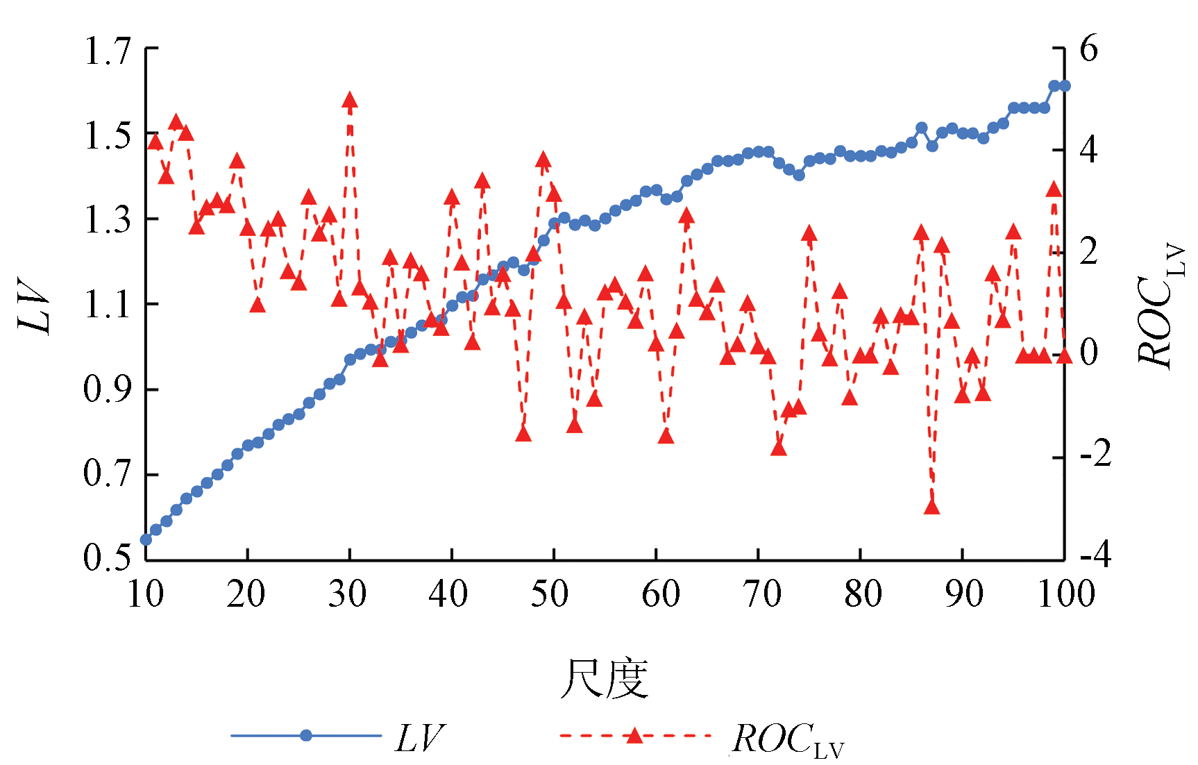
Drǎguţ L, Tiede D, Levick S R. ESP:A tool to estimate scale parameter for multiresolution image segmentation of remotely sensed data[J]. International Journal of Geographical Information Science, 2010, 24(6):859-871.
doi: 10.1080/13658810903174803
[27]
赵英时. 遥感应用分析原理与方法[M]. 北京: 科学出版社, 2003:191-193.
Zhao Y S. Principles and methods of remote sensing application analysis[M]. Beijing: Science Press, 2003:191-193.
Pei H, Sun T J, Wang X Y. Object-oriented land use/cover classification based on texture features of Landsat8 OLI image[J]. Transactions of the Chinese Society of Agricultural Engineering, 2018, 34(2):248-255.
[29]
Lu C, Liu J, Jia M, et al. Dynamic analysis of mangrove forests based on an optimal segmentation scale model and multi-seasonal images in Quanzhou Bay,China[J]. Remote Sensing, 2018, 10(12):2020-2042.
doi: 10.3390/rs10122020
[30]
Espindola G M, Câmara G, Reis I A, et al. Parameter selection for region-growing image segmentation algorithms using spatial autocorrelation[J]. International Journal of Remote Sensing, 2006, 27(14):3035-3040.
doi: 10.1080/01431160600617194
 2023, Vol. 35
  ), 王道儒2, 赵亮1(