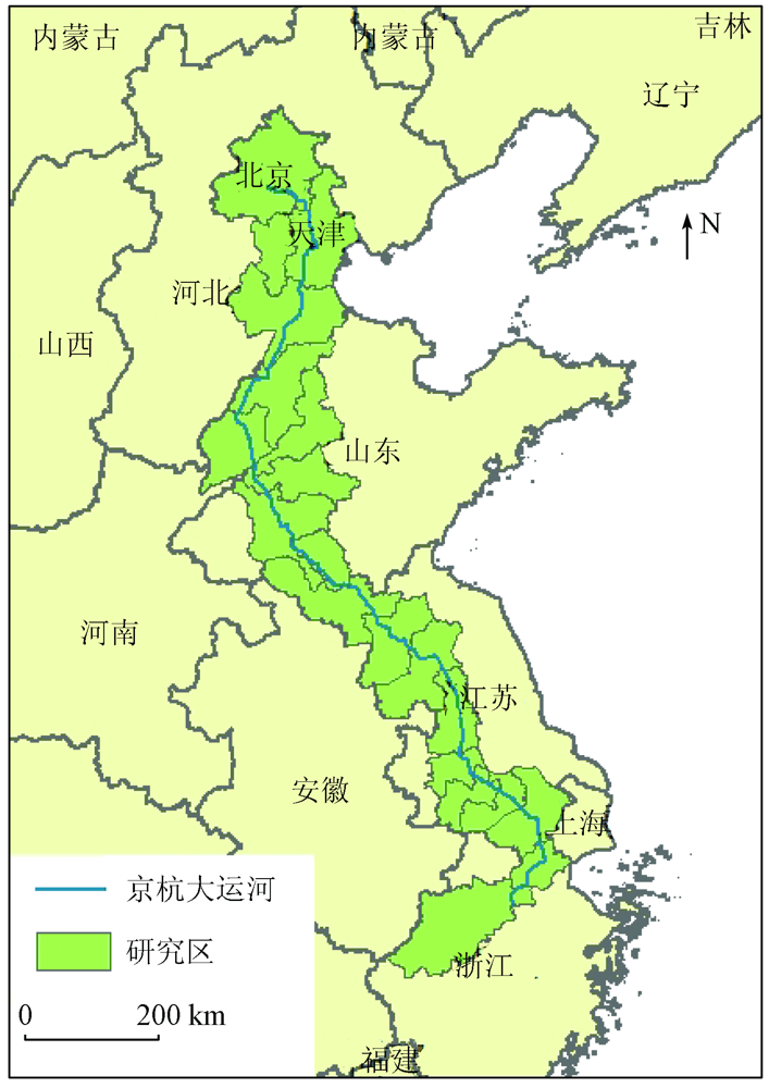
Coupling and coordination relationships between urbanization and ecological environment along the Beijing-Hangzhou Grand Canal
MENG Dan1,2,3(), LIU Lingtong1,2,3, GONG Huili1,2,3, LI Xiaojuan1,2,3, JIANG Bowu1,2,3
1. College of Resources Environment and Tourism, Capital Normal University, Beijing 100048, China 2. Base of the State Key Laboratory of Urban Environmental Process and Digital Modeling, Beijing 100048, China 3. Beijing Laboratory of Water Resources Security, Beijing 100048, China
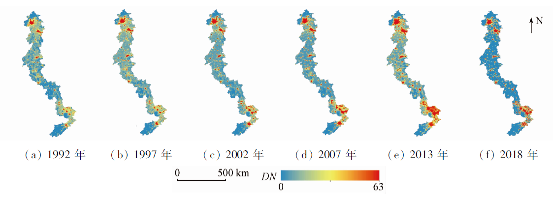
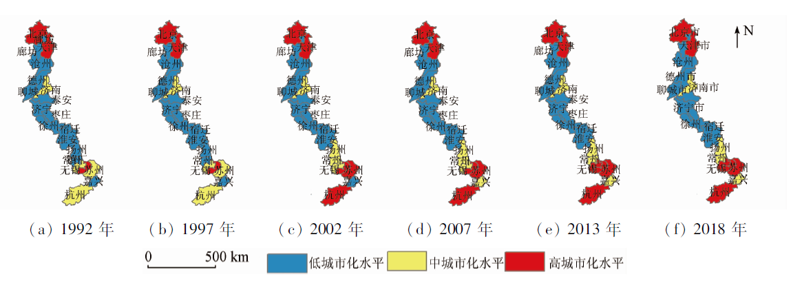
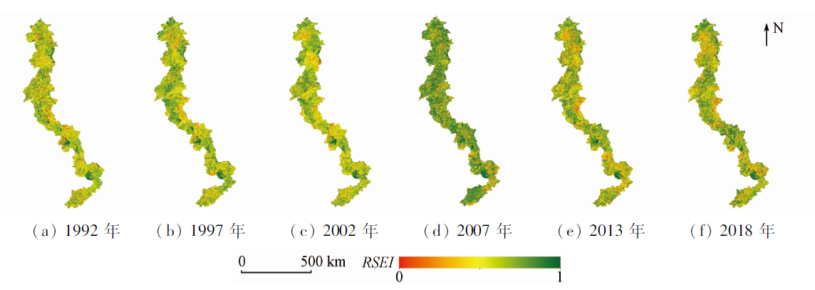
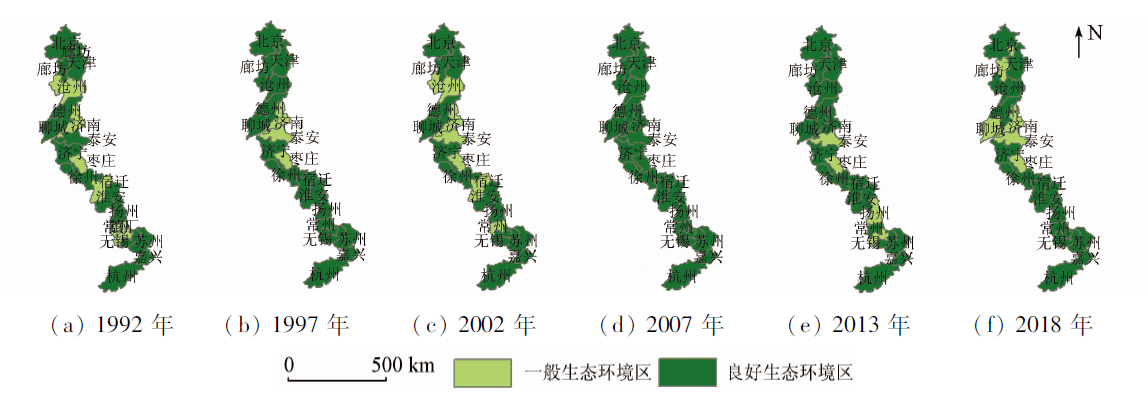
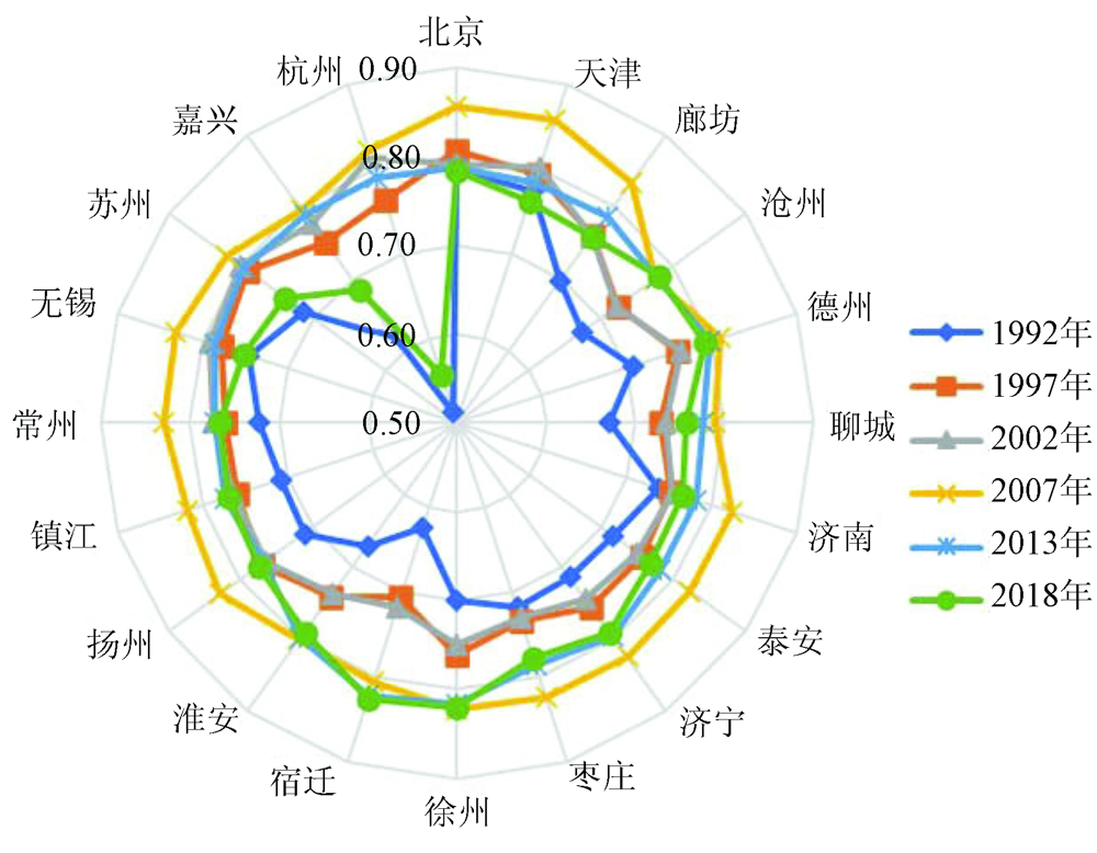
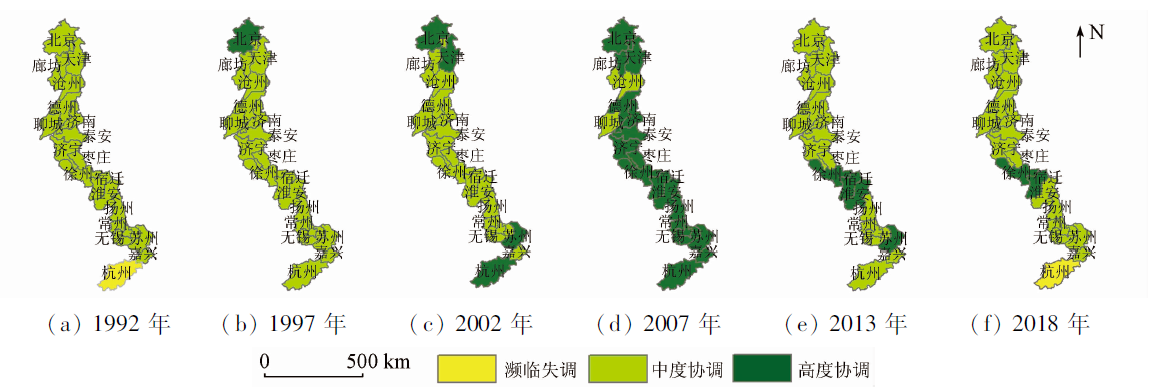
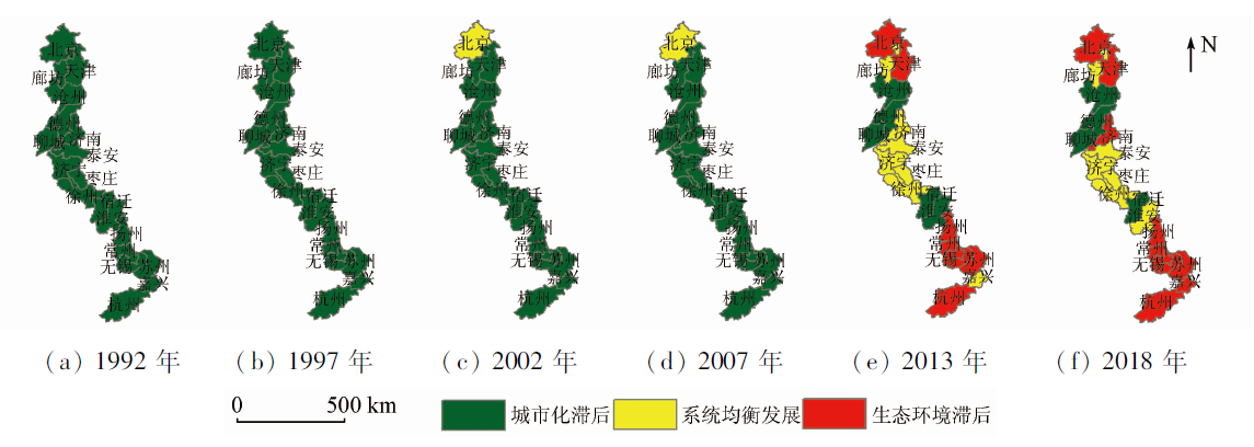
This paper aims to study the coupling and coordination relationships between the urbanization and ecological environment in the areas along the Beijing-Hangzhou Grand Canal from 1992 to 2018. To this end, it builds the remote sensing ecological index (RSEI) based on Landsat data to characterize the quality of the ecological environment and establishes the compounded night light index (CNLI) based on DMSP/OLS and NPP/VIIRS nighttime light (NTL) data to characterize the urbanization level. Meanwhile, it determines the coordinated development pattern between the urbanization and ecological environment in the area by applying a coupling and coordination degree model and its classification principles. The results are as follows. ① The urban development level along the Beijing-Hangzhou Grand Canal is characterized by spatial imbalance. It is high in the southern and northern areas but low in the middle areas. During 1992—2018, the number of cities with a high urbanization level increased year by year. The periods from 1992 to 2002, from 2002 to 2013, and from 2013 to 2018 witnessed the slow development, the accelerated development, and the steady improvement of urbanization, respectively. ② During 1992—2018, the RSEI values were all greater than 0.4, indicating a high-quality ecological environment. The ecological environment in the areas along the canal was relatively stable from 1992 to 2002, improved from 2002 to 2007, and deteriorated from 2007 to 2018 to a certain degree. ③ During 1992—2018, the coupling and coordination degree between urbanization and the ecological environment increased first and then decreased. In terms of the coordinated development type, urbanization lagged behind the ecological environment firstly and then the latter gradually lagged behind the former, indicating that the quality of the ecological environment needs further improving. That is, it is necessary to strengthen the protection of the ecological environment while developing the economy along the Beijing-Hangzhou Grand Canal.
孟丹, 刘玲童, 宫辉力, 李小娟, 蒋博武. 京杭大运河沿线地区城市化与生态环境耦合协调关系研究[J]. 自然资源遥感, 2021, 33(4): 162-172.
MENG Dan, LIU Lingtong, GONG Huili, LI Xiaojuan, JIANG Bowu. Coupling and coordination relationships between urbanization and ecological environment along the Beijing-Hangzhou Grand Canal. Remote Sensing for Natural Resources, 2021, 33(4): 162-172.
Wu G H, Wu P F. Research on the influencing factors of China’s resources and environment to urbanization based on computer[J]. Journal of Physics:Conference Series, 2020,1549:022098.
doi: 10.1088/1742-6596/1549/2/022098
Chen X H, Zhou H H. Research hotspots and prospects of urbanization and ecological environment relationship based on visual knowledge mapping[J]. Progress in Geography, 2018,37(9):1171-1185.
Fang N, Zhang Q, Yang D X, et al. Spatial-temporal evolution and coupling coordination between ecological civilization construction and urbanization in Hunan Province[J]. Areal Research and Development, 2020,39(6):59-64.
Hu M. Time Series analysis on the changes of suburban eco-environment and its driving factors:A study case of Jiangning[D]. Nanjing:Nanjing Forestry University, 2017.
Liang L W, Wang Z B, Fang C L, et al. Spatiotemporal differentiation and coordinated development pattern of urbanization and the ecological environment of the Beijing-Tianjin-Hebei urban agglomeration[J]. Acta Ecologica Sinica, 2019,39(4):1212-1225.
[6]
Wang Y F, Geng Q J, Si X H, et al. Coupling and coordination analysis of urbanization,economy and environment of Shandong Province,China[J]. Environment Development and Sustainability, 2020(4):1-19.
Li F T, Zhang G, Jia J P. Analysis on urban expansion and ecological pattern based on geographical condition data:Taking Wuhan as an example[J]. Bulletin of Surveying and Mapping, 2020(11):93-98.
Fang C L, Zhou C H, Gu C L, et al. Theoretical analysis of the interaction coupled between urbanization and eco-environment in mega-city agglomerations[J]. Acta Geographica Sinica, 2016,71(4):531-550.
He Q Y, Li H P, Ouyang X. Analyzing and predicting the urbanization and eco-environment coupling and coordination of the middle reaches of Yangtze River urban agglomerations[J]. Ecological Science, 2020,39(2):182-190.
Wang S J, Fang C L, Wang Y. Quantitative investigation of the interactive coupling relationship between urbanization and eco-environment[J]. Acta Ecologica Sinica, 2015,35(7):2244-2254.
[11]
Li Y F, Li Y, Zhou Y, et al. Investigation of a coupling model of coordination between urbanization and the environment[J]. Journal of Environmental Management, 2012,98:127-133.
doi: 10.1016/j.jenvman.2011.12.025
Liao L H, Dai W Y, Huang H F, et al. Coupling coordination analysis of urbanization and eco-environment system in Jinjiang using Landsat series data and DMSP/OLS nighttime light data[J]. Journal of Fujian Normal University(Natural Science Edition), 2018,34(6):94-103.
[13]
Wang L, Li W J, Wang P F, et al. Spatiotemporal characterization of the urban sprawl and its impacts on urban island in China with DMSP/OLS and MODIS measurements[J]. Theoretical and Applied Climatology, 2019,138(1-2):293-303.
doi: 10.1007/s00704-019-02822-y
Hao R F, Yu D Y, Liu Y P, et al. Use of DMSP/OLS nighttime light data in urbanization monitor[J]. Journal of Beijing Normal University (Natural Science Edition), 2014,50(4):407-413.
Jin P B, Xu P F. A study of urbanization progress and spatial pattern using DMSP/OLS nighttime light data:A case study of Hangzhou City[J]. Remote Sensing for Land and Resources, 2017,29(4):205-213.doi: 10.6046/gtzyyg.2017.04.31.
doi: 10.6046/gtzyyg.2017.04.31
Chen Y B, Zheng Z H, Wu Z F, et al. Review and prospect of application of nighttime light remote sensing data[J]. Progress In Geography, 2019,38(2):205-223.
[17]
Wu Y, Jiang M, Chang Z, et al. Does China’s urban development satisfy Zipf’s Law? A multiscale perspective from the NPP-VIIRS nighttime light data[J]. International Journal of Environmental Research and Public Health, 2020,17(4):1-26.
doi: 10.3390/ijerph17010001
[18]
Liang H D, Guo Z Y, Wu J P, et al. GDP spatialization in Ningbo City based on NPP/VIIRS night-time light and auxiliary data using random forest regression[J]. Advance in Space Research, 2020,65(1):481-493.
doi: 10.1016/j.asr.2019.09.035
[19]
Ma T, Yin Z, Li B L, et al. Quantitative estimation of the velocity of urbanization in China using nighttime luminosity data[J]. Remote Sensing, 2016,8(2):1-13.
doi: 10.3390/rs8010001
Cong K L, Dong C, Bo X Y, et al. Evolution analysis of urban spatiotemporal patterns in Shandong Province based on nighttime light remote sensing[J]. Journal of Geomatics, 2021,46(5):78-82.
Xu M J, Chen L, Liu H J, et al. Pattern and process of urbanization in the Yangtze Delta based on DMSP/OLS data[J]. Remote Sensing for Land and Resources, 2011(3):106-112.doi: 10.6046/gtzyyg.2011.03.19.
doi: 10.6046/gtzyyg.2011.03.19
Xu H Q, Shi T T, Wang M Y, et al. Land cover changes in the Xiong’an New Area and a prediction of ecological response to forthcoming regional planning[J]. Acta Ecologica Sinica, 2017,37(19):6289-6301.
Yang J Y, Wu T, Pan X Y, et al. Ecological quality assessment of Xiongan New Area based on remote sensing ecological index[J]. Chinese Journal of Applied Ecology, 2019,30(1):277-284.
[26]
杨静. 京杭大运河生态环境变迁研究[D]. 南京:南京林业大学, 2012.
Yang J. Time series analysis on the changes of suburban eco-environment and its driving factors:A study case of Jiangning[D]. Nanjing:Nanjing Forestry University, 2012.
[27]
张金池. 京杭大运河生态环境变迁[M]. 北京: 科学出版社, 2012.
Zhang J C. Changes of ecological environment along the Beijing-Hangzhou Grand Canal[M]. Beijing: Science Press, 2012.
Huang J. On escalating the construction of “Grand Canal Economic Belt” to national strategy[J]. Journal of Yangzhou University (Humanities and Social Sciences Edition), 2017(4):16-21.
Wu X. Blue book of China Grand Canal:Annual report on the development of China Grand Canal(2018)[R]. Beijing: Social Sciences Academic Press(CHINA), 2018.
[30]
Li X, Li D, Xu H, et al. Intercalibration between DMSP/OLS and VIIRS night-time light images to evaluate city light dynamics of Syria’s major human settlement during Syrian Civil War[J]. International Journal of Remote Sensing, 2017,38(21):5934-5951.
doi: 10.1080/01431161.2017.1331476
[31]
Zheng Q M, Weng Q H, Wang K. Developing a new cross-sensor calibration model for DMSP-OLS and Suomi-NPP VIIRS night-light imageries[J]. ISPRS Journal of Photogrammetry and Remote Sensing, 2019,153:36-47.
doi: 10.1016/j.isprsjprs.2019.04.019
Chen J, Zhuo L, Shi P J, et al. The study on urbanization process in China based on DMSP/OLS data:Development of a light index for urbanization level estimation[J]. Journal of Remote Sensing, 2003(3):168-175,241.
Zhang J X, Liu Y P. Research on the spatial development of areas along the Beijing-Hangzhou Grand Canal-with the case study of Yangzhou part of Beijing-Hangzhou Canal[J]. Economic Geography, 2008(1):1-5.
Liu H, Di Q B. Analysis on the influence of the first phase of the South-to-North Water Transfer East Route Project on the economic development of cities along the Beijing-Hangzhou Grand Canal evidence based on synthetic control method[J]. Resource Development & Market, 2020,36(11):1185-1191.
Li X Q, Sun D F, Zhang F R. Landscape pattern analysis on change in the fraction of green vegetation based on remotely sensed data in Beijing mountainous area[J]. Journal of Mountain Science, 2003(3):272-280.
Liu Z X, Yan Y. Study on vegetation coverage and dynamic changes in Tianjin by remote sensing method[J]. Urban Geotechnical Investigation & Surveying, 2019(3):115-120.
 2021, Vol. 33
  ), 刘玲童1,2,3, 宫辉力1,2,3, 李小娟1,2,3, 蒋博武1,2,3