GIS-based study on the deployment of video monitoring points for epidemic prevention in the Xishuangbanna border area
LI Yimin1,2(), YANG Yiming1, ZHAO Zhifang1,2,3(), WU Bowen1
1. College of Earth Science, Yunnan University, Kunming 650500, China 2. Yunnan University Research Center of Domestic High-Resolution Satellite Remote Sensing Geological Engineering, Kunming 650500, China 3. Key Laboratory of Sanjiang Metallogeny and Resources Exploration, Ministry of Natural Resources, Kunming 650500, China
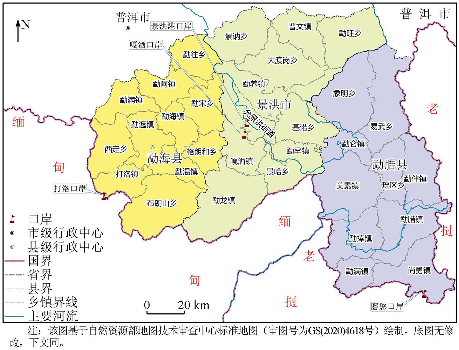
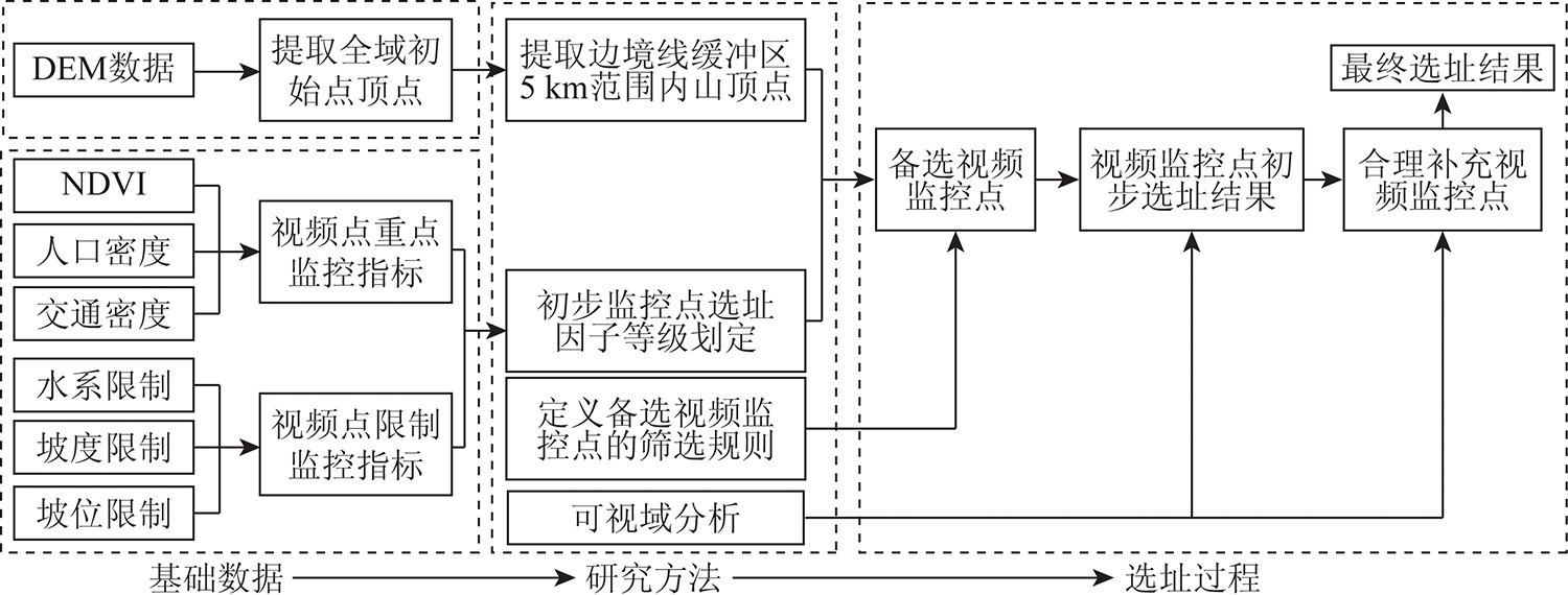
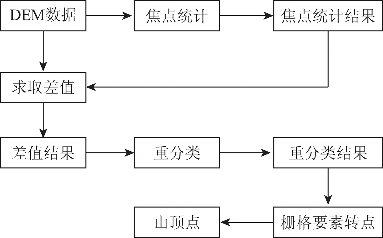
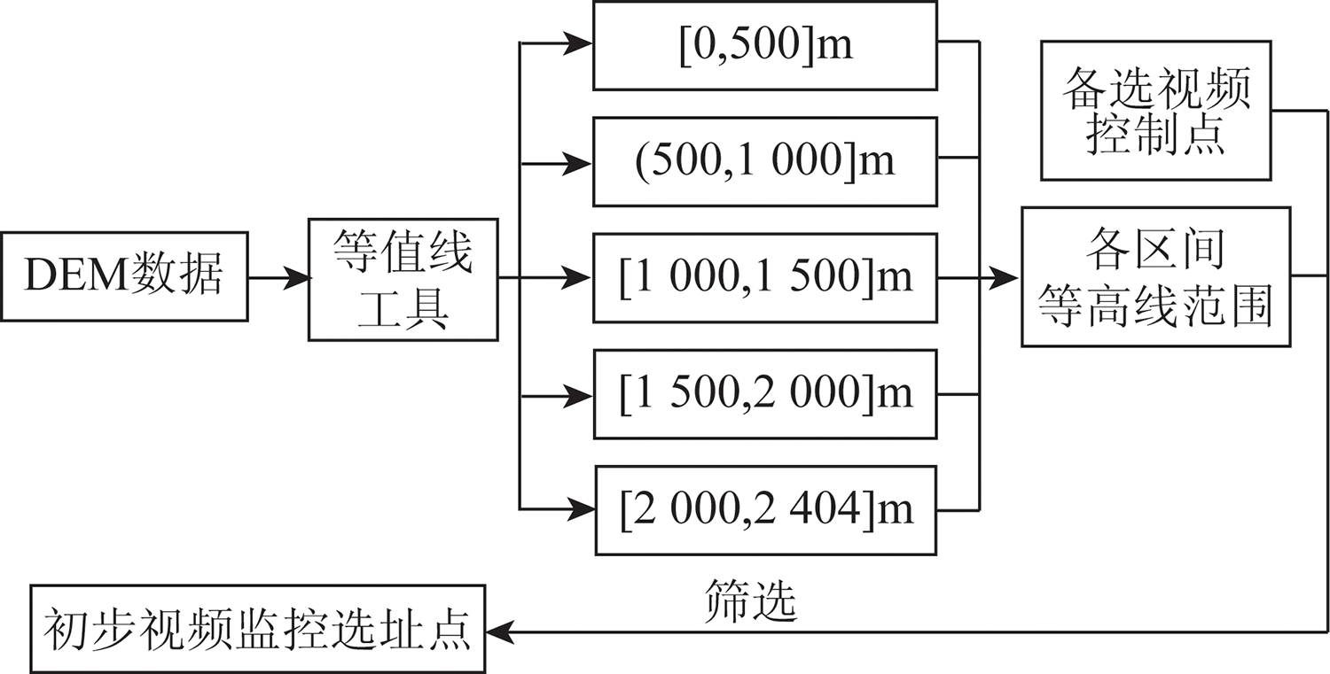
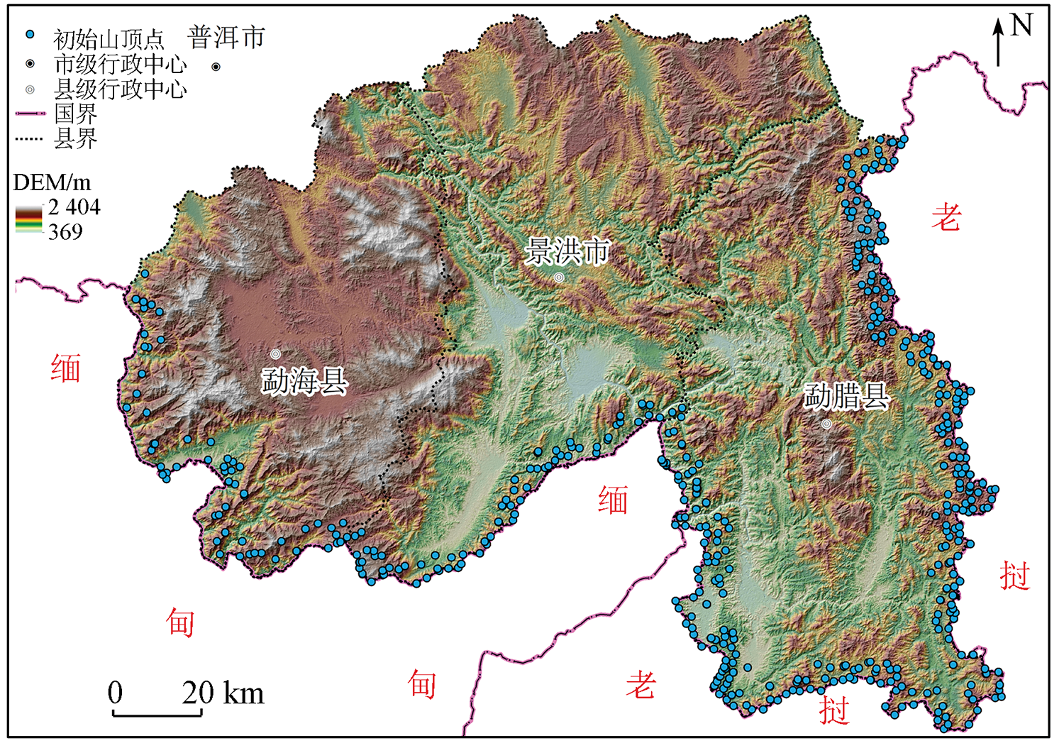
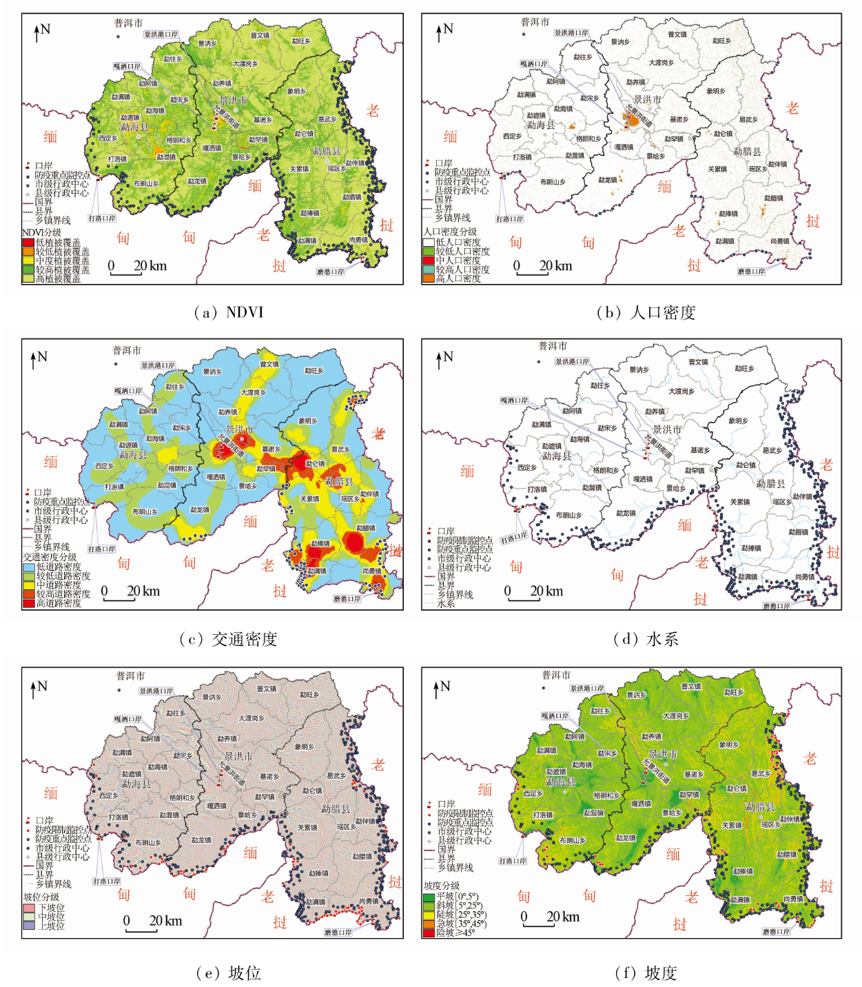
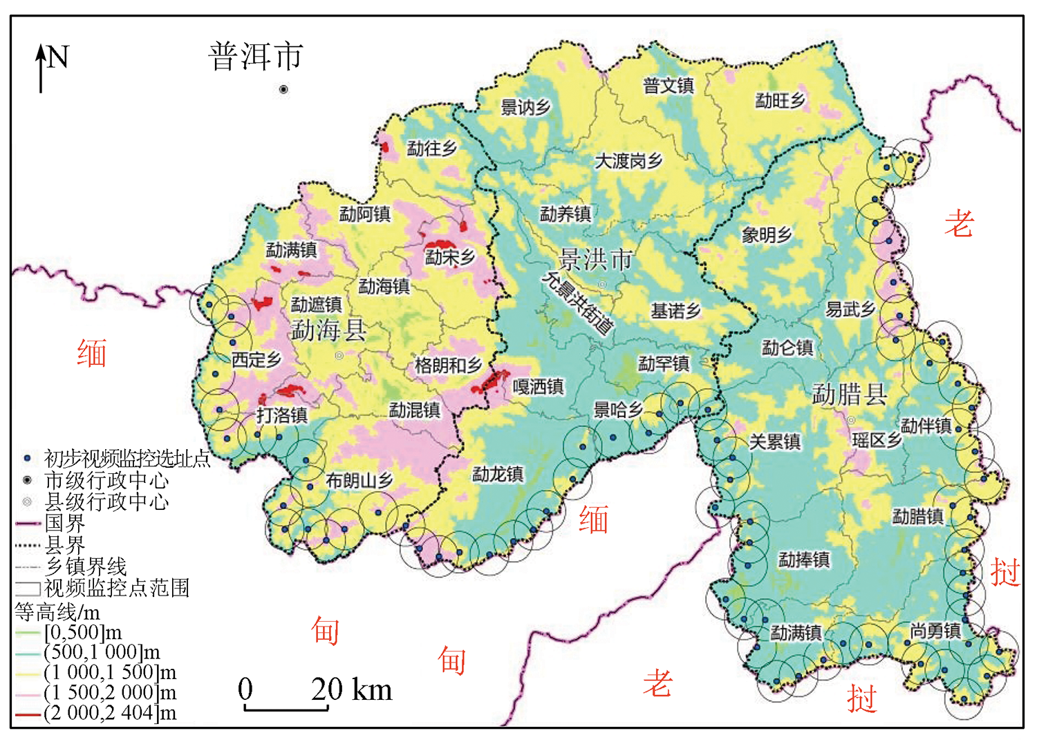
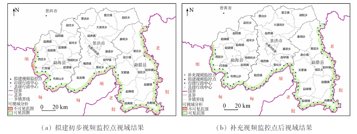
The deployment of video monitoring points for epidemic prevention in border areas is an important measure to deal with emergencies and has great significance for regional public health security. The deployment of video monitoring points mainly focused on cities in the past. Few studies concerned the deployment of video monitoring points based on the characteristics of border areas and emergency response needs. This study constructed a framework for the deployment of video monitoring points for epidemic prevention in the border area of Xishuangbanna Dai Autonomous Prefecture. The suitability and limiting factors of monitoring points were determined for the multi-round selection of monitoring points. More monitoring points were deployed properly in areas with low monitoring efficiency. Finally, the appropriate deployment sites for epidemic prevention monitoring points in Xishuangbanna were determined. The results are as follows. With the video monitoring points for epidemic prevention determined in this study, 93.3% of the area within 5 km of the Xishuangbanna border can be observed. Thus, information on people flow at the border can be comprehensively obtained. Compared with the conventional site selection methods using single-dimensional suitability, mathematical modeling, and algorithms, the proposed deployment method of video monitoring points for border epidemic prevention is more suitable for the actual situation of border areas and can give full play to the overall coordination level of the deployment of monitoring points. Besides, this proposed method avoids the complex application of conventional methods. Therefore, the site selection method of video monitoring points for epidemic prevention proposed in this study provides theoretical reference and technical support for current COVID-19 prevention in border areas, so as to ensure regional public health security and national sustainable development.
李益敏, 杨一铭, 赵志芳, 吴博闻. 基于GIS的西双版纳边境地区防疫视频监控点部署方法[J]. 自然资源遥感, 2022, 34(4): 194-202.
LI Yimin, YANG Yiming, ZHAO Zhifang, WU Bowen. GIS-based study on the deployment of video monitoring points for epidemic prevention in the Xishuangbanna border area. Remote Sensing for Natural Resources, 2022, 34(4): 194-202.
Yang C, Wen C, Xu X K. The COVID-19 impact on population flow of ethnic minority areas[J]. Journal of University of Electronic Science and Technology of China, 2021, 50(6):938-946.
Zhao Z Y, Han Z H, Wei Z, et al. Effect of population flow control in restraining COVID-19 in China[J]. Acta Geographica Sinica, 2022, 77(2):426-442.
doi: 10.11821/dlxb202202011
Liu X L, Yang X. China’s border security governance in the process of opening up:Dilemmas and solutions[J]. Journal of Yunnan Normal University(Humanities and Social Sciences Edition), 2021, 53(5):21-32.
Cheng Y, Liu H, Zhang F F. Cross-border infections in border port areas of China:Take COVID-19 as an example[J]. Geographical Research, 2022, 41(3):851-866.
Zhang C, Liu L. Application of wireless video monitoring system in overseas social security management[J]. Journal of Safety Science and Technology, 2019, 15(s2):58-60.
Zhang J, Liu Y, Han N, et al. Set fire video surveillance site in Community National Forest Park[J]. Journal of Northeast Forestry University, 2009, 37(5):24-27.
[8]
Domenikiotis C, Dalezios N R, Faraslis I. GIS-based weather Radar siting procedure in mountainous terrain[J]. Physics and Chemistry of the Earth, 2010, 35(1):35-42.
Zhang Y Y. Research on location and distribution of multi-objective emergency resources[J]. China Safety Science Journal, 2011, 21(12):153-158.
[11]
O’Hanley J R, Scaparra M P, Garcia S. Probability chains:A general linearization technique for modeling reliability in facility location and related problems[J]. European Journal of Operational Research, 2013, 230(1):63-75.
doi: 10.1016/j.ejor.2013.03.021
Zeng Y R, Wang L, Wang S R. Integrated optimization of location-inventory-delivery problem using hybrid fruit fly optimization algorithm[J]. Operations Research and Managemengt Science, 2022, 31(3):24-30.
Xu J Z, Zhang X Y, Chang X Q, et al. Research on energy storage location and capacity determination based on PV curve and improved genetic algorithm[J]. Acta Energiate Solaris Sinica, 2022, 43(1):263-268.
Luo J X, He D X. Site selection and capacity planning of charging station based on improved coyote optimization algorithm[J]. Application Research of Computers, 2022, 39(3):751-757.
Peng D J, Ye C M, Zhao L W. An improved grasshopper optimization algorithm in application of bi-objective location problem for emergency materials centers[J]. Operations Research and Management Science, 2022, 31(4):14-20.
Hu J L, Tang M G, Luo M L, et al. The extraction of characteristic elements of mountain based on DEM[J]. Journal of Geo-Information Science, 2020, 22(3):422-430.
Xiong L Y, Tang G A, Yang X, et al. Geomorphology-oriented digital terrain analysis:Progress and perspectives[J]. Acta Geographica Sinica, 2021, 76(3):595-611.
Lai C X, Fu W X, Wang H J, et al. Location selection methods of forest fire monitoring points based on forest fire intensity analysis[J]. Bulletin of Surveying and Mapping, 2021(s2):267-270.
Wu H, Huang C, Zhang J H, et al. Deformation monitoring system for high slope in open pit mine with the integration of GNSS and GIS[J]. Geomatics and Information Science of Wuhan University, 2015, 40(5):706-710.
Liu Y M, Fan H J, Gai X H, et al. Estimation accuracy of fractional vegetation cover based on normalized difference vegetation index and UAV hyperspectral images[J]. Remote Sening for Natural Resources, 2021, 33(3):11-17.doi:10.6046/zrzyyg.2020406.
doi: 10.6046/zrzyyg.2020406
Bu Z Q, Bai L B, Zhang J Y. Spatio - temporal evolution of Ningxia urban agglomeration along the Yellow River based on nighttime light remote sensing[J]. Remote Sening for Natural Resources, 2022, 34(1):169-176.doi:10.6046/zrzyyg.2021118.
doi: 10.6046/zrzyyg.2021118
Gao Y, Wang H, Wang P T, et al. Population spatial processing for chinese coastal zones based on census and multiple night light data[J]. Resources Science, 2013, 35(12):2517-2523.
Sun A, Yang Q H, Liu Z, et al. Transportation in the Siliguri Corridor, West Bengal, India:Distribution characteristics,trafficability, and geological environment[J]. Remote Sensing for Natural Resources, 2021, 33(3):138-147.doi:10.6046/zrzyyg.2020421.
doi: 10.6046/zrzyyg.2020421
Yi M H, Wu H, Ye K. Research on geological disaster’s safety evaluation based on geographical conditions information[J]. Science of Surveying and Mapping, 2017, 42(8):40-43.
Yu F, Wang D X, Shi X X, et al. Regeneration rules of three dominant tree species in a pine oak mixed forest under different ecological conditions in the Qinling mountains[J]. Acta Botanica Boreali-Occidentalia Sinica, 2013, 33(5):1020-1026.
Zhang Y H, An Y L, Ma L R, et al. Land use change of slope I and in Karst mountainous regions, Guizhou Province during 1960—2010[J]. Progress in Geography, 2012, 31(7):878-884.
 2022, Vol. 34
  ), 杨一铭1, 赵志芳1,2,3(