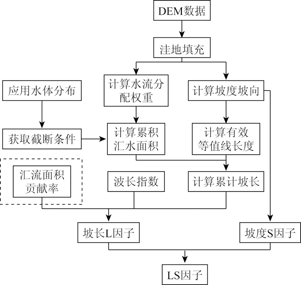
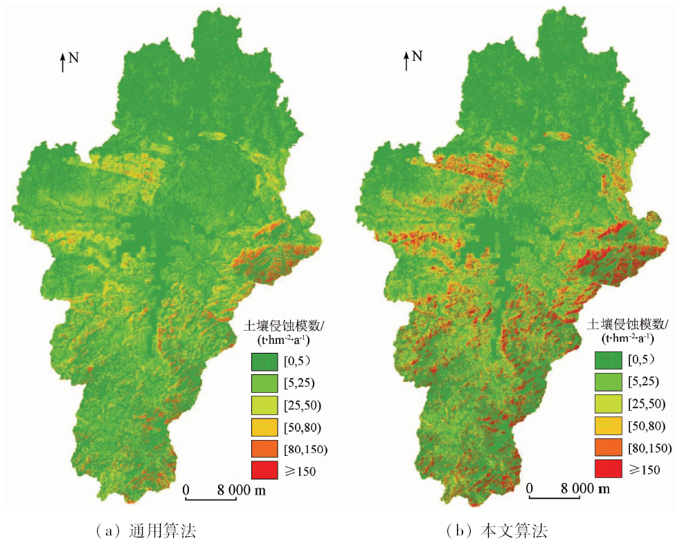
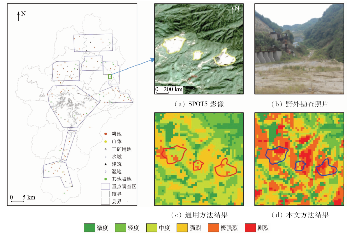
提出考虑地表土地利用/植被对汇流影响的基于多流向上坡汇流累积的地形因子提取算法,改进了修正通用土壤流失方程(revised university soil loss equation,RUSLE)中地形因子算法,提高了土壤侵蚀提取的精度。利用地理信息系统和遥感技术研究了淮河流域商城县的土壤侵蚀强度空间分布及其与环境因素的关系。结果表明: 研究区年平均土壤侵蚀模数为28.16 t·hm -2·a -1,属于中度侵蚀; 总侵蚀面积达905.95 km 2; 随着坡度的升高,土壤侵蚀强度和侵蚀模数也显著升高。研究为RUSLE模型应用在生态功能区进行土壤侵蚀评估提供了技术范例,为该区域治理水土流失和环境可持续发展提供了依据。
In this paper, a topographic factor extraction algorithm based on the accumulation of the multiple flow direction up-slope considering the effect of land use/vegetation on the confluence is proposed, which improves the topographic factor extraction algorithm in revised university soil loss equation (RUSLE) and improves the accuracy of soil erosion extraction. The spatial distribution of soil erosion intensity and its relationship with environmental factors in Shangcheng County of Huaihe River basin were studied by using geographic information system (GIS) and remote sensing (RS) techniques. The results show that the average annual soil erosion modulus is 28.16 t·hm -2·a -1, suggesting moderate erosion. The total erosion area reaches 905.95 km 2, soil erosion intensity and erosion modulus also increase significantly with the increase of slope. The study provides a technical example for the application of the RUSLE model to soil erosion assessment in the ecological functional region and provides an effective basis for soil erosion control and environmental sustainable development in this region.
李亚平, 卢小平, 张航, 路泽忠, 王舜瑶. 基于GIS和RUSLE的淮河流域土壤侵蚀研究——以信阳市商城县为例[J]. 国土资源遥感, 2019, 31(4): 243-249.
Yaping LI, Xiaoping LU, Hang ZHANG, Zezhong LU, Shunyao WANG. Soil erosion in Huaihe River Basin based on GIS and RUSLE:Exemplified by Shangcheng County, Xinyang City. Remote Sensing for Land & Resources, 2019, 31(4): 243-249.
Chen S F . Relationship between land use and soil erosion in the subtropical mountain areas of north Guangdong Province[J].Journal of Arid Land Resources and Environment,2015(2):80-85.
[2]
Qin W, Guo Q, Cao W , et al. A new RUSLE slope length factor and its application to soil erosion assessment in a Loess Plateau watershed[J]. Soil and Tillage Research, 2018,182:10-24.
[3]
Djoukbala O, Mazour M, Hasbaia M , et al. Estimating of water erosion in semiarid regions using RUSLE equation under GIS environment[J]. Environmental Earth Sciences, 2018,77(9):345.
Zhang H M, Yang Q K, Li R , et al. Estimation methods of slope gradient and slope length in watershed based on GIS and multiple flow direction algorithm[J].Transactions of the Chinese Society of Agricultural Engineering,2012(10):159-164.
Zhang H M, Yang Q K, Li R , et al. Research on the estimation of slope length in distributed watershed erosion[J].Journal of Hydraulic Engineering,2012(4):437-444.
Hu G, Song H, Shi X J . Evaluation of topography factors based on the unit contributing catchment area[J]. Scientia Geographica Sinica, 2016,36(4):621-627.
[7]
Mahala A . Soil erosion estimation using RUSLE and GIS techniques:A study of a plateau fringe region of tropical environment[J]. Arabian Journal of Geosciences, 2018,11(13).
[8]
Li Y, Bai X, Zhou Y , et al. Spatial-temporal evolution of soil erosion in a typical mountainous Karst basin in SW China,based on GIS and RUSLE[J]. Arabian Journal for Science and Engineering, 2016,41(1):209-221.
Hu L J, Wang L, Tao K W . Comparison of topographic factors based on single flow direction arithmetic and multiple flow direction arithmetic[J].Science of Surveying and Mapping,2014(6):35-39.
[10]
Desmet P J J, Govers G . A GIS procedure for automatically calculating the USLE LS factor on topographically complex landscape units[J]. Journal of Soil and Water Conservation, 1996,51(5):427.
Yong B, Zhang W C, Chen Y H . A new algorithm of the topographic index 1n( α/tanβ) in TOPMODEL and its resultant analysis[J].Geographical Research, 2007(1):37-45.
Qin W, Cao W H, Zuo C Q , et al. Erosion and sediment yield model of big and middle scale watershed in Loess Plateau considering differentiation between upper and lower of the shoulder line of valleys[J].Journal of Basic Science and Engineering,2015(1):12-29.
Qin W, Zhu Q K, Zhang Y . Soil erosion assessment of small watershed in Loess Plateau based on GIS and RUSLE[J].Transactions of the CSAE,2009(8):157-163.
Liu L F, Bi H X . Research on comparing the topographic index based on the single flow direction arithmetic and multiple flow direction arithmetic——treating Caijiachuan small watershed in Ji County of Shanxi Province as sample[J].Research of Soil and Water Conservation,2006(6):309-310.
Zhang D G, Wang K L, Chen H S , et al. Method and application for extracting topographic index based on DEM[J].Resources and Environment in the Yangtze Basin,2005(6):43-47.
Fang T, Sun Q Y, Liu J , et al. Rainfall-runoff Characteristics of typical area in north shore region of Huaihe middle reach[J].Water Resources and Power,2015(9):12-16.
Du C Z, Sun X H, Meng F Z . Sensitivity evaluation of soil erosion in Dabie mountain area of Huaihe river basin[J].Jiangsu Agricultural Sciences,2009(4):323-325.
Hu W M, Zhou W J, Yu Y H , et al. Estimation of soil erosion in red earth hilly area based on RS and USLE[J].Remote Sensing for Land and Resources,2013(3):171-177.
Ji C C, Li X S, Zeng Y , et al. The ration spatial distribution of soil loss based on remote sensing and GIS in Xuanhua County[J].Remote Sensing for Land and Resources,2010(2):107-112.
Fang G L, Xiang B, Zhao W , et al. Study on soil erosion in LaSa river basin based on GIS and RUSLE[J].Journal of Soil and Water Conservation,2015(3):6-12.
Huang J L, Hong H S, Zhang L P , et al. Study on predicting soil Erosion in Jiulong river watershed based on GIS and USLE[J].Journal of Soil and Water Conservation,2004(5):75-79.
Lian G X . Benefit Analysis of Pilot Project of Comprehensive Control of Soil and Water Loss on Slope Land in Xinyang City —— The Pilot Project of Comprehensive Control of Slope Land in Shangcheng County has achieved remarkable results:Symposium on Comprehensive Control of Soil and Water Loss on Slope Land[Z]. Xiamen: 2011.
Wang X, Li Z B, Li P , et al. Landform distribution features of soil erosion in Ningqiang County[J].Transactions of the Chinese Society of Agricultural Engineering,2012(11):132-137.
 2019, Vol. 31
  ), 张航, 路泽忠, 王舜瑶