Research on urban development and security in border areas of China based on deep learning
MA Xiaoyu1(), ZHANG Xin2,3, LIU Jilei4(), ZHOU Nan2,3, LIU Kejian3, WEI Chunshan5, YANG Peng5
1. School of Earth Sciences and Engineering, Hebei University of Engineering, Handan 056000, China 2. State Key Laboratory of Remote Sensing Science, Institute of Aerospace Information Innovation, Chinese Academy of Sciences, Beijing 100101, China 3. University of Chinese Academy of Sciences, Beijing 100101, China 4. Public Security Remote Sensing Application Engineering Technology Research Center, People’s Public Security University of China, Beijing 100101, China 5. Suzhou Zhexin Information Technology Limited Company, Suzhou 215000, China
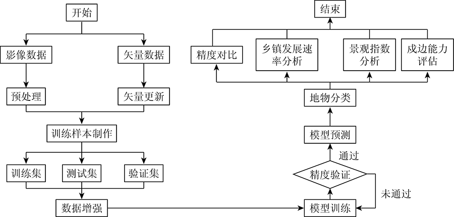
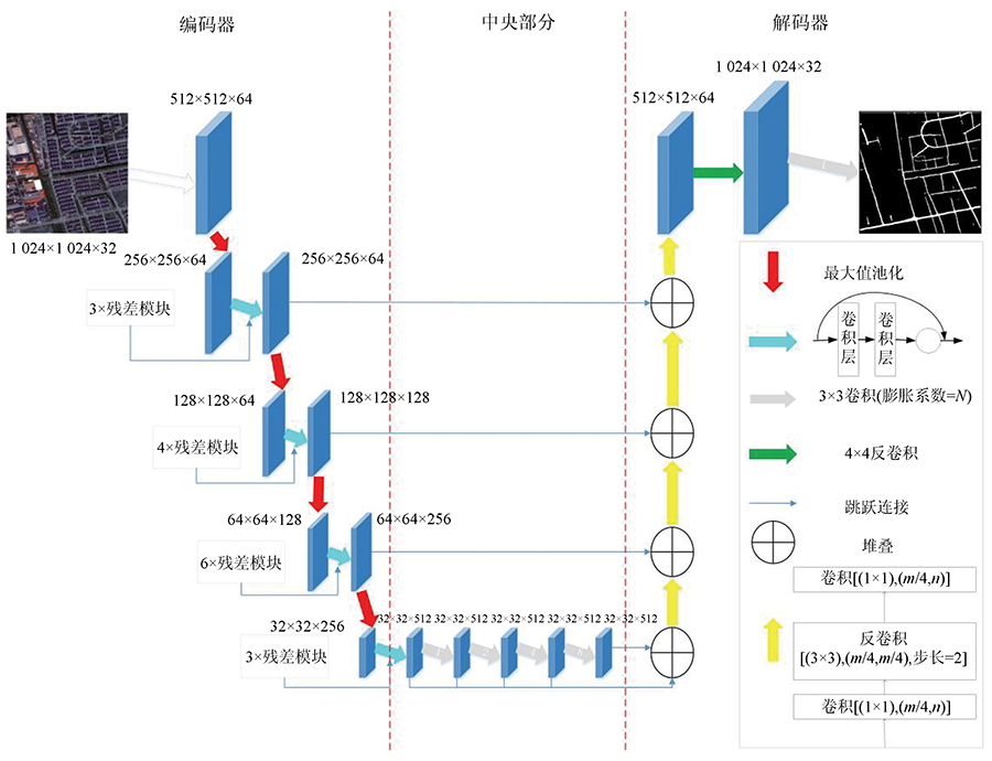
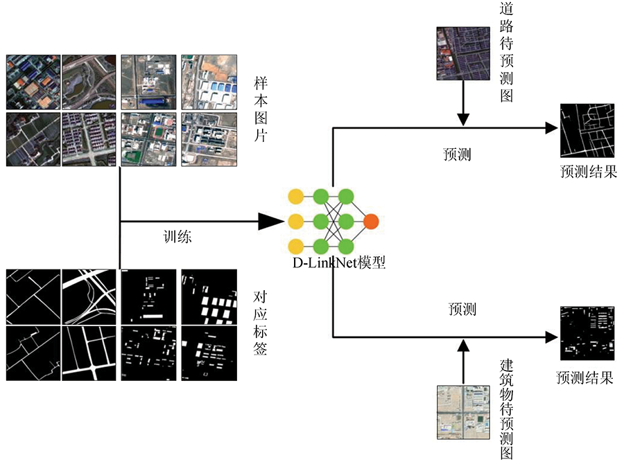
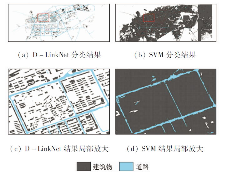
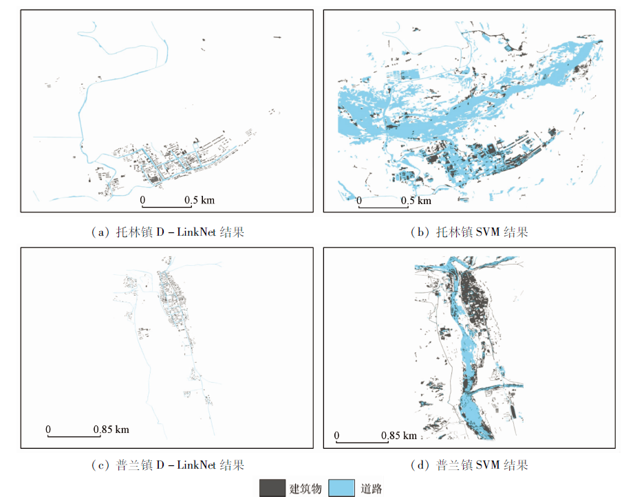
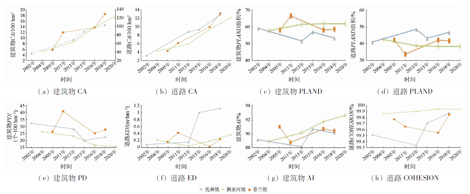
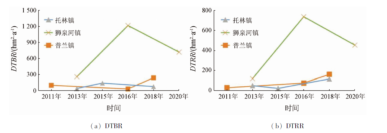
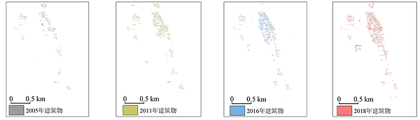
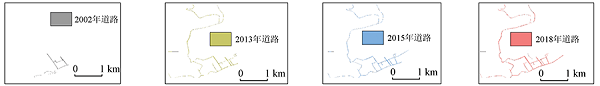
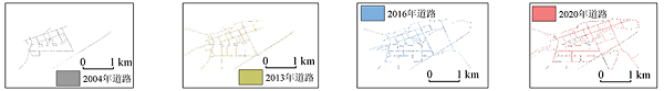
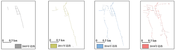
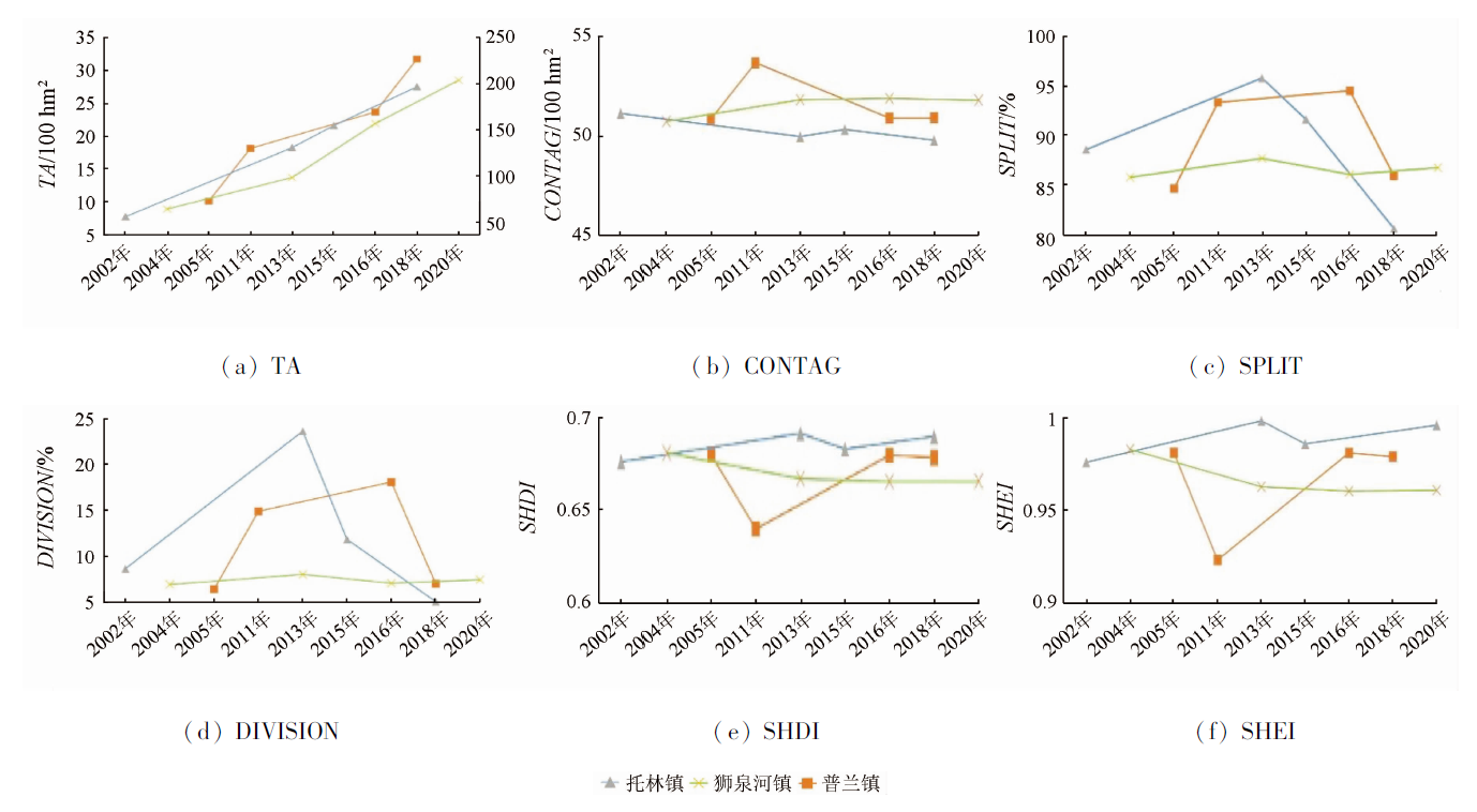
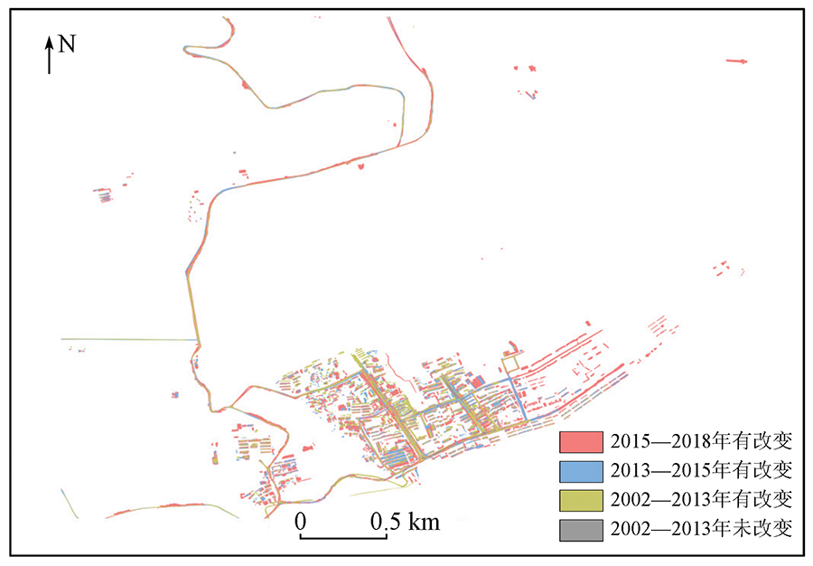
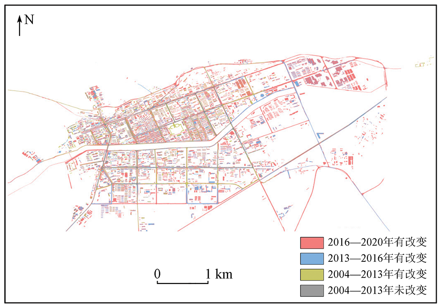
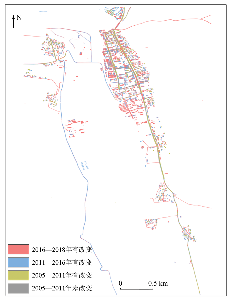
In order to explore the development trend of border cities in China and assess the city’s border defense capability, the D-LinkNet34 deep learning algorithm is used to automate the extraction of buildings and roads in Tuolin, Shiquanhe and Pulan towns in Tibet Autonomous Region, and to analyze the development trend and border defense capability of border towns based on landscape index and population size. Analysis results show that: ① The extraction method based on D-LinkNet deep learning network can effectively further classify urban construction land, with average total progress of more than 80% and IOU above 70%.② The distribution of plaques in the towns of Pulan and Shiquanhe shows a trend of aggregation, and the trend of urban expansion weakened. The distribution of plaques in Tuolin Town shows a scattered trend, and the trend of urban expansion is obvious. ③ The building area is linearly related to the resident population, and the building area of Tuolin Town increased by about 68.75%from 2002 to 2018, and the resident population increased by about 39.00%. The building area of Shiquanhe Town increased by about 70.75% from 2004 to 2020, while the resident population increased by about 68.44%. The building area of Pulan Town increased by about 68.36% from 2005 to 2018, while the resident population increased by about 25.04%. This study provides a new method for quantitative evaluation of the expansion characteristics and border defense capability of border cities, as well as a reference for building China’s border defense capability.
马晓宇, 张新, 刘吉磊, 周楠, 刘克俭, 魏春山, 杨鹏. 基于深度学习的中国边境地区城市发展与安防研究[J]. 自然资源遥感, 2022, 34(2): 231-241.
MA Xiaoyu, ZHANG Xin, LIU Jilei, ZHOU Nan, LIU Kejian, WEI Chunshan, YANG Peng. Research on urban development and security in border areas of China based on deep learning. Remote Sensing for Natural Resources, 2022, 34(2): 231-241.
Dou H T, Qi Y N, Jia R X. Thoughts and countermeasures to accelerate the development of border areas[J]. China Development Observation, 2020, 249(21):39-43.
Shi S Y, Ni J Y. The value implication and formation of the party strategy of governing Tibet in the new era from the perspective of system theory[J]. Journal of Xizang Minzu University(Philosophy and Social Sciences Edition), 2021, 42(1):8-14,153.
Yang M H, Wang Z B. Types,causes and governance of “hollowing” in China’s land border areas[J]. Journal of Sichuan Normal University (Social Sciences Edition), 2020, 47(6):13-24.
Fang S J, Zhao R Z. The border-town’s garrison role and development fromthe perspective of national security[J]. Journal of Harbin Institute of Technology (Social Science Edition), 2020, 22(5):1-8.
Chen B X, Sun X T, Song H L. The characteristics and mechanism of spatial expansion in Jinan City center[J/OL]. Journal of Geomatics, 2020:1-5[2021-05-18].
Chen M F, Liu F, Zhao Y L, et al. The expansion and gradient evolution of impervious surface within the Guangdong - HongKong - Macao Greater Bay Area from 1987 to 2017[J]. Geo-Information Science, 2021, 23(3):443-455.
Zhang Q Y, Gao Y B, Zhang Y, et al. Spatial process,motivation and model of the expansion of built-up areas of island city:A case study of Xiamen Island (2002—2018)[J]. Journal of Fujian Normal University(Natural Science Edition), 2021, 37(1):98-106.
Chen F E, Yang W N. Evolution of urban development pattern in Zhengzhou metropolitan area:Based on DMSP/OLS night light data[J]. Journal of China West Normal University(Natural Science), 2021, 42(2):167-173.
Song Y H, Jiao L M, Liu J F, et al. Analysis of the factors affecting the degree of urban expansion:Taking Wuhan City as an example[J]. Geomatics and Information Science of Wuhan University, 2021, 46(3):417-426.
Zhou R F, Zhou L. Analysis of spatial expansion characteristics of typical Chinese border cities[J]. Science of Surveying and Mapping, 2019, 44(9):54-60.
[11]
Vani M, Prasad P R C. Assessment of spatio-temporal changes in land use and land cover,urban sprawl,and land surface temperature in and around Vijayawada City,India[J]. Environment,Development and Sustainability, 2020, 22(4):3079-3095.
doi: 10.1007/s10668-019-00335-2
[12]
Robert S, Fox D, Boulay G, et al. A framework to analyse urban sprawl in the French Mediterranean coastal zone[J]. Regional Environmental Change, 2019, 19(2):559-572.
doi: 10.1007/s10113-018-1425-4
[13]
Kovacs Z, Farkas Z J, Egedy T, et al. Urban sprawl and land conversion in post-socialist cities:The case of metropolitan Budapest[J]. Cities, 2019, 92(SEPa):71-81.
[14]
Canedoli C, Crocco F, Comolli R, et al. Landscape fragmentation and urban sprawl in the urban region of Milan[J]. Landscape Research, 2018, 43(5):632-651.
doi: 10.1080/01426397.2017.1336206
 2022, Vol. 34
  ), 张新2,3, 刘吉磊4(