Suitability regionalization of Myrica rubra planting in Zhejiang Province
ZHONG Le1(), ZENG Yan2,3(), QIU Xinfa1, SHI Guoping4
1. School of Applied Meteorology, Nanjing University of Information Science & Technology, Nanjing 210044, China 2. Key Laboratory of Transportation Meteorology, China Meteorological Administration, Nanjing 210008, China 3. Nanjing Joint Institute for Atmospheric Sciences, Nanjing 210008, China 4. School of Geography, Nanjing University of Information Science & Technology, Nanjing 210044, China
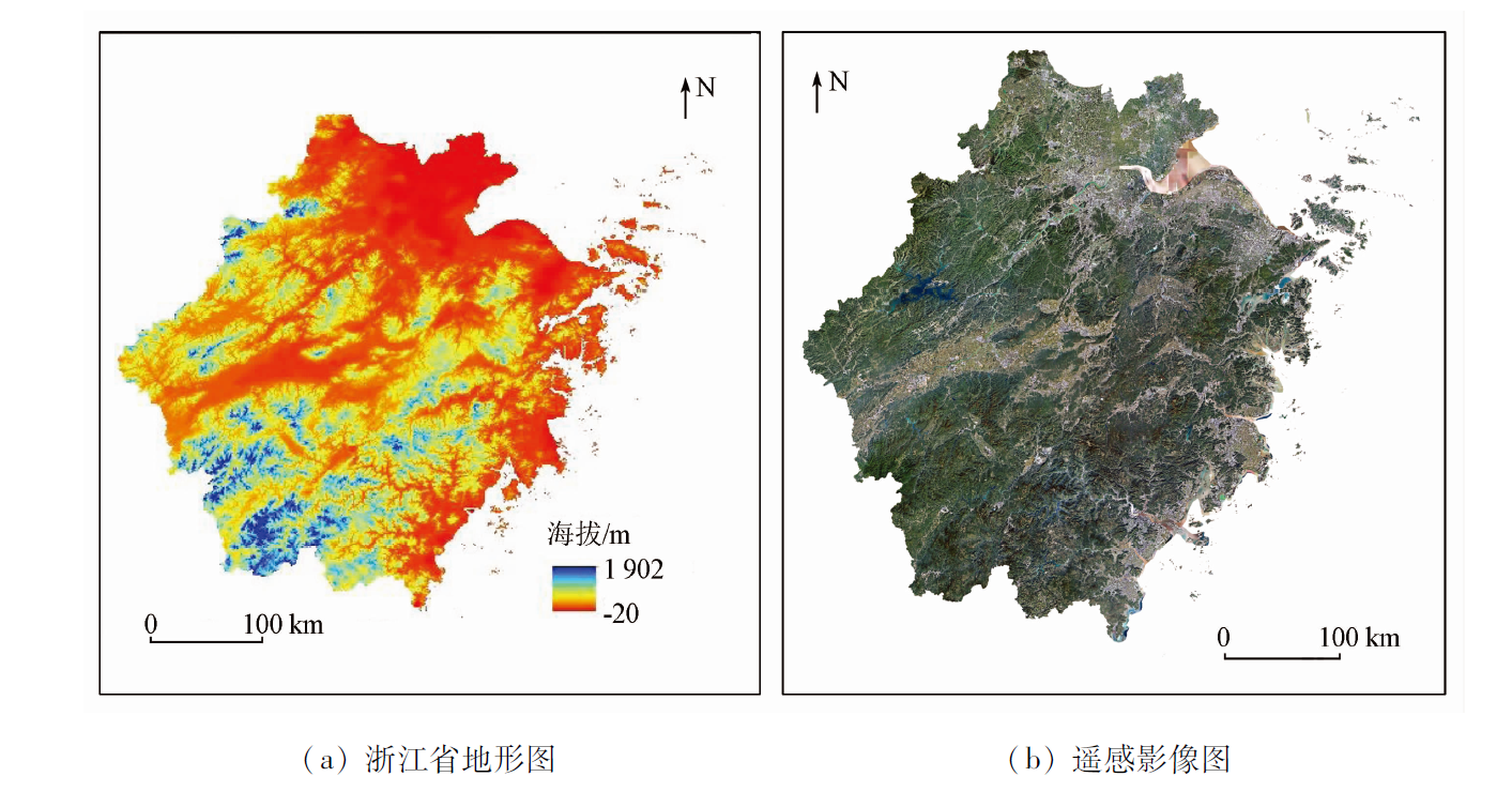
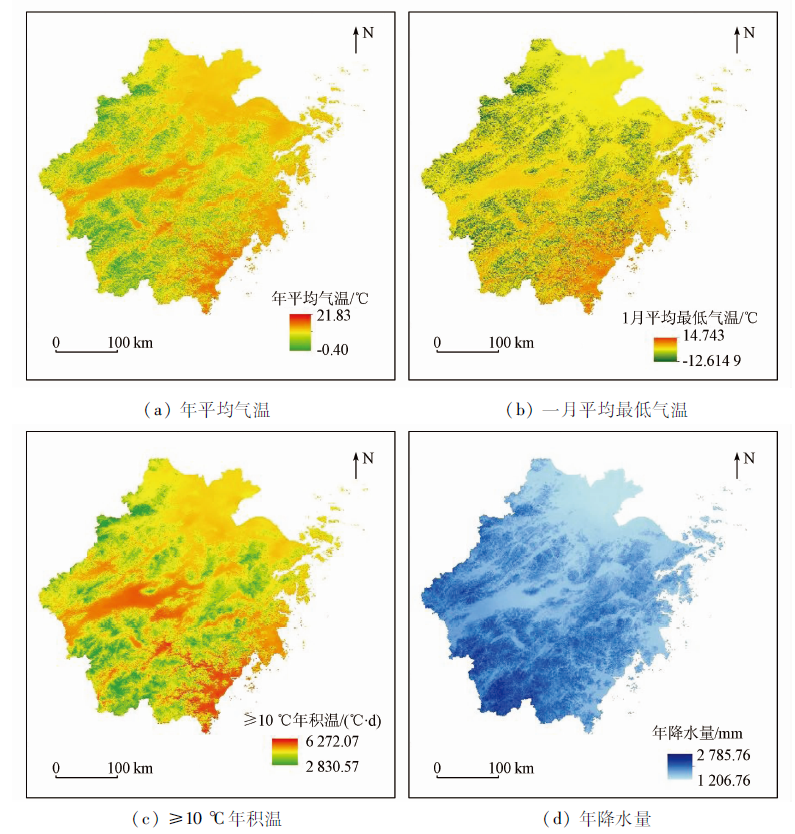
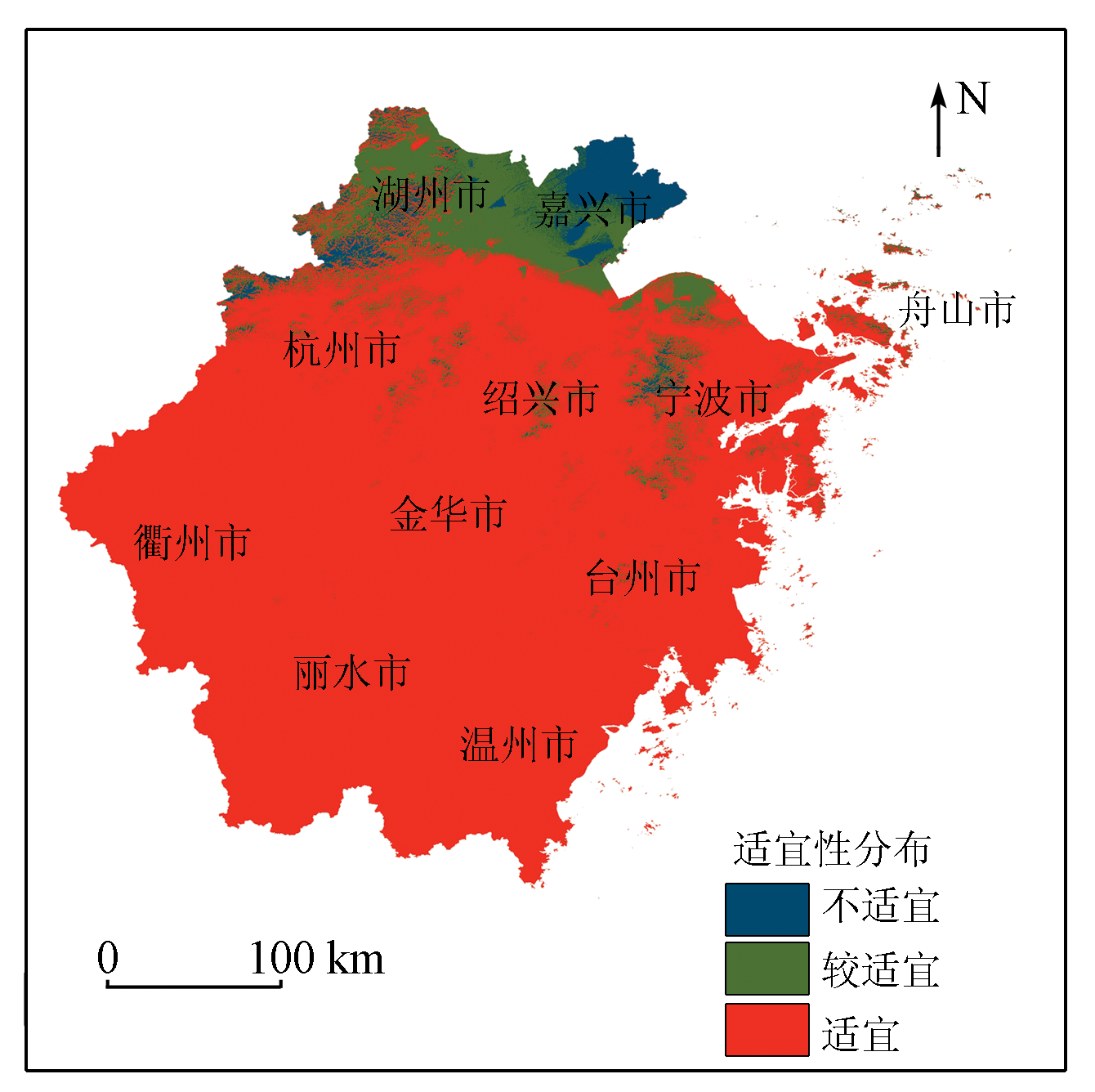
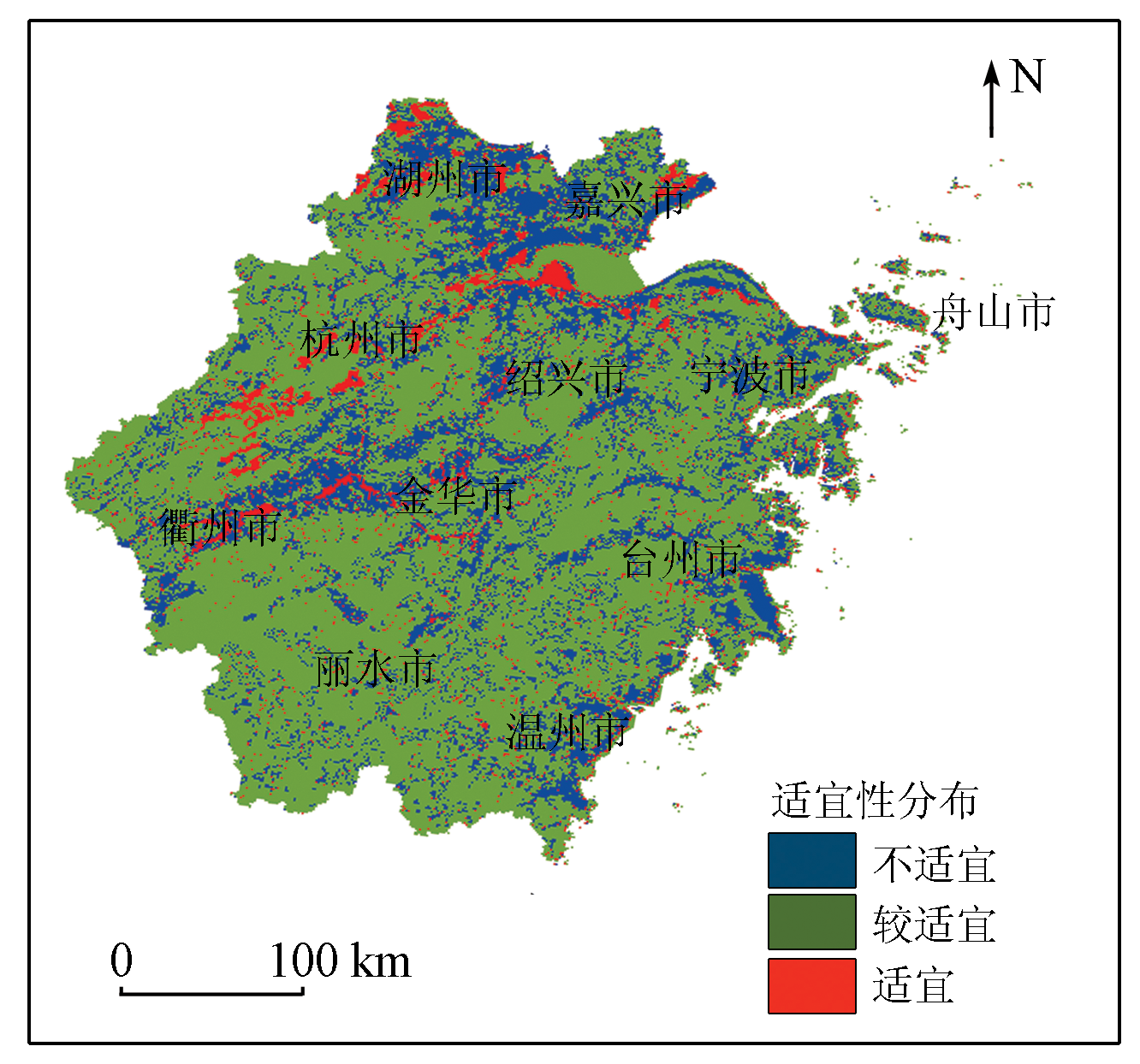
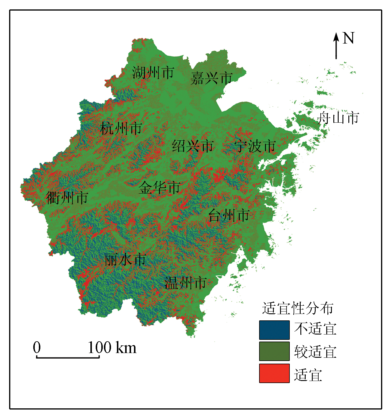
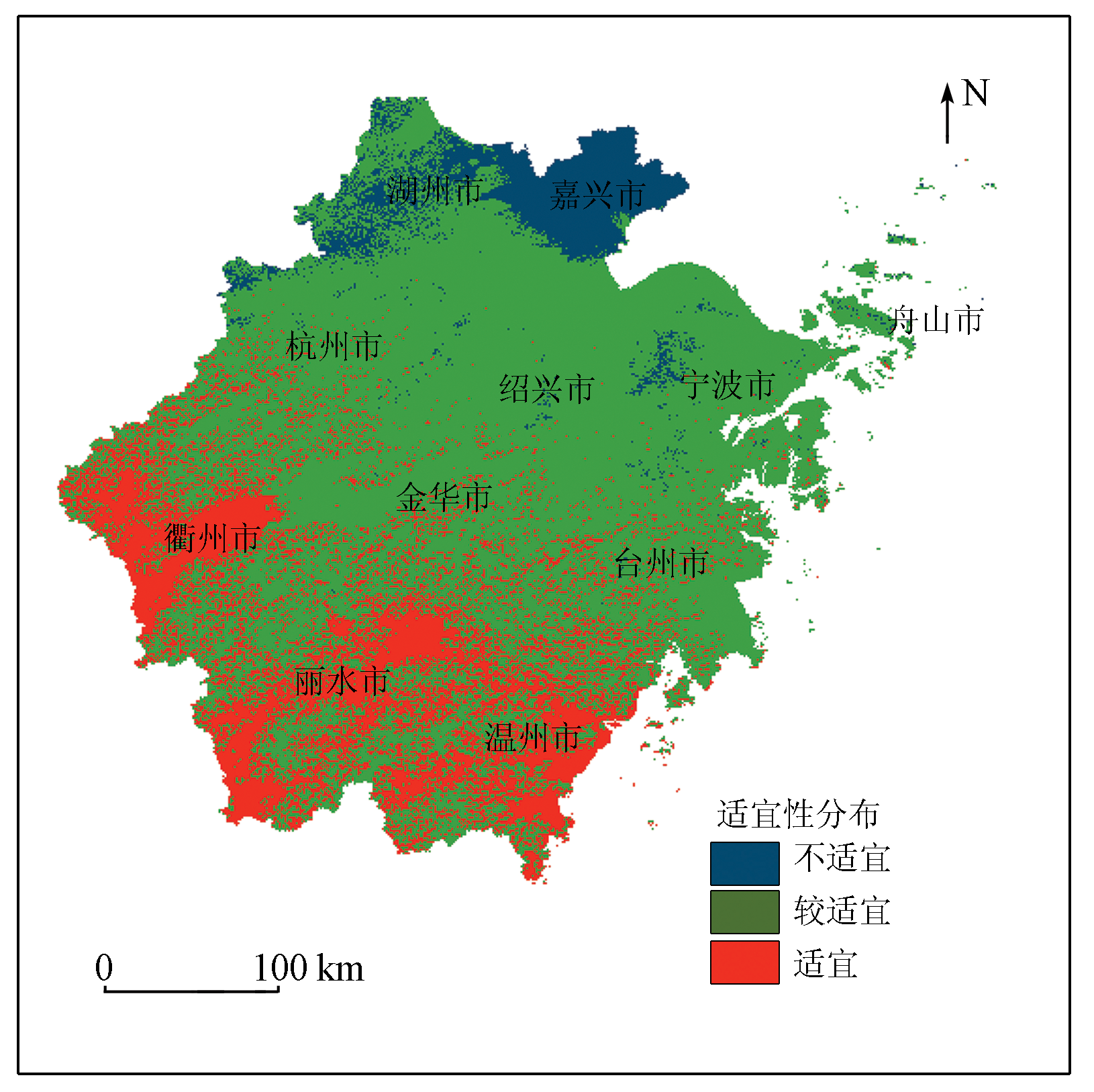
Myrica rubra is a specialty crop in Zhejiang Province. Its cultivation area in Zhejiang ranks first in China. This study aims to comprehensively investigate and analyze the suitability of Myrica rubra planting in Zhejiang and better serve the Myrica rubra planting by scientifically using modern meteorological observation data. Based on the distributed simulation of climate factors, this study introduced the influencing factors related to soil and terrain and determined the weights of these factors through the analytic hierarchy process (AHP). Then, in combination with the suitability grade indices of various influencing factors, this study divided Zhejiang into regions suitable, fairly suitable, and unsuitable for Myrica rubra planting. The results are as follows: Regions with a suitable climate occupy most of Zhejiang, indicating superior climate resources; Zhejiang Province enjoys excellent soil conditions and roughly varies between regions fairly suitable and suitable for Myrica rubra planting regarding soil conditions; The terrain varies greatly and is a key factor in the suitability of precise Myrica rubra planting. The regions with suitable terrains have altitudes of 250~450 m and slopes of 5°~25°; Except for northern Zhejiang and the boundary between Shaoxing and Ningbo cities, Zhejiang is suitable or fairly suitable for Myrica rubra planting. This study achieved the spatial simulation of meteorological factors, thus providing data support for the development and improvement of the Myrica rubra planting layout in Zhejiang and being of great practical significance for improving the yield and quality of Myrica rubra.
Jin Z F, Wang L H, Feng T, et al. Major agricultural meteorological disasters and prevention of Myrica rubra in Zhejiang[J]. Chinese Agricultural Science Bulletin, 2007, 23(6):638-641.
doi: 10.11924/j.issn.1000-6850.0706638
Li S P, Jin Z F, Feng T. Characteristics of climatic resources and climatic change about main product districts of Myrica rubra in Zhejiang Province[J]. Acta Agriculturae Zhejiangensis, 2008(3):199-202.
[3]
杨照渠. 浙江省杨梅生产现状与发展对策[J]. 中国果业信息, 2003, 19(4):5-6.
Yang Z Q. Production status and development countermeasures of Myrica rubra in Zhejiang[J]. China Fruit News, 2003, 19(4):5-6.
Liang S M, Zhu T T, Zhang S W, et al. Effects on the growth of Myrica rubra and preventive measures from major agrometeorological disasters[J]. Modern Horticulture, 2021, 44(3):122-124.
He X H, Chen L G, Chen Y, et al. Review on germplasm resources of Myrica and their exploitation in China[J]. Journal of Fruit Science, 2004, 21(5):467-471.
Jin Z F, Feng X Y, Chen S P. Change characteristics of indoor temperature and its effects on growing period of Chinese bayberry (Myrica rubra) in plastic-house[J]. Acta Agriculturae Zhejiangensis, 2004(2):7-9.
Chen S Z, Li Z L, Xu L M, et al. The climatic ecological regionalization of Myrica rubra in Yunnan Province[J]. Journal of Yunnan Agricultural University(Natural Science), 2004, 19(3):307-310.
Jin Z F, Yang Z E, Zhao H B, et al. Comprehensive regionalization of Torreya grandis Merrillii cultivation based on climate,terrain and soil factors by GIS technology in Zhejiang Province[J]. Scientia Silvae Sinicae, 2012, 48(1):42-47.
Li L C, Chen F Z, Wang J Y, et al. Climate suitability regionalization for Taiwan green jujube introduction and expansion in Fujian Province using GIS[J]. Chinese Journal of Eco-Agriculture, 2017, 25(1):47-54.
[13]
Zhang S, Liu X, Wang X, et al. Evaluation of coffee ecological adaptability using fuzzy,AHP,and GIS in Yunnan Province,China[J]. Arabian Journal of Geosciences, 2021, 14(14):1366.
doi: 10.1007/s12517-021-07795-9
Jin Z F, Deng R, Huang J F. Regional planning for planting Myrica rubra based on GIS in Zhejiang Province[J]. Transactions of the Chinese Society of Agricultural Engineering, 2008(8):214-218.
[15]
陈志银, 叶明儿. 杨梅生长的气候条件初探[J]. 浙江气象, 1989(3):37-39.
Chen Z Y, Ye M E. Preliminary study on the climatic conditions of Myrica rubra[J]. Journal of Zhejiang Meteorology, 1989(3):37-39.
Chen Z Y. A Preliminary study on the influence of altitude on the flowering period and quality of Myrica rubra[J]. Journal of Zhejiang University(Agriculture and Life Sciences), 1989(3):82-84.
[18]
缪松林. 不同土壤质地对杨梅生长和结果的影响[J]. 中国果树, 1987(4):7-10.
Miao S L. Effects of different soil textures on the growth and fruiting of Myrica Rubra[J]. China Fruits, 1987(4):7-10.
Cui H, Gao X, Wei D F. Analysis about the climate condition and planting zones of Chinese Waxmyrtle at Nan’an Municiple[J]. Fujian Science & Technology of Tropical Crops, 2019, 44(4):54-56.
[21]
缪松林. 中国杨梅生态区划研究[J]. 浙江农业大学学报, 1995(4):366-372.
Miao S L. Study on ecological regionalization of Myrica rubra in China[J]. Journal of Zhejiang Agricultural University, 1995(4):366-372.
Ruan Z W, Wu C Y, Huang J Y, et al. Analysis of climatic conditions for introducing Bayberry in Fenyi County of Jiangxi Province[J]. Horticulture & Seed, 2012(6):58-61.
Liu Y, Mao Y H, Wei Y. The influence of meteorological factors on Bayberry and garden selection techniques[J]. Agricultural Technology Service, 2009, 26(12):111-112,145.
Lin H M, Zhang W L. Differences and similarites between principal component analysis and factor analysis and SPSS software[J]. Statistical Research, 2005(3):65-69.
Han X H, Zhang Y H, Sun F J, et al. A method for determining index weights based on principal component analysis[J]. Journal of Sichuan Ordance Zngineerirg, 2012, 33(10):124-126.
Zhao Y L. Study and application of analytic hierarchy process of mine geological environment:A case study in Hainan Island[J]. Remote Sensing for Land and Resources, 2020, 32(1):148-153.doi:10.6046/gtzyyg.2020.01.20.
doi: 10.6046/gtzyyg.2020.01.20
Zhang X D, Liu X N, Zhao Z P, et al. Geological disaster hazard assessment in Yanchi County based on AHP[J]. Remote Sensing for Land and Resources, 2019, 31(3):183-192.doi:10.6046/gtzyyg.2019.03.23.
doi: 10.6046/gtzyyg.2019.03.23
Wang D D, Qiu X F, Zeng Y, et al. Suitability regionalization of tea trees cultivation based on distributed model simulation[J]. Scientia Meteorologica Sinica, 2018, 38(1):121-129.
Qiu X F, Qiu Y P, Zeng Y. Distributed modeling of monthly mean air temperature of rugged terrain of Chongqing[J]. Advances in Earth Sciences, 2009, 24(6):621-628.
[30]
李梦洁. 浙江省山地热量资源分布式模拟[D]. 南京: 南京信息工程大学, 2008.
Li M J. The simulation of terrain heat resources in Zhejiang Province[D]. Nanjing: Nanjing University of Information Science & Technology, 2008.
Pan H, Qiu X F, Gao T, et al. Study on the estimation of precipitation with the data of TRMM and NCEP-FNL[J]. Research of Soil and Water Conservation, 2014, 21(2):116-122.
Qin W, Huang Q Y, Qin Z H, et al. Spatiotemporal analysis of drought in sugarcane planting areas of Guangxi by remote sensing[J]. Remote Sensing for Natural Resources, 2022, 34(2):261-270.doi:10.6046/zrzyyg.2021191.
doi: 10.6046/zrzyyg.2021191
Wang Y R, Han P P, Guan S J, et al. Information extraction of Dracaena sanderiana planting area based on Landsat8 OLI data[J]. Remote Sensing for Land and Resources, 2019, 31(1):133-140.doi:10.6046/gtzyyg.2019.01.18.
doi: 10.6046/gtzyyg.2019.01.18
Huang P, Pu J W, Zhao Q Q, et al. Research progress and development trend of remote sensing information extraction methods of vegetation[J]. Remote Sensing for Natural Resources, 2022, 34(2):10-19.doi:10.6046/zrzyyg.2021137.
doi: 10.6046/zrzyyg.2021137
 2023, Vol. 35
  ), 曾燕2,3(