Differences in rocky desertification information extracted from GF-6 and Landsat8 using the pixel unmixing method: A case study of Puding County
ZHANG Shibo1,2(), HU Wenmin2,3,4(), HAN Zhenying1, LI Guo2,3, WANG Zhongcheng1, GAO Zhihai4
1. College of Forestry, Central South University of Forestry and Technology, Changsha 410004, China 2. Engineering Technology Research Center of Big Data for Landscape Resources in Natural Protected Areas of Hunan Province, Changsha 410004, China 3. Department of Landscape Architecture, Central South University of Forestry and Technology, Changsha 410004, China 4. Institute of Forest Resource Information Techniques, Chinese Academy of Forestry, Beijing 100001, China
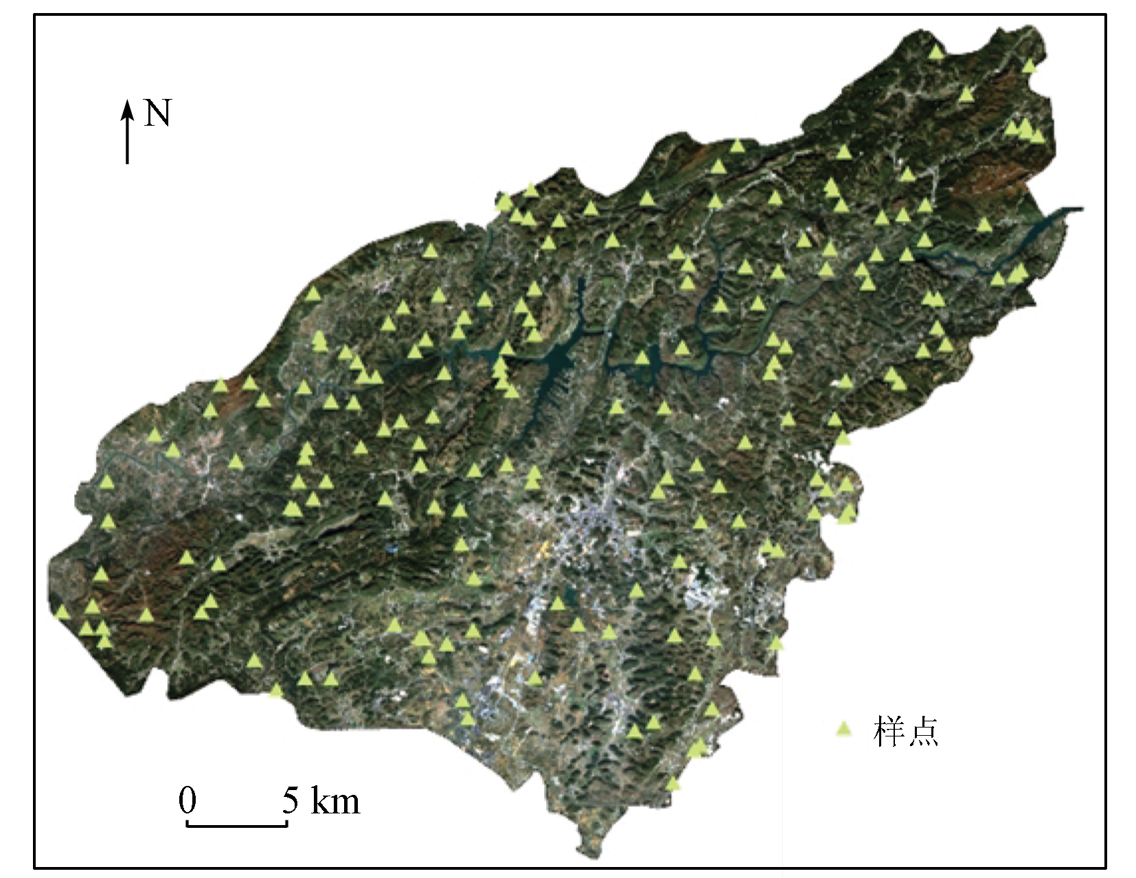
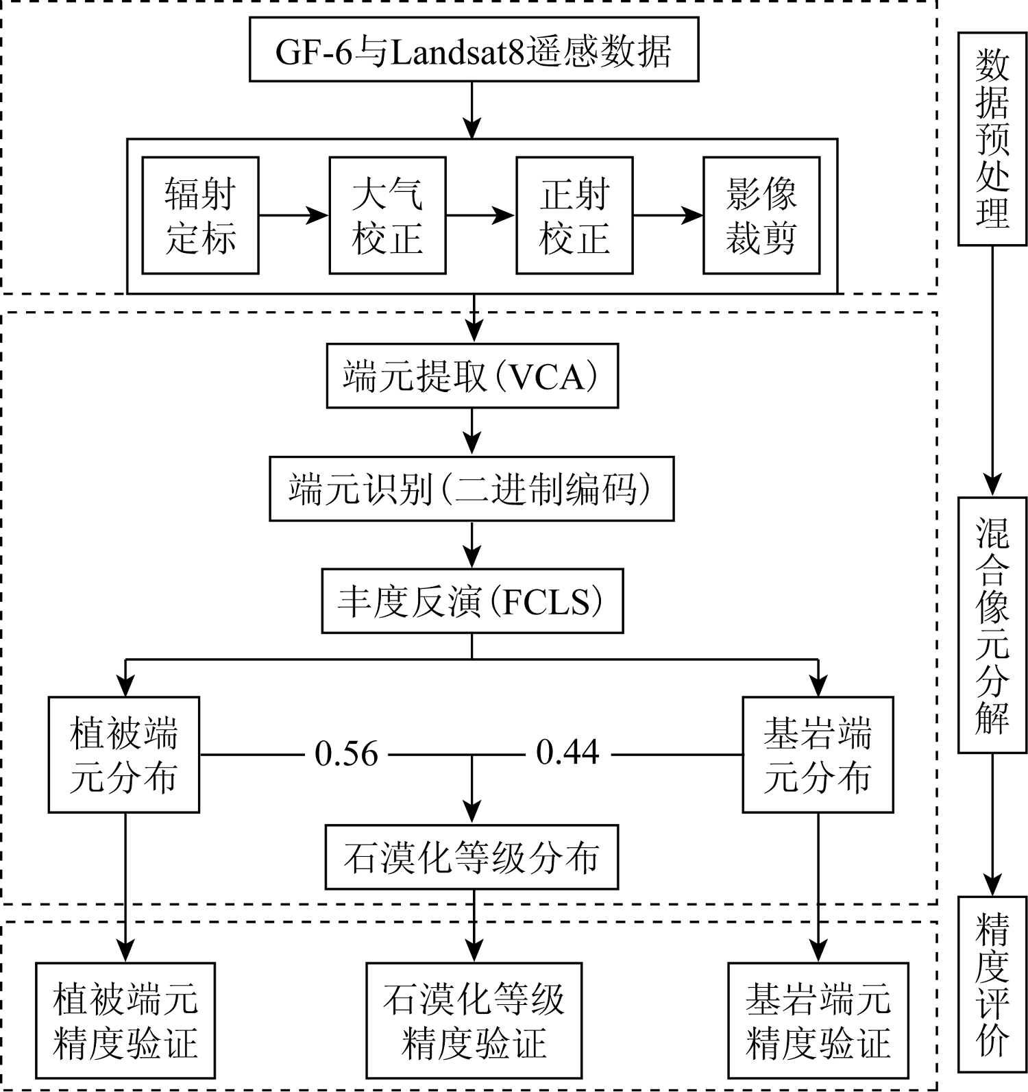
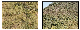
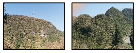
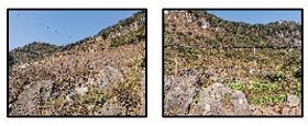
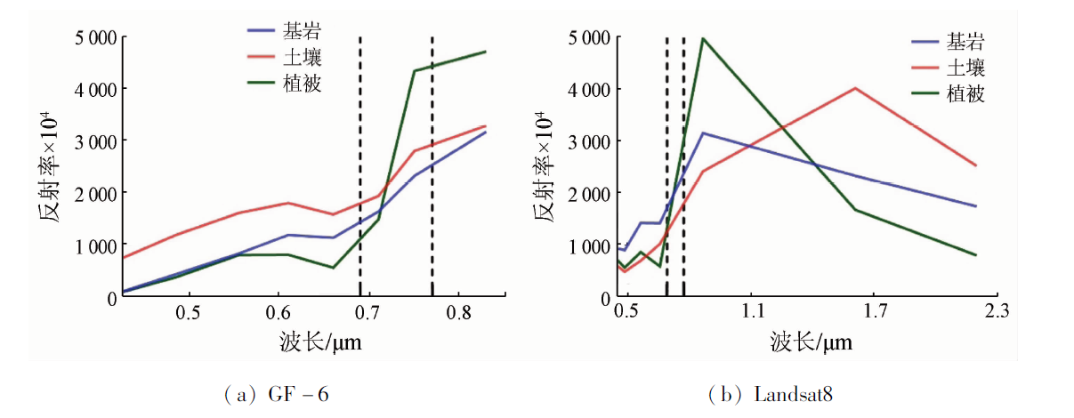
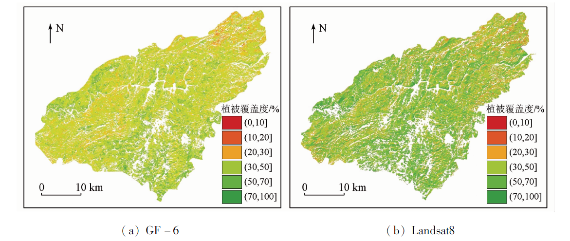
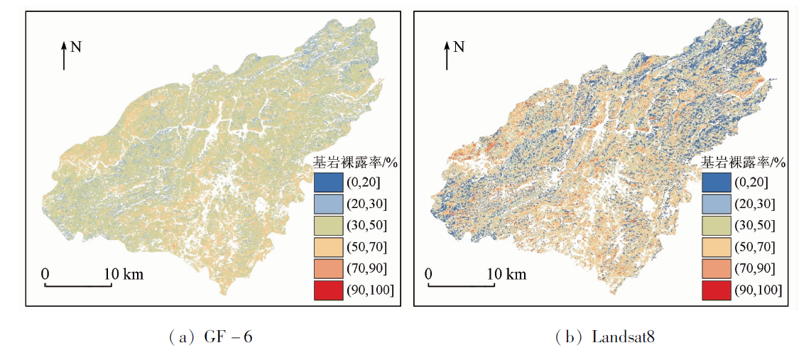
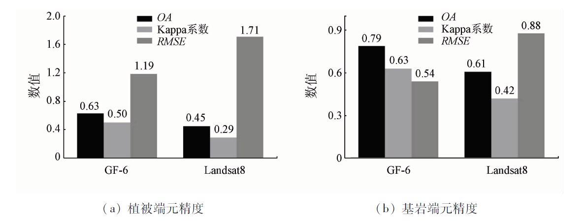
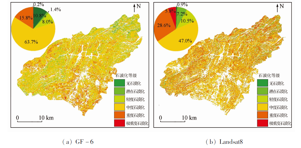
Different moderate-resolution remote sensing satellites exhibit various effects in extracting rocky desertification information using the pixel unmixing method. Comparing these various effects can help further improve the extraction accuracy of rocky desertification information. By extracting information on rocky desertification in Puding County, Guizhou Province from GF-6 and Landsat8 using the pixel unmixing method, this study investigated the end member characteristics and desertification grade differences between GF-6 and Landsat8. Furthermore, this study explored the feasibility and effectiveness of GF-6 in extracting rocky desertification information. The results are as follows: ① Within the red-edge band of GF-6 data, the vegetation end member exhibited significantly different spectrum curves from bedrock and soil end members, making it easier to identify the vegetation end member. ② In terms of end member extraction accuracy of rocky desertification information, GF-6 and Landsat8 yielded overall accuracy (OA) of 0.63 and 0.45 in extracting the vegetation end member, respectively, corresponding to Kappa coefficients of 0.50 and 0.29 and RMSEs of 1.19 and 1.71, respectively. Moreover, GF-6 and Landsat8 yielded OA of 0.79 and 0.61 in extracting the bedrock end member, respectively, corresponding to Kappa coefficients of 0.63 and 0.42 and RMSEs of 0.54 and 0.88, respectively. ③ In the evaluation of rocky desertification grades, GF-6 and Landsat8 yielded OA of 0.76 and 0.59 in extracting rocky desertification grades, respectively, corresponding to Kappa coefficients of 0.56 and 0.38 and RMSEs of 0.64 and 1.27. Therefore, GF-6 outperforms Landsat8 in the accuracy of extracting rocky desertification information using the pixel unmixing method. In addition, the red-edge band of GF-6 data can effectively identify the vegetation information in areas with rocky desertification. In summary, the pixel unmixing method based on GF-6 data can be practically applied to rocky desertification monitoring.
张士博, 胡文敏, 韩祯颖, 李果, 王忠诚, 高志海. GF-6与Landsat8混合像元分解的石漠化信息提取差异研究——以普定县为例[J]. 自然资源遥感, 2023, 35(3): 274-283.
ZHANG Shibo, HU Wenmin, HAN Zhenying, LI Guo, WANG Zhongcheng, GAO Zhihai. Differences in rocky desertification information extracted from GF-6 and Landsat8 using the pixel unmixing method: A case study of Puding County. Remote Sensing for Natural Resources, 2023, 35(3): 274-283.
Yao Y H. Progress and prospect of Karst rocky desertification research in Southwest China[J]. Progress in Geography, 2014, 33(1):76-84.
doi: 10.11820/dlkxjz.2014.01.009
[3]
Qian C, Qiang H, Wang F, et al. Optimization of rocky desertification classification model based on vegetation type and seasonal characteristic[J]. Remote Sensing, 2021, 13(15):2935.
doi: 10.3390/rs13152935
[4]
Zhang J Y, Dai M H, Wang L C, et al. The challenge and future of rocky desertification control in Karst areas in southwest China[J]. Solid Earth, 2016, 7(1):83-91.
doi: 10.5194/se-7-83-2016
[5]
Zhang J, Liu M, Liu X, et al. Spectral analysis of seasonal rock and vegetation changes for detecting Karst rocky desertification in southwest China[J]. International Journal of Applied Earth Observation and Geoinformation, 2021, 100:102337.
doi: 10.1016/j.jag.2021.102337
Zhong G S, Hai Y, Zheng H, et al. Current situation and measures of Karst rocky desertification control in Southwest China[J]. Journal of Yangtze River Scientific Research Institute, 2021, 38(11):38-43.
Du W P, Yan H M, Zhen L, et al. The experience and practice of desertification control in Karst region of southwest China[J]. Acta Ecologica Sinica, 2019, 39(16):5798-5808.
[8]
Li Y, Xie J, Luo G, et al. The evolution of a Karst rocky desertification land ecosystem and its driving forces in the Houzhaihe area,China[J]. Open Journal of Ecology, 2015, 5(10):501-512.
doi: 10.4236/oje.2015.510041
[9]
Tong X, Wang K, Yue Y, et al. Quantifying the effectiveness of ecological restoration projects on long-term vegetation dynamics in the Karst regions of Southwest China[J]. International Journal of Applied Earth Observation and Geoinformation, 2017, 54:105-113.
doi: 10.1016/j.jag.2016.09.013
[10]
Wang H, Li Q, Du X, et al. Quantitative extraction of the bedrock exposure rate based on unmanned aerial vehicle data and Landsat8 OLI image in a Karst environment[J]. Frontiers of Earth Science, 2018, 12(3):481-490.
doi: 10.1007/s11707-017-0681-9
Wang M M, Wang S J, Bai X Y, et al. Evolution characteristics of Karst rocky desertification in typical small watershed and the key characterization factor and driving factor[J]. Acta Ecologica Sinica, 2019, 39(16):6083-6097.
Zheng H R, Luo H X, Xiang H Y, et al. Research on vegetation information extraction and distribution characteristics of rocky desertification area by means of object oriented approach[J]. Resources and Environment in the Yangtze Basin, 2018, 27(3):648-657.
Zhou D, Ni Z Y, Yang Z Y. Object-oriented remote sensing information extraction method for rocky desertification in Karst area: A case study of Dafang County,Guizhou[J]. Journal of Geomechanics, 2018, 24(2):263-273.
Xu H F, Wang Y, Liu Y G, et al. Analysis of the spatial and temporal evolution and driving factors of rocky desertification in typical cluster depression areas in the past 30 years based on Google Earth Engine:Taking Xichou County as an example[J]. Research of Soil and Water Conservation, 2022, 29(4):407-414.
Ye J, Zhang B, Xu J Q, et al. Research on the enhancement of stony desertification information by remote sensing vegetation indexes[J]. Geospatial Information, 2021, 19(9):14-18,157.
[16]
Yang H, Deng F, Fu H C, et al. Estimation of rape-cultivated area based on decision tree and mixed pixel decomposition[J]. Journal of the Indian Society of Remote Sensing, 2021, 49: 1285-1292.
doi: 10.1007/s12524-021-01309-6
Chen J, Huang Y C, Li P F. Impervious surface area classification based on partial unmixing of multi-season mixed pixels[J]. Science of Surveying and Mapping, 2021, 46(4):90-99.
Liu R J, Zhang J L, Chen P G. Spatial distribution changes of the pinus densata forests in Shangrila City based on mixed pixel decomposition[J]. Journal of Northwest Forestry University, 2021, 36(1):9-17.
Yang M X, Zhang J L, Cao Y, et al. Evaluation on spectral endmember of pinus yunnanensis based on Landsat8[J]. Journal of Southwest Forestry University(Natural Sciences), 2017, 37(3):165-169.
Fang L J, Zhan Y J, Lei S T, et al. Endmembers extraction for hyperspectral images based on vertex component analysis[J]. Ship Electronic Engineering, 2014, 34(8):154-157,181.
Wang L, Wang W, Liu B N. Application of vertex component analysis in end member extraction for hyperspectral image[J]. Information Technology, 2022(1):37-43.
[22]
王忠良. 基于线性混合模型的高光谱图像压缩感知研究[D]. 西安: 西北工业大学, 2015.
Wang Z L. Study on compressive sensing of hyperspectral imagery based on linear mixing models[D]. Xi’an: Northwestern Polytechnical University, 2015.
Zhang W Y, Wang B T. Discussion on classification and gradation of Karst rocky desertification in Guizhou Province[J]. Journal of Nanjing Forestry University ( Natural Sciences Edition), 2015, 39(2):148-154.
Hu S G, Zhang Z X, Xia K J. Information extraction of Karst rocky desertification using remote sensing[J]. Journal of Geo-Information Science, 2010, 12(6):870-879.
Wang R Q, Jiang X H, Nie T. Spatiotemporal varitation NDVI and its driving forces in the Pearl River basin based on geodetector[J]. Pearl River, 2022, 43(7):61-73.
Xi H P, Wang S J, Bai X Y, et al. Spatio-temporal characteristics of rocky desertification in typical Karst area of Southwest China:A case study of Puding Country,Guizhou Province[J]. Acta Ecologica Sinica, 2018, 38(24):8919-8933.
He X N, Cao J N, Gao P, et al. An improved algorithm of endmember extraction based on vertex component analysis[J]. Bulletin of Surveying and Mapping, 2013(7):30-34,81.
[28]
Pu J, Zhao X, Dong P, et al. Extracting information on rocky desertification from satellite images:A comparative study[J]. Remote Sensing, 2021, 13(13):2497.
doi: 10.3390/rs13132497
 2023, Vol. 35
  ), 胡文敏2,3,4(