Investigation and applications of rocky desertification based on GF-5 hyperspectral data
LI Na1(), GAN Fuping1(), DONG Xinfeng1, LI Juan2, ZHANG Shifan3, LI Tongtong3
1. China Aero Geophysical Survey and Remote Sensing Center for Natural Resource, Beijing 100083, China 2. Aerospace Information Research Institute, Chinese Academy of Sciences, Beijing 100101, China 3. School of Earth Sciences and Resource, China University of Geosciences (Beijing), Beijing 100083, China
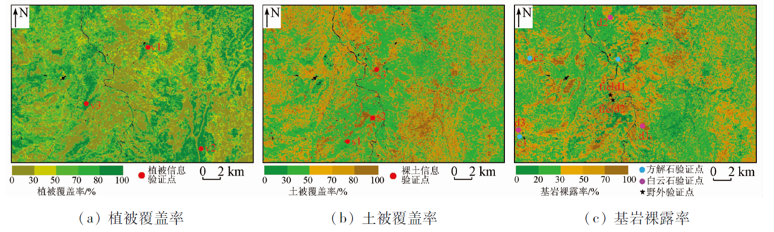
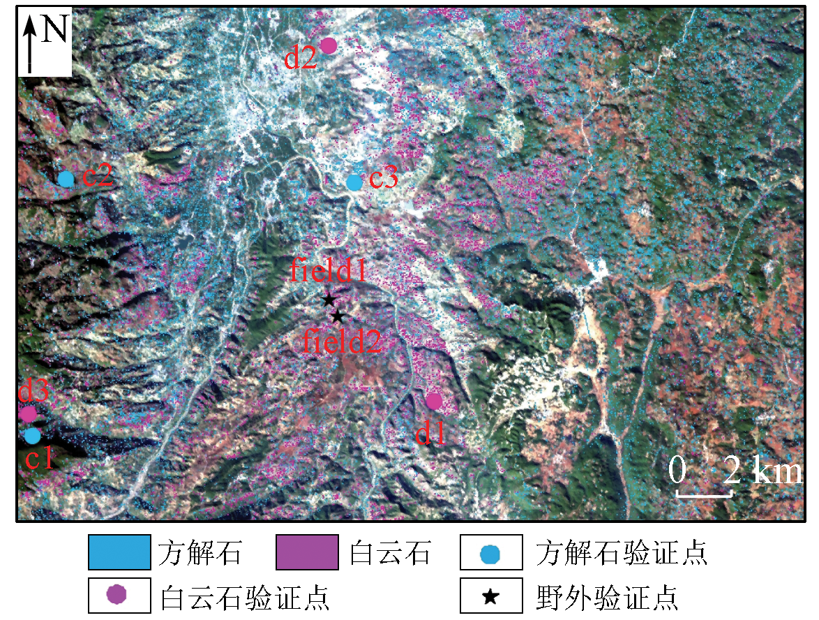
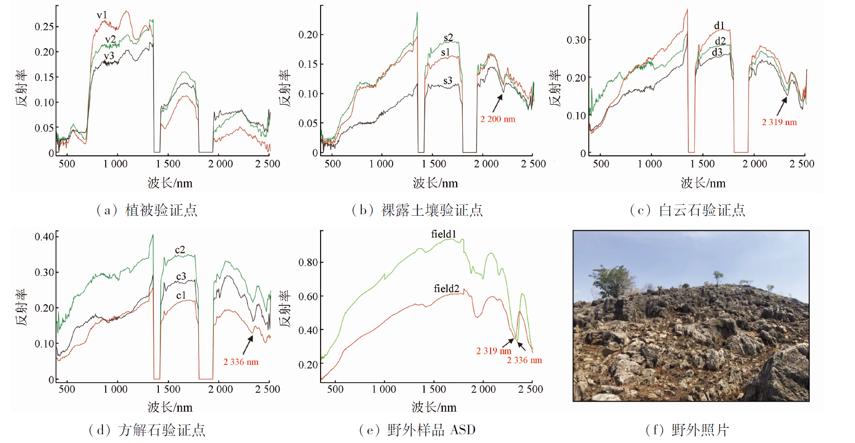
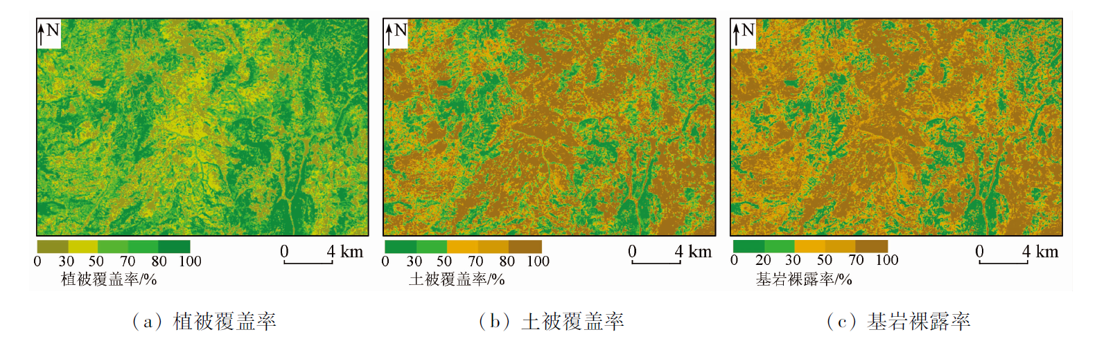
Rocky desertification is the primary eco-environmental problem in Karst mountainous areas in southwestern China. Scientific measures must be formulated to comprehensively promote the prevention and control of rocky desertification. Remote sensing technology, which enjoys the advantages of rapid positioning, wide coverage, and economic efficiency, has become an important technical method for investigating the spatial distribution of regional rocky desertification. Therefore, this study extracted three key indices used to characterize rocky desertification information (i.e., vegetation coverage, bedrock exposure rate, and soil coverage) of the study area using the pixel unmixing method based on GF-5 hyperspectral data and the spectral index method based on Landsat8 multispectral data. The results show that information on vegetation coverage can be accurately extracted from the two types of satellite remote sensing data. However, Landsat8 multispectral data are difficult to distinguish information about exposed bedrocks from that of bare soil due to their band setting and spectral resolution. By contrast, GF-5 hyperspectral data enable the direct and effective extraction of bedrock exposure rate and soil coverage, as well as the accurate identification of mineral components such as calcite and dolomite in exposed bedrocks. The results of this study can provide a scientific and effective technical and theoretical basis for the evaluation, classification, and comprehensive control of rocky desertification.
李娜, 甘甫平, 董新丰, 李娟, 张世凡, 李彤彤. 基于高分五号高光谱数据的石漠化调查应用研究[J]. 自然资源遥感, 2023, 35(2): 230-235.
LI Na, GAN Fuping, DONG Xinfeng, LI Juan, ZHANG Shifan, LI Tongtong. Investigation and applications of rocky desertification based on GF-5 hyperspectral data. Remote Sensing for Natural Resources, 2023, 35(2): 230-235.
Feng S N. Extraction of characterization factors of Karst rocky desertification based on multi terminal mixed pixel decomposition[D]. Beijing: China University of Mining and Technology (Beijing), 2015.
[2]
鞠建华, 戴传固. 岩溶石漠化遥感监测与防护规划[M]. 北京: 地质出版社, 2006.
Ju J H, Dai C G. Remote sensing monitoring and protection planning of Karst rocky desertification[M]. Beijing: Geological Publishing House, 2006.
[3]
Xie L W, Zhong J, Chen F F, et al. Evaluation of soil fertility in the succession of Karst rocky desertification using principal component analysis[J]. Solid Earth, 2015, 6(2):515-524.
doi: 10.5194/se-6-515-2015
[4]
Lian Y Q, You J Y, Lin K R, et al. Characteristics of climate change in southwest China Karst region and their potential environmental impacts[J]. Environmental Earth Sciences, 2015, 74(2):937-944.
doi: 10.1007/s12665-014-3847-8
[5]
Cao J H, Yuan D X, Tong L Q, et al. An overview of Karst ecosystem in Southwest China:Current state and future management[J]. Journal of Resource sand Ecology, 2015, 6 (4):247-256.
Chen Q W, Lan A J, Xiong K N, et al. Extraction of Karst rocky desertification information based on remote sensing spectral features[J]. Journal of Guizhou Normal University (Natural Science Edition), 2003(4):82-87.
Chen F, Zhou D Q, Bai X Y, et al. Temporal and spatial evolution and future scenario simulation of rocky desertification in typical Karst valley area[J]. Journal of Agricultural Resources and Environment, 2018, 35(2):174-180.
[8]
Benz U, Baatz M, Schreier G. OSCAR - object oriented segmentation and classification of advanced Radar allow automated information extraction[C]// 2001 International Geoscience and Remote Sensing Symposium (IGARSS), 2001:1913-1915.
Yue Y M, Zhang B, Wang K L, et al. Study on extraction of remote sensing evaluation factors of rocky desertification[J]. Journal of Remote Sensing, 2011, 15(4):722-736.
Yang S X, Zhang X, Shuai T, et al. Abundance estimation of Karst rocky desertification based on mixed pixel decomposition[J]. Remote Sensing Technology and Application, 2014, 29(5):823-832.
[11]
Nouri T, Oskouei M M. Processing of Hyperion data set for detection of indicative minerals using a hybrid method in Dost-Bayli,Iran[J]. International Journal of Remote Sensing, 2016, 37(19/20):4923-4947.
doi: 10.1080/01431161.2016.1225176
Li N, Dong X F, Gan F P, et al. Application of hyperspectral remote sensing technology in regional geological survey and mapping of bedrock area[J]. Geological Bulletin of China, 2021, 40(1):13-21.
Zhang G, He R S, Wang B, et al. Hydrogeological characteristics of Panxi Dalongtan in Huaning County,Yunnan Province[J]. Journal of Guizhou University(Natural Science Edition), 2020, 37(5):6.
Liu P, Wang Y, Liu Z B, et al. Distribution and regionalization of rocky desertification at county scale in Yunnan Province[J]. Journal of Zhejiang Agriculture and Forestry University, 2019, 36(5):965-973.
[16]
Dobigeon N, Tourneret J, Chang C. Semi-supervised linear spectral unmixing using a hierarchical Bayesian model for hyperspectral imagery[J]. IEEE Transactions on Signal Processing, 2008, 56(7):2684-2695.
doi: 10.1109/TSP.2008.917851
[17]
Keshava N, Mustard J F. Spectral unmixing[J]. IEEE Signal Processing Magazine, 2002, 19(1):44-57.
doi: 10.1109/79.974727
Jin X, Ke C Q. Monitoring of snow cover changes in Tianshan mountains based on mixed pixel decomposition[J]. Remote Sensing for Land and Resources, 2012, 24(4):146-151.doi:10.6046/gtzyyg.2012.04.24.
doi: 10.6046/gtzyyg.2012.04.24
[19]
Nalawade D B, Solankar M M, Surase R R, et al. Hyperspectral remote sensing image analysis with SMACC and PPI algorithms for endmember extraction[J]. Communications in Computer and Information Science, 2019, 1035:319-328
Wang R S, Yang S M, Yan B K. A review of mineral spectral identification methods and models with imaging spectrometer[J]. Remote Sensing for Land and Resources, 2007, 19(1):1-9.doi:10.6046/gtzyyg.2007.01.01.
doi: 10.6046/gtzyyg.2007.01.01
[21]
Rikmaru A. Landsat TM data processing guide for forest canopy density mapping and monitoring model[C]// ITTO Workshop on Utilization of Remote Sensing in Site Assessment and Planning for Rehabilitation of Logged-over Forest, 1996:1-8.
Pi M Q, Pan Z G. Geological factors affecting the formation and evolution of rocky desertification in Guizhou[J]. Broad Review of Scientific Stories (Scientific and Technological Exploration), 2014(4):84-85.
 2023, Vol. 35
  ), 甘甫平1(