Influence of urban rivers and their surrounding land on the surface thermal environment
FENG Xiaogang1(), ZHAO Yi2, LI Meng1, ZHOU Zaihui1, LI Fengxia1, WANG Yuan1, YANG Yongquan3
1. College of Architecture, Xi’an University of Architecture and Technology, Xi’an 710055, China 2. CCC Urban and Rural Construction Planning and Design Institute, Wuhan 430050, China 3. Shandong Province Metallurgical Engineering Co., Ltd., Jinan 250101, China
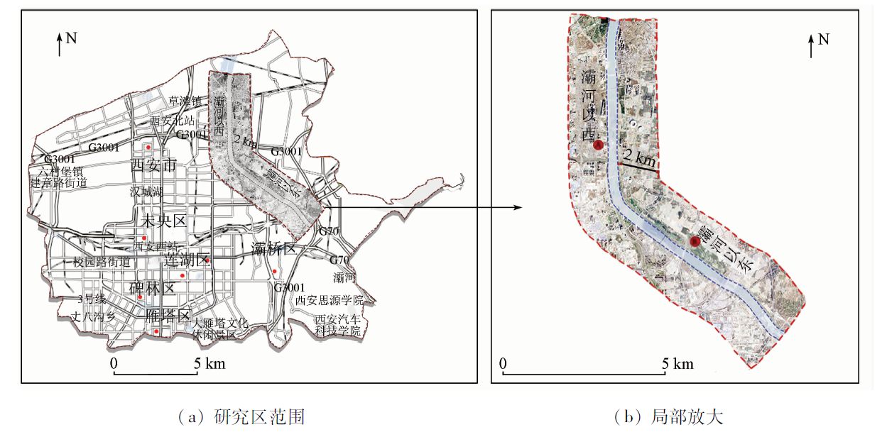
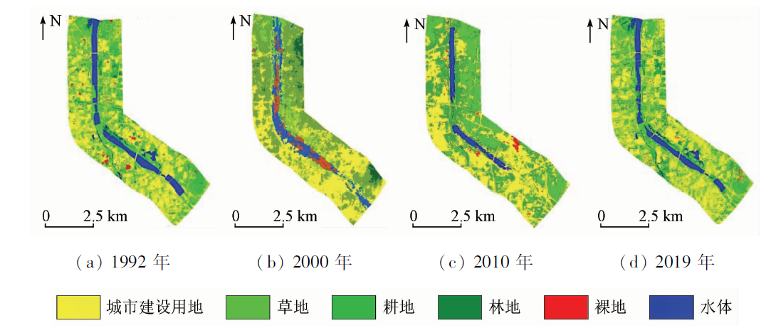
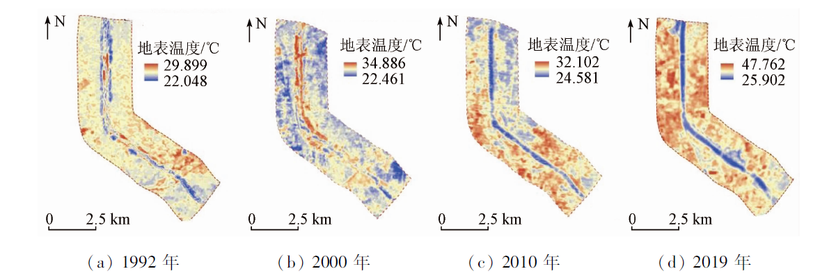
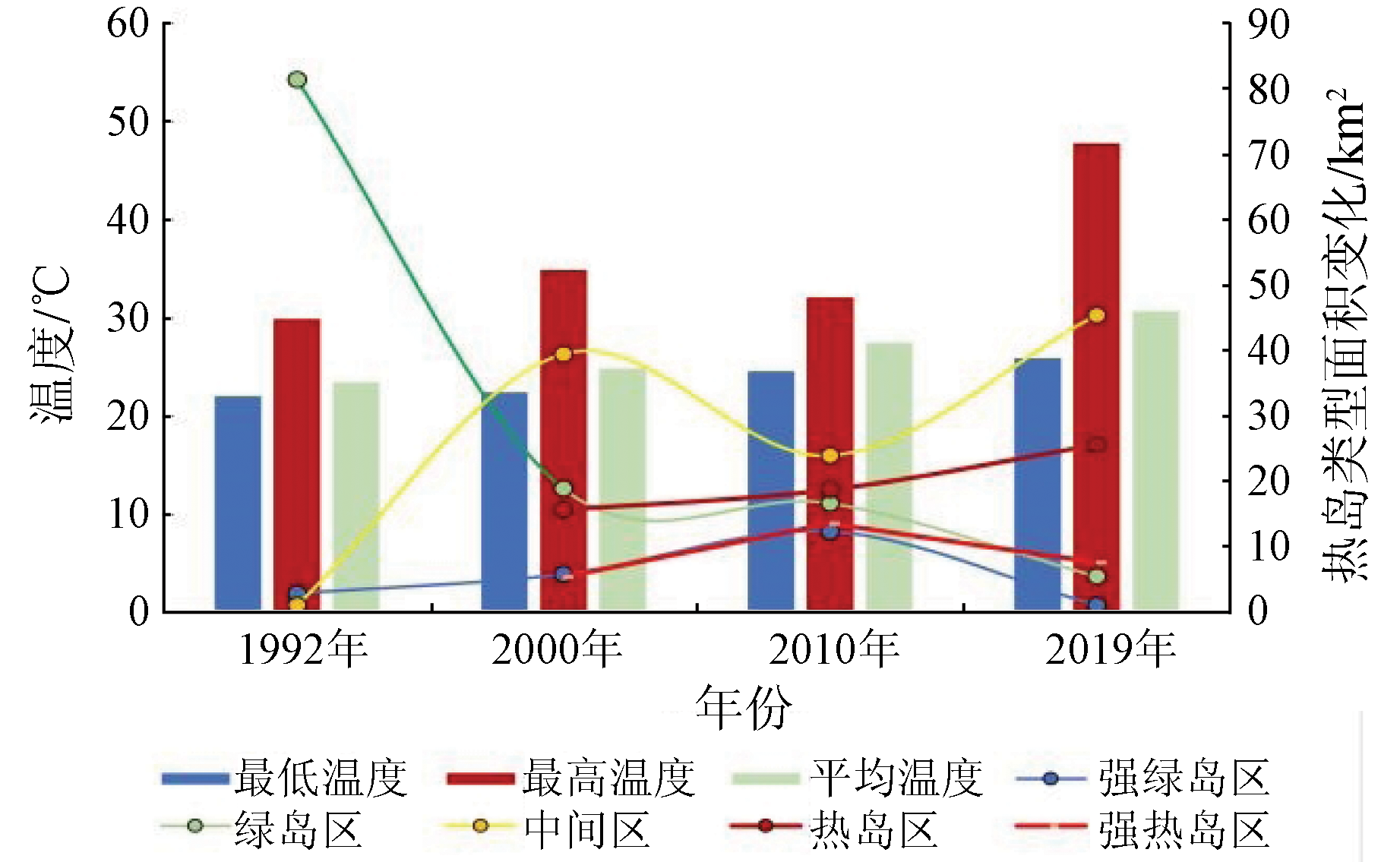
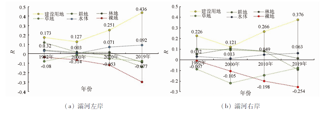
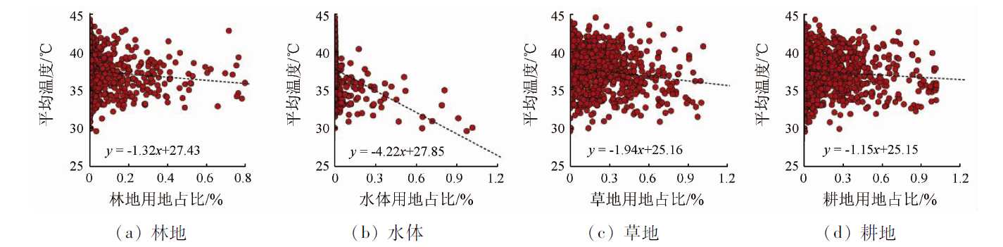
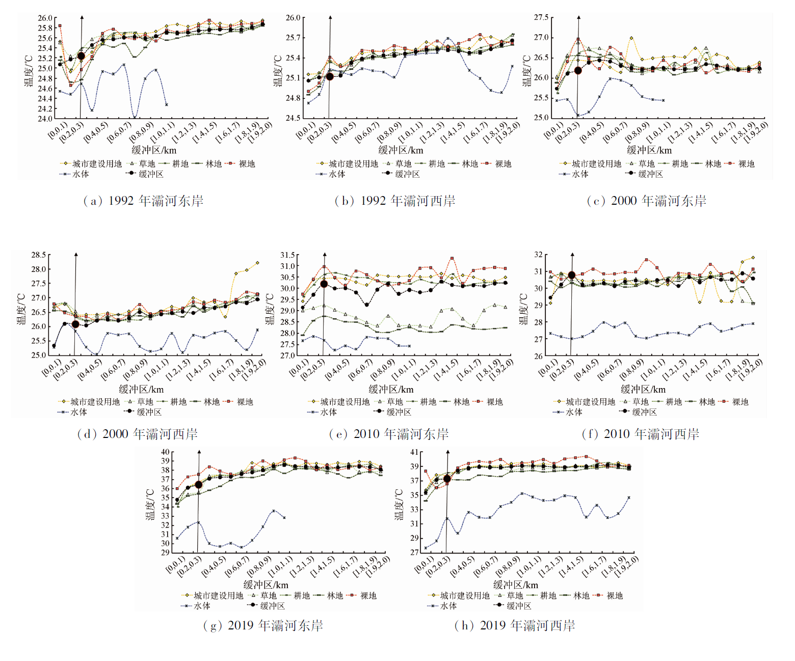
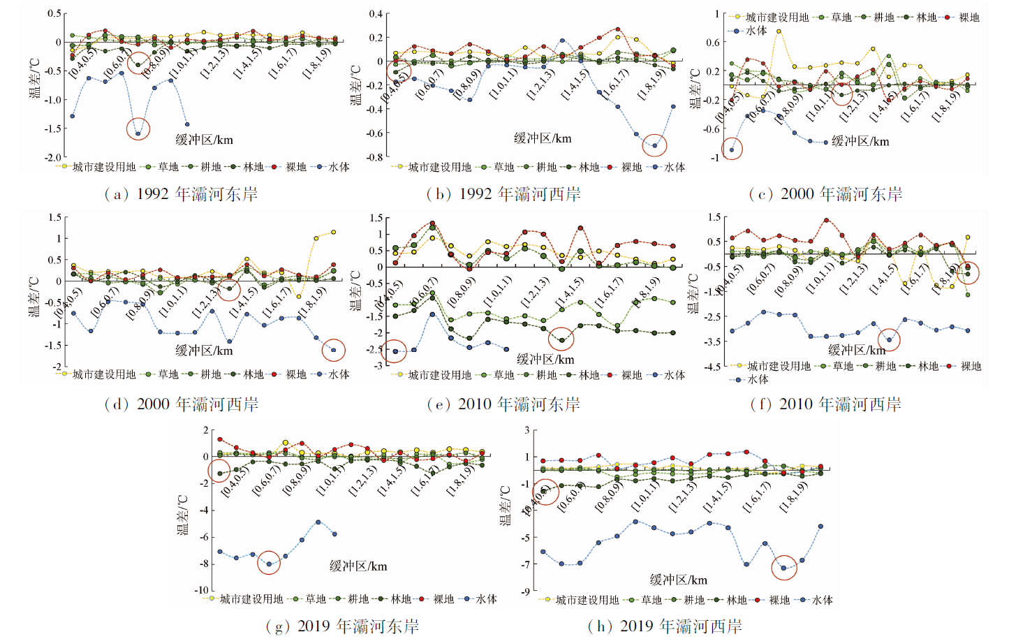
As an integral component of the urban ecosystem, water bodies hold considerable ecological significance for mitigating the urban heat island effect and the thermal environment of human habitat. With multi-temporal Landsat and SPOT data as experimental data, this study proposed a method for determining surface emissivity for mixed pixels based on the principle behind the construction of the support vector machine (SVM) optimal endmember subset. Then, this study employed the surface emissivity determination method to analyze the coupling relationship of the water bodies and surrounding land of the Bahe River with the surface temperature using a mono-window algorithm. The results are as follows: ① The SVM optimal endmember subset construction method for mixed pixels yielded an error of surface emissivity less than 0.005 (R = 0.832) relative to the MODIS LSE product. This result indicates that the method has high accuracy and thus can be used to extract surface emissivity. ② Over the past 27 years, the land types and local surface temperature patterns on both sides of the Bahe River have changed significantly, with a sharp increase in construction land and a significant warming trend. The effects of land use types surrounding the Bahe River on surface temperature varied in different periods, with construction land, grassland, water bodies, and forest land being the principal land use types affecting the thermal environment on both sides of the Bahe River. The cooling effects of water bodies, forest land, grassland, and cultivated land are in the order of water bodies > forest land > grassland > cultivated land. ③ The effects of land use types on both sides of the Bahe River on local temperatures exhibited spatial differences during the same period. To the east of the Bahe River, the water bodies, forest land, grassland, and cultivated land show significant cooling effects. In contrast, to the west of the river, only water bodies, forest land, and grassland showed significant cooling effects. This study contributes to the proper understanding of the influence of urban rivers on the local thermal environment, providing a scientific reference for mitigating the local thermal environment of urban rivers and their surrounding areas.
冯晓刚, 赵毅, 李萌, 周在辉, 李凤霞, 王园, 杨永佺. 城市河道及周临用地对地表热环境的影响研究[J]. 自然资源遥感, 2023, 35(3): 264-273.
FENG Xiaogang, ZHAO Yi, LI Meng, ZHOU Zaihui, LI Fengxia, WANG Yuan, YANG Yongquan. Influence of urban rivers and their surrounding land on the surface thermal environment. Remote Sensing for Natural Resources, 2023, 35(3): 264-273.
Feng X G, Zhou Z H, Li F X, et al. Spatiotemporal differentiation of thermal landscape pattern in Xianyang City driven by the integration of Xi’an and Xianyang[J]. Journal Xi’an University of Architecture and Technology (Natural Science Edition), 2021, 53(3): 413-420.
Feng Y Y, Hu T G, Zhang L X. Impacts of structure characteristics on the thermal environment effect of city parks[J]. Acta Ecologica Sinica, 2014, 34(12):3179-3187.
[5]
Lin Y, Wang Z F, Yang C, et al. Water as an urban heat sink: Blue infrastructure alleviates urban heat island effect in mega-city agglomeration[J]. Journal of Cleaner Production, 2020, 262:1-8.
[6]
Tan X Y, Sun X, Huang C D, et al. Comparison of cooling effect between green space and water body[J]. Sustainable Cities and Society, 2021, 67:1-11.
Liang B P, Ma Y F, Li H. Research on colling effect of landscape green space and urban water in Guilin City[J]. Ecology and Environmental Sciences, 2015, 24(2):278-285.
[8]
Du H Y, Song X J, Jiang H, et al. Research on the cooling island effects of water body: A case study of Shanghai,China[J]. Ecological Indicators, 2016, 67:31-38.
doi: 10.1016/j.ecolind.2016.02.040
[9]
Wu J S, Li C M, Zhang X, et al. Seasonal variations and main influencing factors of the water cooling islands effect in Shenzhen[J]. Ecological Indicators, 2020, 17:1470.
Zeng S P, Shi Z, Zhao M F, et al. The variation of buffer performance of water bodies on urban heat island along riverbank distance[J]. Acta Ecologica Sinica, 2020, 40(15): 5190-5202.
Zhang W, Wang K L, Liang S, et al. Research on the “Cold Island Effect” and scenario simulation of lakes in urban suburbs based on computational force fluid dynamics: Taking Tongsheng Lake in Changsha City as an example[J]. Ecology and Environmental Sciences, 2021, 30(10):2054-2066.
[12]
Zheng Y, Li Y, Hou H, et al. Quantifying the cooling effect and scale of large inner-city lakes based on landscape patterns: A case study of Hangzhou and Nanjing[J]. Remote Sensing, 2021, 13(8): 1526.
doi: 10.3390/rs13081526
Zhang X D, Zhao Y X, Ma F H, et al. Analysis on cooling effect of urban parks on urban thermal environment in Yinchuan City based on remote sensing[J]. Bulletin of Soil and Water Conservation, 2021, 41(5):338-347.
Wang Y B, Zhao Y H, Han L, et al. Coupling relationship of landscape pattern and urban heat island effect in Xi’an,China[J]. Chinese Journal of Applied Ecology, 2017, 28(8):2621-2628.
Hu L F, Xie Y L, Cui S Y, et al. The characteristics and driving forces of summer urban island in Guanzhong Plain urban agglomeration[J]. China Environmental Science, 2021, 41(8):3842-3852.
Huang L, Shao H, Zhang C Y, et al. Radiative transfer equation algorithm to retrieve Landsat8 sea surface temperature[J]. Journal of Applied Oceanography, 2021, 40(4):714-720.
Duan S B, Ru C, Li Z L, et al. Reviews of methods for land surface temperature retrieval from Landsat thermal infrared data[J]. National Remote Sensing Bulletin, 2021, 25(8):1591-1617.
doi: 10.11834/jrs.20211296
Qin Z H, Zhang M H, Arnon K, et al. Mono-window algorithm for retrieving land surface land temperature from Landsat TM6 data[J]. Acta Geo-Graphica Sinica, 2001(4):456-466.
Qin Z H, Li W J, Xu B, et al. Estimation method of land surface emissivity for retrieving land surface temperature from Landsat TM6 data[J]. Advances in Marine Science, 2004(22):129-137.
Song C Y, Qin Z H, Wang F. An effective method for LST decomposition based on the linear spectral mixing model[J]. Journal of Infrared and Millimeter Waves, 2015, 34(4):497-504.
Xu H Q. Change of Landsat8 TIRS calibration parameters and its effect on land surface temperature retrieval[J]. Journal of Remote Sensing, 2016, 20(2): 229-235.
Zhou J, Zhao Y P, Yue T X, et al. Near surface air temperature estimation by combining HASM with GWR model on a provincial scale[J]. Journal of Geo-Information Science, 2020, 22(10):2098-2107.
Ling D Q, Bi S B, Zuo Y, et al. Study on the comprehensive model construction of buffer analysis[J]. Science of Surveying and Mapping, 2019, 44(9):47-53.
Wang L X, Sun J H, Liu C, et al. Comparison of several different algorithms to retrieve land surface emissivity using Landsat8 data[J]. Journal of Xi’an University of Science and Technology, 2019, 39(2):327-333.
 2023, Vol. 35
  ), 赵毅2, 李萌1, 周在辉1, 李凤霞1, 王园1, 杨永佺3