NSCT-based change detection for high-resolution remote sensing images under the framework of change vector analysis in posterior probability space
SONG Jiaxin1(), LI Yikun1,2,3(), YANG Shuwen1,2,3, LI Xiaojun1,2,3
1. Faculty of Geomatics,Lanzhou Jiaotong University, Lanzhou 730070, China 2. National-Local Joint Engineering Research Center of Technologies and Applications for National Geographic State Monitoring, Lanzhou 730070, China 3. Gansu Provincial Engineering Laboratory for National Geographic State Monitoring, Lanzhou 730070, China
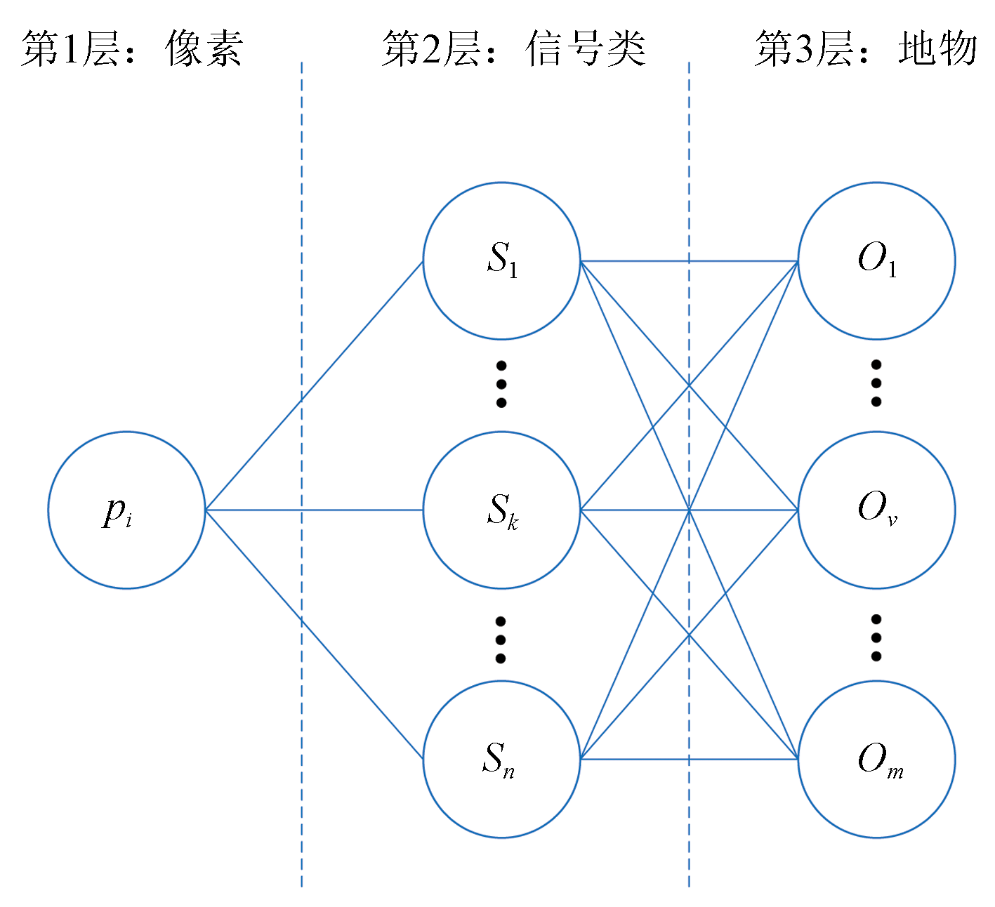
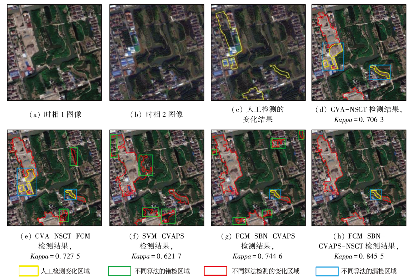
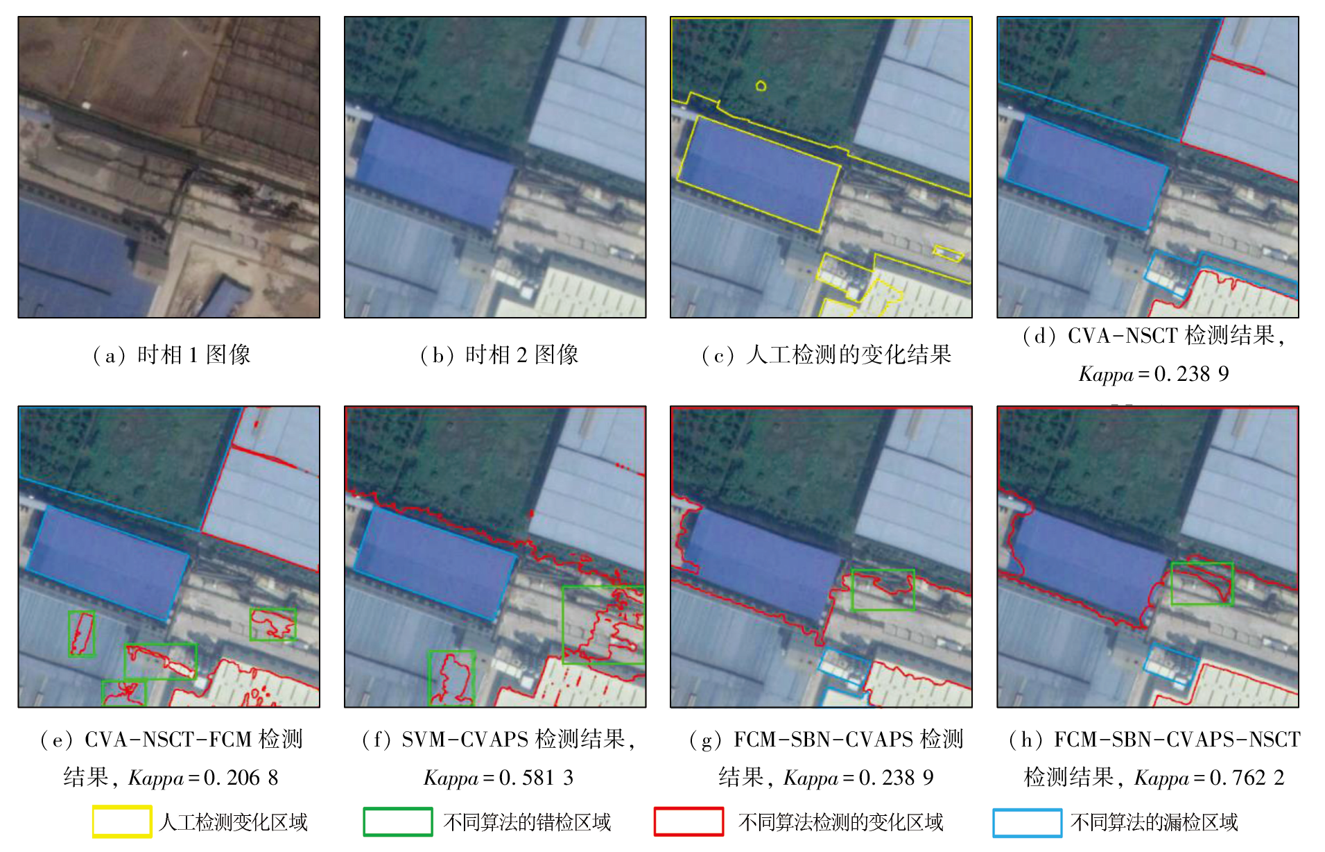
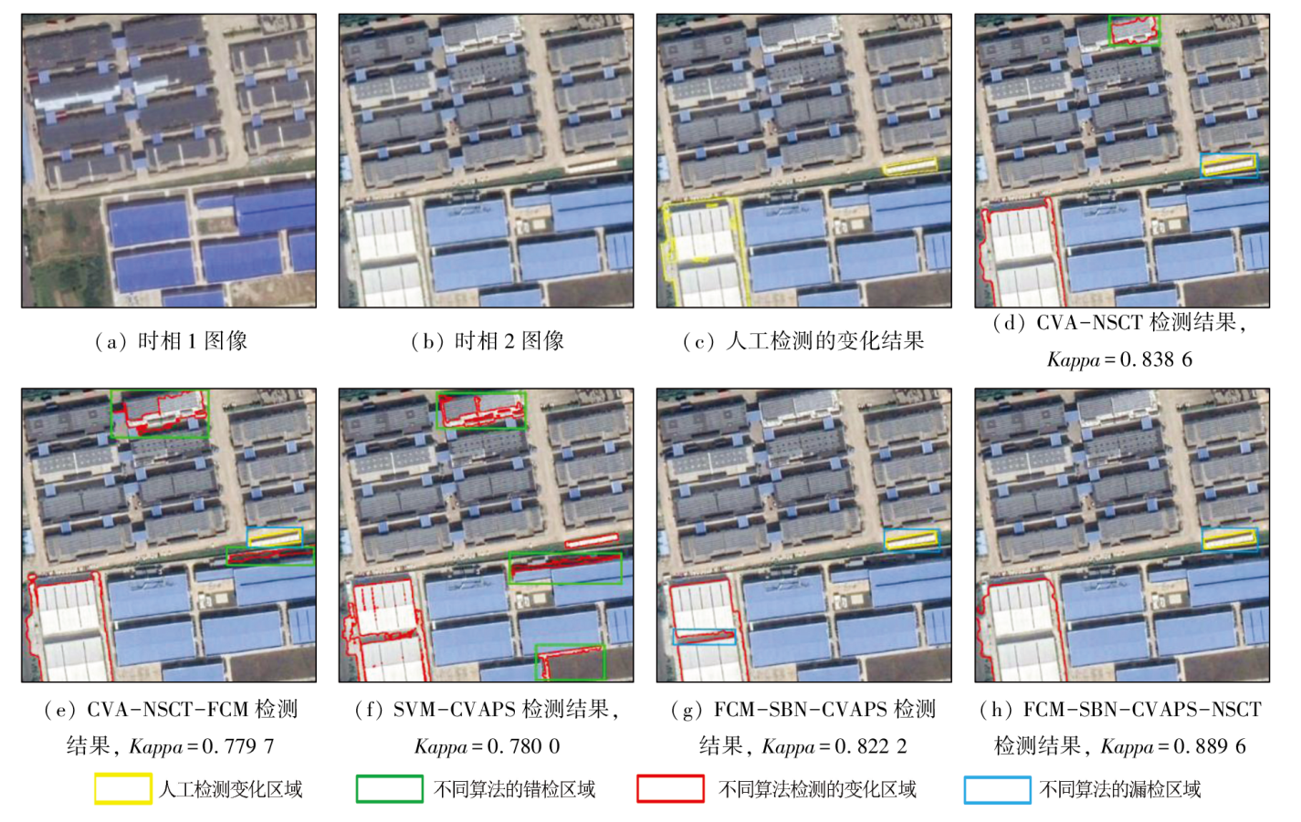
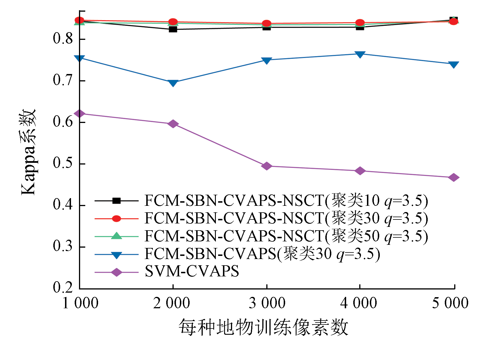
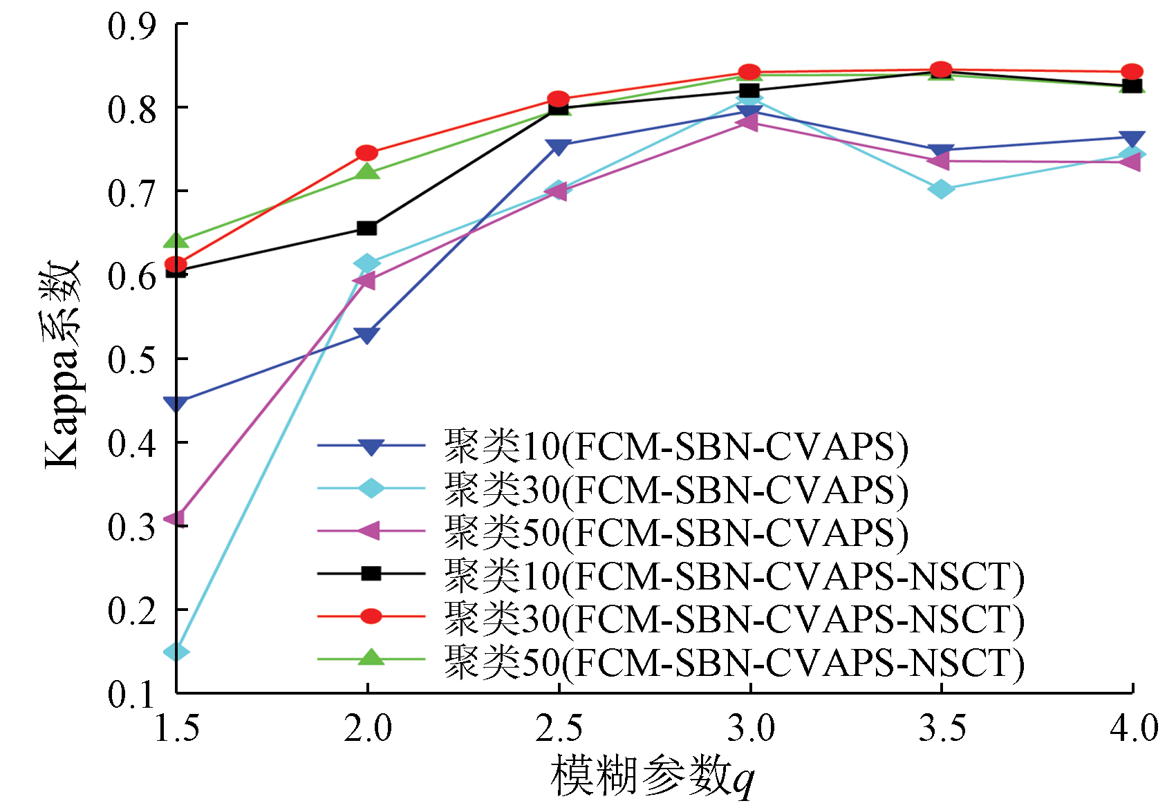
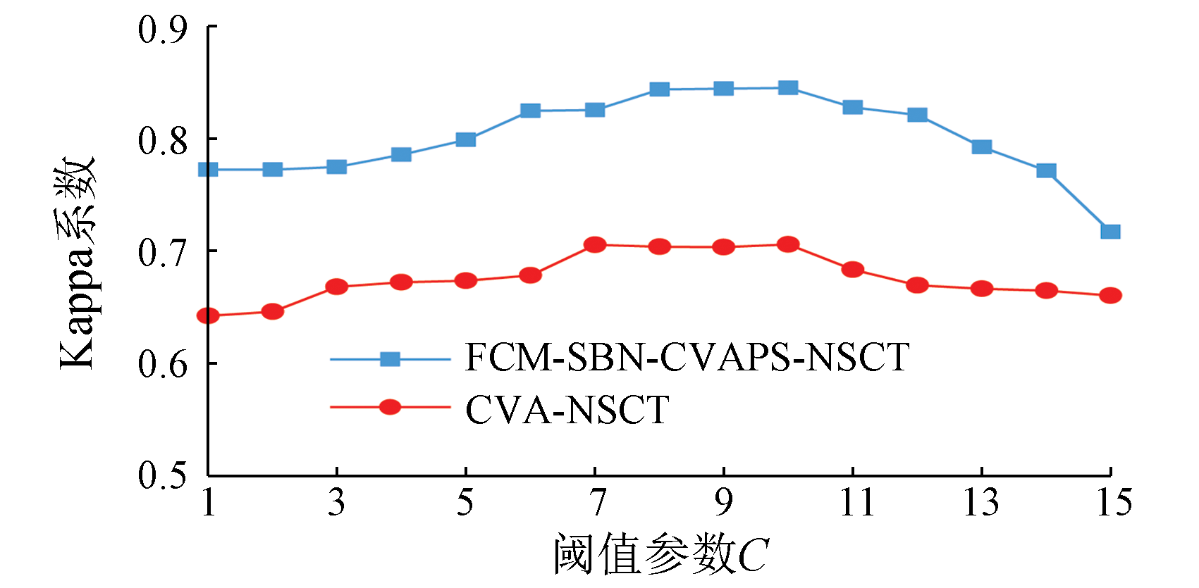
In the change detection for high-resolution remote sensing images, non-subsampled contourlet transform (NSCT) and change vector analysis (CVA) cannot ensure high detection accuracies under single thresholds due to significantly different changes in surface features. Hence, under the framework of change vector analysis in posterior probability space (CVAPS), this study proposed a NSCT-based change detection method combining fuzzy C-means (FCM) clustering and a simple Bayesian network (SBN): the FCM-SBN-CVAPS-NSCT method. First, the proposed method coupled FCM with an SBN to generate a change intensity map in posterior probability space. Then, the change intensity map was decomposed into submaps of different scales and directions through NSCT. The reconstructed change intensity map was optimized by preserving the details and eliminating noise in the high-frequency submaps. Finally, the multi-scale and multi-directional change detection in posterior probability space was achieved, enhancing the change detection accuracy. As indicated by the experimental results, the Kappa values obtained by the proposed method for three study areas were 0.100 9, 0.056 6, and 0.067 4 higher than those derived from the FCM-SBN-CVAPS method, demonstrating certain superiority.
宋嘉鑫, 李轶鲲, 杨树文, 李小军. 基于后验概率空间变化向量分析的NSCT高分辨率遥感影像变化检测[J]. 自然资源遥感, 2024, 36(3): 128-136.
SONG Jiaxin, LI Yikun, YANG Shuwen, LI Xiaojun. NSCT-based change detection for high-resolution remote sensing images under the framework of change vector analysis in posterior probability space. Remote Sensing for Natural Resources, 2024, 36(3): 128-136.
Yang C J, Ou X K, Dang C L, et al. Detecting the change information of forest vegetation in Lushui County of Yunnan Province[J]. Geo-information Science, 2000, 2(4):71-74,2.
[3]
Bruzzone L, Prieto D F. Automatic analysis of the difference image for unsupervised change detection[J]. IEEE Transactions on Geoscience and Remote Sensing, 2000, 38(3):1171-1182.
Li T H, Han P. Land use/cover change detection and analysis with remote sensing in Xiamen city[J]. Scientia Geographica Sinica, 2001, 21(6):537-543.
doi: 10.13249/j.cnki.sgs.2001.06.537
Yan Y, Liu Y L. Unsupervised remote sensing image change detection based on fusion and IFLICM algorithm[J]. Bulletin of Surveying and Mapping, 2018(3):25-31.
doi: 10.13474/j.cnki.11-2246.2018.0070
[6]
盛光伟. 基于角度优先变化向量分析的林地变化检测[D]. 南京: 南京大学, 2020.
Sheng G W. Forest change detection based on direction-first change vector analysis[D]. Nanjing: Nanjing University, 2020.
[7]
Li L, Li X, Zhang Y, et al. Change detection for high-resolution remote sensing imagery using object-oriented change vector analysis method[C]// 2016 IEEE International Geoscience and Remote Sensing Symposium (IGARSS).Beijing,China.IEEE, 2016:2873-2876.
[8]
Liu S, Bruzzone L, Bovolo F, et al. Sequential spectral change vector analysis for iteratively discovering and detecting multiple changes in hyperspectral images[J]. IEEE Transactions on Geoscience and Remote Sensing, 2015, 53(8):4363-4378.
[9]
Li S T, Fang L Y, Yin H T. Multitemporal image change detection using a detail-enhancing approach with nonsubsampled contourlet transform[J]. IEEE Geoscience and Remote Sensing Letters, 2012, 9(5):836-840.
[10]
Guo Q, Zhang J. Change detection for mutil-temporal remote sensing images based on NSCT and hierarchical clustering[C]// 2019 IEEE International Conference on Signal Processing,Communications and Computing (ICSPCC).Dalian,China.IEEE, 2019:1-4.
[11]
Sun Q, Gao Y. Unsupervised change detection in multitemporal SAR images via NSCT-domain feature clustering[C]// 2013 IEEE International Conference on Signal Processing,Communication and Computing (ICSPCC 2013).Kunming,China.IEEE, 2013:1-4.
Rabigul H, Jia Z H, Qin X Z, et al. Based on NSCT combination with FCM multitemporal remote sensing image change detection[J]. Laser Journal, 2014, 35(2):42-44.
[13]
Chen J, Chen X, Cui X, et al. Change vector analysis in posterior probability space:A new method for land cover change detection[J]. IEEE Geoscience and Remote Sensing Letters, 2011, 8(2):317-321.
[14]
Malila W A. Change vector analysis:An approach for detecting forest changes with landsat[J]. Proceedings of the Society of Photo-Optical Instrumentation Engineers, 1980:326-336.
Cai F S, Xiang Z J, Cai H, et al. CVA multi-scale remote sensing image change detection combined with feature selection[J]. Bulletin of Surveying and Mapping, 2020(8):101-104,130.
doi: 10.13474/j.cnki.11-2246.2020.0257
Long Y F, Qiao W Y, Sun J. Change detection of remote sensing images in datun mining area based on support vector machine[J]. Geomatics & Spatial Information Technology, 2020, 43(12):107-110,115.
Li Y K, Yang Y, Yang S W, et al. A change vector analysis in posterior probability space combined with fuzzy C-means clustering and a Bayesian network[J]. Remote Sensing for Natural Resources, 2021, 33(4):82-88.doi:10.6046/zrzyyg.2021032.
Lin M Z, Li Y K, An X L, et al. Remote sensing image retrieval based on the simple Bayesian network[J]. Journal of Yunnan University of Nationalities (Natural Sciences Edition), 2010, 19(1):67-70.
[19]
Otsu N. A threshold selection method from gray-level histograms[J]. IEEE Transactions on Systems,Man,and Cybernetics, 1979, 9(1):62-66.
[20]
DeGroot M H, Schervish M J. Probability and statistics[M]. Beijing: China Machine Press, 2021:495-506.
 2024, Vol. 36
  ), 李轶鲲1,2,3(