Application of multi-source remote sensing data in the exploration of sandstone-type uranium deposits: A case study of the Yingen area, Bayingebi basin
QIU Junting1(), LI Jiangkun2, GE Tengfei3, MU Hongxu1, RUI Xinmin1, YANG Yunhan1, YANG Yanjie1
1. Beijing Research Institute of Uranium Geology, Beijing 100029, China 2. Airborne Survey and Remote Sensing Center of Nuclear Industry, Shijiazhuang 050049, China 3. China Aero Geophysical Survey and Remote Sensing Center for Natural Resources, Beijing 100083, China
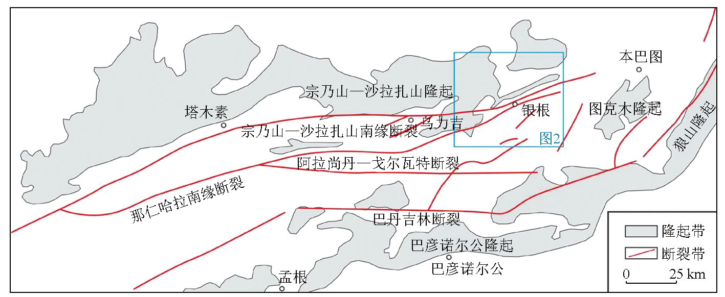
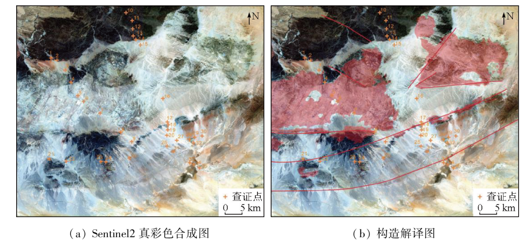
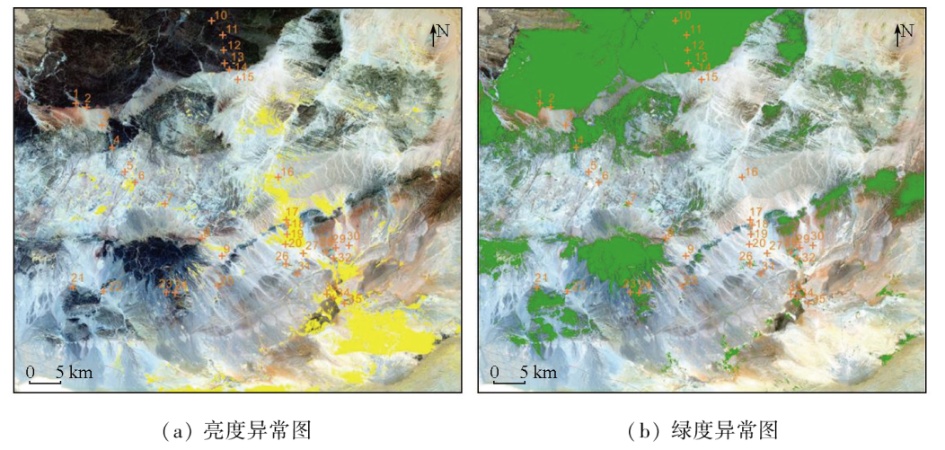
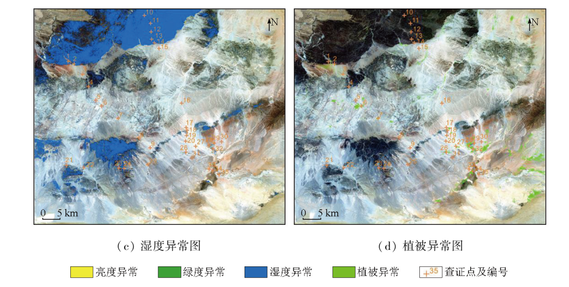
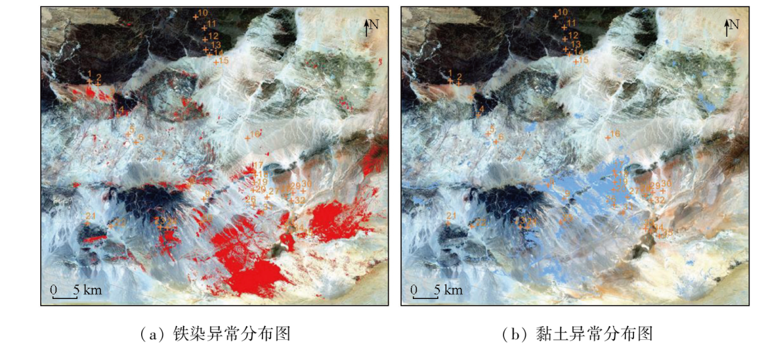
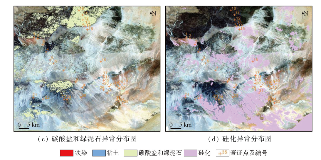
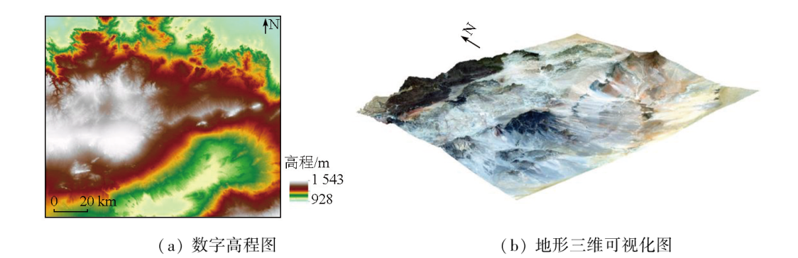
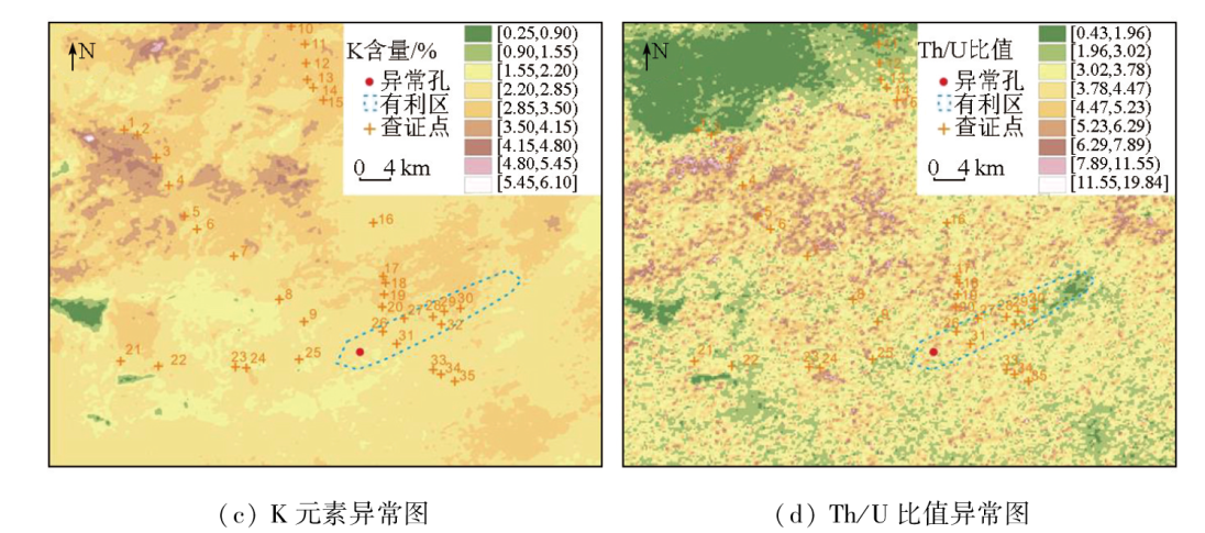
Sandstone-type uranium deposits emerge as important uranium resources, while remote sensing is identified as a vital method for mineral resource exploration. Since sandstone-type uranium deposits typically occur underground and tend to be covered by sediments, whether remote sensing can be effectively applied to the exploration of such deposits merits investigation. This study investigated the Yingen area in the Bayingobi basin. Utilizing multi-source remote sensing data from Sentinel2, Landsat7 ETM+, ASTER, ALOS DEM, and airborne radioactivity measurements, this study performed terrain visualization, structural interpretations, K-T transformation, NDVI index calculation, alteration mineral extraction, and Th/U ratio calculation. The results were then comprehensively analyzed from the perspective of the metallogenic model, metallogenic conditions, and ore-controlling factors of secondary reduced sandstone-type uranium deposits. The analytical results indicate that the Yingen area consists of an uplift zone in the center, a depression zone in the southeast, and a slope zone between them. The granitic rocks in the uplift zone are identified as significant sources of uranium. Multiple EW-trending faults in the slope zone facilitate the migration of uranium-bearing oxidized water underground. Additionally, the water-rich areas in the depression zone, combined with strong surface evaporation, create favorable conditions for the drainage and evaporation of uranium-bearing oxidized water, further promoting groundwater circulation. Therefore, the uplift zone, slope zone, and depression zone in the Yingen area form a complete circulation system for uranium-bearing oxidized water. In combination with previous data, this study holds that the slope zone might serve as a favorable area for the formation of secondary reduced sandstone-type uranium deposits. This study also demonstrates that even in seriously overburden areas, remote sensing can provide valuable guidance for uranium exploration by identifying metallogenic conditions and ore-controlling factors.
邱骏挺, 李江坤, 葛藤菲, 木红旭, 芮歆旻, 杨云汉, 杨燕杰. 多源遥感信息在砂岩型铀矿勘查中的应用——以巴音戈壁盆地银根地区为例[J]. 自然资源遥感, 2024, 36(4): 43-54.
QIU Junting, LI Jiangkun, GE Tengfei, MU Hongxu, RUI Xinmin, YANG Yunhan, YANG Yanjie. Application of multi-source remote sensing data in the exploration of sandstone-type uranium deposits: A case study of the Yingen area, Bayingebi basin. Remote Sensing for Natural Resources, 2024, 36(4): 43-54.
Luo Y, He Z B. Ore-forming condition analysis and uranium resource potential evaluation of sandstone-type uranium deposit in Bayin Gobi Basin,Inner Mongolia[R]. Beijing: Beijing Research Institute of Uranium Geology, 2009.
Zhang C Y, Nie F J, Hou S R, et al. Geological characteristics and uranium metallogenic model of Tamusu uranium deposit in Bayin Gobi Basin[J]. Geological Science and Technology Information, 2015, 34(1):140-147.
Sheng K F, Yang J X, Hou S R, et al. Uranium prospecting breakthrough,achievement expanding and prospecting orientation in main Mesozoic-Cenozoic sedimentary uranium basins of Inner Mongolia[J]. Geology in China, 2014, 41(4): 1304-1313.
Li P, Wang Q, Dai M J, et al. Geological characteristics and uranium metallogenic model of Tamusu uranium deposit in Bayin Gobi Basin[J]. Acta Mineralogica Sinica, 2017 (s1):479.
Peng Y B, Wang Q, Dai M J, et al. Ore body spatial distribution characteristics of TMS uranium deposit and prospecting prediction in Bayingebi basin[J]. World Nuclear Geoscience, 2018, 35(3): 131-136.
Mu H X, Ma T B, Guo Q, et al. Remote sensing identification of local drainage fault structures and uranium prospecting direction in the south of Songliao Basin[J]. Geology and Exploration, 2023, 59(1): 134-144.
Liu D C, Qiu J T, Yan B K, et al. Application of thermal inferred hyperspectral remote sensing in ore exploration[J]. Geological Review, 2018, 64(5): 1190-1200.
Liu D C, Tian F, Qiu J T, et al. Application of hyperspectral remote sensing in solid ore exploration in the Liuyuan-Fangshankou area[J]. Acta Geologica Sinica, 2017, 91(12):2781-2795.
Liu D C, Zhao Y J, Ye F W, et al. Study on the metallogenic background of the Liuyuan-Fangshankou area by using airborne hyperspectral remote sensing[J]. Journal of Remote Sensing, 2017, 21(1): 136-148.
Liu D C, Yan B K, Qiu J T. The Application of airborne hyper-spectral remote sensing technology to mineral resources exploration[J]. Acta Geoscientica Sinica, 2016, 37(3): 349-358.
Liu D C, Ye F W, Zhao Y J, et al. Airborne hyperspectral remote sensing for gold prospecting around Liuyuan-Fangshankou area,Gansu Province,China[J]. Journal of Geoinformation Science, 2015, 17(12):1545-1553.
Liu D C, Qiu J T, Tong Q L, et al. Airborne hyperspectral study of spatial relationship between oil and gas leakage and salinization in Jimusar area[J]. Geology in China, 2018, 45(5): 1062-1073.
[13]
Aita S K, Omar A E. Exploration of uranium and mineral deposits using remote sensing data and GIS applications,Serbal area,Southwestern Sinai,Egypt[J]. Arabian Journal of Geosciences, 2021, 14:2214.
[14]
dos Reis Salles R, de Souza Filho C R, Cudahy T, et al. Hyperspectral remote sensing applied to uranium exploration: A case study at the Mary Kathleen metamorphic-hydrothermal U-REE deposit,NW,Queensland,Australia[J]. Journal of Geochemical Exploration, 2017, 179:36-50.
[15]
Mariem M I, Amin B P, Hanafi B, et al. Lithological and alteration mapping using Landsat 8 and ASTER satellite data in the Reguibat Shield (West African Craton),North of Mauritania:Implications for uranium exploration[J]. Arabian Journal of Geosciences, 2021, 14:2576.
Li Z Y, Liu W S, Li W T, et al. Exudative metallogeny of the Hadatu sandstone-type uranium deposit in the Erlian Basin,Inner Mongolia[J]. Geology in China, 2022, 49(4):1009-1047.
Kang H, Chen Y, Li D, et al. Tracing and distinguishing geochemical anomalous sources in coverage area of Hadatu uranium deposit of Erlian Basin[J]. Uranium Geology, 2019, 35(06):351-358.
Liu D C, Shen J L, Qiu J T, et al. Geological analysis of Qianjiadian uranium deposit based on remote sensing technology[J]. Uranium Geology, 2018, 34(5): 314-320.
[19]
Jaireth S, McKay A, Lambert I. Association of large sandstone uranium deposits with hydrocarbons[J]. AusGeo News, 2008, 89:1-6.
[20]
Qiu J T, Mu H X, Yu X Q, et al. Identifying the principal factors controlling uranium enrichment: Semi-quantitative mineralogy and geochemistry of the sandstone-type Qianjiadian uranium deposit,northeast China[J]. Ore Geology Reviews, 2022, 144:104807.
Liu B, Shi Z Q, Peng Y B, et al. Geological characteristics and uranium metallogenic model of Tamusu uranium deposit in Bayin Gobi Basin[J]. Mineral Deposits, 2020, 39(1):168-183.
He Z B, Luo Y, Ma H F. Sedimentary facies characteristics of ore-bearing target horizon and its relationship to sandstone-type uranium mineralization in Bayingebi Basin[J]. World Nuclear Geoscience, 2010, 27(1):11-18.
Xiao G X, Li W H, Hou S W, et al. Controlling factors and genesis of Tamusu Uranium deposit in Bayingebi Basin,Inner Mongolia[J]. Global Geology, 2017, 36(4): 1124-1132.
Shi X J, Zhang L, Wang T, et al. Geochronology and geochemistry of the intermediate-acid intrusive rocks from Zongnaishan area in northern Alxa,Inner Mongolia,and their tectonic implications[J]. Acta Petrologica Et Mineralogica, 2014, 33(6): 989-1007.
Li P, Liu B, Ye M, et al. Constraints of Mesozoic- Cenozoic tectonic-sedimentary evolution on uranium mineralization and prospecting prediction in the Central and Southern Bayin Gobi Basin[J]. Geology in China, 2022, 49(2): 542-557.
[27]
Chen Q, Zhao Z, Zhou J, et al. ASTER and GF-5 satellite data for mapping hydrothermal alteration minerals in the Longtoushan Pb-Zn Deposit,SW China[J]. Remote Sensing, 2022, 14(5):1253.
 2024, Vol. 36
  ), 李江坤2, 葛藤菲3, 木红旭1, 芮歆旻1, 杨云汉1, 杨燕杰1