Distribution and rehabilitation status of lands destroyed by mining: A case study of Hebei Province
YE Lijuan1,2(), DUAN Xiaolong1,2, LI Ting1,2(), ZHANG Jing1,2, ZHANG Yun1,2, CHEN Donglei1,2
1. Tianjin Center, China Geological Survey(North China Center for Geoscience Innovation), Tianjin 300170, China 2. Tianjin Key Laboratory of Coast Geological Processes and Environmental Safety, Tianjin 300170, China
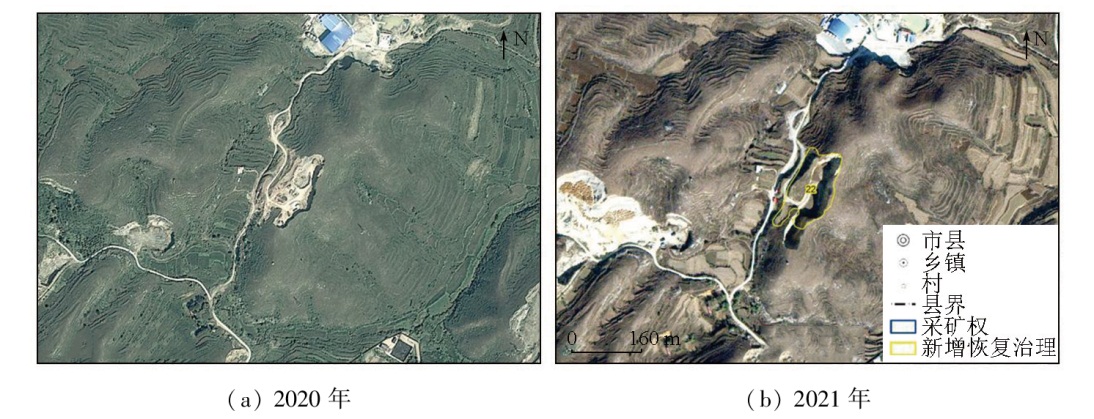
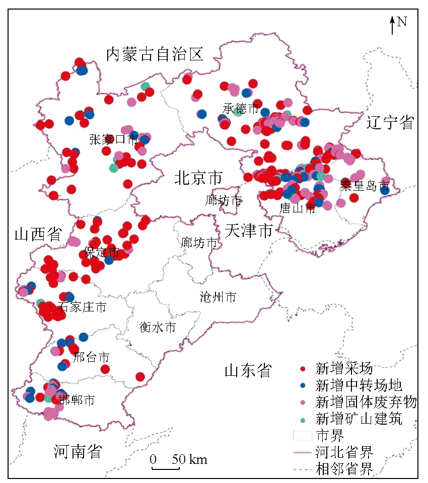
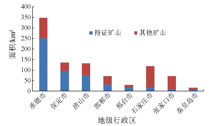
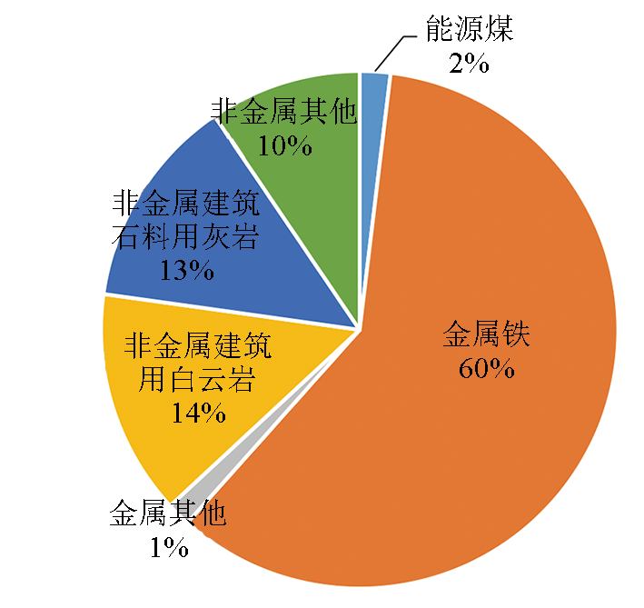
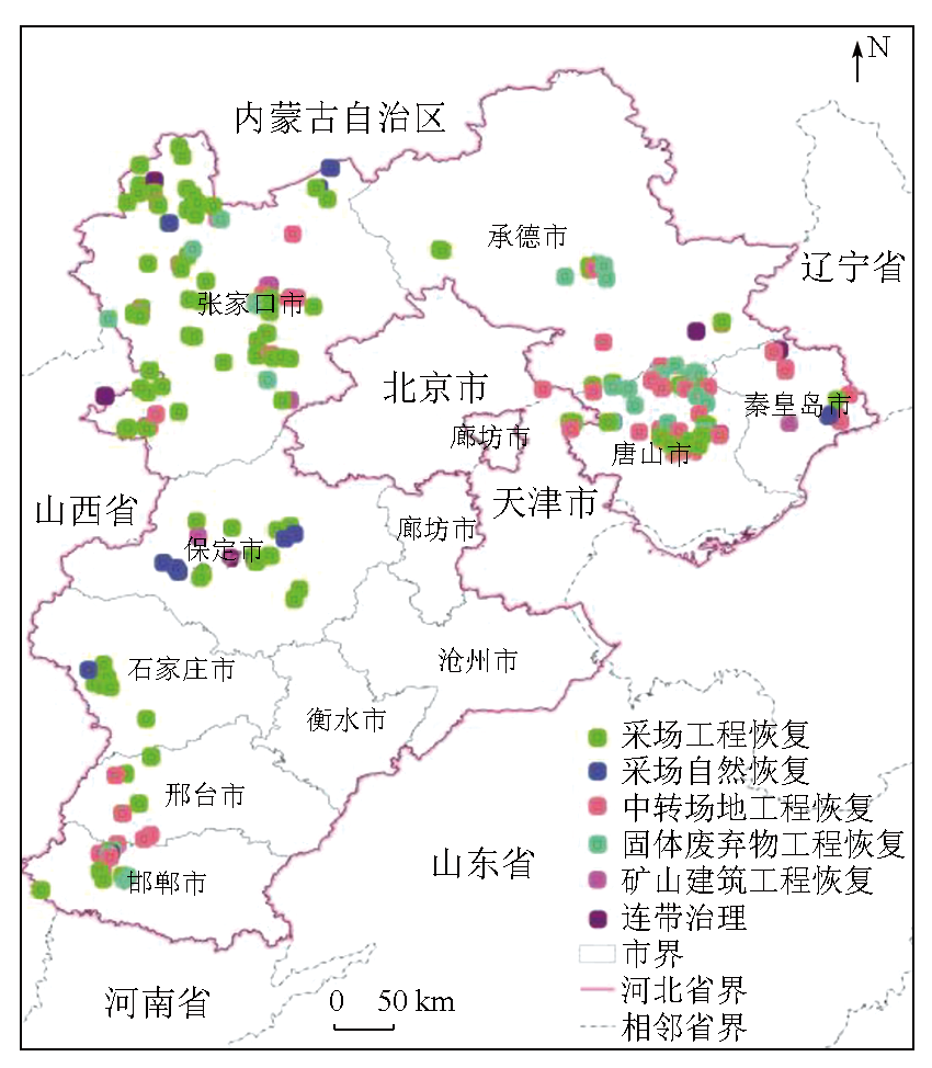
Remote sensing data with a high spatial resolution can be used to quickly ascertain the current status of the geological environment of mines in China, yielding objective and accurate results. By comparing 2020—2021 remote sensing images of 169 districts, counties, and cities in Hebei Province, 728 patches signaling suspected lands destroyed in mines were identified through interpretation. In 2021, the newly rehabilitated areas of the mining environment in Hebei Province reached 1 305.51 hm2, while the newly increased lands destroyed by mining were 932.13 hm2, resulting in a net increase of 373.38 hm2 in lands attributed to the geological environment rehabilitation. These results indicate the general achievement of mining while rehabilitating. Based on a preliminary analysis of the current status of the geological environment of mines in Hebei Province and existing primary issues, this study proposed countermeasures and recommendations for future rehabilitation efforts. The results of this study will provide foundational data and technical support for managing the geological environment of mines in Hebei Province and evaluating the effectiveness of mine greening initiatives.
叶丽娟, 段霄龙, 李婷, 张静, 张云, 陈东磊. 河北省采矿损毁土地分布及治理状况分析[J]. 自然资源遥感, 2024, 36(4): 75-81.
YE Lijuan, DUAN Xiaolong, LI Ting, ZHANG Jing, ZHANG Yun, CHEN Donglei. Distribution and rehabilitation status of lands destroyed by mining: A case study of Hebei Province. Remote Sensing for Natural Resources, 2024, 36(4): 75-81.
Wang Q M, Gao X. Research on the problems and countermeasures of green mine construction in Hebei Province[J]. Journal of Hebei Geo University, 2022 (3):108-111.
Gao J H, Zou L X, Long H, et al. Analysis on characteristics of mine geological environment and ecological restoration changes in Jilin Province based on dynamic remote sensing monitoring[J]. Remote Sensing for Natural Resources, 2022, 34(3):240-248.doi:10.6046/zrzyyg.2021278.
Tang J Q. Exploration and application of remote sensing information technology in natural resources monitoring and supervision[J]. Geomatics and Spatial Information Technology, 2022, 45 (10):38-40.
Qi S, Qiao W G, Zhang Y. Application of remote sensing in green mine environment monitoring in the Inner Mongolia Autonomous Region[J]. Bulletin of Surveying and Mapping, 2021 (1):79-82.
Yang J Z, Qin X W, Nie H F, et al. Comprehensive research in remote sensing monitoring of the national concentration zones of the important mine[J]. Geological Survey of China, 2015, 2(4):24-30.
Zheng X W, Peng B, Shang K. Assessment of the interpretation ability of domestic satellites in geological remote sensing[J]. Remote Sensing for Natural Resources, 2021, 33(3):1-10.doi:10.6046/zrzyyg.2020357.
Yang J Z, Xu J W, Yao W L, et al. Land destroyed by mining in China: Damage distribution,rehabilitation status and existing problems[J]. Earth Science Frontiers, 2021, 28(4):83-89.
Yu B W, Tian S F, Zhao Y C, et al. Application of GF-1 satellite in remote sensing monitoring on mine exploitation in Beijing and Tianjin[J]. Geoscience, 2017, 31(4):843-850.
Kong Z, Yang H T, Zheng F J, et al. Research advances in atmospheric correction of hyperspectral remote sensing images[J]. Remote Sensing for Natural Resources, 2022, 34(4):1-10.doi:10.6046/zrzyyg.2021371.
Liu H, Zhang Y, Huang X H, et al. Application of remote sensing technology in mining monitoring in midwest major mining area of Inner Mongolia[J]. North China Geology, 2021, 44(4):55-60.
Zhang X, Li W, Chen L, et al. Research progress and prospect of remote sensing-based feature extraction of opencast mining areas[J]. Remote Sensing for Natural Resources, 2023, 35(2):25-33.doi:10.6046/zrzyyg.2022141.
Jin Y L, Huang L X, Li X L. Application of remote sensing interpretation in production monitoring of mines[J]. Geomatics and Spatial Information Technology, 2022, 45(12):91-94.
Yang J Z, Nie H F, Jing Q Q. Preliminary analysis of mine geo-environment status and existing problems in China[J]. Remote Sensing for Land and Resources, 2017, 29(2):1-7.doi:10.6046/gtzyyg.2017.02.01.
Huang D M, Zhang C, Yao X J, et al. Research Progress of Mine Environment Remote Sensing Monitoring[J]. Remote Sensing Technology and Application, 2022, 37(5):1043-1055.
Wang J H, Li Y, Liang S N, et al. The study of land desertification recognition and extraction based on hyperspectral satellite data[J]. North China Geology, 2022, 45(4):61-67.
Wang R S, Xiong S Q, Nie H F, et al. Remote Sensing Technology and its Application in Geological Exploration[J]. Acta Geologica Sinica, 2011, 85(11):1699-1743.
He F, Liu R P, Xu Y N, et al. Monitoring and evaluation of mine geological environment in the Muli coal mining area based on remote sensing[J]. Geological Bulletin of China, 2018, 37(12):2251-2259.
 2024, Vol. 36
  ), 段霄龙1,2, 李婷1,2(