1. School of Environment and Spatial Informatics, China University of Mining and Technology, Xuzhou 221116, China 2. Jiangsu Key Laboratory of Coal-based Greenhouse Gas Control and Utilization, China University of Mining and Technology, Xuzhou 221008, Jiangsu, China 3. School of Geographical Sciences, Qinghai Normal University, Xining 810008, China 4. School of Atmospheric Sciences, Nanjing University, Nanjing 210023, China 5. Jiangsu CYP Light Heat Electronics Industrial Technology Research Insitute, Ltd., Xuzhou 221116, China
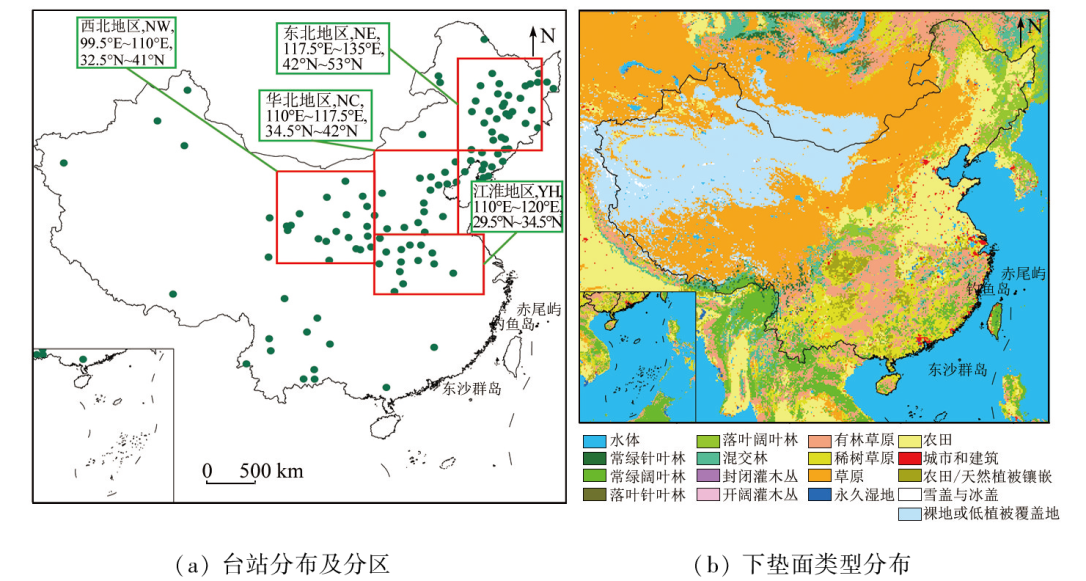
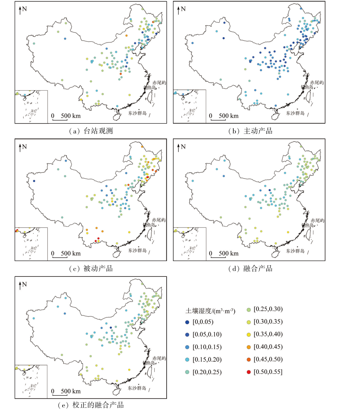
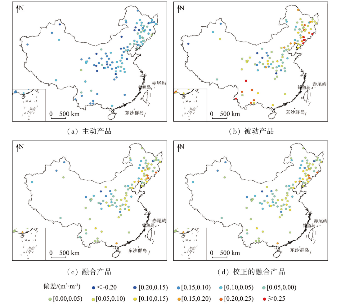
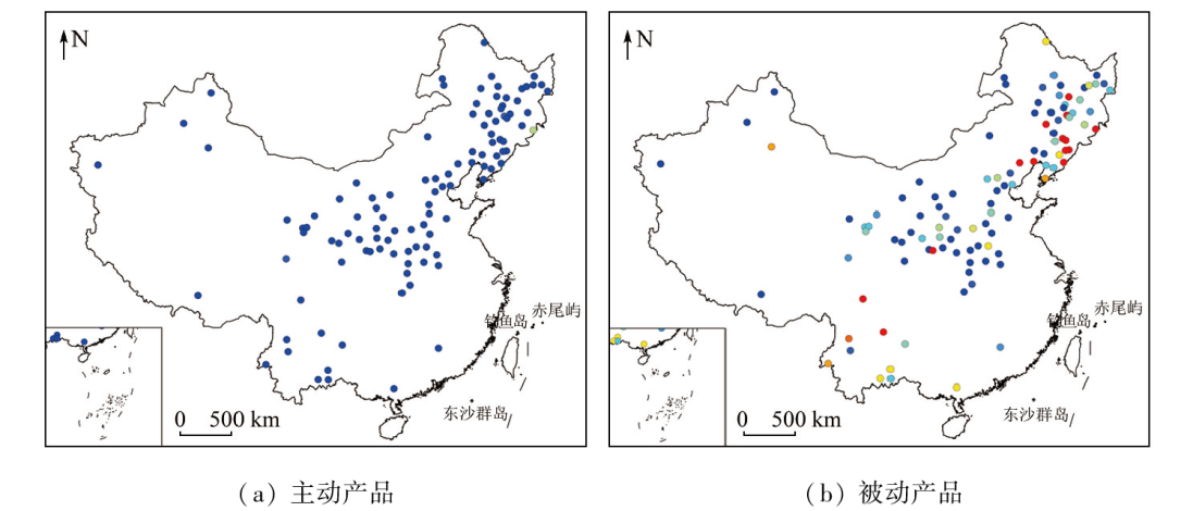
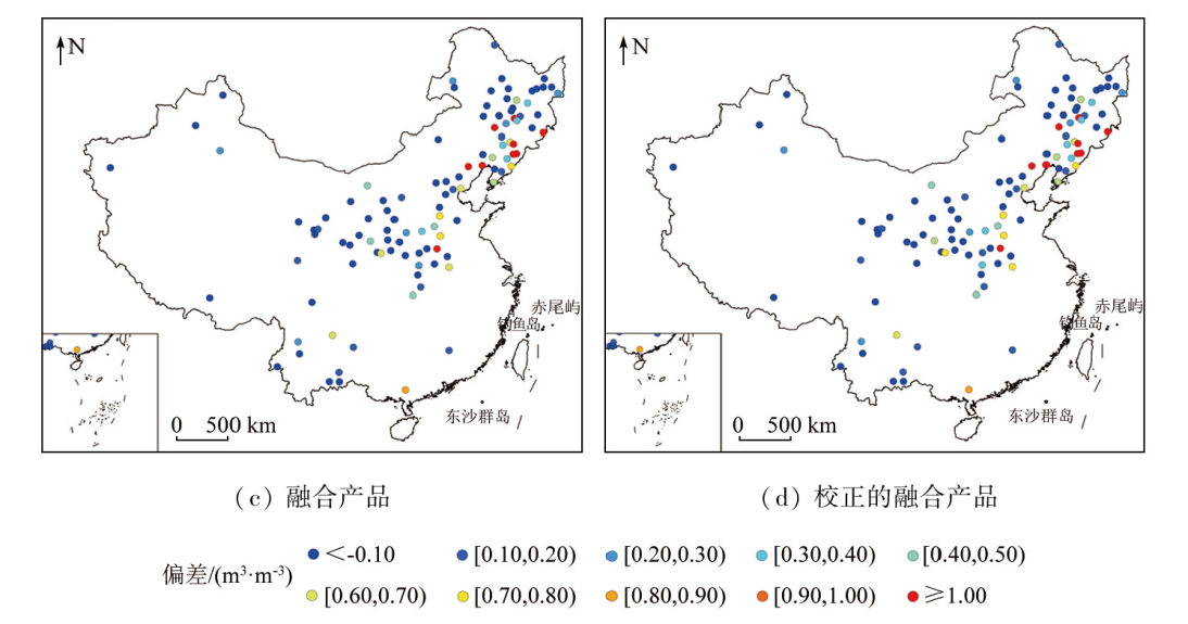
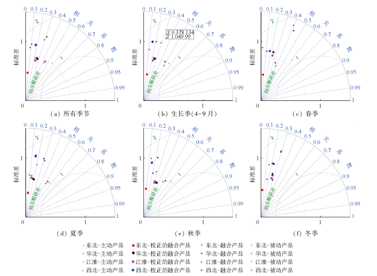
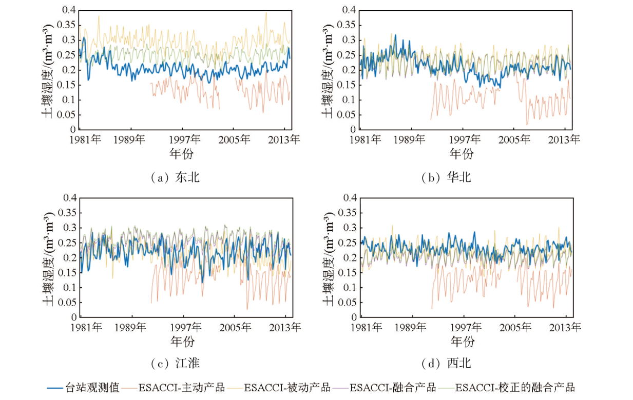
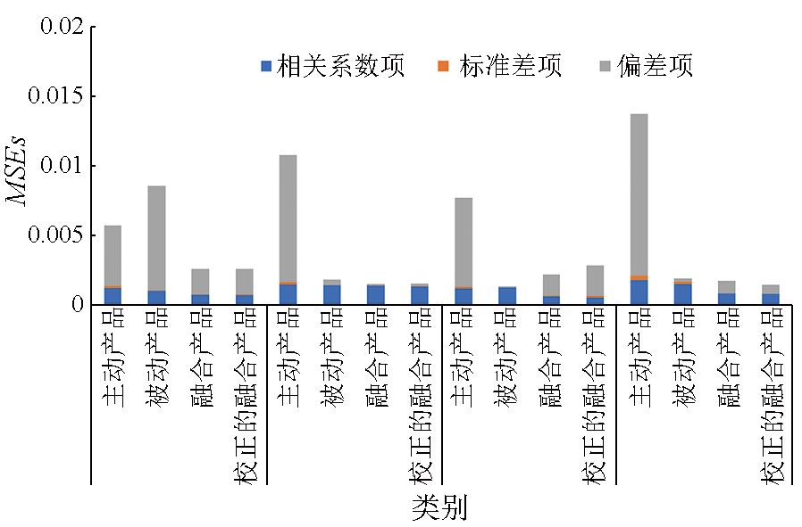
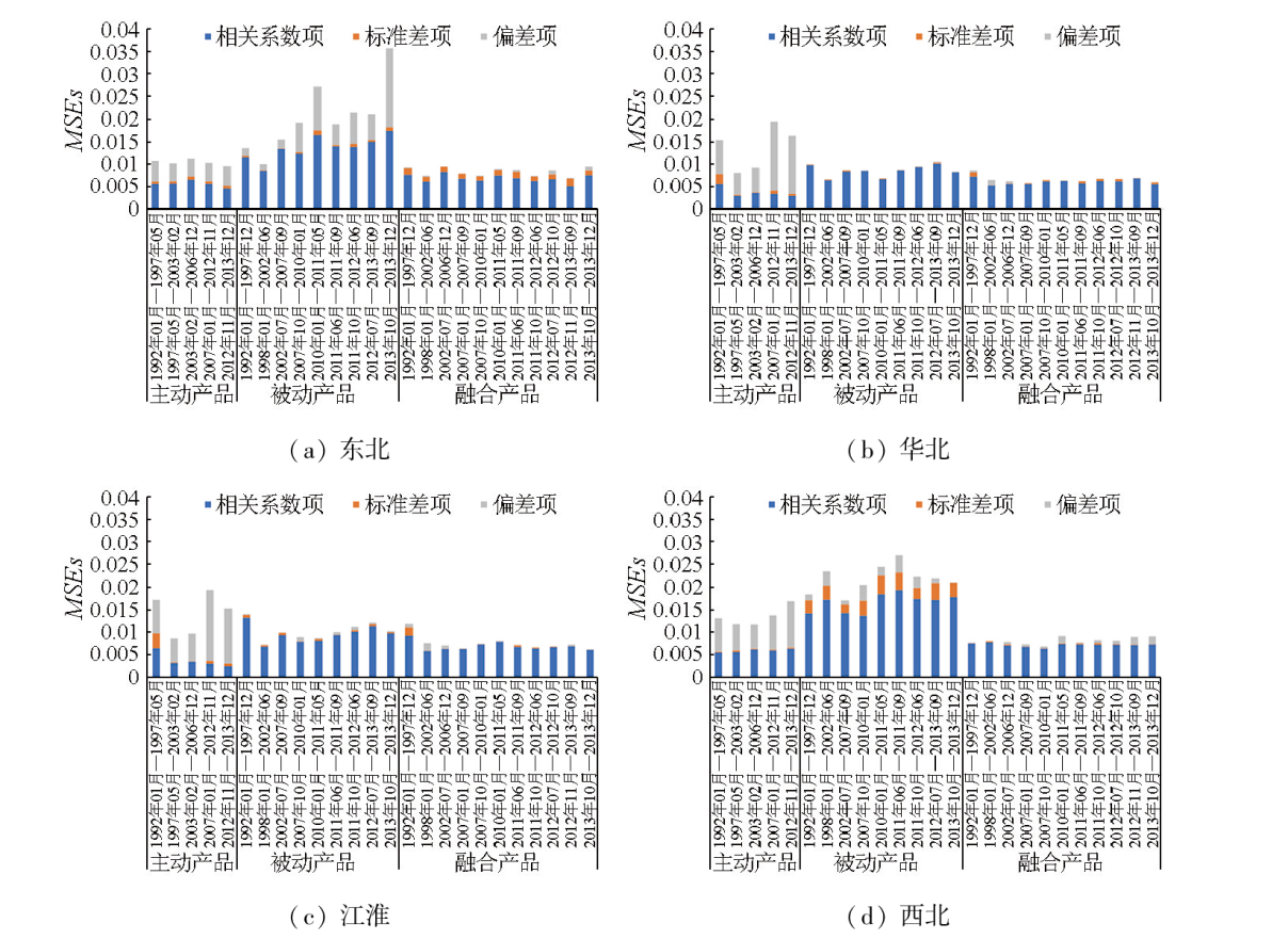
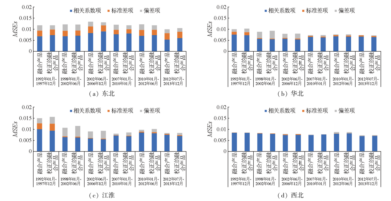
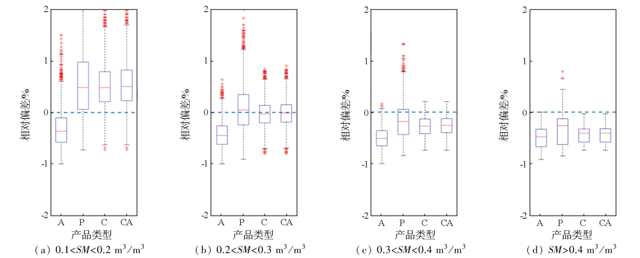
Soil moisture products based on remote sensing are crucial for investigating climatic change and hydrological effects on a regional scale. However, there is a lack of verification and application of long-term soil moisture datasets in China due to factors such as inconsistent observation standards and instrument upgrades. Using the agro-meteorological dataset from the China Meteorological Administration and soil moisture data from the International Soil Moisture Network (ISMN), this study constructed a monthly dataset of soil moisture in eastern China covering the period from 1981 to 2013. Accordingly, this study analyzed and compared the performance of four microwave remote sensing-based soil moisture products developed by the European Space Agency’s Climate Change Initiative (ESA CCI): active, passive, combined, and combined adjusted products. The results indicate that active and passive products underestimated and overestimated soil moisture in eastern China, respectively. The maximum deviations from active products were found in the northern and northwestern regions, with relative deviations of -30.9% and -29.6%, respectively. In contrast, the passive products showed relative deviations of 39.1% and 26.5%, respectively for soil moisture in northeastern and northwestern regions. The combined products mitigated the underestimation of the active products and the overestimation of the passive product in these regions, reducing the relative deviations to 24.3% and 3.7%, respectively. Regarding the variation characteristics of regional monthly average soil moisture, both the active and combined products performed best for soil moisture in the Yangtze-Huaihe (YH) region, with the highest correlation coefficient of 0.66. The passive and combined products yielded correlation coefficients of 0.44 and 0.47, respectively for soil moisture in the northeastern region and performed poorly for soil moisture in the northern and northwestern regions. The analysis of the variance sources of the remote sensing-based products indicates that the active products enjoyed more advantages in describing the evolutionary characteristics of soil moisture, the passive products demonstrated greater accuracy, and the combined products yielded the highest accuracy overall. Additionally, this study investigated the impacts of changes in the integrated satellite equipment of CCI on product performance. The results indicate that the active products exhibited consistent performance for soil moisture in the northeastern and northwestern regions in different periods. However, passive sensors still exhibited gaps in reproducing the variations in soil moisture. The combined products exhibited better overall variance than both active and passive products. However, these products yielded comparable correlation coefficients with the active products for soil moisture in the northeastern and northwestern regions. The combined products presented no notable improvement after correction, proving that it is feasible to conduct long-term research using the combined products of CCI. The results of this study contribute to a deeper understanding of the error structures and characteristics of various satellite product datasets, providing evidence for researchers to select appropriate data products and conduct research on long time series.
Dirmeyer P A. Using a global soil wetness dataset to improve seasonal climate simulation[J]. Journal of Climate, 2000, 13(16):2900-2922.
[2]
Koster R D, Dirmeyer P A, Guo Z, et al. Regions of strong coupling between soil moisture and precipitation[J]. Science, 2004, 305(5687):1138-1140.
pmid: 15326351
[3]
McColl K A, Wang W, Peng B, et al. Global characterization of surface soil moisture drydowns[J]. Geophysical Research Letters, 2017, 44(8):3682-3690.
Guo W D, Ma Z G, Wang H J. Soil moisture—An important factor of seasonal precipitation prediction and its application[J]. Climatic and Environmental Research, 2007, 12(1):20-28.
[5]
Komma J, Blöschl G, Reszler C. Soil moisture updating by Ensemble Kalman Filtering in real-time flood forecasting[J]. Journal of Hydrology, 2008, 357(3-4):228-242.
[6]
Seneviratne S I, Corti T, Davin E L, et al. Investigating soil moisture-climate interactions in a changing climate:A review[J]. Earth-Science Reviews, 2010, 99(3-4):125-161.
Zhang W J, Zhou T J, Zhi H. A numerical experiment on the effect of soil moisture to summer climate over China[J]. Acta Meteorologica Sinica, 2012, 70(1):78-90.
[8]
Dorigo W A, Wagner W, Hohensinn R, et al. The international soil moisture network:A data hosting facility for global in situ soil moisture measurements[J]. Hydrology and Earth System Sciences, 2011, 15(5):1675-1698.
[9]
Dorigo W, Himmelbauer I, Aberer D, et al. The international soil moisture network:Serving earth system science for over a decade[J]. Hydrology and Earth System Sciences, 2021, 25(11):5749-5804.
[10]
Lawrence D M, Oleson K W, Flanner M G, et al. Parameterization improvements and functional and structural advances in version 4 of the Community Land Model[J]. Journal of Advances in Modeling Earth Systems, 2011, 3:M03001.
[11]
Xue Y, Sellers P J, Kinter J L, et al. A simplified biosphere model for global climate studies[J]. Journal of Climate, 1991, 4(3):345-364.
[12]
Kalnay E, Kanamitsu M, Kistler R, et al. The NCEP/NCAR 40-year reanalysis project[J]. Bulletin of the American Meteorological Society, 1996, 77(3):437-472.
Shi C X, Xie Z H, Qian H, et al. China land soil moisture EnKF data assimilation based on satellite remote sensing data[J]. Scientia Sinica Terrae, 2011, 41(3):375-385.
[14]
Kanamitsu M, Ebisuzaki W, Woollen J, et al. NCEP-DOE AMIP-II reanalysis (R-2)[J]. Bulletin of the American Meteorological Society, 2002, 83(11):1631-1643.
[15]
Mitchell K E, Lohmann D, Houser P R, et al. The multi-institution North American Land Data Assimilation System (NLDAS):Utilizing multiple GCIP products and partners in a continental distributed hydrological modeling system[J]. Journal of Geophysical Research:Atmospheres, 2004, 109:D07S90.
[16]
Rodell M, Houser P R, Jambor U, et al. The global land data assimilation system[J]. Bulletin of the American Meteorological Society, 2004, 85(3):381-394.
[17]
Dee D P, Uppala S M, Simmons A J, et al. The ERA-Interim reanalysis:configuration and performance of the data assimilation system[J]. Quarterly Journal of the Royal Meteorological Society, 2011, 137(656):553-597.
[18]
Xia Y, Mitchell K, Ek M, et al. Continental-scale water and energy flux analysis and validation for North American Land Data Assimilation System Project phase 2 (NLDAS-2):2.Validation of model-simulated streamflow[J]. Journal of Geophysical Research:Atmospheres, 2012, 117:D03109.
Chen S L, Liu Y B, Wen Z M. Satellite retrieval of soil moisture:An overview[J]. Advances in Earth Science, 2012, 27(11):1192-1203.
[20]
Liu W, Wang J, Xu F, et al. Validation of four satellite-derived soil moisture products using ground-based in situ observations over northern China[J]. Remote Sensing, 2022, 14(6):1419.
Wang Y N, An R, You J J, et al. Downscaling and merging of the CCI soil moisture product over China[J]. Journal of Hohai University (Natural Sciences), 2018, 46(3):196-202.
Yao X L, Yu J S, Li Z J, et al. Accuracy evaluation of the ESA CCI remote sensing soil moisture for revealing drought in Northeast China[J]. Journal of Beijing Normal University (Natural Science), 2019, 55(2):233-239.
Li A, Lu Q F, Yang X F, et al. AMSR-E soil moisture compared with ECWMF and NECP soil moisture[J]. Remote Sensing Technology and Application, 2013, 28(4):666-673.
Li M X, Ma Z G, Niu G Y. Modeling spatial and temporal variations in soil moisture in China[J]. Chinese Science Bulletin, 2011, 56(16):1288-1300.
[25]
Ling X, Huang Y, Guo W, et al. Comprehensive evaluation of sate-llite-based and reanalysis soil moisture products using in situ observations over China[J]. Hydrology and Earth System Sciences, 2021, 25(7):4209-4229.
Zhu Z, Shi C X, Zhang T, et al. Applicability analysis of four soil moisture reanalysis datasets in China[J]. Plateau Meteorology, 2018, 37(1):240-252.
doi: 10.7522/j.issn.1000-0534.2017.00033
[28]
Albergel C, de Rosnay P, Gruhier C, et al. Evaluation of remotely sensed and modelled soil moisture products using global ground-based in situ observations[J]. Remote Sensing of Environment, 2012, 118:215-226.
[29]
Chen Y Y, Yang K, Qin J, et al. Evaluation of SMAP,SMOS,and AMSR2 soil moisture retrievals against observations from two networks on the Tibetan Plateau[J]. Journal of Geophysical Research:Atmospheres, 2017, 122(11):5780-5792.
[30]
An R, Zhang L, Wang Z, et al. Validation of the ESA CCI soil moisture product in China[J]. International Journal of Applied Earth Observation and Geoinformation, 2016, 48:28-36.
[31]
González-Zamora Á, Sánchez N, Pablos M, et al. CCI soil moisture assessment with SMOS soil moisture and in situ data under different environmental conditions and spatial scales in Spain[J]. Remote Sensing of Environment, 2019, 225:469-482.
[32]
Dorigo W, Wagner W, Albergel C, et al. ESA CCI Soil Moisture for improved earth system understanding:State-of-the art and future directions[J]. Remote Sensing of Environment, 2017, 203:185-215.
[33]
Gruber A, Scanlon T, van der Schalie R, et al. Evolution of the ESA CCI soil moisture climate data records and their underlying merging methodology[J]. Earth System Science Data, 2019, 11(2):717-739.
[34]
Friedl M, Sulla-Menashe D. MCD12C1 MODIS/Terra+Aqua Land Cover Type Yearly L3 Global 0.05Deg CMG V006 [Data set].NASA EOSDIS Land Processes Distributed Active Archive Center.Accessed 2023-01-19 from https://doi.org/10.5067/MODIS/MCD12C1.006.
[35]
Gupta H V, Kling H, Yilmaz K K, et al. Decomposition of the mean squared error and NSE performance criteria:Implications for improving hydrological modelling[J]. Journal of Hydrology, 2009, 377(1/2):80-91.
[36]
Dorigo W A, Scipal K, Parinussa R M, et al. Error characterisation of global active and passive microwave soil moisture datasets[J]. Hydrology and Earth System Sciences, 2010, 14(12):2605-2616.
[37]
Conrad V, Pollak L W. Methods in climatology[J]. Quarterly Journal of the Royal Meteorology Society, 1951, 77(332):328-330.
[38]
Peterson T C, Easterling D R, Karl T R, et al. Homogeneity adjustments of in situ atmospheric climate data:A review[J]. International Journal of Climatology, 1998, 18(13):1493-1517.
[39]
Preimesberger W, Scanlon T, Su C H, et al. Homogenization of structural breaks in the global ESA CCI soil moisture multisatellite climate data record[J]. IEEE Transactions on Geoscience and Remote Sensing, 2021, 59(4):2845-2862.
doi: 10.1109/TGRS.2020.3012896
[40]
Earth Observation Data Center for Water Resources Monitoring EODC GmbH, TU Wien, VanderSat, CESBIO and ETH Zürich. ESA Climate Change Initiative Plus-Soil Moisture,Algorithm Theoretical Baseline Document (ATBD) Supporting Product Version 07.1,D2.1 Version 3[Z]. 2022:14-15.
[41]
Ulaby F T, Long D G, Blackwell W J, et al. Microwave radar and radiometric remote sensing[M]. University of Michigan Press, 2014:569-570.
[42]
Albergel C, Rüdiger C, Pellarin T, et al. From near-surface to root-zone soil moisture using an exponential filter:An assessment of the method based on in situ observations and model simulations[J]. Hydrology and Earth System Sciences, 2008, 12(6):1323-1337.
 2024, Vol. 36
  ), 陈朝荣3, 郭维栋4, 秦凯1,2, 张锦龙5