Application of remote sensing monitoring in abandoned arable land in a hilly region
ZHOU Xiaojia1,2()
1. School of Geomatics,Liaoning Technical University, Fuxin 123000, China 2. Liaoning Provincial Surveying and Mapping Product Quality Supervision and Inspection Station,Shenyang 110034, China
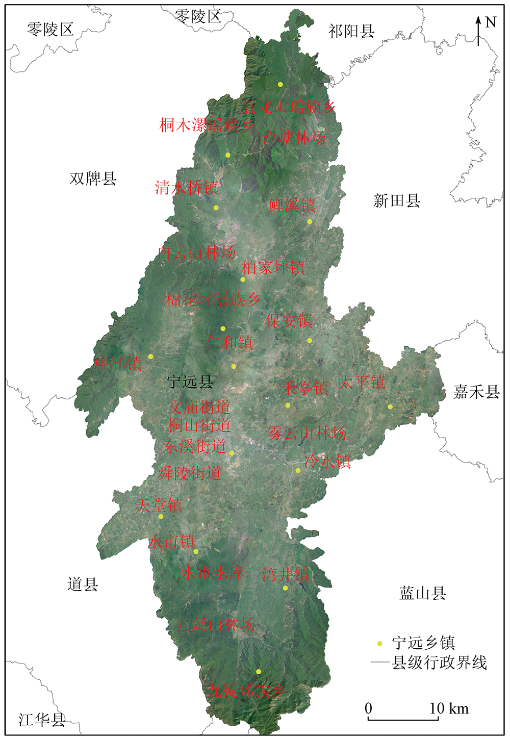
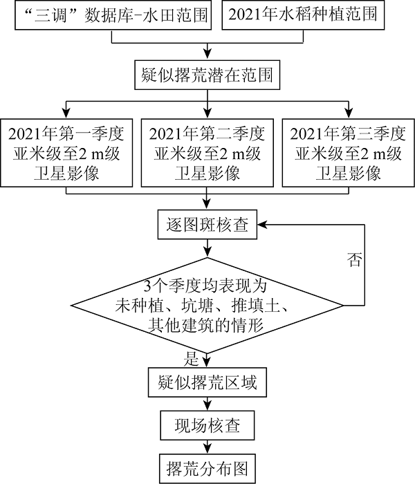
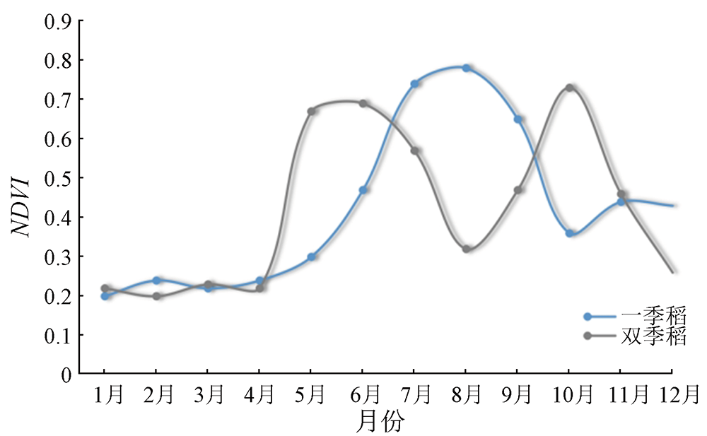
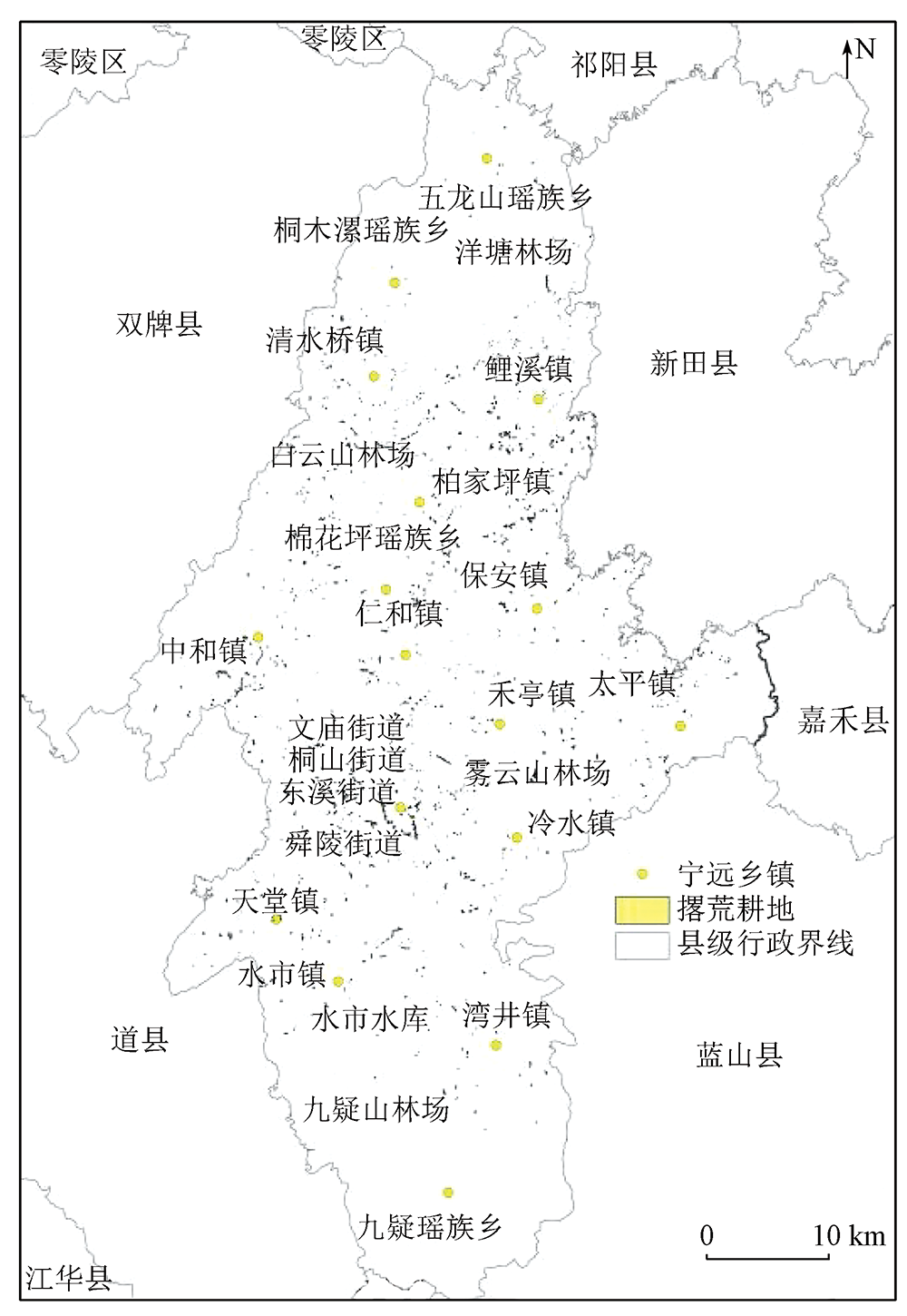
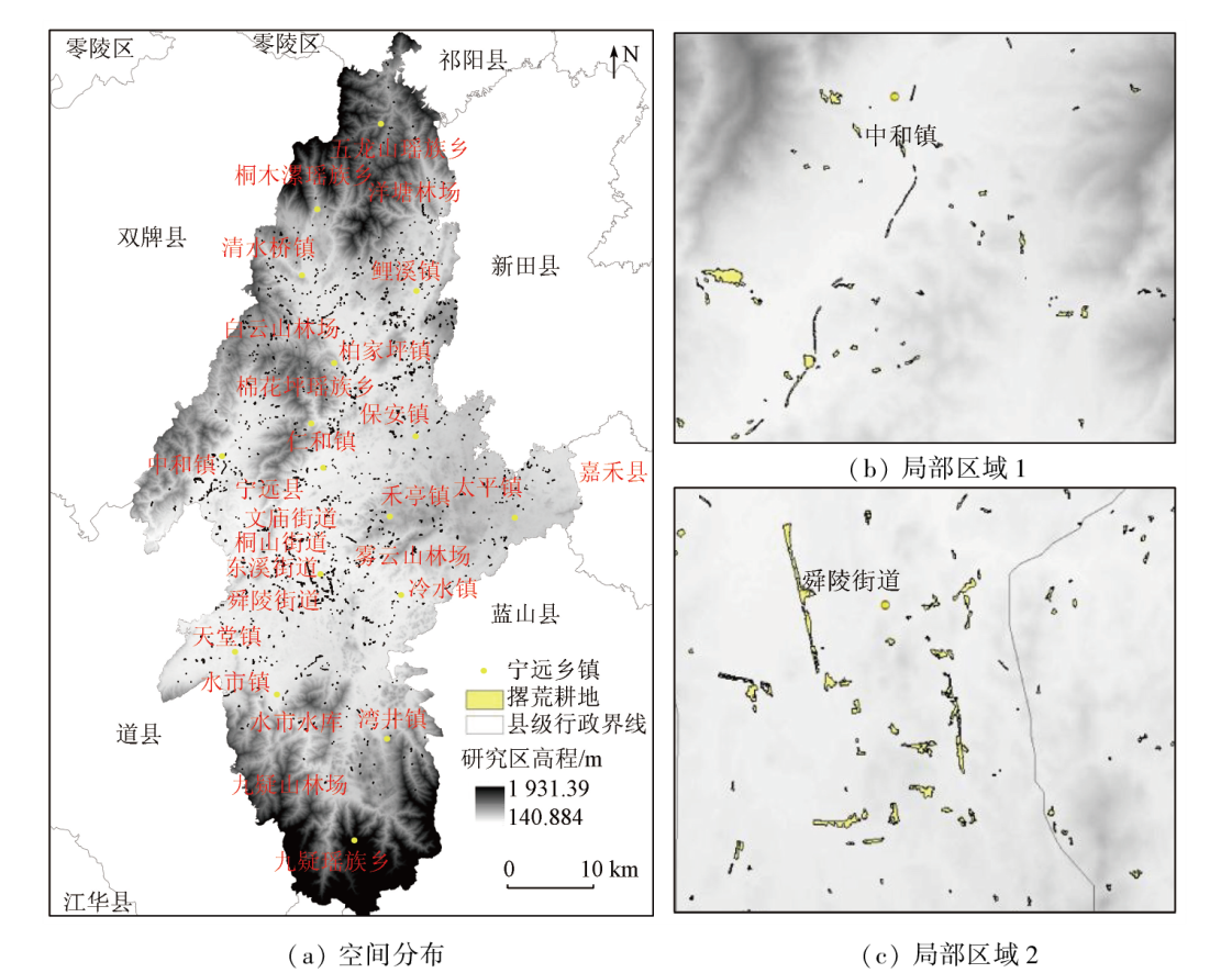
With continuously accelerated urbanization, urban expansion-induced farmland occupation and rural hollowing have gradually aggravated arable land abandonment, posing challenges to China’s food security. Hence, accurately determining the distribution of abandoned arable land is critical to arable land protection and food security. This study investigated a county in the major crop production area in a hilly region in southern China. Based on the phenological characteristics of local rice planting, this study adopted six phases of satellite remote sensing images and aerial images acquired in 2020 and 2021 were used as the data source and selected paddy fields determined based on the Third National Land Survey and field ridges in 1∶2 000 digital line graphics (DLGs) as the minimum information extraction unit. Then, the rice planting patches were extracted through time-series normalized difference vegetation index (NDVI) analysis and the improved SVM method. Suspected abandoned areas were screened out through the difference calculation for two consecutive years and then further identified in the unmanned aerial vehicle (UAV)-based sampling aerial survey. Consequently, the abandoned arable land areas were determined, with monitoring accuracy exceeding 85%, as revealed by on-site verification. The results of this study show that the space-air-ground integrated remote sensing monitoring method can provide scientific and effective data support for agricultural management departments to control and manage cultivated land abandonment.
周小迦. 丘陵地带耕地撂荒遥感监测应用研究[J]. 自然资源遥感, 2024, 36(1): 235-241.
ZHOU Xiaojia. Application of remote sensing monitoring in abandoned arable land in a hilly region. Remote Sensing for Natural Resources, 2024, 36(1): 235-241.
Ma Q X, He S L. To probe into the problems of arable land wasting and its quality declining in rural areas at present[J]. Journal of China Agricultural Resources and Regional Planning, 2002, 23(4):19-21.
[4]
Estel S, Kuemerle T, Alcántara C, et al. Mapping farmland abandonment and recultivation across Europe using MODIS NDVI time series[J]. Remote Sensing of Environment, 2015, 163:312-325.
doi: 10.1016/j.rse.2015.03.028
[5]
Xu Z, Mi W B, Mi N, et al. Characteristics and sources of heavy metal pollution in desert steppe soil related to transportation and industrial activities.[J]. Environmental Science and Pollution Research, 2020, 27(31):38835-38848.
doi: 10.1007/s11356-020-09877-9
[6]
Sayfullina L B, Azizov Z M, Imashev I G, et al. Soil nitrification capacity as an integral indicator of soil fertility monitoring[J]. Russian Agricultural Sciences, 2022, 48(4) :290-295.
doi: 10.3103/S1068367422040127
Zhang H, Gao X H, Shi F F, et al. based on the combination of Sentinel-2 MSI and Sentinel-1 SAR based extraction of abandoned land in the western the Loess Plateau:A case study of Minhe County in Qinghai[J]. Remote Sensing for Natural Resources, 2022, 34(4):144-154.doi:10.6046/gtzyyg.2021385.
Wang L Y, Chen Q, Wu Y, et al. Accurate recognition and extraction of karst abandoned land features based on cultivated land parcels and time series NDVI[J]. Remote Sensing for Land and Resources, 2020, 32 (3):23-31.doi:10.6046/gtzyyg.2020.03.04.
Ding S P, Li M M, Wang X Q, et al. The use of time series remote sensing data to analyze the characteristics of non-agriculture farmland and their driving factors in Fuzhou[J]. Remote Sensing Technology and Application, 2022, 37 (3):550-563.
Mu Y X, Wu M Q, Niu Z, et al. Method of remote sensing extraction of cultivated land area under complex conditions in southern region[J]. Remote Sensing Technology and Application, 2020, 35 (5):1127-1135.
Zhang T Z, Zhang F R, Huang J W, et al. Spatial pattern evolution of abandoned arable land and its influencing factor in industrialized region[J]. Transactions of the Chinese Society of Agricultural Engineering, 2019, 35 (15):246-255.
Teng X B, Ouyang W Y, Lei B. Analysis on causes and countermeasures of farmers occupying cultivated land to build houses:Taking Siyuanshan Village,Baijiaping Town,Ningyuan County as an example[J]. Land and Resources Herald, 2022, 19 (1):72-75.
Cai Q, Zhu H M, Xiao T. On coupling degree of cultivated land quality and productivity:A case study of Ningyuan County,Hunan Province as an example[J]. Shanghai Land and Resources, 2022, 43(2):66-72.
Li S F, Li X B, Xin L J, et al. Extent and distribution of cropland abandonment in Chinese mountainous areas[J]. Resource Science, 2017, 39 (10):1801-1811.
Niu J Q, Lin H, Niu Y N, et al. Analysis of spatial pattern and driving factors for abandoned arable lands in underdevelopment region[J]. Transactions of the Chinese Society for Agricultural Machinery, 2017, 48(2):141-149.
Deng G, Tang Z G, Li C K, et al. Extraction and analysis of spatiotemporal variation of rice planting area in Hunan Province based on MODIS time-series data[J]. Remote Sensing of Land and Resources, 2020, 32 (2):177-185.doi:10.6046/gtzyyg.2020.02.23.
Liu W J, Zeng Y N, Zhang M. Mapping rice paddy distribution by using time series HJ blend data and phenological parameters[J]. Journal of Remote Sensing, 2018, 22 (3):381-391.
Ma S J, Pei Z Y, Wang F, et al. Application on remote sensing survey of abandoned farmlands in winter along the Huaihe River based on GF-1 image[J]. Transactions of the Chinese Society of Agricultural Engineering, 2019, 35(1):227-233.
Xiao G F, Zhu X F, Hou C Y, et al. Extraction and analysis of abandoned farmland:A case study of Qingyun and Wudi Counties in Shandong Province as examples[J]. Acta Geographica Sinica, 2018, 73(9):1658-1673.
Wei Z H, Jin H L, Gu X H, et al. Remote sensing monitoring of cultivated land abandonment based on multi temporal collaborative change detection[J]. Remote Sensing Technology and Application, 2022, 37(3):539-549.
Li Z H, Yan J Z, Hua X B, et al. Factors influencing the culivated land abandonment of households of different types:A case study of 12 typical villages in Chongqing Municipality[J]. Geographical Research, 2014, 33 (4):721-734.
Zheng C G, Qiu D C, Ye G Q, et al. Study on spatial distribution characteristics of abandoned cropland based on spatial analysis of GIS:A case of Dalu Town Bishan County in Chongqing Municipality[J]. Journal of Agricultural Mechanization Research, 2010, 32(3):31-36.
 2024, Vol. 36
  )
)