A hyperspectral unmixing and few-shot classification method based on 3DCAE network
HUANG Chuan1(), LI Yaqin1, QI Yueran2, WEI Xiaoyan3, SHAO Yuanzheng4()
1. School of Mathematics and Computer Science, Wuhan Polytechnic University,Wuhan 430023,China 2. School of Geography and Tourism, Anhui Normal University,Wuhu 241001, China 3. Yunnan Provincial Archives of Surveying and Mapping (Yunnan Provincial Geomatics Centre), Kunming 650034, China 4. Collaborative Innovation Center of Geospatial Technology, Wuhan University, Wuhan 430079, China
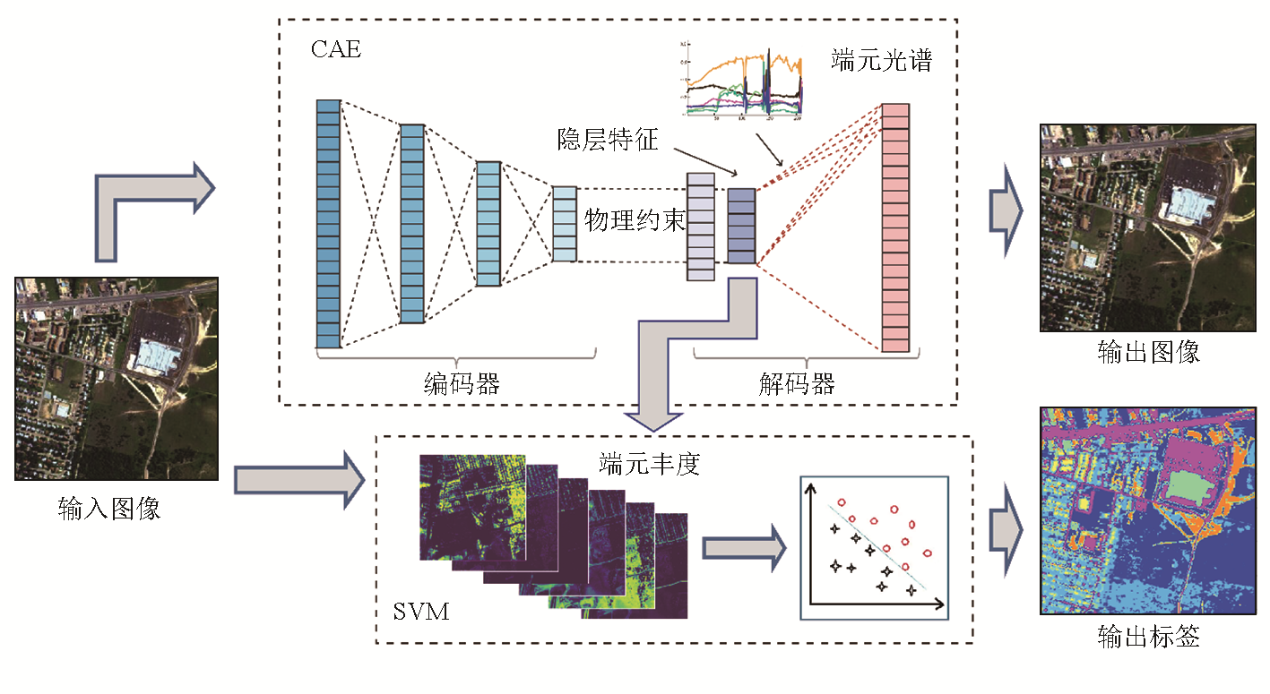
我国高光谱遥感技术的快速发展为开展大区域地物分类应用提供了充分保障。然而,如何在小样本下充分利用高光谱自身的空谱信息实现高精度的分类成为挑战。该文通过构建3D卷积自编码网络,以混合像元分解物理约束对模型进行引导,从而实现在准确估计端元丰度的同时获得对规则化的高光谱空谱特征的有效表达,结合支持向量机分类器实现在小样本条件下的高光谱分类。实验中,采用包括监督分类方法在内的多种传统高光谱图谱特征提取及分类方法进行对比验证,并对比了不同模型在不同采样率下的分类性能表现。实验结果表明,所提出的高光谱分类方法具有明显的精度优势,其中平均交并比(mean intersection over union,mIoU)达到0.829,相对于传统分类方法精度有明显提升; 在1/200采样率下mIoU值依然能接近0.8,优于同类方法,证实了该文方法在小样本条件下依然具有较好的鲁棒性,为解决小样本下高光谱分类问题提供了技术参考。
The rapid development of hyperspectral remote sensing technology in China fully ensures the effective application of large-scale surface feature classification. However, achieving high-precision classification under few-spot conditions while fully leveraging hyperspectral spatial-spectral information remains challenging. This study developed a 3D convolutional autoencoder (3D-CAE) network guided by physical constraints from mixed pixel decomposition. This approach enables accurate estimation of endmember abundance while effectively expressing regularized spatial-spectral features of hyperspectral data. In combination with a support vector machine (SVM) classifier, the method achieves hyperspectral classification under few-spot conditions. The classification performance of various models was evaluated at different sampling rates. To validate the proposed method, this study conducted experiments including comparisons with traditional hyperspectral feature extraction and classification methods, such as supervised classification approaches. The classification performance of various models was also evaluated at different sampling rates. The experimental results demonstrate that the proposed hyperspectral classification method has a significant advantage of accuracy, achieving a mean intersection over union (mIoU) of 0.829, which was close to 0.8 even at a low sampling rate of 1/200, surpassing its counterparts. These results confirm that the proposed method exhibits robustness under few-spot conditions. This study provides a valuable technical reference for addressing hyperspectral classification challenges under few-spot conditions.
Du P J, Tan K, Xia J S, et al. Research on hyperspectral remote sensing image classification and support vector machine application[M]. Beijing: Science Press, 2012,1-160.
[2]
Bioucas-Dias J M, Plaza A, Dobigeon N, et al. Hyperspectral unmixing overview:Geometrical,statistical,and sparse regression-based approaches[J]. IEEE Journal of Selected Topics in Applied Earth Observations and Remote Sensing, 2012, 5(2):354-379.
Liu Y N, Sun D X, Hu X N, et al. Development of visible and short-wave infrared hyperspectral imager onboard GF-5 satellite[J]. Journal of Remote Sensing(Chinese), 2020, 24(4):333-344.
[4]
Zhong Y, Wang X, Wang S, et al. Advances in spaceborne hyperspectral remote sensing in China[J]. Geo-Spatial Information Science, 2021, 24(1):95-120.
[5]
Green A A, Berman M, Switzer P, et al. A transformation for ordering multispectral data in terms of image quality with implications for noise removal[J]. IEEE Transactions on Geoscience and Remote Sensing, 1988, 26(1):65-74.
[6]
Black M, Riley T R, Ferrier G, et al. Automated lithological mapping using airborne hyperspectral thermal infrared data:A case study from Anchorage Island,Antarctica[J]. Remote Sensing of Environment, 2016,176:225-241.
[7]
Alberti A, Alessandro V, Pieruccini U, et al. Landsat TM data processing for lithological discrimination in the Caraculo area (Namibe Province,SW Angola)[J]. Journal of African Earth Sciences (and the Middle East), 1993, 17(3):261-274.
[8]
Hecker C, van der Meijde M, van der Werff H, et al. Assessing the influence of reference spectra on synthetic SAM classification results[J]. IEEE Transactions on Geoscience and Remote Sensing, 2008, 46(12):4162-4172.
[9]
Chang C I. An information-theoretic approach to spectral variability,similarity,and discrimination for hyperspectral image analysis[J]. IEEE Transactions on Information Theory, 2000, 46(5):1927-1932.
[10]
Camps-Valls G, Bruzzone L. Kernel-based methods for hyperspectral image classification[J]. IEEE Transactions on Geoscience and Remote Sensing, 2005, 43(6):1351-1362.
[11]
Zhu X X, Tuia D, Mou L, et al. Deep learning in remote sensing:A comprehensive review and list of resources[J]. IEEE Geoscience and Remote Sensing Magazine, 2017, 5(4):8-36.
[12]
Zhou H, Huang L, Wang Y. Deep learning algorithm and its application in optics[J]. Infrared and Laser Engineering, 2019, 48(12):1226004.
[13]
Han M, Cong R, Li X, et al. Joint spatial-spectral hyperspectral image classification based on convolutional neural network[J]. Pattern Recognition Letters, 2020,130:38-45.
[14]
Li C, Cai R, Yu J. An attention-based 3D convolutional autoencoder for few-shot hyperspectral unmixing and classification[J]. Remote Sensing, 2023, 15(2):451.
[15]
Dobigeon N, Tourneret J Y, Richard C, et al. Nonlinear unmixing of hyperspectral images:Models and algorithms[J]. IEEE Signal Processing Magazine, 2014, 31(1):82-94.
[16]
Winter M E. N-FINDR:An algorithm for fast autonomous spectral end-member determination in hyperspectral data[C]// Imaging Spectrometry V.Denver, CO.SPIE,1999:266-275.
[17]
Zhang X, Sun Y, Zhang J, et al. Hyperspectral unmixing via deep convolutional neural networks[J]. IEEE Geoscience and Remote Sensing Letters, 2018, 15(11):1755-1759.
[18]
Halimi A, Altmann Y, Dobigeon N, et al. Nonlinear unmixing of hyperspectral images using a generalized bilinear model[C]//2011 IEEE Statistical Signal Processing Workshop (SSP). June 28-30,2011, Nice,France.IEEE,2011:413-416.
[19]
Licciardi G A, Del Frate F.Pixel unmixing in hyperspectral data by means of neural networks[J]. IEEE Transactions on Geoscience and Remote Sensing, 2011, 49(11):4163-4172.
[20]
Zhu F, Honeine P. Biobjective nonnegative matrix factorization:Linear versus kernel-based models[J]. IEEE Transactions on Geoscience and Remote Sensing, 2016, 54(7):4012-4022.
[21]
Févotte C, Dobigeon N. Nonlinear hyperspectral unmixing with robust nonnegative matrix factorization[J]. IEEE Transactions on Image Processing, 2015, 24(12):4810-4819.
doi: 10.1109/TIP.2015.2468177
pmid: 26285151
Han Z, Gao L R, Zhang B, et al. Nonlinear hyperspectral unmixing algorithm based on deep autoencoder networks[J]. National Remote Sensing Bulletin, 2020, 24(4):388-400.
Zhu L, Qin K, Li M, et al. Research on improved stacked sparse autoencoders for mineral hyperspectral endmember extraction[J]. Spectroscopy and Spectral Analysis, 2021, 41(4):1288-1293.
Zhu Z Q, Su Y C, Li P F, et al. Spectral-spatial hyperspectral unmixing using deep double-constraints convolutional network[J]. Journal of Signal Processing, 2023, 39(1):128-142.
[25]
Qu Y, Qi H. uDAS:An untied denoising autoencoder with sparsity for spectral unmixing[J]. IEEE Transactions on Geoscience and Remote Sensing, 2019, 57(3):1698-1712.
[26]
Ozkan S, Kaya B, Akar G B. EndNet:Sparse AutoEncoder network for endmember extraction and hyperspectral unmixing[J]. IEEE Transactions on Geoscience and Remote Sensing, 2019, 57(1):482-496.
[27]
Su Y, Li J, Plaza A, et al. DAEN:Deep autoencoder networks for hyperspectral unmixing[J]. IEEE Transactions on Geoscience and Remote Sensing, 2019, 57(7):4309-4321.
[28]
Khajehrayeni F, Ghassemian H. Hyperspectral unmixing using deep convolutional autoencoders in a supervised scenario[J]. IEEE Journal of Selected Topics in Applied Earth Observations and Remote Sensing, 2020,13:567-576.
[29]
Heinz D C, Chang C I. Fully constrained least squares linear spectral mixture analysis method for material quantification in hyperspectral imagery[J]. IEEE Transactions on Geoscience and Remote Sensing, 2001, 39(3):529-545.
[30]
Palsson B, Sveinsson J R, Ulfarsson M O. Blind hyperspectral unmixing using autoencoders:A critical comparison[J]. IEEE Journal of Selected Topics in Applied Earth Observations and Remote Sensing, 2022,15:1340-1372.
[31]
Foody G M. Approaches for the production and evaluation of fuzzy land cover classifications from remotely-sensed data[J]. International Journal of Remote Sensing, 1996, 17(7):1317-1340.
 2025, Vol. 37
  ), 李雅琴1, 祁越然2, 魏晓燕3, 邵远征4(