|
|
|
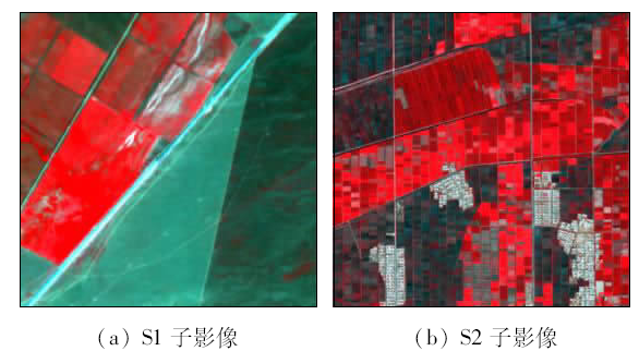
Abstract In view of the problem that the traditional super-pixel Markov random field (MRF) image segmentation model cannot fully utilize spatial context information, a new super-pixel MRF model is proposed. This algorithm incorporates higher-order neighborhood model into the interactive potential term of MRF. The new model enables the interactive potential to fully exploit the spatial context information contained in the super-pixel neighborhood system. Additionally, a new class-wise estimation method for β is proposed, which is based on norm distance. By utilizing two scenes of high-resolution remote sensing images acquired over different agricultural landscapes, validation experiment was conducted. The experiment results indicate that the proposed method can better use the contextual information such as edge strength, thus achieving higher segmentation accuracy. Moreover, the algorithm proposed by the authors showed superior performance when it was compared with other super-pixel MRF approaches.
|
| Keywords
super-pixel
Markov random field (MRF)
higher-order neighborhood
agricultural area
|
|
|
|
Issue Date: 08 February 2018
|
|
|
| [1] |
Löw F,Conrad C,Michel U.Decision fusion and non-parametric classifiers for land use mapping using multi-temporal RapidEye data[J].ISPRS Journal of Photogrammetry and Remote Sensing,2015,108:191-204.
|
| [2] |
Kim H O,Yeom J M.Effect of red-edge and texture features for object-based paddy rice crop classification using RapidEye multi-spectral satellite image data[J].International Journal of Remote Sensing,2014,35(19):7046-7068.
|
| [3] |
杨闫君,占玉林,田庆久,等.基于GF-1/WFV NDVI时间序列数据的作物分类[J].农业工程学报,2015,31(24):155-161.
|
| [3] |
Yang Y J,Zhan Y L,Tian Q J,et al.Crop classification based on GF-1/WFV NDVI time series[J].Transactions of the Chinese Society of Agricultural Engineering,2015,31(24):155-161.
|
| [4] |
Liu M W,Ozdogan M,Zhu X J.Crop type classification by simultaneous use of satellite images of different resolutions[J].IEEE Transactions on Geoscience and Remote Sensing,2014,52(6):3637-3649.
|
| [5] |
Besag J.On the statistical analysis of dirty pictures[J].Journal of the Royal Statistical Society,Series B Methodological,1986,48(3):259-302.
|
| [6] |
Kumar S,Hebert M.Discriminative random fields[J].International Journal of Computer Vision,2006,68(2):179-201.
|
| [7] |
孙巍,郭敏.基于SLIC与条件随机场的图像分割算法[J].计算机应用研究,2015,32(12):3817-3820,3824.
|
| [7] |
Sun W,Guo M.Image segmentation based on SLIC and conditional random field[J].Application Research of Computers,2015,32(12):3817-3820,3824.
|
| [8] |
刘磊,石志国,宿浩茹,等.基于高阶马尔可夫随机场的图像分割[J].计算机研究与发展,2013,50(9):1933-1942.
|
| [8] |
Liu L,Shi Z G,Su H R,et al.Image segmentation based on higher order Markov random field[J].Journal of Computer Research and Development,2013,50(9):1933-1942.
|
| [9] |
Yu Q Y,Clausi D A.IRGS:Image segmentation using edge penalties and region growing[J].IEEE Transactions on Pattern Analysis and Machine Intelligence,2008,30(12):2126-2139.
|
| [10] |
Qin A K,Clausi D A.Multivariate image segmentation using semantic region growing with adaptive edge penalty[J].IEEE Transactions on Image Processing,2010,19(8):2157-2170.
|
| [11] |
苏腾飞,李洪玉.一种结合GBM的MRF遥感图像分割算法[J].内蒙古农业大学学报(自然科学版),2015,36(1):143-149.
|
| [11] |
Su T F,Li H Y.GBM-combined MRF method for remote sensing image segmentation[J].Journal of Inner Mongolia Agricultural University(Natural Science Edition),2015,36(1):143-149.
|
| [12] |
Achanta R,Shaji A,Smith K,et al.SLIC superpixels compared to state-of-the-art superpixel methods[J].IEEE Transactions on Pattern Analysis and Machine Intelligence,2012,34(11):2274-2282.
|
| [13] |
Comaniciu D,Meer P.Mean shift:A robust approach toward feature space analysis[J].IEEE Transactions on Pattern Analysis and Machine Intelligence,2002,24(5):603-619.
|
| [14] |
Levinshtein A,Stere A,Kutulakos K N,et al.TurboPixels:Fast superpixels using geometric flows[J].IEEE Transactions on Pattern Analysis and Machine Intelligence,2009,31(12):2290-2297.
|
| [15] |
Su T F,Li H Y,Zhang S W,et al.Image segmentation using mean shift for extracting croplands from high-resolution remote sensing imagery[J].Remote Sensing Letters,2015,6(12):952-961.
|
|
Viewed |
|
|
|
Full text
|
|
|
|
|
Abstract
|
|
|
|
|
Cited |
|
|
|
|
| |
Shared |
|
|
|
|
| |
Discussed |
|
|
|
|
 2018,
Vol. 30
2018,
Vol. 30
 ), Shengwei ZHANG(