|
|
 |
|

|
|
|
Object recognition of karst farming area based on UAV image: A case study of Guilin |
Peiqing LOU1, Xiaoyu CHEN2, Shutong WANG3, Bolin FU1( ), Yongyi HUANG1, Tingyuan TANG1, Ming LING1 ), Yongyi HUANG1, Tingyuan TANG1, Ming LING1 |
1. Institute of Surveying and Mapping, Guilin University of Technology, Guilin 541006, China
2. Institute of Civil and Architectural Engineering, Guilin University of Technology, Guilin 541006, China
3. Institute of Information Science and Engineering, Guilin University of Technology, Guilin 541006, China |
|
|
|
|
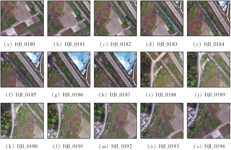
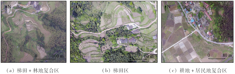
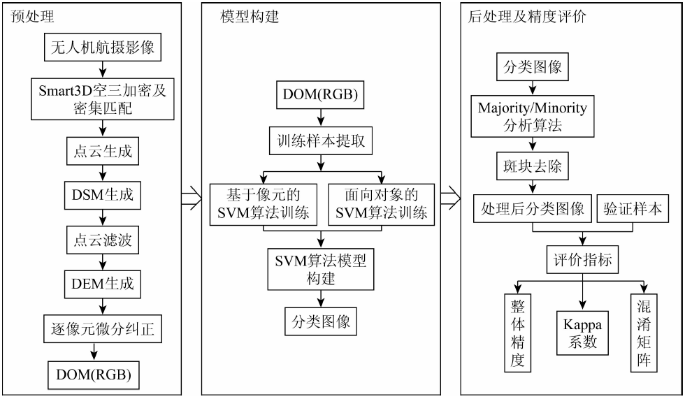
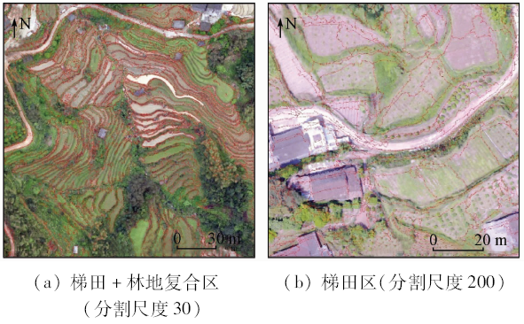
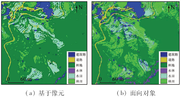
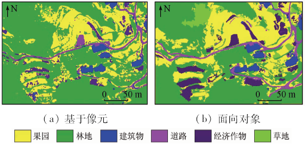
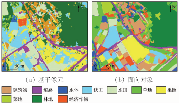
Abstract In order to explore the recognition accuracy of remote sensing technology of low-altitude UAV for surface features in agricultural areas with different forms under karst landform conditions, the authors chose three agricultural areas (each having an area size of 200 m×200 m) in Guilin City as the research object. Supported by UAV aerial images and ground survey data, the image analysis technology based on pixel and object-oriented was combined with support vector machine (SVM) algorithm, respectively, to build the remote sensing recognition model of agricultural areas under different geomorphological conditions, and the precision was comparatively studied and analyzed. The results show that the object-oriented SVM classification results retain the rough outline of the original ground features, and the plot is relatively complete, and hence this means is more suitable for the recognition of ground features in agricultural areas under karst landform conditions. Compared with the pixel based SVM classification method, the overall accuracy is higher by 6.54% , and the Kappa coefficient is higher by 0.135 . The SVM classification method based on pixel is suitable for feature recognition in agricultural areas with regular feature distribution. Compared with the object-oriented SVM classification method, the overall accuracy is higher by 2.92% and the Kappa coefficient is higher by 0.026 .
|
| Keywords
UAV image
agricultural areas
Multi-resolution image segmentation
SVM algorithm
|
|
|
|
Corresponding Authors:
Bolin FU
E-mail: fbl2012@126.com
|
|
Issue Date: 14 March 2020
|
|
|
| [1] |
Ludeno G, Catapano I, Renga A , et al. Assessment of a micro-UAV system for microwave tomography Radar imaging[J]. Remote Sensing of Environment, 2018(212):90-102.
|
| [2] |
袁修孝, 蔡杨, 史俊波 , 等. 北斗辅助无人机航摄影像的空中三角测量[J]. 武汉大学学报(信息科学版), 2017,42(11):1573-1579.
|
| [2] |
Yuan X X, Cai Y, Shi J B , et al. BeiDou-supported aerotriangulation for UAV aerial images[J]. Geomatics and Information Science of Wuhan University, 2017,42(11):1573-1579.
|
| [3] |
郭林凯 . 无人机航摄质量控制与分析[J]. 测绘通报, 2017(s1):203-205,213.
|
| [3] |
Guo L K . Quality control and analysis of UAV aerial photography[J]. Bulletin of Surveying and Mapping, 2017(s1):203-205,213.
|
| [4] |
毕凯, 李英成, 丁晓波 , 等. 轻小型无人机航摄技术现状及发展趋势[J]. 测绘通报, 2015(3):27-31.
|
| [4] |
Bi K, Li Y C, Ding X B , et al. Aerial photogrammetric technology of light small UAV:Status and trend of development[J]. Bulletin of Surveying and Mapping, 2015(3):27-31.
|
| [5] |
Kedzierski M, Wierzbicki D . Radiometric quality assessment of images acquired by UAV’s in various lighting and weather conditions[J]. Measurement, 2015,76(8):156-169.
|
| [6] |
卢秀山, 滕腾, 刘如飞 . 移动测量、地理信息更新与城市管理智能化[J]. 测绘学报, 2017,46(10):1592-1597.
|
| [6] |
Lu X S, Teng T, Liu R F . Mobile mapping,geographic information update and urban management intelligence[J]. Acta Geodaetica et Cartographica Sinica, 2017,46(10):1592-1597.
|
| [7] |
王宇, 陈海涛, 李海川 . 基于引力搜索算法的植保无人机三维路径规划方法[J]. 农业机械学报, 2018,49(2):28-33.
|
| [7] |
Wang Y, Chen H T, Li H C . 3D path planning approach based on gravitational search algorithm for sprayer UAV[J]. Transactions of the Chinese Society for Agricultural Machinery, 2018,49(2):28-33.
|
| [8] |
Gonzalez-Jorge H, Puente I, Roca D , et al. UAV photogrammetry application to the monitoring of rubble mound breakwaters[J]. Journal of Performance of Constructed Facilities, 2016,30(1):1-8.
|
| [9] |
Peppa M V, Mills J P, Moore P , et al. Automated co-registration and calibration in SFM photogrammetry for landslide change detection[J]. Earth Surface Processes and Landforms, 2019,44(1):287-303.
|
| [10] |
Fu B L, Li Y, Wang Y , et al. Evaluation of riparian condition of Songhua River by integration of remote sensing and field measurements[J]. Scientific Reports, 2017, 7(1):2565,1-16.
|
| [11] |
Fu B L, Wang Y, Campbell A , et al. Comparison of object-based and pixel-based random forest algorithm for wetland vegetation mapping using high spatial resolution GF-1 and SAR data[J]. Ecological Indicators, 2017,73(2):105-117.
|
| [12] |
Vapnik V . The Nature of Statistical Learning Theory[M]. Technometrics:Springer, 1995.
|
| [13] |
Cortes C, Vapnik V . Support-vector networks[J]. Machine Learning, 1995,20(3):273-297.
|
| [14] |
Jabari S, Fathollahi F, Roshan A , et al. Improving UAV imaging quality by optical sensor fusion:An initial study[J]. International Journal of Remote Sensing, 2017,38(17):4931-4953.
|
| [15] |
Akar A, Gökalp E, Akar Ö , et al. Improving classification accuracy of spectrally similar land covers in the rangeland and plateau areas with a combination of WorldView-2 and UAV images[J]. Geocarto International, 2017,32(9):990-1003.
|
| [16] |
郝明, 邓喀中, 张华 . 基于遥感数据提取建筑物的主动轮廓改进模型[J]. 中国矿业大学学报, 2012,41(5):833-838.
|
| [16] |
Hao M, Deng K Z, Zhang H . Improved active contour model to extract buildings based on remotely sensed data[J]. Journal of China University of Mining and Technology, 2012,41(5):833-838.
|
| [17] |
Satoru K, Abdallah Z, Farid M , et al. Spatial and structured SVM for multilabel image classification[J]. IEEE Transactions on Geoscience and Remote Sensing, 2018,56(10):5948-5960.
|
| [18] |
Zhao C, Liu W, Xu Y , et al. A spectral-spatial SVM-based multi-layer learning algorithm for hyperspectral image classification[J]. Remote Sensing Letters, 2018,9(3):218-227.
|
| [19] |
Majdar R S, Ghassemian H . A probabilistic SVM approach for hyperspectral image classification using spectral and texture features[J]. International Journal of Remote Sensing, 2017,38(15):4265-4284.
|
| [20] |
Maulik U, Chakraborty D . A self-trained ensemble with semisupervised SVM:An application to pixel classification of remote sensing imagery[J]. Pattern Recognition, 2011,44(3):615-623.
|
| [21] |
Maulik U, Chakraborty D . A novel semisupervised SVM for pixel classification of remote sensing imagery[J]. International Journal of Machine Learning and Cybernetics, 2012,3(3):247-258.
|
| [22] |
Yang H Y, Zhang X J, Wang X Y . LS-SVM-based image segmentation using pixel color-texture descriptors[J]. Pattern Analysis and Applications, 2014,17(2):341-359.
|
| [23] |
Mugiraneza T, Ban Y, Haas J . Urban land cover dynamics and their impact on ecosystem services in Kigali,Rwanda using multi-temporal Landsat data[J]. Remote Sensing Applications:Society and Environment, 2018,13(1):234-246.
|
| [24] |
Li H T, Gu H Y, Han Y S , et al. Object-oriented classification of high-resolution remote sensing imagery based on an improved colour structure code and a support vector machine[J]. International Journal of Remote Sensing, 2010,31(6):1453-1470.
|
| [25] |
Malik R, Kheddam R, Belhadjaissa A . Object-oriented SVM classifier for ALSAT-2A high spatial resolution imagery:A case study of algiers urban area[C]// International Conference on Image Processing Theory.Orleans:IEEE, 2016: 35-40.
|
| [26] |
裴欢, 孙天娇, 王晓妍 . 基于Landsat8 OLI影像纹理特征的面向对象土地利用/覆盖分类[J]. 农业工程学报, 2018,34(2):248-255.
|
| [26] |
Pei H, Sun T J, Wang X Y . Object-oriented land use/cover classification based on texture features of Landsat8 OLI image[J]. Transactions of the Chinese Society of Agricultural Engineering, 2008,34(2):248-255.
|
| [27] |
Benza M, Weeks J R, Stow D A , et al. A pattern-based definition of urban context using remote sensing and GIS[J]. Remote Sensing of Environment, 2016,183:250-264.
|
| [28] |
Park S, Lee H S, Kim J . Seed growing for interactive image segmentation using SVM classification with geodesic distance[J]. Electronics Letters, 2017,53(1):22-24.
|
| [29] |
Mesas-Carrascosa F J, Rumbao I C, Torres-Sánchez J , et al. Accurate ortho-mosaicked six-band multispectral UAV images as affected by mission planning for precision agriculture proposes[J]. International Journal of Remote Sensing, 2017,38(8-10):2161-2176.
|
| [30] |
Diaz-Varela R A, Zarco-Tejada P J, Angileri V , et al. Automatic identification of agricultural terraces through object-oriented analysis of very high resolution DSMs and multispectral imagery obtained from an unmanned aerial vehicle[J]. Journal of Environmental Management, 2014,134(1):117-126.
|
| [31] |
Bazi Y, Melgani F . Convolutional SVM networks for object detection in UAV imagery[J]. IEEE Transactions on Geoscience and Remote Sensing, 2018,56(6):3107-3118.
|
| [32] |
Brovkina O, Cienciala E, Surovy P , et al. Unmanned aerial vehicles (UAV) for assessment of qualitative classification of Norway spruce in temperate forest stands[J]. Geo-Spatial Information Science, 2018,21(1):12-20.
|
| [33] |
Takahashi A, Doria N A D, Bedregal B R C , An introduction interval kernel-based methods applied on support vector machines[C]// Eighth International Conference on Natural Computation.Chongqing:IEEE, 2012.
|
| [34] |
刁淑娟, 刘春玲, 张涛 , 等. 基于SVM的湖泊咸度等级遥感信息提取方法——以内蒙古巴丹吉林沙漠为例[J]. 国土资源遥感, 2016,28(4):114-118.doi: 10.6046/gtzyyg.2016.04.18.
|
| [34] |
Diao S J, Liu C L, Zhang T , et al. Extraction of remote sensing information for lake salinity level based on SVM:A case from Badain Jaran desert in Inner Mongolia[J]. Remote Sensing for Land and Resources, 2016,28(4):114-118.doi: 10.6046/gtzyyg.2016.04.18.
|
|
Viewed |
|
|
|
Full text
|
|
|
|
|
Abstract
|
|
|
|
|
Cited |
|
|
|
|
| |
Shared |
|
|
|
|
| |
Discussed |
|
|
|
|
 2020,
Vol. 32
2020,
Vol. 32