|
|
 |
|

|
|
|
Water vapor retrieval method based on MODIS thermal infrared band and projection pursuit model |
Yitong LIN1, Junfei YE2, Yongqian WANG3( ), Shiquan ZHONG4 ), Shiquan ZHONG4 |
1. Nanning Weather Bureau, Nanning 530022, China
2. Yongning District Weather Bureau,Nanning 530022, China
3. Chengdu University of Information Technology, Chengdu 610225, China
4. Guangxi Institute of Meteorology and Disaster Reduction/Remote Sensing Application and Test Base of National Satellite Meteorology Centre, Nanning 530022, China |
|
|
|
|
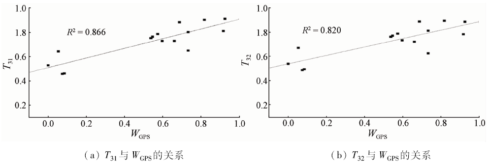
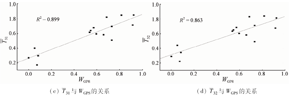
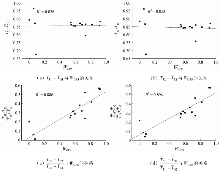
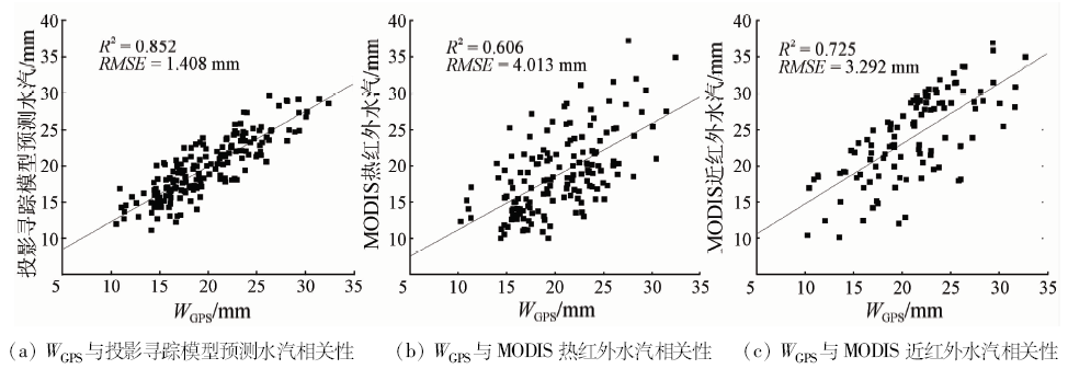
Abstract Precipitable water vapor retrieval methods using MODIS data are mainly based on near infrared and thermal infrared data. Compared with the thermal infrared methods, the near infrared methods have higher inversion accuracy. The near infrared water vapor retrieval method is only applicable to daytime; by contrast, the thermal infrared water vapor data can be obtained both day and night. Therefore, the thermal infrared data are more suitable for operational applications. It is of great significance to improve the accuracy of thermal infrared water vapor retrieval methods. By means of variable selection experiments and results comparing experiments, the precision of variable associations were tested with the optimal substitution variable associations selected, and the water vapour retrieval method based on projection pursuit model has been found. The inversion experiment over the 2015 summer water vapor in the South United States and July 2011 in Shanxi Province of China were carried out through projection pursuit model with inverse results validated by the the water vapor detection data(WGPS). According to the results obtained, in South United States, the root-mean-square error was 2.478 mm based on the water vapor retrieval model of brightness temperature and projection pursuit. In Shanxi province of China, the root-mean-square error was 1.408 mm. Compared with thermal infrared vapor product of MODIS, it had higher accuracy; compared with MODIS near infrared water vapor product, it had higher accuracy and temporal resolution. This method has the potential of business promotion.
|
| Keywords
brightness temperature
water vapor column
projection pursuit
|
|
|
|
Corresponding Authors:
Yongqian WANG
E-mail: wyqq@cuit.edu.cn
|
|
Issue Date: 10 September 2018
|
|
|
| [1] |
李国平, 黄丁发 . GPS遥感区域大气水汽总量研究回顾与展望[J]. 气象科技, 2004,32(4):201-205.
|
| [1] |
Li G P, Huang D F . Reviews and prospects of researches on remote sensing of regional atmospheric water vapor using ground-based GPS[J]. Meteorological Science and Technology, 2004,32(4):201-205.
|
| [2] |
杨景梅, 邱金桓 . 用地面湿度参量计算我国整层大气可降水量及有效水汽含量方法的研究[J]. 大气科学, 2002,26(1):9-22.
doi: 10.3878/j.issn.1006-9895.2002.01.02
|
| [2] |
Yang J M, Qiu J H . A method for estimating precipitable water and effective water vapor content from ground humidity parameters[J]. Chinese Journal of Atmospheric Sciences, 2002,26(1):9-22.
|
| [3] |
徐洪雄, 徐祥德, 陈斌 , 等. 双台风生消过程涡旋能量、水汽输送相互影响的三维物理图像[J]. 气象学报, 2013,71(5):825-838.
doi: 10.11676/qxxb2013.069
url: http://d.wanfangdata.com.cn/Periodical/qxxb201305003
|
| [3] |
Xu H X, Xu X D, Chen B , et al. The structure change and energy moisture transport physical image in the development and decay processes of binary typhoon vortices[J]. Acta Meteorologica Sinica, 2013,71(5):825-838.
|
| [4] |
李大山, 石定朴, 郑新江 , 等. 静止气象卫星水汽图像的分析和应用(一)[J]. 应用气象学报, 1998,9(2):186-196.
doi: 10.1007/s00376-999-0032-1
url: http://www.cnki.com.cn/Article/CJFDTotal-YYQX802.006.htm
|
| [4] |
Li D S, Shi D P, Zheng X J , et al. Analysis and application of GMS 5 water vapor images (I)[J]. Quarterly Journal of Applied Meteorology, 1998,9(2):186-196.
|
| [5] |
郁淑华 . 高原低涡东移过程的水气图像[J]. 高原气象, 2002,21(2):199-204.
|
| [5] |
Yu S H . Water vapor imagery of vortex miving process over Qinghai-Xizang Plateau[J]. Plateau Meteorology, 2002,21(2):199-204.
|
| [6] |
Menzel W P, Seemann S W, Li J , et al. MODIS Atmospheric Profile Retrieval Algorithm Theoretical Basis Document[M].MODIS ATBD version 6, 2002.
|
| [7] |
Seemann S W, Li J, Menzel W P , et al. Operational retrieval of atmospheric temperature, moisture,and ozone from MODIS infrared radiances[J]. Journal of Applied Meteorology, 2003,42(8):1072-1091.
doi: 10.1175/1520-0450(2003)042<1072:OROATM>2.0.CO;2
url: http://journals.ametsoc.org/doi/abs/10.1175/1520-0450%282003%29042%3C1072%3AOROATM%3E2.0.CO%3B2
|
| [8] |
Chang L, Jin S G. MODIS infrared (IR) water vapor calibration model and assessment [C]//Proceedings of the 2013 21st International Conference on Geoinformatics (GEOINFORMATICS).Kaifeng:IEEE, 2013: 1-5.
|
| [9] |
Liu Z Z, Wong M S, Nichol J , et al. A multi-sensor study of water vapour from radiosonde,MODIS and AERONET:A case study of Hong Kong[J]. International Journal of Climatology, 2013,33(1):109-120.
doi: 10.1002/joc.v33.1
url: http://doi.wiley.com/10.1002/joc.v33.1
|
| [10] |
Bennouna Y S, Torres B, Cachorro V E, et al. The annual cycle of total precipitable water vapor derived from different remote sensing techniques:An application to several sites of the Iberian Peninsula [C]//AIP Conference Proceedings 1531.Berlin:AIP, 2013: 296-299.
|
| [11] |
孟宪红, 吕世华, 张堂堂 . MODIS近红外水汽产品的检验、改进及初步应用——以黑河流域金塔绿洲为例[J]. 红外与毫米波学报, 2007,26(2):107-111.
url: http://www.opticsjournal.net/Articles/Abstract?aid=OJ0808170016517C9FbI
|
| [11] |
Meng X H, Lyu S H, Zhang T T . Testing,improvement and application of MODIS near infrared water vapor products-taking Jinta oasis in Heihe River basin as a case study[J]. Journal of Infrared and Millimeter Waves, 2007,26(2):107-111.
|
| [12] |
张正健, 李祚泳, 秦宁生 , 等. 遥感影像投影寻踪回归分类模型[J]. 中国图象图形学报, 2012,17(12):1568-1574.
doi: 10.11834/jig.20121216
url: http://d.wanfangdata.com.cn/Periodical/zgtxtxxb-a201212016
|
| [12] |
Zhang Z J, Li Z Y, Qin N S , et al. Remote sensing image classification model based on projection pursuit regression[J]. Journal of Image and Graphics, 2012,17(12):1568-1574.
|
| [13] |
Ware R H, Fulker D W, Stein S A , et al. SuomiNet:A real-time national GPS network for atmospheric research and education[J]. Bulletin of the American Meteorological Society, 2000,81(4):677-694.
doi: 10.1175/1520-0477(2000)0812.3.CO;2
url: http://journals.ametsoc.org/doi/abs/10.1175/1520-0477%282000%29081%3C0677%3ASARNGN%3E2.3.CO%3B2
|
| [14] |
Schroedter-Homscheidt M, Drews A, Heise S . Total water vapor column retrieval from MSG-SEVIRI split window measurements exploiting the daily cycle of land surface temperatures[J]. Remote Sensing of Environment, 2008,112(1):249-258.
doi: 10.1016/j.rse.2007.05.006
url: http://linkinghub.elsevier.com/retrieve/pii/S0034425707001952
|
| [15] |
Becker F, Li Z L . Temperature-independent spectral indices in thermal infrared bands[J]. Remote Sensing of Environment, 1990,32(1):17-33.
doi: 10.1016/0034-4257(90)90095-4
url: http://linkinghub.elsevier.com/retrieve/pii/0034425790900954
|
| [16] |
Li Z L, Jia L, Su Z B , et al. A new approach for retrieving precipitable water from ATSR2 split-window channel data over land area[J]. International Journal of Remote Sensing, 2003,24(24):5095-5117.
doi: 10.1080/0143116031000096014
url: http://www.tandfonline.com/doi/abs/10.1080/0143116031000096014
|
| [17] |
Bachmann C M, Musman S A, Luong D , et al. Unsupervised BCM projection pursuit algorithms for classification of simulated radar presentations[J]. Neural Networks, 1994,7(4):709-728.
doi: 10.1016/0893-6080(94)90047-7
url: http://linkinghub.elsevier.com/retrieve/pii/0893608094900477
|
| [18] |
肖长来, 危润初, 梁秀娟 , 等. 基于投影寻踪聚类模型的龙坑水源地地下水水质评价[J]. 吉林大学学报(地球科学版), 2011,41(s1):248-252.
|
| [18] |
Xiao C L, Wei R C, Liang X J , et al. Assessment of water quality of groundwater in Longkeng based on projection pursuit cluster model[J]. Journal of Jilin University(Earth Science Edition), 2011,41(s1):248-252.
|
| [19] |
李祚泳, 汪嘉杨, 金相灿 , 等. 基于进化算法的湖泊富营养化投影寻踪回归预测模型[J]. 四川大学学报(工程科学版), 2007,39(2):1-8.
|
| [19] |
Li Z Y, Wang J Y, Jin X C , et al. Evolution algorithm based forecasting model for lake eutrophication using PPR[J]. Journal of Sichuan University(Engineering Science Edition), 2007,39(2):1-8.
|
|
Viewed |
|
|
|
Full text
|
|
|
|
|
Abstract
|
|
|
|
|
Cited |
|
|
|
|
| |
Shared |
|
|
|
|
| |
Discussed |
|
|
|
|
 2018,
Vol. 30
2018,
Vol. 30