|
|
 |
|

|
|
|
Oil-gas information extraction and prospective area prediction based on hydrocarbon microseepage theory: A case study of Salamat Basin in Central Africa |
Chenchao XIAO1,2, Xiaojuan WU3( ), Daming WANG4, Yongbin CHU3 ), Daming WANG4, Yongbin CHU3 |
1. Land Satellite Remote Sensing Application Center, Ministry of Natural Resources, Beijing 100048, China
2. China Aero Geophysical Survey and Remote Sensing Center for Natural Resources, Beijing 100083,China
3. College of Resources and Environment, Chengdu University of Information Technology,Chengdu 610225, China
4. China Geological Survey, Beijing 100037, China |
|
|
|
|
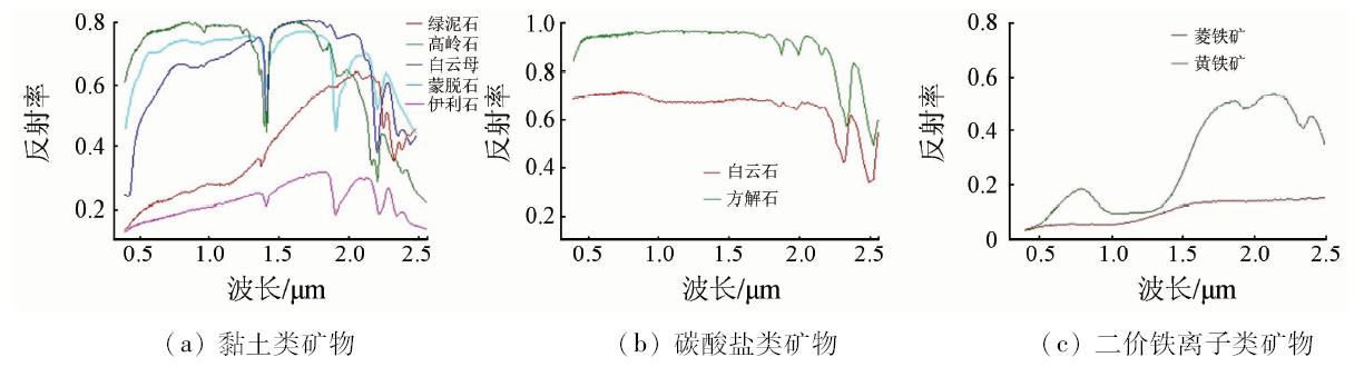
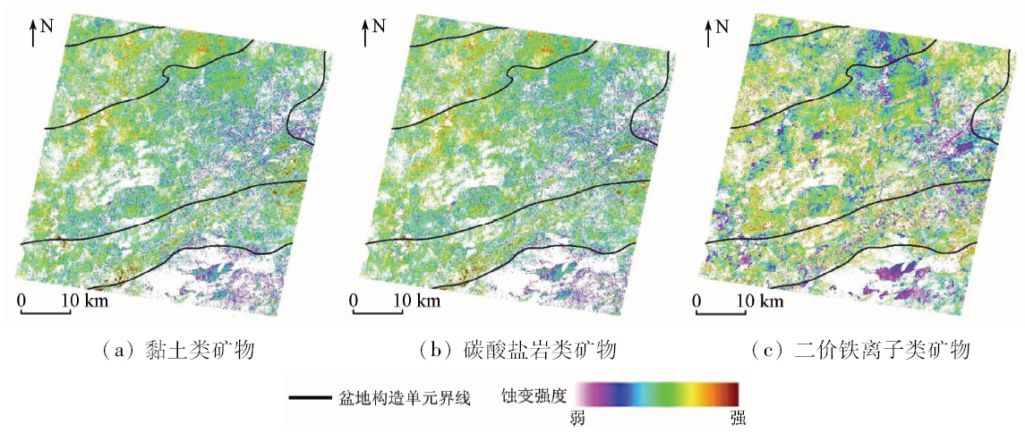
Abstract Anomaly information caused by hydrocarbon seepage in oil-gas fields can be detected by remote sensing technology. Compared with traditional oil and gas exploration methods,remote sensing technology has many advantages in getting information from long range, large-area mapping, high efficiency and low cost, especially in areas with complex terrain and geomorphological environment. Based on the hydrocarbon microseepage theory, the mineral alteration information such as clays, carbonates, ferrous ion and brightness temperature were respectively extracted by methods of crosstalk correction, atmospheric correction, band ratio, principal component analysis and mono-window algorithm with the ASTER data in Salamat Basin of Central Africa. The results show that the above-mentioned several types of strong mineral alteration information and high temperature anomaly information are mainly distributed in the central and southern part of the study area, namely, the central uplift zone and the southern depression zone are highly likely to contain hydrocarbons. Combined with existing geological, seismic, geophysical and geochemical data, five oil-gas prospecting areas were delineated, which can provide theoretical direction for the further oil-gas exploration.
|
| Keywords
hydrocarbon microseepage
mineral alteration information
brightness temperature
oil-gas target prediction
ASTER data
Salamat Basin
|
|
|
|
Corresponding Authors:
Xiaojuan WU
E-mail: wuxiaojuan@cuit.edu.cn
|
|
Issue Date: 03 December 2019
|
|
|
| [1] |
赵健, 童晓光, 肖坤叶 , 等. 乍得Bongor盆地储层沉积成岩特征及其主控因素[J]. 吉林大学学报(地球科学版), 2013,43(3):649-658.
|
| [1] |
Zhao J, Tong X G, Xiao K Y , et al. Sedimentary-diagenetic characteristics of reservoir sandstone and their controlling factors in Bongor Basin,Chad[J]. Journal of Jilin University (Earth Science Edition), 2013,43(3):649-658.
|
| [2] |
程顶胜, 窦立荣, 王景春 , 等. 乍得Bongor盆地天然气地球化学特征及成因[J]. 地学前缘, 2018,25(2):112-120.
|
| [2] |
Cheng D S, Dou L R, Wang J C , et al. Geochemical characteristics and genesis of natural gas in the Bongor Basin[J]. Earth Science Frontiers, 2018,25(2):112-120.
|
| [3] |
肖坤叶, 赵健, 余朝华 , 等. 中非裂谷系Bongor盆地强反转裂谷构造特征及其对油气成藏的影响[J]. 地学前缘, 2014,21(3):172-180.
|
| [3] |
Xiao K Y, Zhao J, Yu C H , et al. Structural characteristics of intensively inversed Bongor Basin in CARS and their impacts on hydrocarbon accumulation[J]. Earth Science Frontiers, 2014,21(3):172-180.
|
| [4] |
张艺琼, 何登发, 童晓光 . 中非剪切带含油气盆地成因机制与构造类型[J]. 石油学报, 2015,36(10):1234-1247.
|
| [4] |
Zhang Y Q, He D F, Tong X G . Genetic mechanisms and tectonic types of petroliferous basins in the Central Africa Shear Zone[J]. Acta Petrolei Sinica, 2015,36(10):1234-1247.
|
| [5] |
窦立荣, 王景春, 王仁冲 , 等. 中非裂谷系前寒武系基岩油气成藏组合[J]. 地学前缘, 2018,25(2):15-23.
|
| [5] |
Dou L R, Wang J C, Wang R C , et al. The Precambrian basement play in the Central African Rift System[J]. Earth Science Frontiers, 2018,25(2):15-23.
|
| [6] |
Yang H, Zhang J, van der Meer F ,et al.Geochemistry and field spectrometry for detecting hydrocarbon miscro-seepage[J]. Terra Nova, 1998,10(5):231-235.
|
| [7] |
Tedesco S A . Surface Geochemistry in Petroleum Exploration[M]. New York:Chapman and Hall, 1995.
|
| [8] |
Schumacher D . Hydrocarbon-induced alteration of soils and sediments[M] //Schumacher D,Abrams M A.Hydrocarbon migration and its near-surface expression.Oklahoma:AAPG Memoir, 1996,66:71-89.
|
| [9] |
王福印 . 油气微渗漏遥感影像异常形成的化学机理[J]. 国土资源遥感, 1993,5(1):59-62.doi: 10.6046/gtzyyg.1993.01.11.
doi: 10.6046/gtzyyg.1993.01.11
|
| [9] |
Wang F Y . Chemical mechanism of image anomalies formed by oil and gas micro-seepage[J]. Remote Sensing for Land and Resources, 1993,5(1):59-62.doi: 10.6046/gtzyyg.1993.01.11.
|
| [10] |
申晋利, 丁树柏, 齐小平 , 等. 烃类微渗漏现象遥感检测研究进展[J]. 国土资源遥感, 2010,22(3):7-11.doi: 10.6046/gtzyyg.2010.03.02.
doi: 10.6046/gtzyyg.2010.03.02
|
| [10] |
Shen J L, Ding S B, Qi X P , et al. The progress of remote sensing technology in the detection of hydrocarbon micro-seepage[J]. Remote Sensing for Land and Resources, 2010,22(3):7-11.doi: 10.6046/gtzyyg.2010.03.02.
|
| [11] |
黄秀华, 李正文, 关燕宁 , 等. 热红外遥感找油的时效性研究[J]. 遥感学报, 2003,7(2):142-145.
doi: 10.11834/jrs.20030211
|
| [11] |
Huang X H, Li Z W, Guan Y N , et al. Temporal effectiveness of thermal infra-red remote sensing applied to oil-gas exploration[J]. Journal of Remote Sensing, 2003,7(2):142-145.
|
| [12] |
汤玉平, 王国建, 程同金 . 烃类垂向微渗漏理论研究现状及发展趋势[J]. 物探与化探, 2008,32(5):465-469.
|
| [12] |
Tang Y P, Wang G J, Cheng T J . Present research situation and development trend of hydrocarbon vertical micro-seepage theory[J]. Geophysical and Geochemical Exploration, 2008,32(5):465-469.
|
| [13] |
李倩倩, 陈小梅, 刘幸 , 等. 油气微渗漏区蚀变矿物含量与光谱之间的定量分析[J]. 光谱学与光谱分析, 2013,33(12):3318-3320.
url: http://www.opticsjournal.net/Articles/Abstract?aid=OJ140109000080PlSoVr
|
| [13] |
Li Q Q, Chen X M, Liu X , et al. Quantitative analysis of content and spectrum of altered mineral in the oil and gas microseepage area[J]. Spectroscopy and Spectral Analysis, 2013,33(12):3318-3320.
|
| [14] |
周子勇 . 高光谱遥感油气勘探进展[J]. 遥感技术与应用, 2014,29(2):352-361.
doi: 10.11873j.issn.1004-0323.2014.2.0352
|
| [14] |
Zhou Z Y . Progress in hyperspectral remote sensing for petroleum prospecting[J]. Remote Sensing Technology and Application, 2014,29(2):352-361.
|
| [15] |
胡畔, 田庆久, 闫柏琨 . 柴达木盆地烃蚀变矿物高光谱遥感识别研究[J]. 国土资源遥感, 2009,21(2):54-61.doi: 10.6046/gtzyyg.2009.02.12.
doi: 10.6046/gtzyyg.2009.02.12
|
| [15] |
Hu P, Tian Q J, Yan B K . The application of hyperspectral remote sensing to the identification of hydrocarbon alteration minerals in Qaidam Basin[J]. Remote Sensing for Land and Resources, 2009,21(2):54-61.doi: 10.6046/gtzyyg.2009.02.12.
|
| [16] |
杨达昌, 陈洁, 高子弘 , 等. 天宫一号高光谱数据烃类微渗漏信息提取[J]. 国土资源遥感, 2018,30(2):107-113.doi: 10.6046/gtzyyg.2018.02.15.
|
| [16] |
Yang D C, Chen J, Gao Z H , et al. Extraction of hydrocarbon micro-seepage information based on TG-1 hyperspectral data[J]. Remote Sensing for Land and Resources, 2018,30(2):107-113.doi: 10.6046/gtzyyg.2018.02.15.
|
| [17] |
章桂芳, 王远华, 郑卓 . 基于ASTER数据的烃蚀变信息增强与提取[J]. 中山大学学报(自然科学版), 2014,53(6):78-84.
|
| [17] |
Zhang G F, Wang Y H, Zheng Z . The information enhancement and interpretation of hydrocarbon microseepage induced minerals based on ASTER data[J]. Acta Scientiarum Naturalium Universitatis Sunyatseni, 2014,53(6):78-84.
|
| [18] |
朱振海 . 油气藏烃类微渗漏理论及遥感油气资源探测的机理研究[J]. 遥感技术与应用, 1994,9(1):1-10.
|
| [18] |
Zhu Z H . Hydrocarbon microseepage theory and oil-gas reservoir detecting by remote sensing[J]. Remote Sensing Technology and Application, 1994,9(1):1-10.
|
| [19] |
Buckingham W F, Sommer S E . Mineralogical characterization of rock surfaces formed by hydrothermal alteration and weathering-application to remote sensing[J]. Economic Geology, 1983,78(4):664-674.
|
| [20] |
Abdelsalam M G, Stern R J, Berhane W G . Mapping gossans in arid regions with Landsat TM and SIR-C images:The Beddaho alteration zone in northern Eritrea[J]. Journal of African Earth Sciences, 2000,30(4):903-916.
|
| [21] |
Yang H, Zhang J, van der Meer F ,et al.Spectral characteristics of wheat associated with hydrocarbon microseepage[J]. International Journal of Remote Sensing, 1999,20(4):807-813.
|
| [22] |
Salati S, van Ruitenbeek F, van der Meer F , et al. Detection of alteration induced by onshore gas seeps from ASTER and WorldView-2 data[J]. Remote Sensing, 2014,6(4):3188-3209.
|
| [23] |
Crosta A, Moore J . Geological mapping using Landsat Thematic Mapper imagery in Almeria Province,south-east Spain[J]. International Journal of Remote Sensing, 1989,10(3):505-514.
|
| [24] |
Carroll H B, Guo G . A New Methodology for Oil and Gas Exploration Using Remote Sensing Data and Surface Fracture Analysis[R]. United States:National Petroleum Technology Office, 1999.
|
| [25] |
汪子义, 张廷斌, 易桂花 , 等. Landsat8 OLI数据斑岩铜矿遥感蚀变矿物组合提取研究[J]. 国土资源遥感, 2018,30(3):89-95.doi: 10.6046/gtzyyg.2018.03.13.
|
| [25] |
Wang Z Y, Zhang T B, Yi G H , et al. Extraction of hydrothermal alteration mineral groups of porphyry copper deposits using Landsat8 OLI data[J]. Remote Sensing for Land and Resources, 2018,30(3):89-95.doi: 10.6046/gtzyyg.2018.03.13.
|
| [26] |
成功, 朱佳玮, 毛先成 . 基于ASTER数据的金川铜镍矿床外围遥感找矿预测[J]. 国土资源遥感, 2016,28(1):15-21.doi: 10.6046/gtzyyg.2016.01.03.
doi: 10.6046/gtzyyg.2016.01.03
|
| [26] |
Cheng G, Zhu J W, Mao X C . Remote sensing prospecting prediction in periphery of the Jinchuan copper-nickel deposit based on ASTER data[J]. Remote Sensing for Land and Resources, 2016,28(1):15-21.doi: 10.6046/gtzyyg.2016.01.03.
|
| [27] |
吴小娟, 温静, 肖晨超 , 等. 基于多源遥感数据的矿物蚀变信息提取——以西藏甲玛铜多金属矿为例[J]. 地质力学学报, 2015,21(2):228-240.
|
| [27] |
Wu X J, Wen J, Xiao C C , et al. Extraction of altered mineral information based on multi-source remote sensing data:A case study of Jiama copper polymetallic deposit[J]. Journal of Geomechanics, 2015,21(2):228-240.
|
| [28] |
任广利, 杨敏, 李健强 , 等. 高光谱蚀变信息在金矿找矿预测中的应用研究——以北山方山口金矿线索为例[J]. 国土资源遥感, 2017,29(3):182-190.doi: 10.6046/gtzyyg.2017.03.27.
|
| [28] |
Ren G L, Yang M, Li J Q , et al. Application of hyper-spectral alteration information to gold prospecting:A case study of Fangshankou area,Beishan[J]. Remote Sensing for Land and Resources, 2017,29(3):182-190.doi: 10.6046/gtzyyg.2017.03.27.
|
| [29] |
刘志武, 党安荣, 雷志栋 , 等. 利用ASTER遥感数据反演陆面温度的算法及应用研究[J]. 地理科学进展, 2003,22(5):507-514.
doi: 10.11820/dlkxjz.2003.05.009
|
| [29] |
Liu Z W, Dang A R, Lei Z D , et al. A retrieval model of land surface temperature with ASTER data and its application study[J]. Progress in Geography, 2003,22(5):507-514.
|
| [30] |
Iwasaki A, Fujisada H, Akao H , et al. Enhancement of spectral separation performance for ASTER/SWIR [C]//The International Society for Optical Engineering.San Diego:SPIE, 2002: 42-50.
|
| [31] |
余健, 张志, 李闵佳 , 等. 基于ASTER遥感影像的西昆仑岩性信息提取方法研究[J]. 国土资源遥感, 2012,24(1):22-27.doi: 10.6046/gtzyyg.2012.01.05.
doi: 10.6046/gtzyyg.2012.01.05
|
| [31] |
Yu J, Zhang Z, Li M J , et al. The methodology of lithologic information extraction by using ASTER data in West Kunlun Mountains[J]. Remote Sensing for Land and Resources, 2012,24(1):22-27.doi: 10.6046/gtzyyg.2012.01.05.
|
| [32] |
罗慧芬, 苗放, 叶成名 , 等. 基于FLAASH模型的ASTER卫星影像大气校正[J]. 安徽农业科学, 2009,37(17):8101-8102.
|
| [32] |
Luo H F, Miao F, Ye C M , et al. Atmospheric correction on ASTER satellite image based on FLAASH model[J]. Journal of Anhui Agricultural Sciences, 2009,37(17):8101-8102.
|
| [33] |
亓雪勇, 田庆久 . 光学遥感大气校正研究进展[J]. 国土资源遥感, 2005,17(4):1-6.doi: 10.6046/gtzyyg.2005.04.01.
doi: 10.6046/gtzyyg.2005.04.01
|
| [33] |
Qi X Y, Tian Q J . The advances in the study of atmospheric correction for optical remote sensing[J]. Remote Sensing for Land and Resources, 2005,17(4):1-6.doi: 10.6046/gtzyyg.2005.04.01.
|
| [34] |
孟翔晨, 历华, 杜永明 , 等. 基于ASTER GED产品的地表发射率估算[J]. 遥感学报, 2016,20(3):382-396.
|
| [34] |
Meng X C, Li H, Du Y M , et al. Estimating land surface emissivity from ASTER GED products[J]. Journal of Remote Sensing, 2016,20(3):382-396.
|
| [35] |
张春森, 徐肖雷, 陈越峰 . 基于ETM+数据的煤田火区温度异常信息提取[J]. 国土资源遥感, 2017,29(2):201-206.doi: 10.6046/gtzyyg.2017.02.29.
|
| [35] |
Zhang C S, Xu X L, Chen Y F . Temperature anomaly information extraction in coalfield fire area based on ETM+ data[J]. Remote Sensing for Land and Resources, 2017,29(2):201-206.doi: 10.6046/gtzyyg.2017.02.29.
|
| [36] |
Song L S, Liu S M, Kustas W P , et al. Using the surface temperature-albedo space to separate regional soil and vegetation temperatures from ASTER data[J]. Remote Sensing, 2015,7(5):5828-5848.
|
|
Viewed |
|
|
|
Full text
|
|
|
|
|
Abstract
|
|
|
|
|
Cited |
|
|
|
|
| |
Shared |
|
|
|
|
| |
Discussed |
|
|
|
|
 2019,
Vol. 31
2019,
Vol. 31