|
|
 |
|

|
|
|
Thermal discharge monitoring of nuclear power plant with aerial remote sensing technology using a UAV platform: Take Hongyanhe Nuclear Power Plant,Liaoning Province,as example |
Xiang WANG1, Xinxin WANG1, Xiu SU1( ), Qinghui MENG1, Dejun ZOU2, Xiaodong YI3, Lin WANG1, Shiyong WEN1, Jianhua ZHAO1 ), Qinghui MENG1, Dejun ZOU2, Xiaodong YI3, Lin WANG1, Shiyong WEN1, Jianhua ZHAO1 |
1. Key Laboratory for Ecological Environment in Coastal Areas (SOA), National Marine Environmental Monitoring Center , Dalian 116023, China
2. Dalian Aerospace Beidou Technology Co., Ltd., Dalian 116023, China
3. Research Institute of Surveying and Spatial Information Technology, School of Civil and Engineering, Dalian University of Technology, Dalian 116023, China |
|
|
|
|
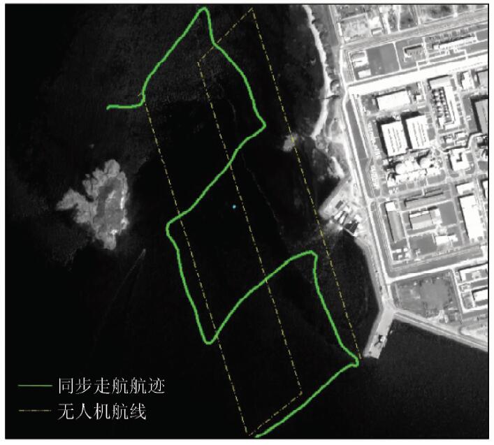
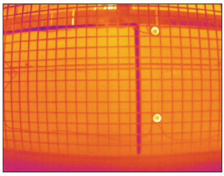
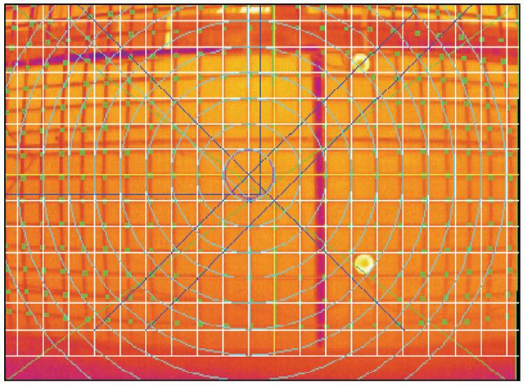
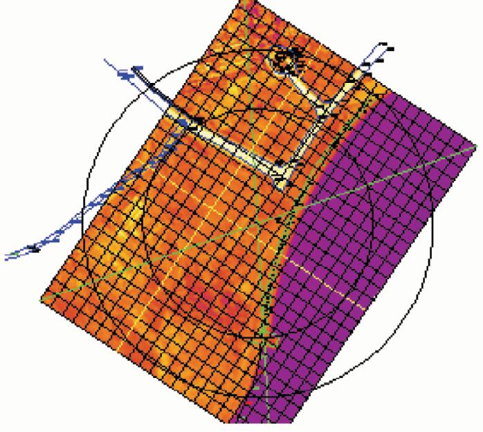
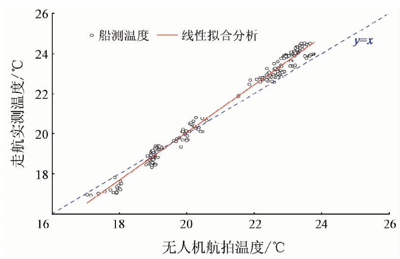
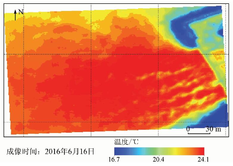
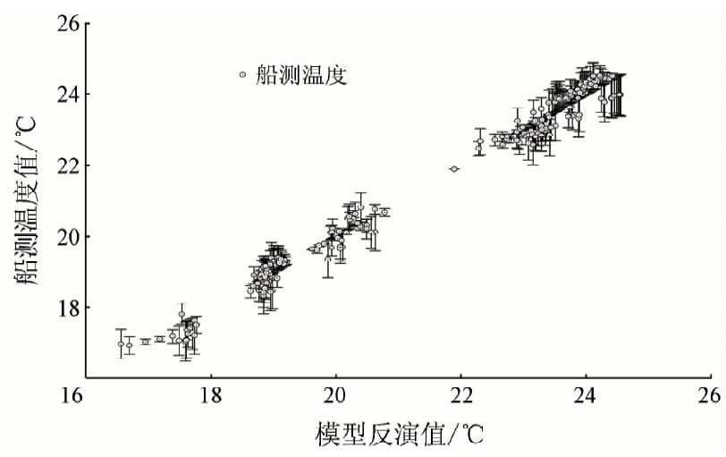
Abstract Existing monitoring approaches are not effective in dealing with routine thermal discharge monitoring requirements of nuclear power plants. This paper describes a monitoring methodology using an aerial remote sensing monitoring system based on an unmanned aerial vehicle (UAV) platform by taking the monitoring of the thermal discharge of the Hongyanhe Nuclear Power Plant, Liaoning Province as an example, and conducts a study of remote sensing extraction of thermal diffusion information of the thermal discharge. In this study, quartic polynomial fitting and real data correction are used to correct the wide-angle distortion and acquire the water body surface temperature information, respectively. Synchronized measured data validation of independent samples indicates that the system can acquire diffusion information of the thermal discharge accurately, and the retrieval error of the surface water temperature is within 0.4 °C. Results analysis shows that this efficient and convenient aerial remote sensing monitoring system based on a UAV platform can effectively make up inadequacies of existing monitoring technical measures and offers high precision. This system is expected to be further adopted and applied for post-assessment of the environmental impact of nuclear power plant thermal discharge and service monitoring.
|
| Keywords
unmanned aerial vehicle (UAV) platform
aerial remote sensing
thermal discharge
wide-angle imaging distortion
|
|
|
|
Corresponding Authors:
Xiu SU
E-mail: xsu@nmemc.org.cn
|
|
Issue Date: 07 December 2018
|
|
|
| [1] |
朱利, 赵利民, 王桥 , 等. 核电站温排水分布卫星遥感监测及验证[J]. 光谱学与光谱分析, 2014,34(11):3079-3084.
url: http://www.opticsjournal.net/Articles/Abstract?aid=OJ141208000641NkQmTp
|
| [1] |
Zhu L, Zhao L M, Wang Q , et al. Monitoring the thermal plume from nuclear power plant using satellite remote sensing data:Modeling and validation[J]. Spectroscopy and Spectral Analysis, 2014,34(11):3079-3084.
|
| [2] |
许静, 朱利, 姜建 , 等. 基于HJ-1B与TM热红外数据的大亚湾核电基地温排水遥感监测[J]. 中国环境科学, 2014,34(5):1181-1186.
doi: 10.3969/j.issn.1000-6923.2014.05.019
url: http://d.wanfangdata.com.cn/Periodical_zghjkx201405019.aspx
|
| [2] |
Xu J, Zhu L, Jiang J , et al. Monitoring thermal discharge in Daya Bay plant based on thermal infrared band of HJ-1B and TM remote sensing data[J]. China Environmental Science, 2014,34(5):1181-1186.
|
| [3] |
周颖, 巩彩兰, 匡定波 , 等. 基于环境减灾卫星热红外波段数据研究核电厂温排水分布[J]. 红外与毫米波学报, 2012,31(6):544-549.
url: http://www.opticsjournal.net/Articles/Abstract?aid=OJ121224000159C0FbIe
|
| [3] |
Zhou Y, Gong C L, Kuang D B , et al. Distribution of thermal discharge from a power plant:Analysis of thermal infrared data from the environmental mitigation satellite[J]. Journal of infrared and millimeter waves, 2012,31(6):544-549.
|
| [4] |
许静 . 基于HJ-1B红外相机监测宁德核电温排水研究[D].北京:中国地质大学(北京), 2014.
|
| [4] |
Xu J . The Study on Monitoring Thermal Discharge of Ningde Nuclear Power Plant with HJ-1B Infarred Camera Data[D].Beijing:Beijing University of Geoscience(Beijing), 2014.
|
| [5] |
王祥, 苏岫, 王新新 , 等. 基于Landsat-8卫星数据的红沿河核电站温排水监测[J]. 红外, 2015,36(8):22-27.
url: http://www.opticsjournal.net/Articles/Abstract?aid=OJ150908000419cJfLiO
|
| [5] |
Wang X, Su X, Wang X X , et al. Thermal plume monitoring of Hongyanhe nuclear power plant based on Landsat-8 satellite data[J]. Infrared, 2015,36(8):22-27.
|
| [6] |
张永红, 陈翰阅, 陈宜金 , 等. 基于Landsat-8/TIRS的红沿河核电基地海表温度反演算法比对[J]. 航天返回与遥感, 2015,36(5):96-104.
doi: 10.3969/j.issn.1009-8518.2015.05.012
url: http://d.wanfangdata.com.cn/Periodical/htfhyyg201505016
|
| [6] |
Zhang Y H, Chen H Y, Chen Y J , et al. Comparative study on sea surface temperature retrieval methods of Hongyanhe nuclear power plant based on Landsat-8/TIRS[J]. Spacecraft recovery and remote sensing, 2015,36(5):96-104.
|
| [7] |
贺佳惠, 梁春利, 李明松 . 核电站近岸温度场航空热红外遥感测量数据处理研究[J]. 国土资源遥感, 2010,22(3):51-53.doi: 10.6046/gtzyyg.2010.03.11.
|
| [7] |
He J H, Liang C L, Li M S . Temperature field airborne thermal remote sensing survey of the alongshore nuclear power station[J]. Remote sensing for land and resources, 2010,22(3):51-53.doi: 10.6046/gtzyyg.2010.03.11.
|
| [8] |
孙恋君, 王凤英, 朱晓翔 . 田湾核电站温排水环境影响遥感调查[J]. 中国辐射卫生, 2011,20(3):330-332.
url: http://d.wanfangdata.com.cn/Periodical/zgfsws201103044
|
| [8] |
Sun L J, Wang F Y, Zhu X X . Remote sensing survey on environmental effects of thermal plume caused by Tianwan nuclear power station[J]. Chinese Journal of Radiological Health, 2011,20(3):330-332.
|
| [9] |
Donlon C J, Minnett P J, Gentemann C , et al. Toward improved validation of satellite sea surface skin temperature measurements for climate research[J]. Journal of Climate, 2002,15(4):353-369.
doi: 10.1175/1520-0442(2002)015<0353:TIVOSS>2.0.CO;2
url: http://journals.ametsoc.org/doi/abs/10.1175/1520-0442%282002%29015%3C0353%3ATIVOSS%3E2.0.CO%3B2
|
| [10] |
Katsaros K B . The aqueous thermal boundary layer[J]. Boundary-Layer Meteorology, 1980,18(1):107-127.
doi: 10.1007/BF00117914
url: http://link.springer.com/10.1007/BF00117914
|
|
Viewed |
|
|
|
Full text
|
|
|
|
|
Abstract
|
|
|
|
|
Cited |
|
|
|
|
| |
Shared |
|
|
|
|
| |
Discussed |
|
|
|
|
 2018,
Vol. 30
2018,
Vol. 30