|
|
 |
|

|
|
|
Information extraction of the Ebinur Lake artemia based on object - oriented method |
Wei LI1,2, Weinan LIU1, Yueping JIA1, Hongyang LIU1, Yong TANG1,2( ) ) |
1. Institute of Marine Science and Technology and the Environment, Dalian Ocean University, Dalian 116023, China
2. The Nearshore Environmental Science and Technology Key Laboratory of Liaoning Province Colleges and Universities, Dalian 116023, China |
|
|
|
|
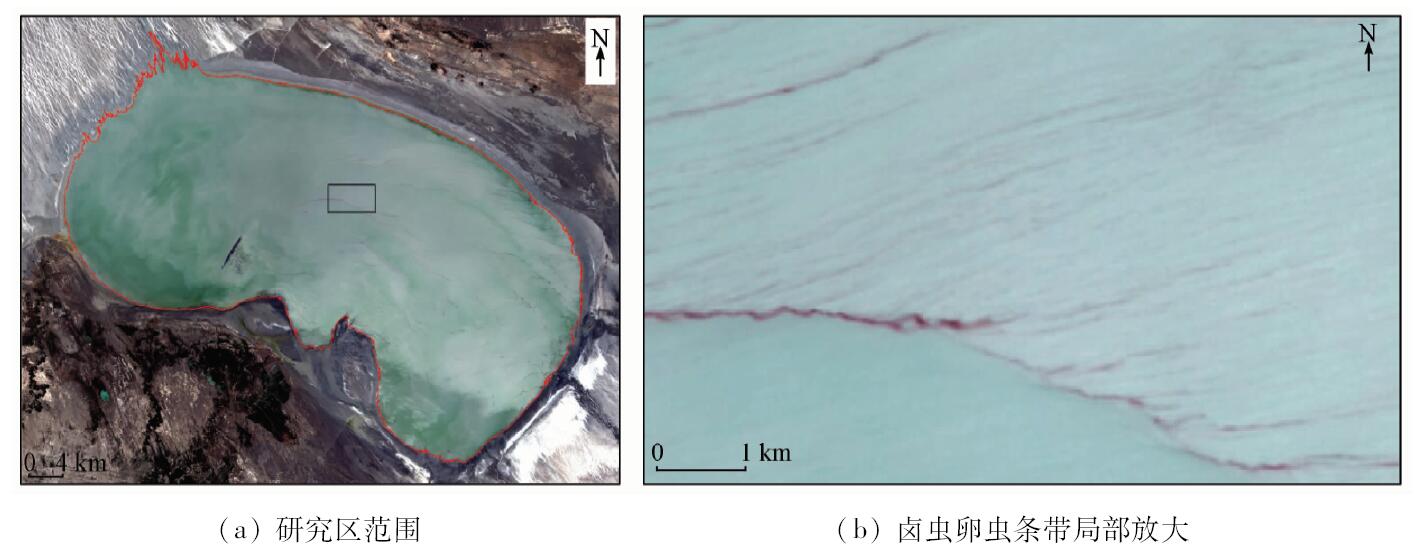
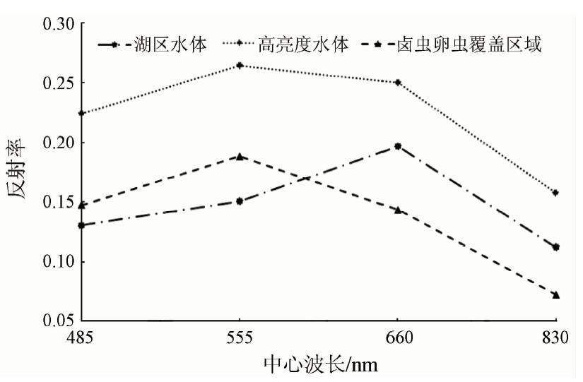
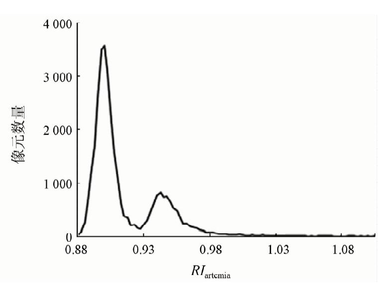
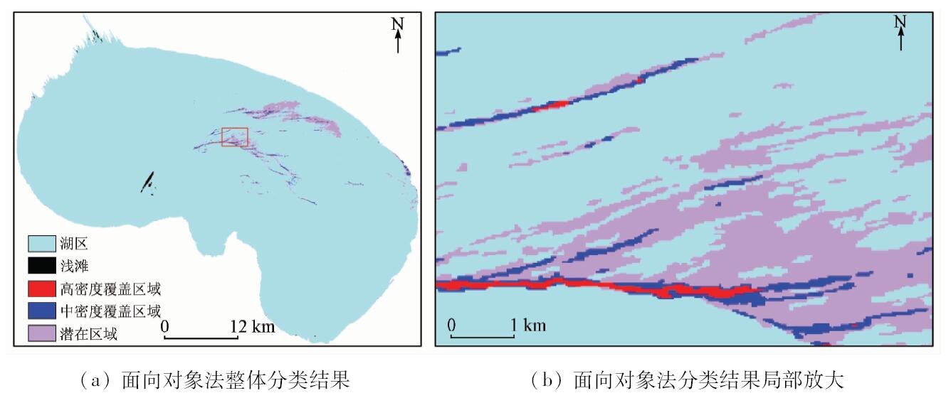
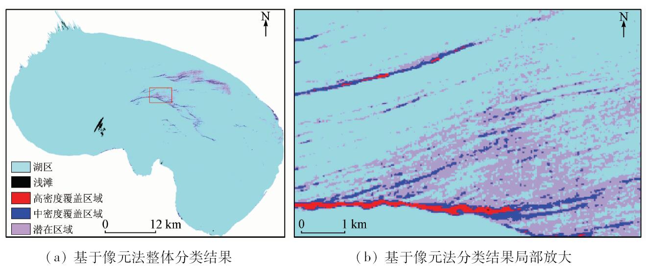
Abstract With the Ebinur Lake as the research area and the ZY-3 multi-spectral image as the data source, the authors preprocessed the data by such means as ortho-rectification, radiometric calibration and atmospheric correction. The authors analyzed the spectral characteristics of different water bodies, found interpretation signs for artemia information extraction, and built the oriented-object artemia information extraction model by the spectral, texture and shape information. The classification results were validated using the confusion matrix, with the overall classification accuracy being 91.74% and Kappa coefficient being 0.89. In addition, classification accuracy between object-oriented method and pixel based method was analyzed and compared for the artemia water of different densities. The classification accuracies of object-oriented method for high density, medium density and potential regions were 95.08%, 92.30% and 91.26%, respectively, whereas those of pixel based method were 90.16%, 87.18% and 86.40%, respectively. The results show that the object-oriented method is more effective than the pixel based method. The object-oriented method greatly avoids the phenomenon of “salt and pepper” and can distinguish the artemia densities. The study can provide the effective method for monitoring the distribution and intensity of artemia and has great significance for scientific and reasonable artemia fishing.
|
| Keywords
object-oriented
artemia and artemia cyst
multi-scale segmentation
interpretation signs
|
|
|
|
Corresponding Authors:
Yong TANG
E-mail: tang@dlou.edu.cn
|
|
Issue Date: 07 December 2018
|
|
|
| [1] |
李磊, 李艳红, 陈成贺日 , 等. 1972—2011年期间艾比湖面积变化研究[J]. 湿地科学, 2014,12(2):263-267.
|
| [1] |
Li L, Li Y H , Chen C H R,et al.Change of Ebinur Area during 1972—2011[J]. Wetland Science, 2014,12(2):263-267.
|
| [2] |
杨超, 王金亮, 李石华 , 等. 抚仙湖流域土地退化动态遥感监测研究[J]. 遥感技术与应用, 2016,31(2):388-396.
doi: 10.11873/j.issn.1004-0323.2016.2.0388
url: http://www.cqvip.com/QK/96858A/201602/668849330.html
|
| [2] |
Yang C, Wang J L, Li S H , et al. Land degradation dynamic remote sensing monitor of Fuxian Lake Basin[J]. Remote Sensing Technology and Application, 2016,31(2):388-396.
|
| [3] |
王莹, 刘其根, 冯权泷 , 等. 基于ETM+影像的千岛湖叶绿素a浓度卫星遥感反演研究[J]. 激光生物学报, 2015,24(5):441-447.
url: http://www.opticsjournal.net/Articles/Abstract?aid=OJ151130000890sYv2y5
|
| [3] |
Wang Y, Liu Q G, Feng Q L , et al. Inversion of chlorophyll-a concentration based on satellite remote sensing in Qiandao Lake[J]. Acta Laser Biology Sinica, 2015,24(5):441-447.
|
| [4] |
张鹏, 陈晓玲, 陆建忠 , 等. 基于遥感的鄱阳湖丰水期悬浮泥沙数值模拟预测[J]. 武汉大学学报(信息科学版), 2017,42(3):369-376.
doi: 10.13203/j.whugis20140880
url: http://d.wanfangdata.com.cn/Periodical/whchkjdxxb201703014
|
| [4] |
Zhang P, Chen X L, Lu J Z , et al. Suspended sediment transport modeling of Poyang Lake in the wet season based on remote sensing data[J]. Geomatics and Information Science of Wuhan University, 2017,42(3):369-376.
|
| [5] |
徐京萍, 张柏, 李方 , 等. 基于MODIS数据的太湖藻华水体识别模式[J]. 湖泊科学, 2008,20(2):191-195.
|
| [5] |
Xu J P, Zhang B, Li F , et al. Detecting modes of cyanobacteria bloom using MODIS data in Lake Taihu[J]. Journal of Lake Sciences, 2008,20(2):191-195.
|
| [6] |
段洪涛, 张寿选, 张渊智 . 太湖蓝藻水华遥感监测方法[J]. 湖泊科学, 2008,20(2):145-152.
doi: 10.3321/j.issn:1003-5427.2008.02.002
url: http://d.wanfangdata.com.cn/Periodical/hpkx200802002
|
| [6] |
Duan H T, Zhang S X, Zhang Y Z . Cyanobacteria bloom monitoring with remote sensing in Lake Taihu[J]. Journal of Lake Sciences, 2008,20(2):145-152.
|
| [7] |
宋瑜, 宋晓东, 郭青海 , 等. 太湖藻华水体的遥感监测与预警[J]. 光谱学与光谱分析, 2011,31(3):753-757.
url: http://www.opticsjournal.net/Articles/Abstract?aid=OJ110428000395SoVrXu
|
| [7] |
Song Y, Song X D, Guo Q H , et al. Remote sensing monitoring and pre-alarming of algal blooms in Taihu Lake[J]. Spectroscopy and Spectral Analysis, 2011,31(3):753-757.
|
| [8] |
贾坤, 李强子, 田亦陈 , 等. 遥感影像分类方法研究进展[J]. 光谱学与光谱分析, 2011,31(10):2618-2623.
url: http://www.opticsjournal.net/Articles/Abstract?aid=OJ111109000170EaHdJg
|
| [8] |
Jia K, Li Q Z, Tian Y C , et al. A review of classification methods of remote sensing imagery[J]. Spectroscopy and Spectral Analysis, 2011,31(10):2618-2623.
|
| [9] |
李德仁, 王密 . “资源三号”卫星在轨几何定标及精度评估[J]. 航天返回与遥感, 2012,33(3):1-6.
|
| [9] |
Li D R, Wang M . On-orbit geometric calibration and accuracy assessment of ZY-3[J]. Spacecraft Recovery and Remote Sensing, 2012,33(3):1-6.
|
| [10] |
李霖, 罗恒, 唐新明 , 等. 资源三号卫星多光谱图像特征分析和质量评价[J]. 国土资源遥感, 2014,26(1):17-24.doi: 10.6046/gtzyyg.2014.01.04.
|
| [10] |
Li L, Luo H, Tang X M , et al. Characteristic analysis and quality assessment of ZY-3 multi-spectral image[J]. Remote Sensing for Land and Resources, 2014,26(1):17-24.doi: 10.6046/gtzyyg.2014.01.04.
|
| [11] |
李晋, 赵庚星, 常春艳 , 等. 基于HSI高光谱和TM图像的土地盐渍化信息提取方法[J]. 光谱学与光谱分析, 2014,34(2):520-525.
url: http://www.opticsjournal.net/Articles/Abstract?aid=OJ1402180002560GcIfL
|
| [11] |
Li J, Zhao G X, Chang C Y , et al. Land salinization information extraction method based on HSI hyperspectral and TM imagery[J]. Spectroscopy and Spectral Analysis, 2014,34(2):520-525.
|
| [12] |
张森, 陈健飞, 龚建周 . 面向对象分类的决策树方法探讨——以Landsat-8OLI为例[J]. 测绘科学, 2016,41(6):117-121,125.
|
| [12] |
Zhang S, Chen J F, Gong J Z . Object-oriented classification based on C5.0 algorithm[J]. Science of Surveying and Mapping, 2016,41(6):117-121,125.
|
| [13] |
Gonzalez R C, Woods R E, Eddins S L . Digital Image Processing[M]. 2nd ed.Beijing:Publishing House of Electronics Industry, 2013: 567-642.
|
| [14] |
Cheng J H, Bo Y C, Zhu Y X , et al. A novel method for assessing the segmentation quality of high-spatial resolution remote-sensing images[J]. International Journal of Remote Sensing, 2014,35(10):3816-3839.
doi: 10.1080/01431161.2014.919678
url: https://www.tandfonline.com/doi/full/10.1080/01431161.2014.919678
|
| [15] |
Benz U C, Hofmann P, Willhauck G , et al. Multi-resolution,object-oriented fuzzy analysis of remote sensing data for GIS-ready information[J]. ISPRS Journal of photogrammetry and Remote Sensing, 2004,58(3/4):239-258.
doi: 10.1016/j.isprsjprs.2003.10.002
url: http://linkinghub.elsevier.com/retrieve/pii/S0924271603000601
|
| [16] |
龚健雅, 姚璜, 沈欣 . 利用AdaBoost算法进行高分辨率影像的面向对象分类[J]. 武汉大学学报(信息科学版), 2010,35(12):1440-1443,1448.
|
| [16] |
Gong J Y, Yao H, Shen X . Object-oriented classification of high spatial-resolution remote sensing imagery based on AdaBoost[J]. Geomatics and Information Science of Wuhan University, 2010,35(12):1440-1443,1448.
|
|
Viewed |
|
|
|
Full text
|
|
|
|
|
Abstract
|
|
|
|
|
Cited |
|
|
|
|
| |
Shared |
|
|
|
|
| |
Discussed |
|
|
|
|
 2018,
Vol. 30
2018,
Vol. 30