|
|
|
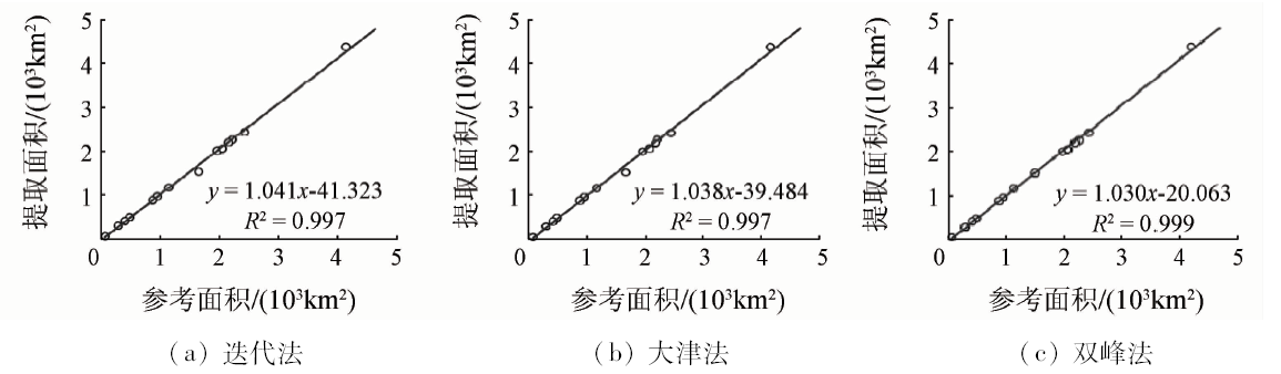
Abstract Based on 15 lakes located in different regions of China, the authors calculated the normalized difference water index (NDWI) for GF-1 satellite remote sensing images, and then employed iterative method, Otsu method and histogram bimodal method for segmentation threshold selection and water information extraction, and finally analyzed the threshold selection results and water information extraction results of the three methods. According to the results obtained, iterative method is similar to the threshold chosen by Otsu method, and the difference between the thresholds selected by histogram bimodal method is large; the iterative method is more efficient; the extraction accuracy of bimodal method is the highest, and its fitting effect is the best. This study can provide selection strategies of adaptive threshold segmentation method for extracting accurate water information from GF-1 images.
|
| Keywords
GF-1 data
NDWI
adaptive threshold
water extraction
|
|
|
|
Corresponding Authors:
Lingkui MENG
E-mail: Lkmeng@whu.edu.cn
|
|
Issue Date: 15 March 2019
|
|
|
| [1] |
吉红霞, 范兴旺, 吴桂平 , 等. 离散型湖泊水体提取方法精度对比分析[J]. 湖泊科学, 2015,27(2):327-334.
doi: 10.18307/2015.0218
url: http://d.wanfangdata.com.cn/Periodical/hpkx201502018
|
| [1] |
Ji H X, Fan X W, Wu G P , et al. Accuracy comparison and analysis of methods for water area extraction of discrete lakes[J]. Journal of Lake Sciences, 2015,27(2):327-334.
|
| [2] |
胡卫国, 孟令奎, 张东映 , 等. 资源一号02C星图像水体信息提取方法[J]. 国土资源遥感, 2014,26(2):43-47.doi: 10.6046/gtzyyg.2014.02.08.
doi: 10.6046/gtzyyg.2014.02.08
url: http://d.wanfangdata.com.cn/Periodical/gtzyyg201402008
|
| [2] |
Hu W G, Meng L K, Zhang D Y , et al. Methods of water extraction from ZY-1 02C satellite imagery[J]. Remote Sensing for Land and Resources, 2014,26(2):43-47.doi: 10.6046/gtzyyg.2014.02.08.
|
| [3] |
段秋亚, 孟令奎, 樊志伟 , 等. GF-1卫星影像水体信息提取方法的适用性研究[J]. 国土资源遥感, 2015,27(4):79-84.doi: 10.6046/gtzyyg.2015.04.13.
doi: 10.6046/gtzyyg.2015.04.13
url: http://www.cqvip.com/QK/91397X/201504/666795395.html
|
| [3] |
Duan Q Y, Meng L K, Fan Z W , et al. Applicability of the water information extraction method based on GF-1 image[J]. Remote Sensing for Land and Resources, 2015,27(4):79-84.doi: 10.6046/gtzyyg.2015.04.13.
|
| [4] |
陈文倩, 丁建丽, 李艳华 , 等. 基于国产GF-1遥感影像的水体提取方法[J]. 资源科学, 2015,37(6):1166-1172.
url: http://www.cnki.com.cn/Article/CJFDTotal-ZRZY201506009.htm
|
| [4] |
Chen W Q, Ding J L, Li Y H , et al. Extraction of water information based on China-made GF-1 remote sense image[J]. Resources Science, 2015,37(6):1166-1172.
|
| [5] |
简兴, 陈鸿, 邢忠亚 , 等. 利用遥感技术提取水体面积时水体类型对阈值的影响[J]. 科学技术与工程, 2014,14(18):267-270,274.
doi: 10.3969/j.issn.1671-1815.2014.18.052
url: http://www.cnki.com.cn/Article/CJFDTotal-KXJS201418054.htm
|
| [5] |
Jian X, Chen H, Xing Z Y , et al. Influence of waterbody types on threshold of waterbody area extraction using remote sensing technology[J]. Science Technology and Engineering, 2014,14(18):267-270,274.
|
| [6] |
袁欣智, 江洪, 陈芸芝 , 等. 一种应用大津法的自适应阈值水体提取方法[J]. 遥感信息, 2016,31(5):36-42.
doi: 10.3969/j.issn.1000-3177.2016.05.006
url: http://d.wanfangdata.com.cn/Periodical/ygxx201605006
|
| [6] |
Yuan X Z, Jiang H, Chen Y Z , et al. Extraction of water body information using adaptive threshold value and Otsu algorithm[J]. Remoting Sensing Information, 2016,31(5):36-42.
|
| [7] |
徐蓉, 张增祥, 赵春哲 . 湖泊水体遥感提取方法比较研究[J]. 遥感信息, 2015,30(1):111-118.
doi: 10.3969/j.issn.1000-3177.2015.01.019
url: http://www.cnki.com.cn/Article/CJFDTotal-YGXX201501019.htm
|
| [7] |
Xu R, Zhang Z X, Zhao C Z . Different models used in extraction of lake water body based on MODIS data[J]. Remoting Sensing Information, 2015,30(1):111-118.
|
| [8] |
马荣华, 杨桂山, 段洪涛 , 等. 中国湖泊的数量、面积与空间分布[J]. 中国科学(地球科学), 2011,41(3):394-401.
url: http://2010.cqvip.com/QK/98491A/201103/37550266.html
|
| [8] |
Ma R H, Yang G S, Duan H T , et al. China’s lakes at present:Number,area and spatial distribution[J]. Science China Earth Science, 2011,41(3):394-401.
|
| [9] |
McFeeters S K . The use of the normalized difference water index (NDWI) in the delineation of open water features[J]. International Journal of Remote Sensing, 1996,17(7):1425-1432.
doi: 10.1080/01431169608948714
url: https://www.tandfonline.com/doi/full/10.1080/01431169608948714
|
| [10] |
徐涵秋 . 利用改进的归一化差异水体指数(MNDWI)提取水体信息的研究[J]. 遥感学报, 2005,9(5):589-595.
doi: 10.3321/j.issn:1007-4619.2005.05.012
url: http://d.wanfangdata.com.cn/Periodical/ygxb200505012
|
| [10] |
Xu H Q . A study on information extraction of water body with the modified normalized difference water index (MNDWI)[J]. Journal of Remote Sensing, 2005,9(5):589-595.
|
| [11] |
李琳琳 . 遥感图像分割中阈值的自动选取技术研究[D]. 兰州:兰州大学, 2012.
|
| [11] |
Li L L . A Study on Auto-thresholding Selection Methods for Image Segmentation[D]. Lanzhou:Lanzhou University, 2012.
|
| [12] |
Otsu N . A threshold selection method from gray-level histograms[J]. IEEE Transactions on Systems,Man and Cybernetics, 1979,9(1):62-66.
doi: 10.1109/TSMC.1979.4310076
url: http://ieeexplore.ieee.org/document/4310076/
|
| [13] |
杨修国 . 图像阈值分割方法研究与分析[D]. 上海:华东师范大学, 2009.
|
| [13] |
Yang X G . Research and Improvement on the Histogram Bimodal Method[D]. Shanghai:East China Normal University, 2009.
|
| [14] |
韦玉春, 汤国安, 汪闽 . 遥感数字图像处理教程[M]. 北京: 科学出版社, 2015.
|
| [14] |
Wei Y C, Tang G A, Wang M. Remote Sensing Digital Image Processing Tutorial[M]. Beijing: Science Press, 2015.
|
|
Viewed |
|
|
|
Full text
|
|
|
|
|
Abstract
|
|
|
|
|
Cited |
|
|
|
|
| |
Shared |
|
|
|
|
| |
Discussed |
|
|
|
|
 2019,
Vol. 31
2019,
Vol. 31
 )
)